This website works best with a newer web browser such as Chrome, Firefox, Safari or Microsoft
Edge. Internet Explorer is not supported by this website.
1-minute Mesoscale Domain Sector GOES-19 (GOES-East) Nighttime Microphysics RGB + daytime True Color RGB images from the CSPP GeoSphere site (above) showed the formation of a long power plant plume (nighttime shades of red) embedded within a supercooled water droplet cloud layer (nighttime shades of yellow) that grew in length and width as... Read More
1-minute GOES-19 Nighttime Microphysics RGB + daytime True Color RGB images, from 0901-1900 UTC on 21 February [click to play MP4 animation]
1-minute Mesoscale Domain Sector GOES-19 (GOES-East)Nighttime Microphysics RGB + daytime True Color RGB images from the CSPP GeoSphere site (above) showed the formation of a long power plant plume (nighttime shades of red) embedded within a supercooled water droplet cloud layer (nighttime shades of yellow) that grew in length and width as it moved southeastward across southern Wisconsin on 21 February 2026. The power plant plume had the effect of eroding the supercooled water droplet cloud layer — via glaciation, initiated by the power plant emission of particles that acted as efficient ice nuclei — which then caused snow to fall from the cloud (leaving holes and thin cloud segments that were very apparent in True Color RGB images).
A toggle between the GOES-19 Night Fog Brightness Temperature Difference (BTD) image and Cloud Top Phase derived product at 1200 UTC (below) confirmed that the cloud layer across southern Wisconsin was composed of supercooled water droplets (lime green enhancement).
GOES-19 Night Fog BTD image and Cloud Top Phase derived product at 1200 UTC on 21 February [click to enlarge]
1-minute GOES-19 Night Fog BTD + daytime Visible images (below) suggested that the Columbia Energy Center in northwest Columbia County was the source of the power plant plume.
1-minute GOES-19 Night Fog BTD + daytime Visible images, from 0801-1819 UTC on 21 February [click to play MP4 animation]
The evening of 19 February featured a rare-for-the-midwest winter tornado outbreak. Tornadoes were reported in several locations in southern Illinois and Indiana, accompanied by numerous reports of hail and damaging winds. Much of the severe weather happened after dark as well. Multiple tornadoes were reported across the two states, with... Read More
The evening of 19 February featured a rare-for-the-midwest winter tornado outbreak. Tornadoes were reported in several locations in southern Illinois and Indiana, accompanied by numerous reports of hail and damaging winds. Much of the severe weather happened after dark as well. Multiple tornadoes were reported across the two states, with the most significant being an EF2 tornado with a nearly four mile long track in the western part of Bloomington, Indiana.
Earlier in the day, rain from morning thunderstorms moistened the region (see this blog post about those storms). Dew points rose from the low 50s to 60 degrees or more. After the morning storms dissipated, daytime heating caused temperatures to reach 70 in certain locations, providing ample energy for vertical motion. As noted in the earlier blog post from this day, this region is at the heart of one of the nation’s largest radiosonde gaps making it hard to know how the atmosphere may be destabilizing. However, NUCAPS profile retrievals can really help to fill in where conventional observations are lacking. Here is a NUCAPS satellite-based vertical profile from near Bloomington, Indiana, in the south-central part of the state. This profile was obtained from the always excellent NUCAPS Savvy site operated by NASA SPoRT. This is from the NOAA-20 polar orbiting satellite overpass around 1900 UTC, or 2:00 PM ET.
At first glance, the profile doesn’t seem to provide a whole lot to be concerned about. The mixed-layer cape is only 54 J/kg, far below values that we’d expect to be supportive of deep moist convection. The most unstable cape isn’t much better at 227 J/kg. Still, there are some interesting things here. First, the DCAPE is rather robust at 603 J/kg. Remember, one of the limitations of NUCAPS profiles is that the retrieved vertical structure is much smoother than truth: inversions and moist layers are sanded down compared to what you would see on a radiosonde. Therefore, this DCAPE value is likely high enough to support strong downdrafts and significant outflow winds. The next thing to note is the array of low-level lapse rates in the bottom right of the figure above. Those are all steeper than you might normally expect for a winter’s day in Indiana, and indicate that instability might be present despite what the CAPE values say. Finally, the NUCAPS-retrieved surface conditions can often be an underestimate of the true environment, especially for the dew point. At 2:00 PM, the Bloomington Airport (KBMG) reported a surface temperature of 66 F (19 C) and a surface dew point of 57 F (14 C). The surface temperature as seen by NUCAPS is quite good, however it really underestimated the dew point. If you assume a 14 C surface dew point in the above sounding, you would get a remarkably larger CAPE value. (The impact that making the simple change to observed surface values can have on satellite-derived measures of instability is explored in this paper by CIMSS and SSEC researchers).
It’s worth looking at those lapse rates some more. The Gridded NUCAPS product allows us to see the spatial distribution of NUCAPS-derived values. Here, for example is the 850-500 mb Gridded NUCAPS lapse rate from the NOAA-20 overpass as captured by the NASA SPoRT Viewer. Note all the light greens and yellows in central and southern Indiana. It looks like those 7+ C/km lapse rates are quite common throughout the region, implying that there’s actually some widespread instability.
The same polar orbiting satellite that gave us the NUCAPS data also provides observations of total precipitable water (TPW) from the ATMS instrument. This image was obtained from the direct broadcast antenna here at CIMSS and SSEC, and shows the relatively moist environment over the southern parts of Illinois and Indiana, with TPW values exceeding 30 mm.
The following loop shows the evolution of the environment from 1100 UTC (6:00 AM ET, 5:00 AM CT) through the tornadic period on to 200 UTC (9:00 PM ET, 8:00 PM CT). Initiation occurred along an advancing frontal boundary. One of the interesting things to see about this event is that the convective clouds are relatively shallow. Normally, you’d expect to see much colder cloud top temperatures for tornadic storms but these seemed to reach only about -50 C or so. This isn’t a case of an extremely low tropopause, as the 00 UTC sounding from Wilmington, OH (near Cincinnati) showed a tropopause temperature of -60 at a pressure of around 210 hPa. Instead, these are clouds that just didn’t grow to their maximum possible height. However, with those low level lapse rates being what they were, perhaps they didn’t need to.
As an even that spanned the transition from day to night, many of the most popular satellite RGB products for detecting convective development were losing their utility. This is because those products depend on near-infrared reflectance or emission, and once the sun sets those values go close to zero. Still, there are a pair of RGB products worth investigating. The first is the Air Mass RGB. Normally, it’s used for more dynamical applications, like identifying regions of potential vorticity or stratospheric intrusions. However, at a glance it can also inform about the distribution of different air mass types in a region. The warmer and moister air masses are green, while the colder and dryer air masses are blue. Where the colors shift rapidly over a small difference can be indicative of a front. Based on this, there appears to be a north-south boundary along the southern Mississippi River and into eastern Illinois at the start of the following animation. As this pushes eastward, convection fires along that boundary in the region of the country that we already identified as having widespread instability from the Gridded NUCAPS lapse rates. An advantage of this product is its 24/7 utility since it only depends on longwave IR bands that are not impacted by the presence or lack of solar radiation.
The Night Microphysics RGB is a go-to standard for any meteorologist working the night shift. The deeper convection is found in the regions with red or speckled yellow coloring. While perhaps not as useful as some of the daytime products in identifying the regions that are about to experience rapid vertical development, it is still well-suited for keeping abreast of where the most significant weather is taking place. Note that sunset in southern Indiana was around 6:30 PM local time (2330 UTC) and the Night Microphysics RGB depends on the 3.9 micron channel whose interpretation changes immensely between day and night. Therefore, you can only use this product at night which means only the latter part of this animation is truly useful. Still, at the end, we see numerous modestly deep cells across the middle of Indiana as well as stretching from southeastern Iowa into southeastern Illinois.
To provide some additional context to this event, here is the radar-observed reflectivity and storm relative velocity over Bloomington from the NEXRAD radar in Indianapolis. The strong gate-to-gate shear indicates a strong mesocyclone that can be associated with tornadic activity. The Indianapolis NWS office issued a rare Particularly Dangerous Situation (PDS) warning for this event, in part based on the strong rotation seen in the radar.
The CIMSS ProbSevere product was also useful for this event. The red polygons note the location of tornado warnings issued by the NWS Weather Forecast Office in Indianapolis, while the contours note the locations of ProbSevere-identified areas of potential severe weather formation. The contour within the tornado warning polygons showed that ProbSevere predicted a 75% chance of severe weather within that contour, including a 59% chance of a tornado. The Monroe County Airport just outside of Bloomington recorded a 70 mph wind gust before losing all observations due to lost power.
While it may be winter, unseasonably warm conditions on February 19 were able to support convection across portions of the midwest and into southern Ontario. Convection began firing at multiple locations, including metropolitan St. Louis, Missouri; northeastern Indiana, and southeastern Illinois. To start with, let’s look at the 1500 UTC... Read More
While it may be winter, unseasonably warm conditions on February 19 were able to support convection across portions of the midwest and into southern Ontario. Convection began firing at multiple locations, including metropolitan St. Louis, Missouri; northeastern Indiana, and southeastern Illinois. To start with, let’s look at the 1500 UTC (9 AM CT, 10 AM ET) surface map as analyzed by NOAA’s Weather Prediction Center. Here, a weak frontal boundary stretches from Ohio southwesterly to a center of circulation in northeastern Kansas. Along and south of this boundary, conditions are quite moist for this time of year with dew points in the mid to upper 50s. There’s also evidence of a weak shortwave at 500 hPa over southern Illinois and western Kentucky that could be abetting any convection that develops (see here).
This can be a challenging part of the country for upper air observations as one of the nation’s larger radiosonde gaps is found between Lincoln, Illinois; Nashville, Tennessee; and Wilmington (suburban Cincinnati), Ohio. Still, looking at some of these soundings can tell us some things. The morning sounding from Nashville, for example, shows small amount of CAPE, which, when assisted by some weak upper-level dynamics, can cause some deeper convection to take place.
The GOES-19 mesoscale sector was active over the region, enabling a fine-scaled view of the evolution of these systems. We’ll start with the Day Cloud Phase Distinction RGB. This product is well-suited to identifying fast-developing cumulus which can quickly evolve into deep convection. The congested clouds transitioning from green to yellow are the cells to watch, as green represents glaciating clouds and yellow notes thick clouds with ice particles which are consistent with deep moist convection.
Similarly, the day convection product can help identify locations where convection is developing. Yellow spots indicate where strong updrafts are taking place, as this is where both cold cloud tops and small ice particle size (associated with young convection) are found. Here, we see that actively developing storms are taking place in northeastern Indiana, south-central Michigan, the Ontario peninsula, and the southern part of the Indiana/Illinois border.
Let’s take a closer look at the development of the cell on the Illinois/Indiana border. The following animation depicts both the day cloud phase distinction (top) and day convection (bottom) RGB products. The CIMSS LightningCast product has been overlaid on both RGB products. There is an existing area of convection on the western edge of the image, while the new cell can be seen developing in the middle of the animation. The first contours of lightning probability from LightningCast are seen at the same as the signs of convection (yellow and green in the top, yellow on the bottom) in the RGBs.
When AWIPS renders animations, the colorization can appear somewhat muted. Here’s a single frame from the above animation that better depects the colors as they are seen in AWIPS or SSEC RealEarth.
Additional convection is expected later in the day in this region as the first round moistened the environment and continued heating is expected to further destabilize the atmosphere.
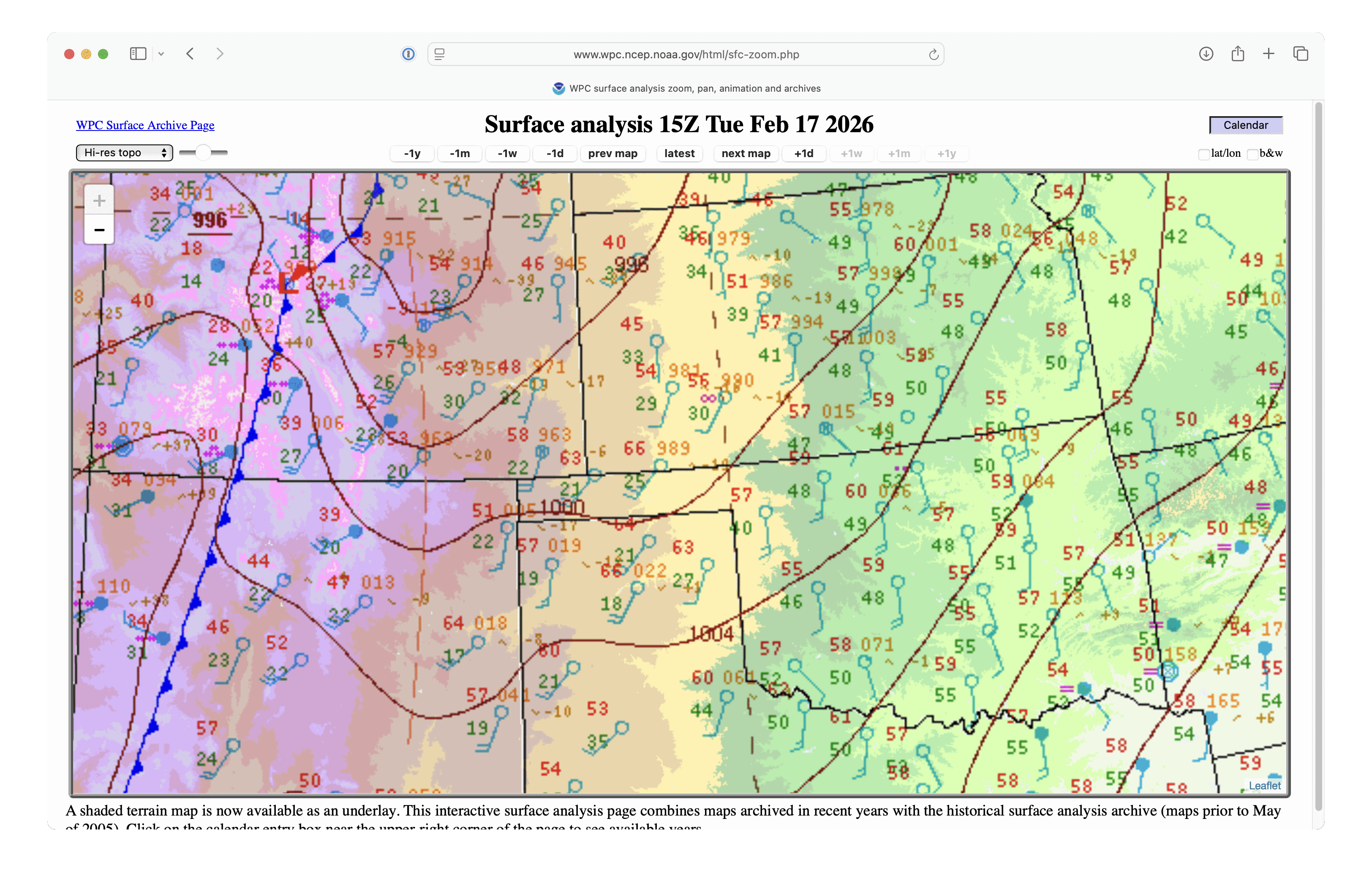
The Storm Prediction Center issued Extreme Fire Weather Outlooks (1200 UTC | 1700 UTC) that covered much of the central and southern Plains on 17 February 2026. A large-scale view of 1-minute Mesoscale Domain Sector GOES-19 (GOES-East) Visible images (above) included plots of Fire Mask pixels — which depicted the development of numerous wildfires, most notably along... Read More
1-minute GOES-19 Visible images with overlays of Fire Mask pixels, SPC Fire Weather Outlooks (yellow contours), and Surface Fronts (cyan) from 1701 UTC on 17 February to 0000 UTC on 18 February [click to play MP4 animation]
The Storm Prediction Center issued Extreme Fire Weather Outlooks (1200 UTC | 1700 UTC) that covered much of the central and southern Plains on 17 February 2026. A large-scale view of 1-minute Mesoscale Domain Sector GOES-19 (GOES-East) Visible images (above) included plots of Fire Mask pixels — which depicted the development of numerous wildfires, most notably along the Oklahoma/Kansas border.
A closer view using 1-minute GOES-19 Shortwave Infrared images (below) showed the Ranger Road Fire that began to burn in Beaver County, Oklahoma around 1716 UTC — and strong SW winds (with peak gusts in the 50-56 kt range) ahead of an approaching cold front (surface analyses) helped this fire make a rapid 65-mile run to the northeast, crossing the border into Meade/Clark/Comanche Counties in far southern Kansas. The Ranger Road Fire burned at least 145000 acres, and prompted the issuance of Fire Warnings and evacuation orders along/ahead of its path.
1-minute GOES-19 Shortwave Infrared images, with plots of Surface Wind barbs and Peak Wind Gusts (yellow/red) and Surface Fronts, from 1701 UTC on 17 February to 0100 UTC on 18 February [click to play MP4 animation]
Near the leading edge of the Ranger Road Fire (in Clark County in far southern Kansas), it first exhibited a maximum 3.9 µm brightness temperature of 137.77ºC — which is the saturation temperature of GOES-19 Band 7 detectors — at 2354 UTC (below).
GOES-19 Shortwave Infrared image at 2354 UTC on 17 February, with a cursor sample showing a 3.9 µm infrared brightness temperature of 137.77ºC [click to enlarge]
1-minute GOES-19 GeoColor RGB images with an overlay of Next Generation Fire System (NGFS) Fire Detection polygons (below) displayed the thermal signatures, smoke plume and pyrocumulus clouds associated with the Ranger Road Fire. Surface observations in the vicinity of the fire depicted wind gusts as high as 65 mph at 2140 UTC.
1-minute GOES-19 GeoColor RGB images with an overlay of NGFS Fire Detection polygons (with/without plots of surface observations), from 1700 UTC on 17 February to 0000 UTC on 18 February [click to play MP4 animation]
The Ranger Road wildfire continues to burn across a large portion of NE Beaver county in the Oklahoma Panhandle. A Fire Warning remains in effect through 8:30 PM, including the towns of Knowles and Gate. #phwx#okwxpic.twitter.com/Rm9Qn0xgjH


