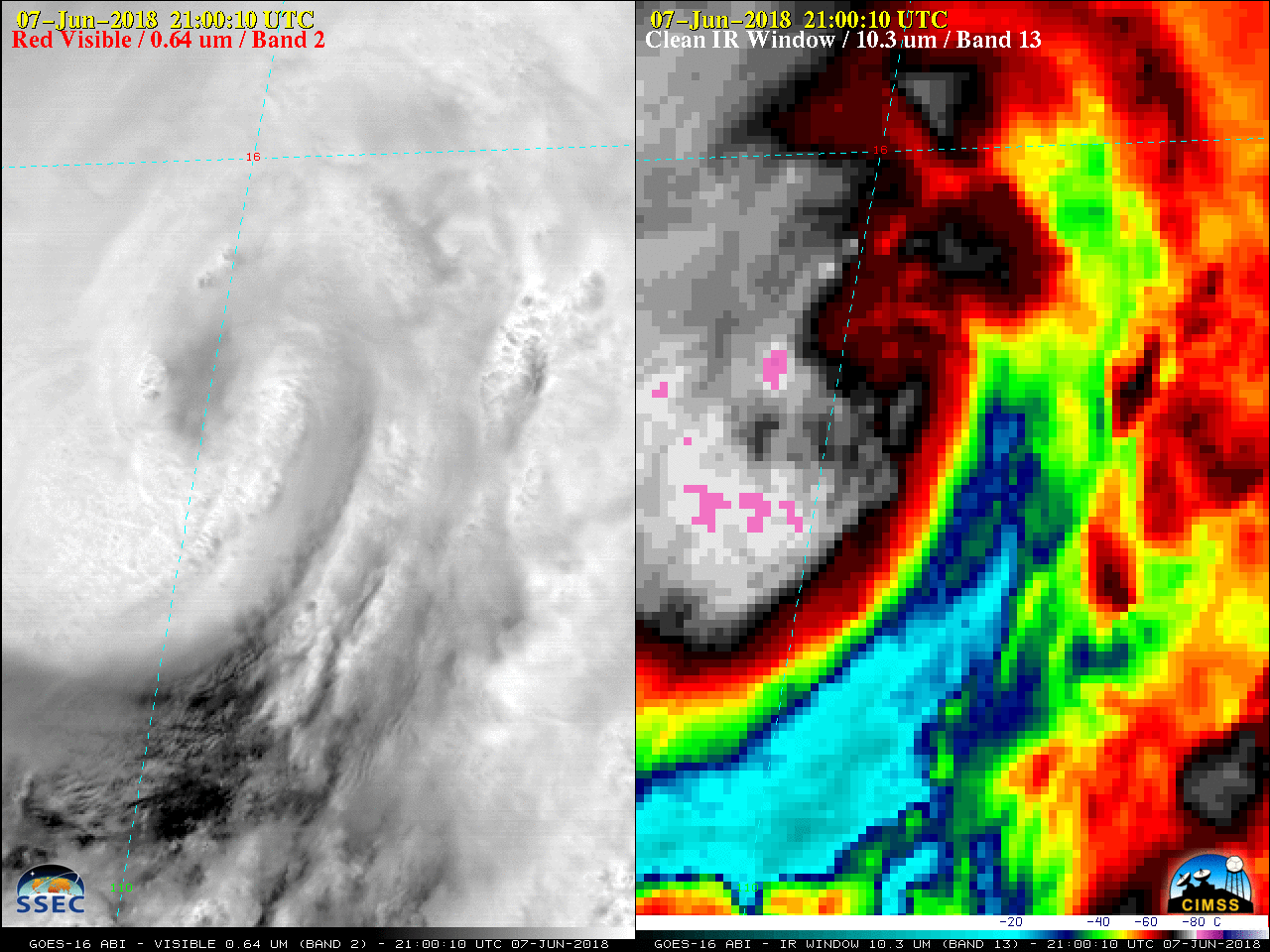
GOES-16 “Red” Visible (0.64 µm, left) and “Clean” Infrared Window (10.3 µm, right) images [click to play MP4 animation]
Tropical Storm Aletta was upgraded to Hurricane Aletta at
21 UTC on 07 June 2018. As was the case on
06 June, a GOES-16 Mesoscale Domain Sector centered over the tropical cyclone provided 1-minute data — and an eye eventually became apparent on “Red” Visible (
0.64 µm) and “Clean” Infrared Window (
10.3 µm) imagery
(above).
DMSP-15, DMSP-17 and GPM GMI Microwave (85 GHz) imagery from the CIMSS Tropical Cyclones site (below) showed an increase in organization of the eye structure as the day progressed.
![DMSP-15 SSMI Microwave image [click to enlarge]](http://cimss.ssec.wisc.edu/satellite-blog/wp-content/uploads/2018/06/180607_1022utc_dmsp15_ssmi_microwave_Aletta.jpeg)
DMSP-15 SSMI Microwave image [click to enlarge]
![DMSP-17 SSMIS Microwave image [click to enlarge]](http://cimss.ssec.wisc.edu/satellite-blog/wp-content/uploads/2018/06/180607_1356utc_dmsp17_ssmis_microwave_Aletta.jpeg)
DMSP-17 SSMIS Microwave image [click to enlarge]
![GPM GMI Microwave image [click to enlarge]](http://cimss.ssec.wisc.edu/satellite-blog/wp-content/uploads/2018/06/180608_0031utc_gmi_microwave_Aletta.jpeg)
GPM GMI Microwave image [click to enlarge]
===== 08 June Update =====

GOES-16 “Clean” Infrared Window (10.3 µm) images [click to play MP4 animation]
Aletta went through a period of rapid intensification (
ADT |
SATCON), reaching Category 4 status by
15 UTC on 08 June. 1-minute GOES-16 Infrared (10.3 µm) images
(above) showed the eye becoming more well-defined during the pre-dawn hours.
After sunrise, GOES-16 Visible images (below) initially hinted at the presence of mesovortices within the eye of Aletta.

GOES-16 “Red” Visible (0.64 µm, left) and “Clean” Infrared Window (10.3 µm, right) images [click to play MP4 animation]
Aletta had been moving over relatively warm water and within an environment characterized by low values of
deep-layer wind shear (below) — both of which were favorable factors for intensification. An animation of the deep-layer wind shear over the East Pacific Ocean during 06-07 June is available
here.
![Sea Surface Temperature and Deep-Layer Wind Shear products [click to enlarge]](http://cimss.ssec.wisc.edu/satellite-blog/wp-content/uploads/2018/06/180608_sst_shear_Aletta.jpeg)
Sea Surface Temperature and Deep-Layer Wind Shear products [click to enlarge]
Aletta peaked in intensity later in the day on 08 June (
ADT |
SATCON) — as pointed out by
NHC “This is also consistent with GOES-16 measurements of increased inner-core lightning observed to be occurring to the east of the eastern eyewall, which some research suggests corresponds to a halting of the intensification process”. GOES-16 Infrared (10.3 µm) imagery with
GLM Group Density counts are shown below.

GOES-16 “Clean” Infrared Window (10.3 µm) with GLM Group Density counts [click to play MP4 animation]