Eruption of the Raikoke volcano in the Kuril Islands
![Himawari-8 False Color RGB images [click to play animation | MP4]](https://cimss.ssec.wisc.edu/satellite-blog/wp-content/uploads/sites/5/2019/06/190621_himawari8_so2_rgb_Raikoke_anim.gif)
Himawari-8 False Color RGB images [click to play animation | MP4]
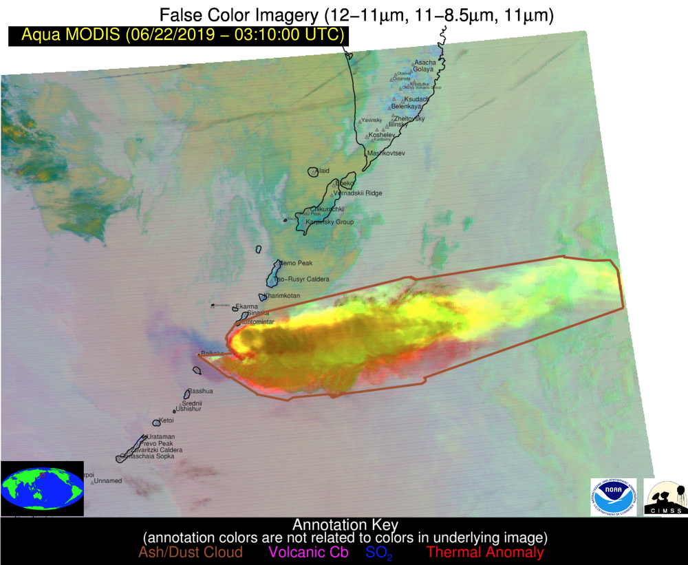
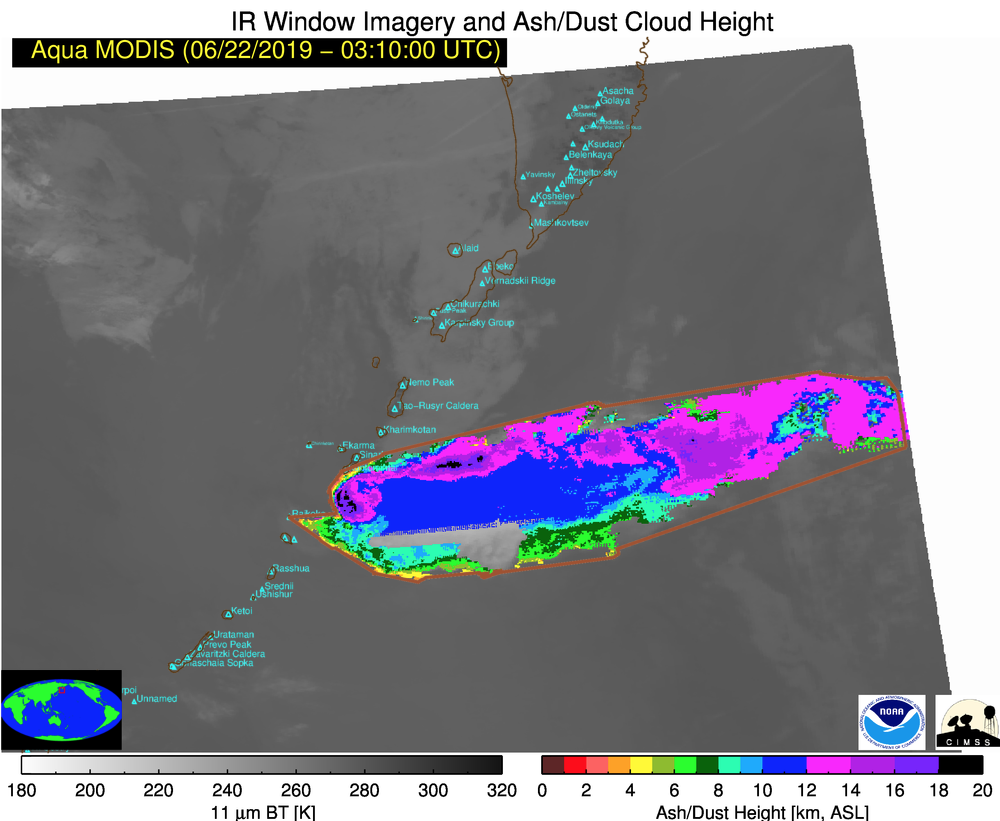
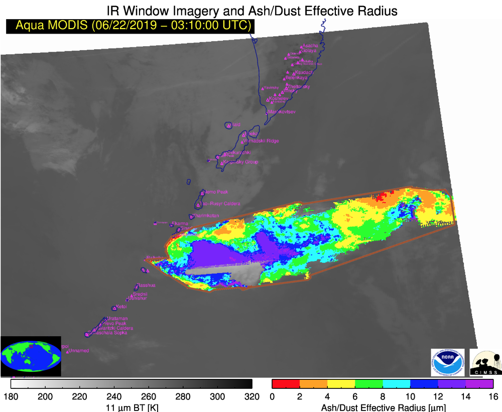
A comparison of an Aqua MODIS False Color RGB image with the corresponding Ash Height, Ash Loading and Ash Effective Radius retrieved products at 0310 UTC on 22 June (below) indicated maximum ash height values of 18-20 km (black pixels) immediately downwind of the eruption site. Maximum Himawari-8 Ash Height values were in the 16-18 km range.
![Aqua MODIS False Color RGB, Ash Height, Ash Loading and Ash Effective Radius at 0310 UTC on 22 June [click to enlarge]](https://cimss.ssec.wisc.edu/satellite-blog/wp-content/uploads/sites/5/2019/06/190622_0310utc_aqua_modis_falseColor_ashHeight_ashLoading_ashRadius_Raikoke_anim.gif)
Aqua MODIS False Color RGB image with Ash Height, Ash Loading and Ash Effective Radius retrieved products [click to enlarge]
![Water Vapor images from Himawari-8: Upper-level (6.2 µm, top), Mid-level (6.9 µm, middle) and Low-level (7.3 µm, bottom) [click to play animation | MP4]](https://cimss.ssec.wisc.edu/satellite-blog/wp-content/uploads/sites/5/2019/06/190621_himawari8_waterVapor_Raikoke_anim.gif)
Water Vapor images from Himawari-8: Upper-level (6.2 µm, top), Mid-level (6.9 µm, middle) and Low-level (7.3 µm, bottom) [click to play animation | MP4]
![Water Vapor images from GOES-17: Upper-level (6.2 µm, top), Mid-level (6.9 µm, middle) and Low-level (7.3 µm, bottom) [click to play animation | MP4]](https://cimss.ssec.wisc.edu/satellite-blog/wp-content/uploads/sites/5/2019/06/190621_goes17_waterVapor_Raikoke_anim.gif)
Water Vapor images from GOES-17: Upper-level (6.2 µm, top), Mid-level (6.9 µm, middle) and Low-level (7.3 µm, bottom) [click to play animation | MP4]
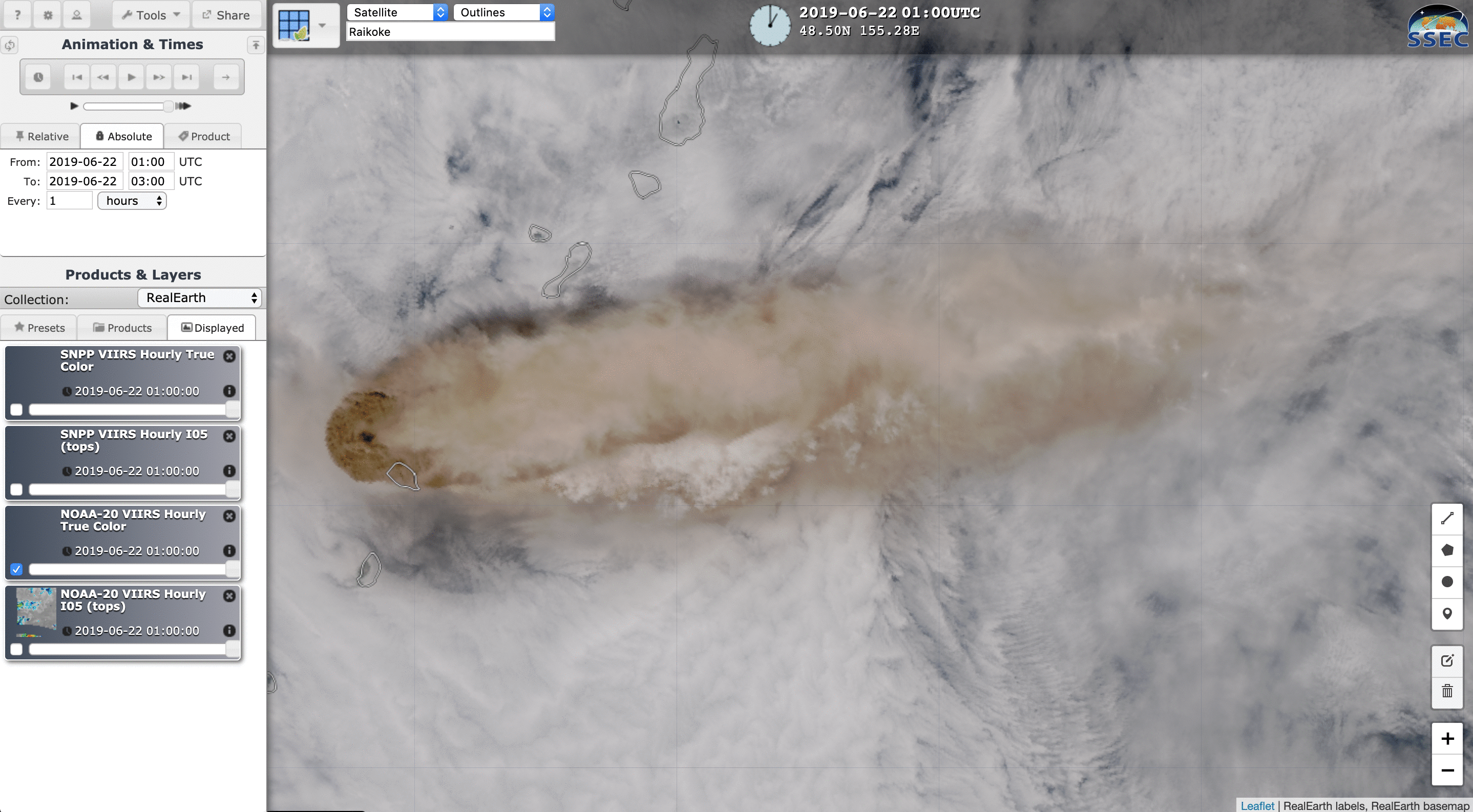
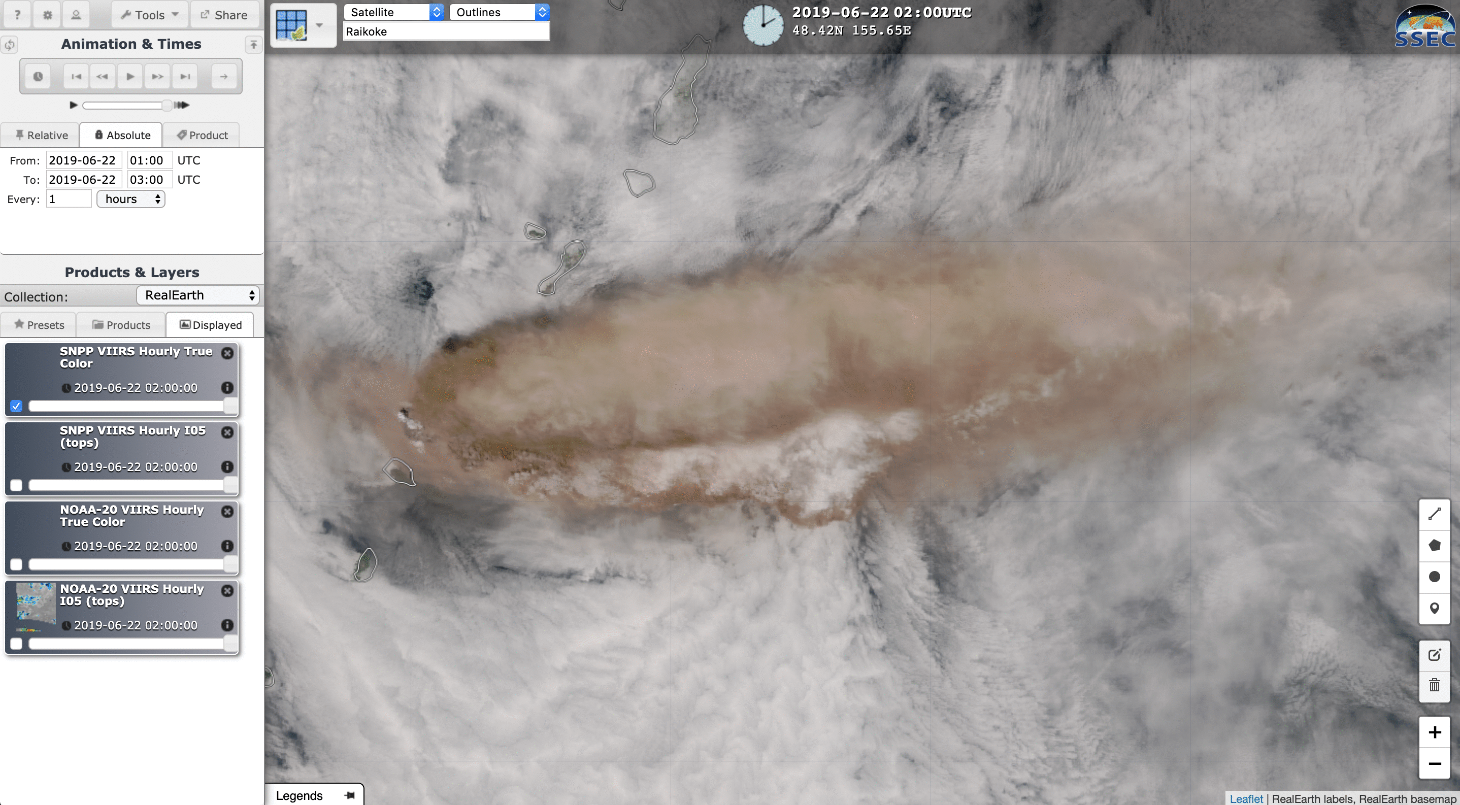
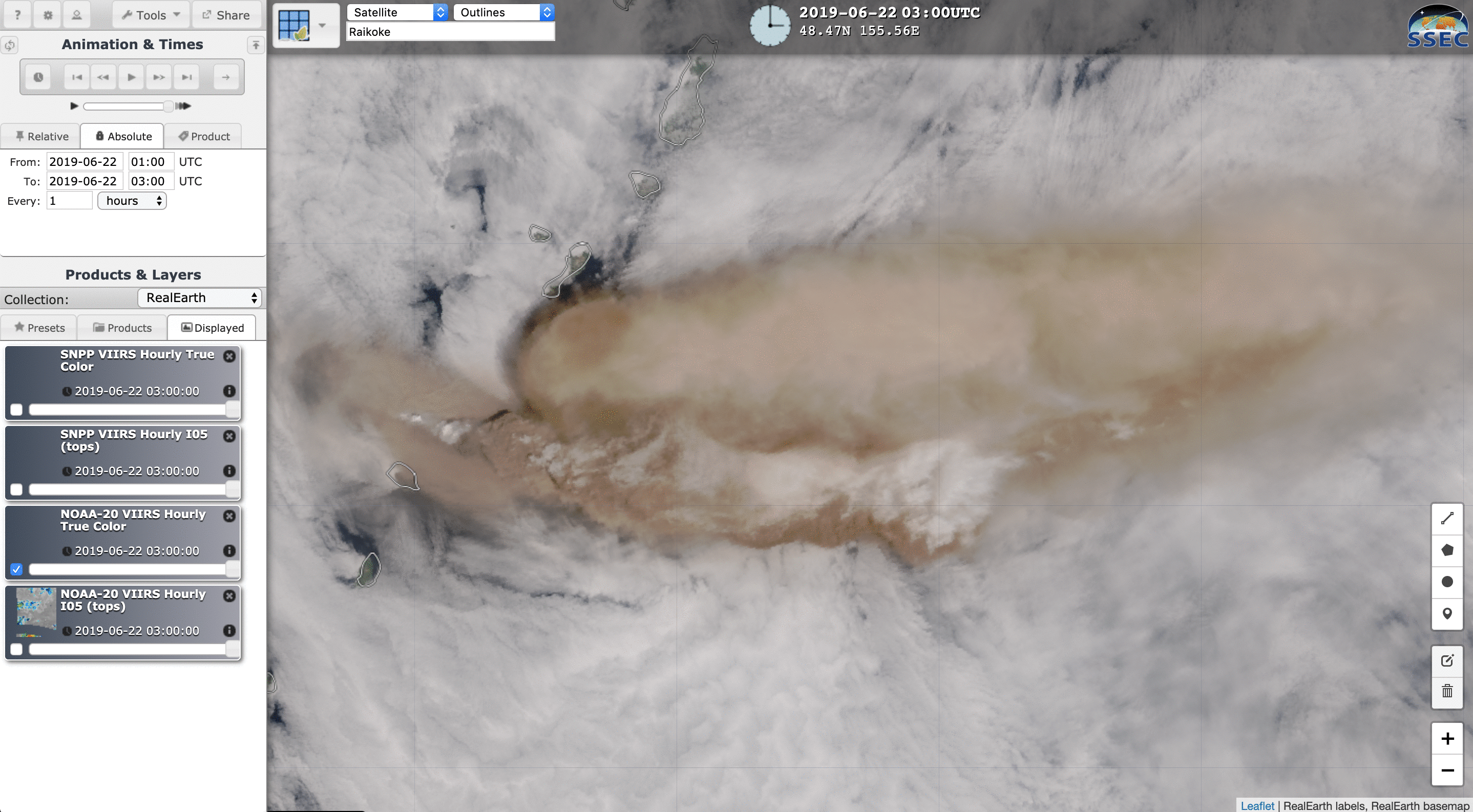
![VIIRS True Color RGB and Infrared Window (11.45 µm) images from NOAA-20 and Suomi NPP [click to enlarge]](https://cimss.ssec.wisc.edu/satellite-blog/wp-content/uploads/sites/5/2019/06/190622_noaa20_suomiNPP_viirs_trueColor_infraredWindow_Raikoke_2_anim.gif)
VIIRS True Color RGB and Infrared Window (11.45 µm) images from NOAA-20 and Suomi NPP at 01, 02 and 03 UTC on 22 June [click to enlarge]

GOES-17 “Red” Visible (0.64 µm) images [click to play animation | MP4]
![NSMC FY-2G Visible (0.73 µm) images [click to play animation | MP4]](https://cimss.ssec.wisc.edu/satellite-blog/wp-content/uploads/sites/5/2019/06/190621_fy2g_visible_Raikoke_anim.gif)
NSMC FY-2G Visible (0.73 µm) images [click to play animation | MP4]

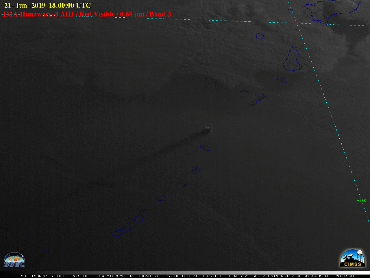
Himawari-8 “Red” Visible (0.64 µm) images [click to play animation | MP4]
?Sound on!
Hear #Raikoke's roar – Himawari satellite imagery of the June 21 #Raikoke #eruption (from @CIMSS_Satellite) with time-synched remote infrasound (from Robin Matoza at @ucsantabarbara) sped-up to be audible to humans. @C_MarieSmith @volcano_diana @CIDER_DeepEarth pic.twitter.com/wdeIZYBkn2— Simon Carn (@simoncarn) June 29, 2019
Incidentally, an astronaut aboard the International Space Station took a photo of the volcanic cloud at 2246 UTC on 21 June — and the two Visible images that bracket that time (2240 and 2250 UTC) from GOES-17 and Himawari-8 are shown below.
![Photo taken by an astronaut on the International Space Station [click to enlarge]](https://eoimages.gsfc.nasa.gov/images/imagerecords/145000/145226/iss059e119250_lrg.jpg)
Photo taken by an astronaut on the International Space Station at 2246 UTC [click to enlarge]
![GOES-17 Visible (0.64 µm) images at 2240 and 2250 UTC {click to enlarge]](https://cimss.ssec.wisc.edu/satellite-blog/wp-content/uploads/sites/5/2019/06/190621_2240utc_2250utc_goes17_visible_Raikoke_anim.gif)
GOES-17 Visible (0.64 µm) images at 2240 and 2250 UTC {click to enlarge]
![Himawari-8 Visible (0.64 µm) images at 2240 and 2250 UTC {click to enlarge]](https://cimss.ssec.wisc.edu/satellite-blog/wp-content/uploads/sites/5/2019/06/190621_2240utc_2250utc_himawari8_visible_Raikoke_anim.gif)
Himawari-8 Visible (0.64 µm) images at 2240 and 2250 UTC {click to enlarge]
===== 23 June Update =====
![Himawari-8 False Color RGB images [click to play MP4 animation]](https://cimss.ssec.wisc.edu/satellite-blog/wp-content/uploads/sites/5/2019/06/190623_18z_himawari8_falsecolor.png)
Himawari-8 False Color RGB images [click to play MP4 animation]
===== 24 June Update =====
![GOES-17 SO2 RGB images [click to play animation | MP4]](https://cimss.ssec.wisc.edu/satellite-blog/wp-content/uploads/sites/5/2019/06/190624_goes17_so2_rgb_AK_anim.gif)
GOES-17 SO2 RGB images [click to play animation | MP4]
![GOES-17 SO2 RGB, Split Clout Top Phase (11.2-8.4 µm) and Dust RGB images, with a pilot report of SO2 [click to enlarge]](https://cimss.ssec.wisc.edu/satellite-blog/wp-content/uploads/sites/5/2019/06/190624_goes17_so2RGB_splitCloudTopPhase_dustRGB_pirep_Raikoke_anim.gif)
GOES-17 SO2 RGB, Split Clout Top Phase (11.2-8.4 µm) and Dust RGB images, with a pilot report of SO2 [click to enlarge]
===== 25 June Update =====
![GOES-17 SO2 RGB images [click to play animation | MP4]](https://cimss.ssec.wisc.edu/satellite-blog/wp-content/uploads/sites/5/2019/06/190625_goes17_so2_rgb_Raikoke_AK_anim.gif)
GOES-17 SO2 RGB images [click to play animation | MP4]
An interesting Pilot Report north of the Aleutians at 36,000 feet (below) noted thin grey-colored layers below the altitude of the aircraft. GOES-17 Air Mass RGB images showed a subtle brown/tan plume — could this have been a thin filament of ash from the Raikoke eruption that was drawn into the circulation of the Bering Sea low?
![GOES-17 SO2 RGB, Air Mass RGB, Dust RGB and Split Cloud Top Phase (11.2-8.4 µm) images, with a 2008 UTC Pilot Report [click to enlarge]](https://cimss.ssec.wisc.edu/satellite-blog/wp-content/uploads/sites/5/2019/06/190625_2010utc_goes17_so2_airmass_dust_splitCloudTopPhase_pirep_AK_anim.gif)
GOES-17 SO2 RGB, Air Mass RGB, Dust RGB and Split Cloud Top Phase (11.2-8.4 µm) images, with a 2008 UTC Pilot Report [click to enlarge]
![GOES-17 SO2 RGB and Split Cloud Top Phase (11.2-8.4 µm) images, with a 2119 UTC Pilot Report [click to enlarge]](https://cimss.ssec.wisc.edu/satellite-blog/wp-content/uploads/sites/5/2019/06/190625_2120utc_goes17_so2_splitCloudTopPhase_pirep_anim.gif)
GOES-17 SO2 RGB and Split Cloud Top Phase (11.2-8.4 µm) images, with a 2119 UTC Pilot Report [click to enlarge]