![Himawari-8 True Color RGB images [click to play animation | MP4]](https://cimss.ssec.wisc.edu/satellite-blog/images/2020/06/Himawari-8_AHI_FLDK_true_color_2020173_073000Z.png)
Himawari-8 True Color RGB images [click to play animation | MP4]
The shadow was also evident in FY-2G Full Disk visible imagery, from the SSEC Geostationary Satellite Imagery site (below).
![]() ![]() |
|
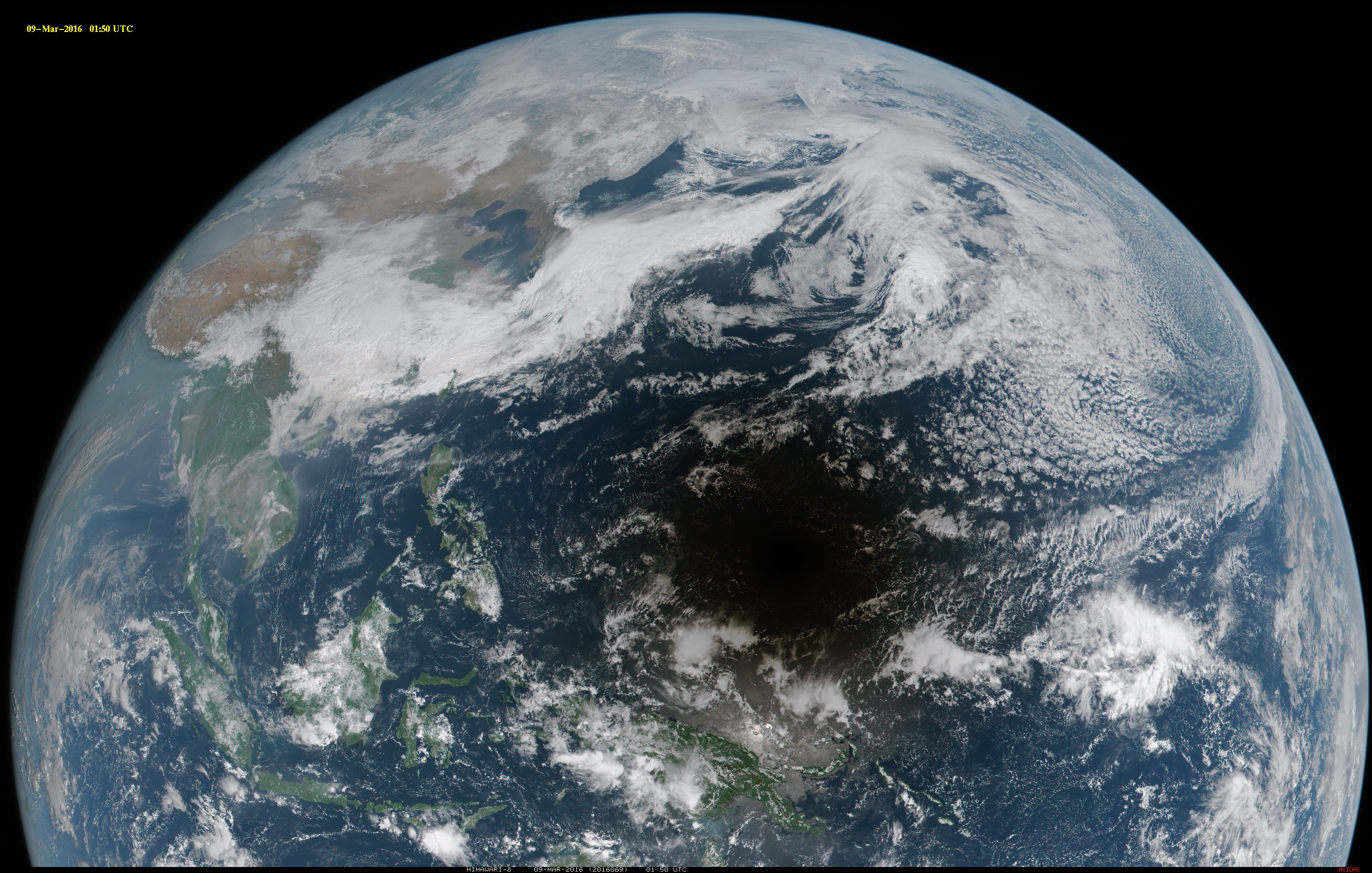
Solstice solar eclipse shadow moving across southern Asia
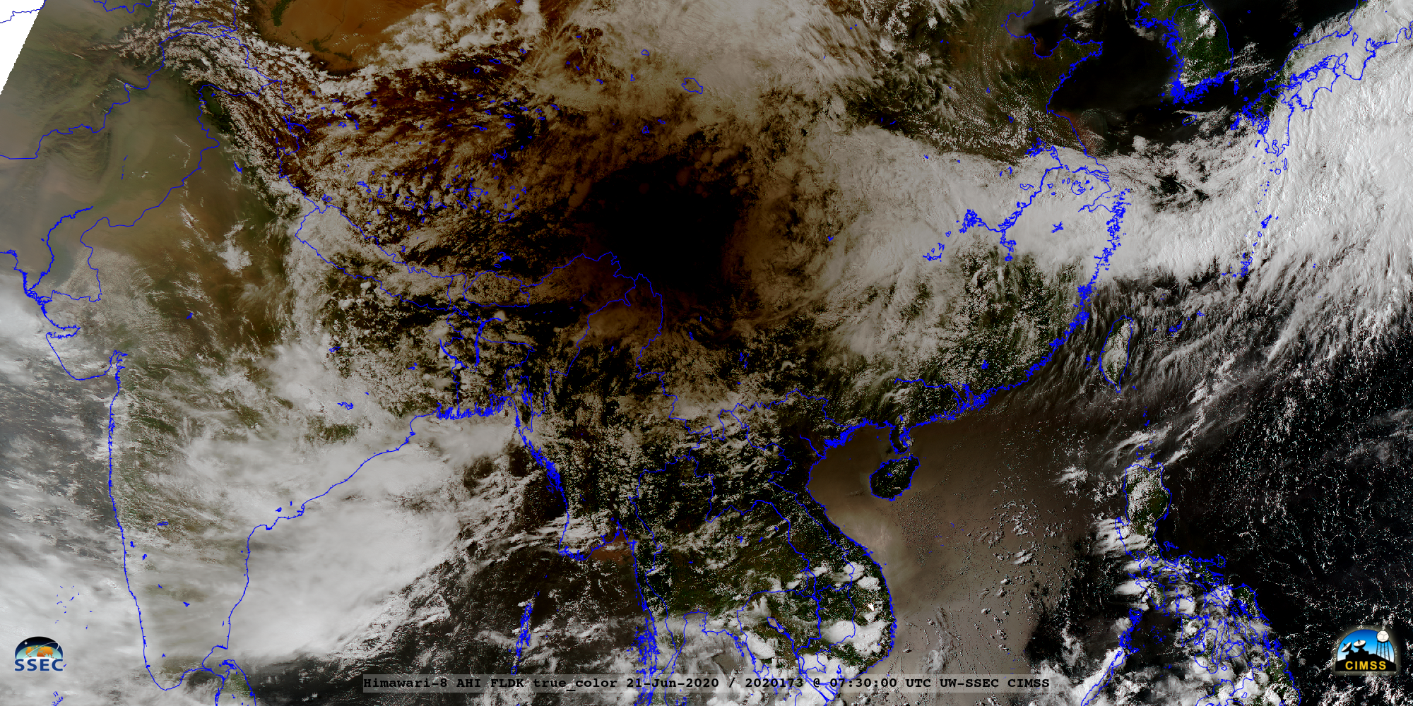
June 21st, 2020 | Scott Bachmeier![]() Himawari-8 True Color RGB images [click to play animation | MP4] The shadow was also evident in FY-2G Full Disk visible imagery, from the SSEC Geostationary Satellite Imagery site (below). Annular solar eclipse shadowDecember 26th, 2019 | Scott BachmeierFull Disk Himawari-8 True Color RGB images (credit: Tim Schmit, NOAA/NESDIS/CIMSS) [click to play animation | MP4] A closer view using images centered over Indonesia is shown below. The small eye of Category 1 Typhoon Phanfone could be seen in the northern portion of the satellite scene. Bright areas of sun glint (south of the eclipse shadow) highlighted regions having light winds — and therefore a relatively flat water surface which behaved like a mirror to reflect a larger amount of sunlight back toward the satellite. Himawari-8 True Color RGB images centered over Indonesia [click to play animation | MP4] FY-2G Visible (0.73 µm) images [click to play animation | MP4] Eruption of the Raikoke volcano in the Kuril IslandsJune 21st, 2019 | Scott Bachmeier![]() Himawari-8 False Color RGB images [click to play animation | MP4] A comparison of an Aqua MODIS False Color RGB image with the corresponding Ash Height, Ash Loading and Ash Effective Radius retrieved products at 0310 UTC on 22 June (below) indicated maximum ash height values of 18-20 km (black pixels) immediately downwind of the eruption site. Maximum Himawari-8 Ash Height values were in the 16-18 km range. ![]() Aqua MODIS False Color RGB image with Ash Height, Ash Loading and Ash Effective Radius retrieved products [click to enlarge] Water Vapor images from Himawari-8: Upper-level (6.2 µm, top), Mid-level (6.9 µm, middle) and Low-level (7.3 µm, bottom) [click to play animation | MP4] Water Vapor images from GOES-17: Upper-level (6.2 µm, top), Mid-level (6.9 µm, middle) and Low-level (7.3 µm, bottom) [click to play animation | MP4] ![]() VIIRS True Color RGB and Infrared Window (11.45 µm) images from NOAA-20 and Suomi NPP at 01, 02 and 03 UTC on 22 June [click to enlarge] GOES-17 “Red” Visible (0.64 µm) images [click to play animation | MP4] NSMC FY-2G Visible (0.73 µm) images [click to play animation | MP4] Himawari-8 “Red” Visible (0.64 µm) images [click to play animation | MP4]
Incidentally, an astronaut aboard the International Space Station took a photo of the volcanic cloud at 2246 UTC on 21 June — and the two Visible images that bracket that time (2240 and 2250 UTC) from GOES-17 and Himawari-8 are shown below. ===== 23 June Update ===== A 2-day animation of 10-minute Himawari-8 False Color images (above) showed the ash- and SO2-rich volcanic plume (brighter shades of yellow) eventually being transported northeastward across the western Aleutian Islands and circulating cyclonically over the Bering Sea. Similarly, this volcanic cloud transport was also seen in the corresponding GOES-17 False Color imagery.===== 24 June Update ===== ![]() GOES-17 SO2 RGB images [click to play animation | MP4] ![]() GOES-17 SO2 RGB, Split Clout Top Phase (11.2-8.4 µm) and Dust RGB images, with a pilot report of SO2 [click to enlarge] ===== 25 June Update ===== ![]() GOES-17 SO2 RGB images [click to play animation | MP4] An interesting Pilot Report north of the Aleutians at 36,000 feet (below) noted thin grey-colored layers below the altitude of the aircraft. GOES-17 Air Mass RGB images showed a subtle brown/tan plume — could this have been a thin filament of ash from the Raikoke eruption that was drawn into the circulation of the Bering Sea low? Another Pilot Report farther to the west at 2119 UTC (below) was close to the southern edge of the GOES-17 SO2 signatures, but no sulphur odor was reported; however, they did note the presence of an apparent ash layer south of Shemya in the western Aleutian Islands.Solar eclipse shadow as seen from geostationary satellitesMarch 9th, 2016 | Scott Bachmeier
The shadow of the total solar eclipse of 09 March 2016 was captured by a number of geostationary satellites, including JMA Himawari-8 (above; also available as either a large 140 Mbyte animated GIF, or a YouTube video: large) | small) and KMA COMS-1 (below). The Himawari-8 true-color Red/Green/Blue (RGB) images were created using the Simple Hybrid Contrast Stretch (SHCS) method by Yasuhiko Sumida, SSEC visiting scientist from JMA.
Toward the end of the eclipse, the shadow was also seen with NOAA GOES-15 (below) as it moved northwest and north of Hawai’i. In addition, the eclipse shadow was captured with the Chinese satellites FY-2E and FY-2G (below). |
|