GLM archived gridded products at the GRHC DAAC.
GOES Calibration
NOAA STAR GOES-East/West calibration page including cal and nav. Plus a Cal Event Log
CIMSS Imagery 16-band; times difference images 16-panel of the ABI at both CONUS and Full Disk for GOES-East and GOES-West
GOES ABI Geo-Geo Comparisons for regions from both the FD and CONUS sectors
GOES Spectral Response functions Plots and files: GOES-16/17/18/19 and other GOES; plus Planck coefficents; Also from the CWG.
GOES ABI Clear-sky Weighting functions both static and realtime. You Tube training video
GOES Eclipse Schedules from OSPO
ABI Times Series from UW/CIMSS
GOES ABI Data
NOAA CLASS (GRABIPRD) for GOES ABI radiances and imagery Need to register. More info
and Video on how to access
GOES-R Series Data in the NOAA Open Data Dissemination (NODD) Program (formerly Big Data Project) -including derived products also at AWS and the Explore Bucket (G19) or Explore Bucket (G18)
Google Cloud Platform for GOES-16 ABI
Google Cloud Platform for GOES-17 ABI
Google Cloud Platform for GOES-18 ABI
Google Cloud Platform for GOES-19 ABI
OCC Environmental Data Commons for GOES data.
UNIDATA: Publically Accessible McIDAS ADDE servers (LEAD.UNIDATA.UCAR.EDU)
SSEC Satellite Data Services Inventory (UW-Madison)
GEONETCast Americas, and a blog part of GEONETCast.
GOES Space Weather
GOES-R Series Space Weather Data
GOES SUVI imagery from the Space Weather Prediction Center (SWPC).
GOES-East SUVI imagery from a DIY GRB receiving system by @wxstar3000 and @H_Neil and a SUVI daily RGB maker. (2020-05-15) & (2020-05-29) & (2021-10-27)
GOES-East SUVI RGB maker from GOES-West RGB maker and static cases: (2024-04-08) or (2024-05-08) or (2024-05-14)
GOES-East SUVI imagery including RGBs, from the Space Science and Engineering Center (SSEC).
GOES-West SUVI imagery including RGBs, from the Space Science and Engineering Center (SSEC).
GOES-16 SUVI First Light RGB-maker small and large.
GOES-17 SUVI First Light RGB-maker (Preliminary, non-operational)
More Space Weather info or SUVI
Cool GOES-16 SUVI animations Full Solar rotation and Large solar flare and Partial Solar Eclipse
Other Space Weather Instruments on the GOES-R Series (Data and software via NCEI)
(Free) Software
McIDAS-V (UW Madison)
SIFT--Satellite Information Familiarization Tool (UW Madison) More info
Python notebook displaying ABI data from @blaylockbk
SSEC's HYDRA (use single or multi band CMIP files) Most recent version of the code
GOES-16 Manipulation Tools from GNC-A
Manipulating GOES-16 with GDAL from the OCC
NCview a netCDF visual (quicklook) browser
CSPP Geo Community Satellite Processing Package for Geostationary Data Geo2Grid Software Package
Integrated Data Viewer (IDV) (UNIDATA)
Panoply from NASA Goddard.
Pytroll GOES-16 ABI: Example
ImageJ image manipulation.
Software for Manipulating/Displaying NetCDF Data list from UNIDATA.
Weather and Climate Toolkit (WCT) from NOAA/NCEI.
Coast Watch software from NOAA CoastWatch.
Beginner's Guide to GOES-R Series Data Resources compiled by Danielle Losos, GOES-R Product Readiness and Operations
Google Earth Engine: CIMSS "True" Color multi-band example (2 km) and Level 2 Fire/Hot Spot Characterization by D. Losos and K. Schwehr.
Python to download/process GOES ABI via AWS from @blaylockbk and some RGBs in python.
Glance toolkit to compare two netcdf and generate a report from UW/SSEC.
(Free) Phone apps
SSEC GOES ABI app: iOS and Android
Real Earth apps
WxSat Android
MapSat (CPTEC/INPE) iOS
MapSat (CPTEC/INPE) Android
GOES-R/16 ABI Training / Education
GOES-R Education Proving Ground and GOES-R Series Countdown Calendar for Educators
CIMSS Education Webapps ABI Links to: ABI Matching webapp game and Parallax and Seasons webapps
Match Image Pairs webapp for photos and GOES satellite imagery: Oregon or Lake Superior
Match Image Pairs webapp for ABI bands(8): ABI ABI or 16-bands: over Mexico or South America or South America
Fall 2017: GOES-R Series Virtual Course ABI
GOES Virtual Science Fair for middle school, high school and grades 13/14 (community college or university)
GOES-R/16 Fact Sheets (quick guides) with both pre-launch and post-launch data. Thanks to ECCC, ABI band fact sheets in French
More GOES-R/16 Fact Sheets (quick guides)
SHyMet Course Info (videos)
CIMSS Satellite Blog: GOES-16 and GOES-17 and GOES-18 and GOES-19
CIRA Loop of the Day
CIMSS GOES-R Fog Products Blog
GOES-R VISIT Foundational Course
Satellite Liaison Blog
GOES East and Roof Top Cameras (UW / AOS / SSEC in Madison, WI)
Satellite Training and Operations Resources (STOR)
on NOAA's VLab
You Tube training video on Weighting Functions and You Tube training video on spectral-temporal fusion
VISIT training webinars and Basic ABI operations
Satellite Met Resources by @DrKimWood at Mississippi State University
Satellite Book Club presentation on Augmenting RGB w Derived Product Readouts by B. Line T. Schmit, NOAA/NESDIS (You Tube)
GOES-16/17/18 ABI Info
GOES-R Program the GOES-R Series Data Book and the GOES-R Series Book, including space wx (Elsevier)
GOES-R Docs F&PS, ATBDs, PUGs, etc. ABI File name conventions
NESDIS home page and the
Product Quality overview page.
GOES-R/16 tweets and GOES-S/17 tweets and GOES-T/18 tweets
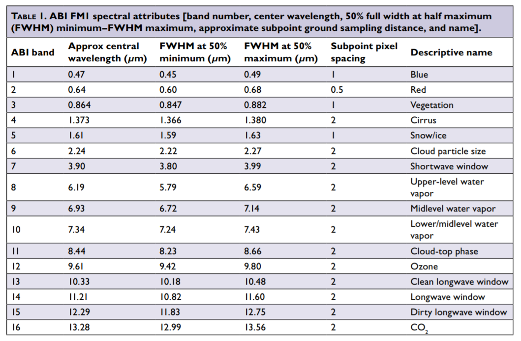
Pre-launch BAMS article on the ABI including ABI Band Table and ABI Guide
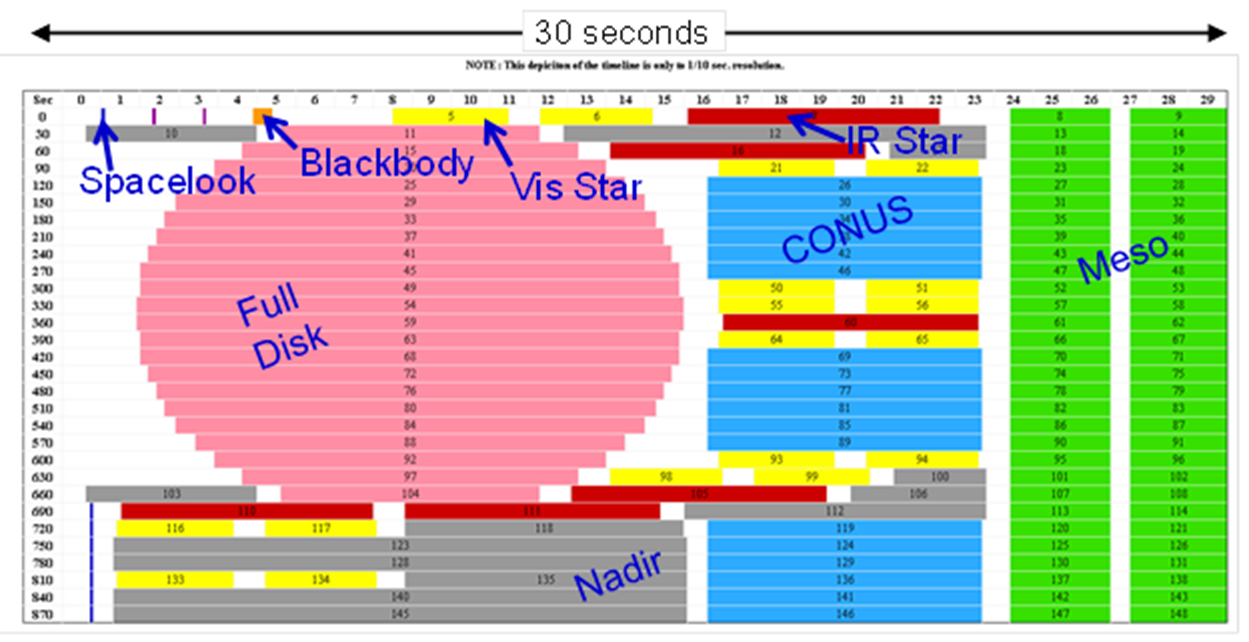
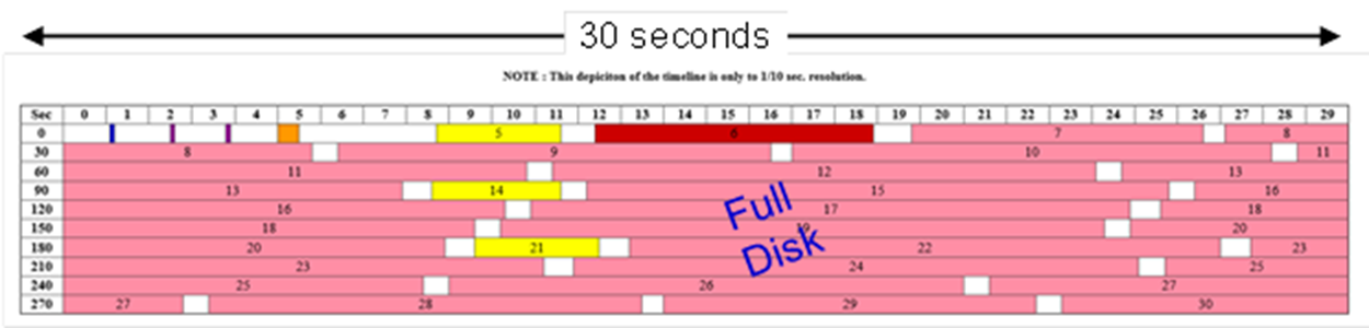
ABI Mode 3 "cooling" timeline (G-17 only certain times) Mode Mode 3 (flex) Mode 4 (CFD) GOES-16 Mode 6a (w 10-min FD) GOES-17 Mode 6m (w 10-min FD)
Post-launch NWA JOM article on the ABI including ABI Band Table
Photons to Pixels article on the ABI
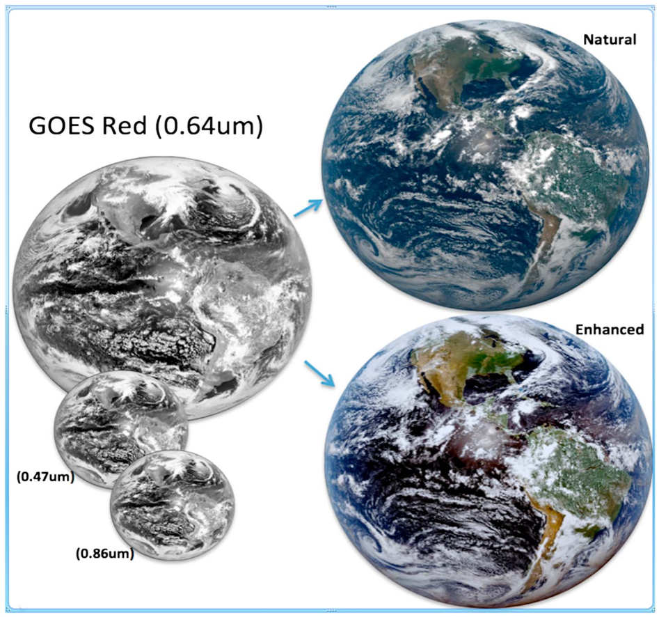
Generation of GOES-16 True Color Imagery
without a Green Band in AGU's Earth and Space Science, including this figure
GOES-R Series Publications List
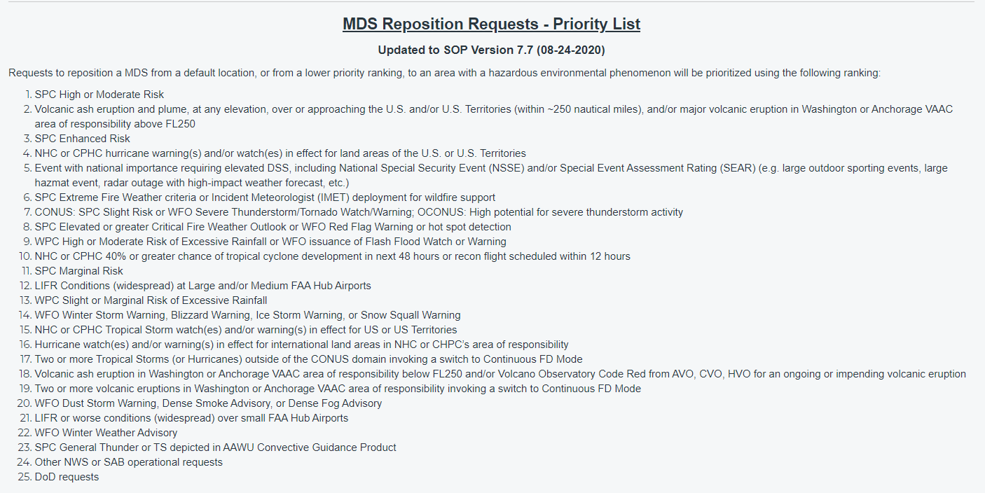
Recent / Planned ABI Meso-scale locations GOES Contacts e.g., email: SPSD.UserServices@noaa.gov and the meso-sector reposition priority list. NCO.
ABI Meso-scale locations over the last year and more from the SSEC Data center the last year and more for GOES-East
ABI Meso-scale location search function from the SSEC Data center for GOES-East and -West over their operational lifetimes
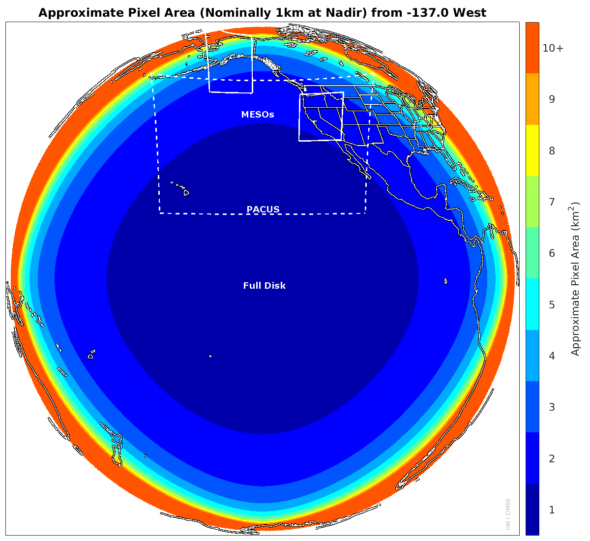
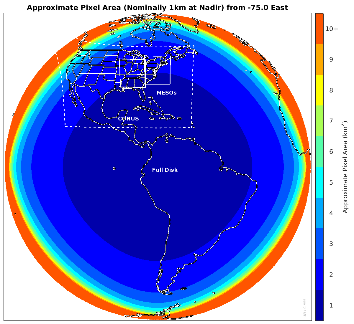
GOES-East and GOES-West Meso-scale preview location tool from CIRA; Default coverage/pixel size plots, West and East from CIMSS
Special Bulletins/ General Messages regarding NOAA's satellite operations.
GRB ABI Schedules and HRIT ABI Schedules from NOAA's satellite operations and contacts and Mesoscale Research Request form
How to DIY and aquire HRIT and other signals by @carlreinemann
SSEC ABI Monitoring page
Big Ten Network on Geo Wx Satellites and 2017: Wednesday Nite at the Lab seminar on GOES-16 and 2022: Wisconsin's Role in Earth Imaging from Geostationary Orbit, 1966-2022
Top 25 ABI Animations from GOES-16 and Top 25 ABI Animations from GOES-17 including looking back at 2022.
Beginner's Guide to GOES-R Series Data Resources compiled by Danielle Losos, GOES-R Product Readiness and Operations
Level 2 -- Derived Products, etc.
NOAA NCEI's Archive Information Request System (AIRS) Clouds (ACHA for cloud heights, LST, SST, TPW, etc
NOAA CLASS's NDE: Fog and Low Stratus (Note a different file naming convention)
GOES-R Series Level 2 Data in the NOAA Big Data Project - now call NOAA Open Data Dissemination (including derived products (standard L2 naming convention))
GOES-R Series Cloud Product Evaluation (GOES-16/18 and other sensors) and RealEarth
"Soundings" Validation Tool TPW, stability parameters, etc (GOES-16 etc.)
NOAA/CIMSS Volcanic Cloud Monitoring Web Portal Both LEO and GEO imagery (research)
NOAA/CIMSS ProbSevere: a statistical model that predicts the probability that a storm will produce severe weather in the near-term (research)
Aerosol Watch from NOAA STAR
GOES ABI Derived winds from NOAA STAR
GOES ABI Derived Land Surface Temperature (LST) from NOAA STAR
Amazon AWS (and OCC) GOES Level 2 data fetcher from @blaylockbk
CIMSS experimental turbulence product
Weather and Climate Toolkit (WCT) from NOAA/NCEI to view L2 products.
ProbSevere LightningCast model uses GOES ABI data to predict the probability of lightning in the next 60 minutes from NOAA/STAR and UW/CIMSS.
ALIVE Estimating terrestrial carbon dioxide uptake in real time from a geostationary platform.
Misc: ABI Level 0 (Raw Data) and DCS
CLASS archive and the PUG Volume 2 (Level 0 data intended for expert users).
DCS (Data Collection System) and the DCS history.
JMA's AHI (Western Pacific, Eastern Asia, Australia, etc.) Imagery
AHI links including RGB quick guides
KMA's AMI (Western Pacific, Eastern Asia, Australia, etc.) Imagery and Products
Imagery and RGB composites and Derived products from the AMI on GK2A operated by KMA
For another satellite resources page from the Eastern Region NWS
For a similar page for JPSS, created and maintainted by Scott Lindstrom, UW-Madison SSEC. Or a weather page by Robert Rabin, NSSL, including Alaska, Baffin Island and NW coast of Hudson Bay.
The data, products, and imagery available on these websites are intended for informational purposes only. Neither the websites nor the data displayed herein are considered operational, and should not be used to support operational observation, forecasting, emergency, or other disaster mitigation or response operations, either public or private.
The upkeep of these links by Tim Schmit is a best effort basis only. Mostly only links for free imagery/software are included. A similar GOES resource page, curated by NOAA NESDIS STAR. Information on the GeoXO satellite system for which plans include a hyperspectral infrared sounder.
To suggest needed updates: E-Mail
Contact Form
| | | | | | | | | | | 