This website works best with a newer web browser such as Chrome, Firefox, Safari or Microsoft Edge. Internet Explorer is not supported by this website.

GOES-13 is the operational GOES-East satellite once again

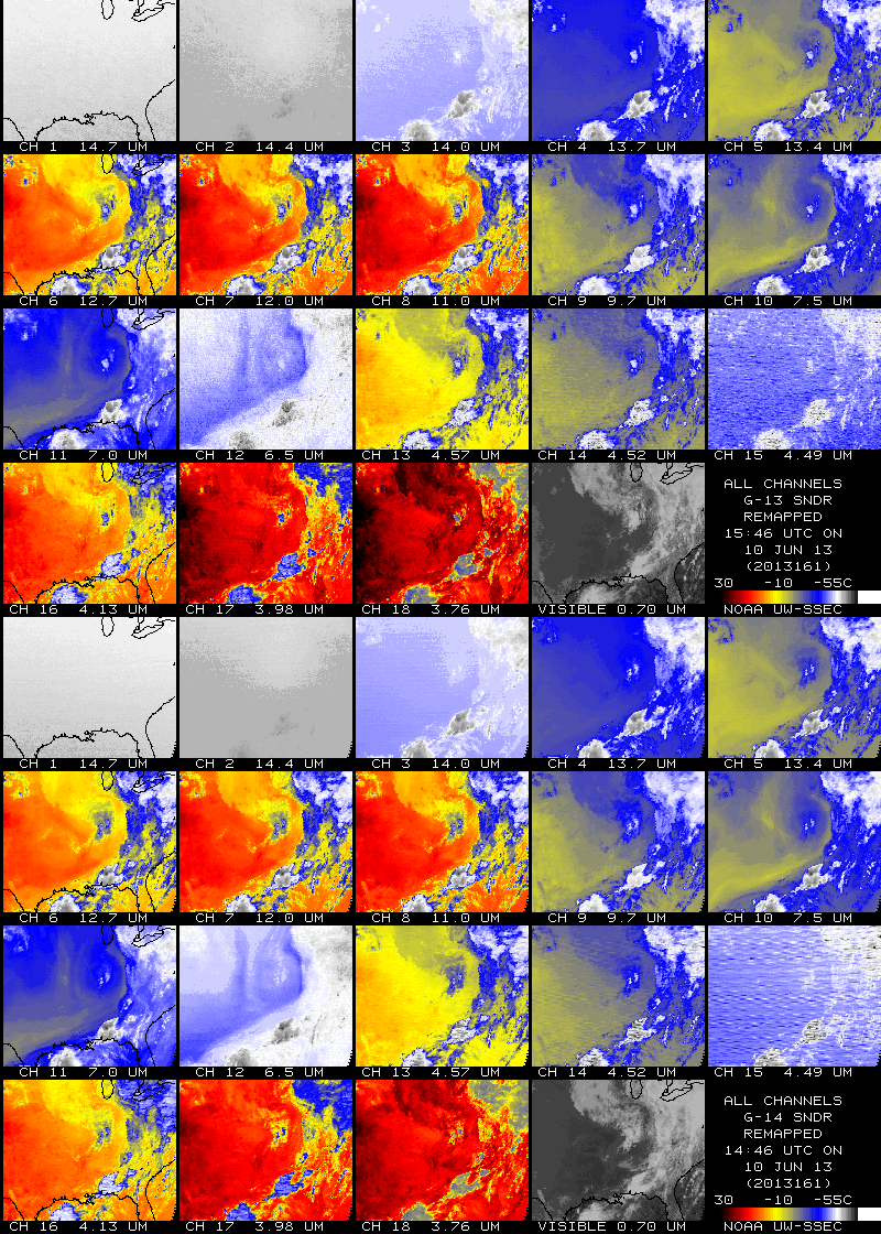
GOES-13 became the operational GOES-East satellite once again at 15:45 UTC on 10 June 2013 (following recovery from an anomaly on 22 May) — the multi-panel image above shows all 19 bands of the GOES-13 Sounder along with all 5 bands of the GOES-13 Imager... Read More

19 bands of the GOES-13 Sounder (upper panels) and 5 bands of the GOES-13 Imager (lower panels)

19 bands of the GOES-13 Sounder (upper panels) and 5 bands of the GOES-13 Imager (lower panels)

GOES-13 became the operational GOES-East satellite once again at 15:45 UTC on 10 June 2013 (following recovery from an anomaly on 22 May) — the multi-panel image above shows all 19 bands of the GOES-13 Sounder along with all 5 bands of the GOES-13 Imager at that time.

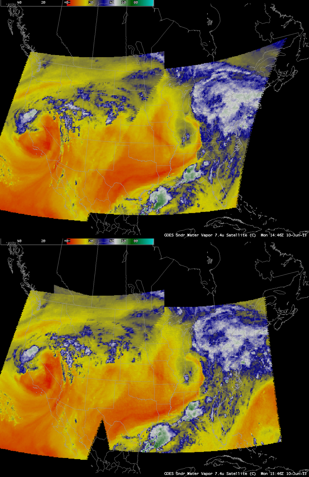
The images below show the GOES Sounder 7.4 µm water vapor channel data using AWIPS, and the footprint change from GOES-14 at 14:46 UTC to GOES-13 at 15:46 UTC is obvious.

GOES-West and GOES-East Sounder 7.4 µm water vapor channel

GOES-West and GOES-East Sounder 7.4 µm water vapor channel

A comparison of all 19 bands of the Sounder instrument on GOES-14 and GOES-13 (below) shows some improvement in noise in a few of the bands (due to an “outgas” procedure being performed on the GOES-13 Sounder during recovery from the anomaly).

Comparison of the 19 Sounder bands on GOES-14 (14:46 UTC) and GOES-13 (15:46 UTC)

Comparison of the 19 Sounder bands on GOES-14 (14:46 UTC) and GOES-13 (15:46 UTC)

=============================================
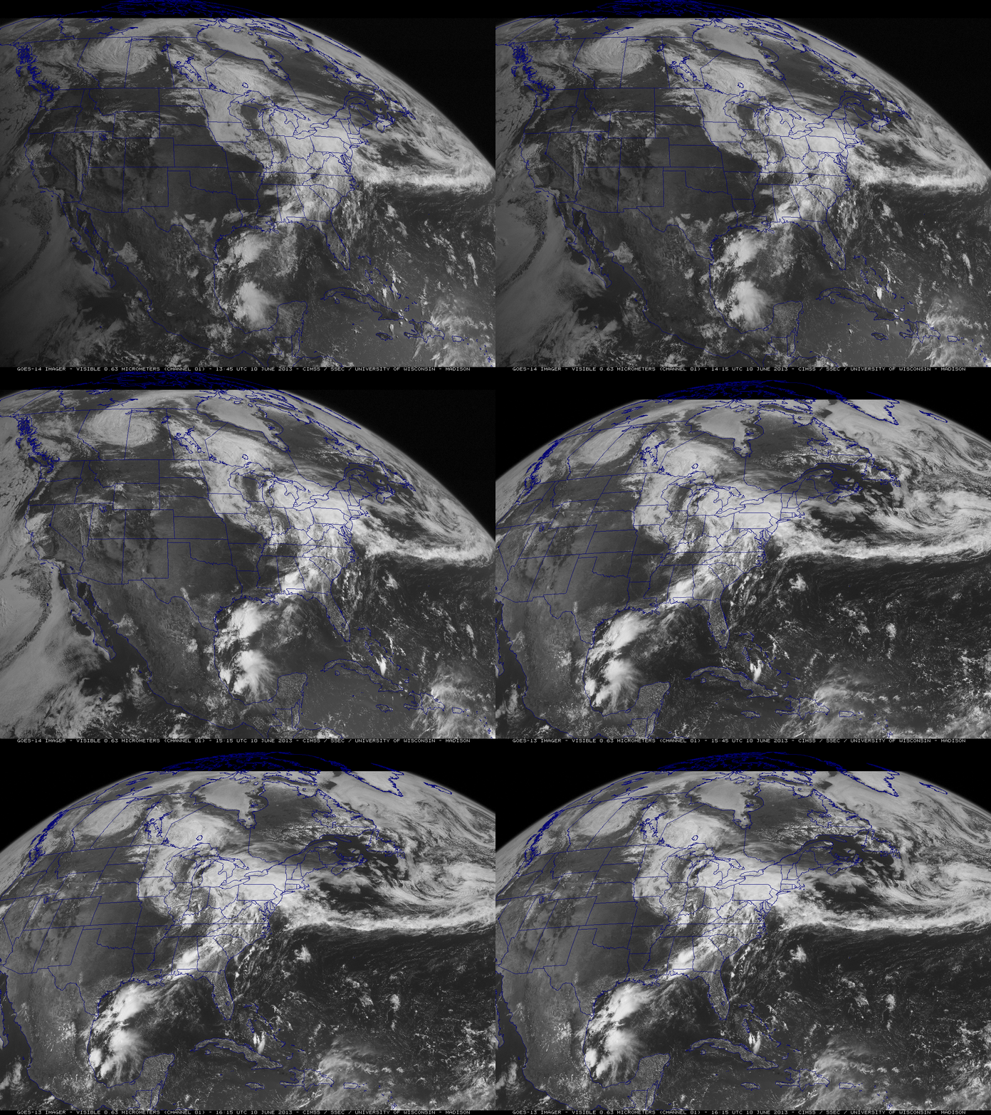
The transition from GOES-14 to GOES-13, as seen in 0.63 µm visible channel data from the Imager instrument

The transition from GOES-14 to GOES-13, as seen in 0.63 µm visible channel data from the Imager instrument

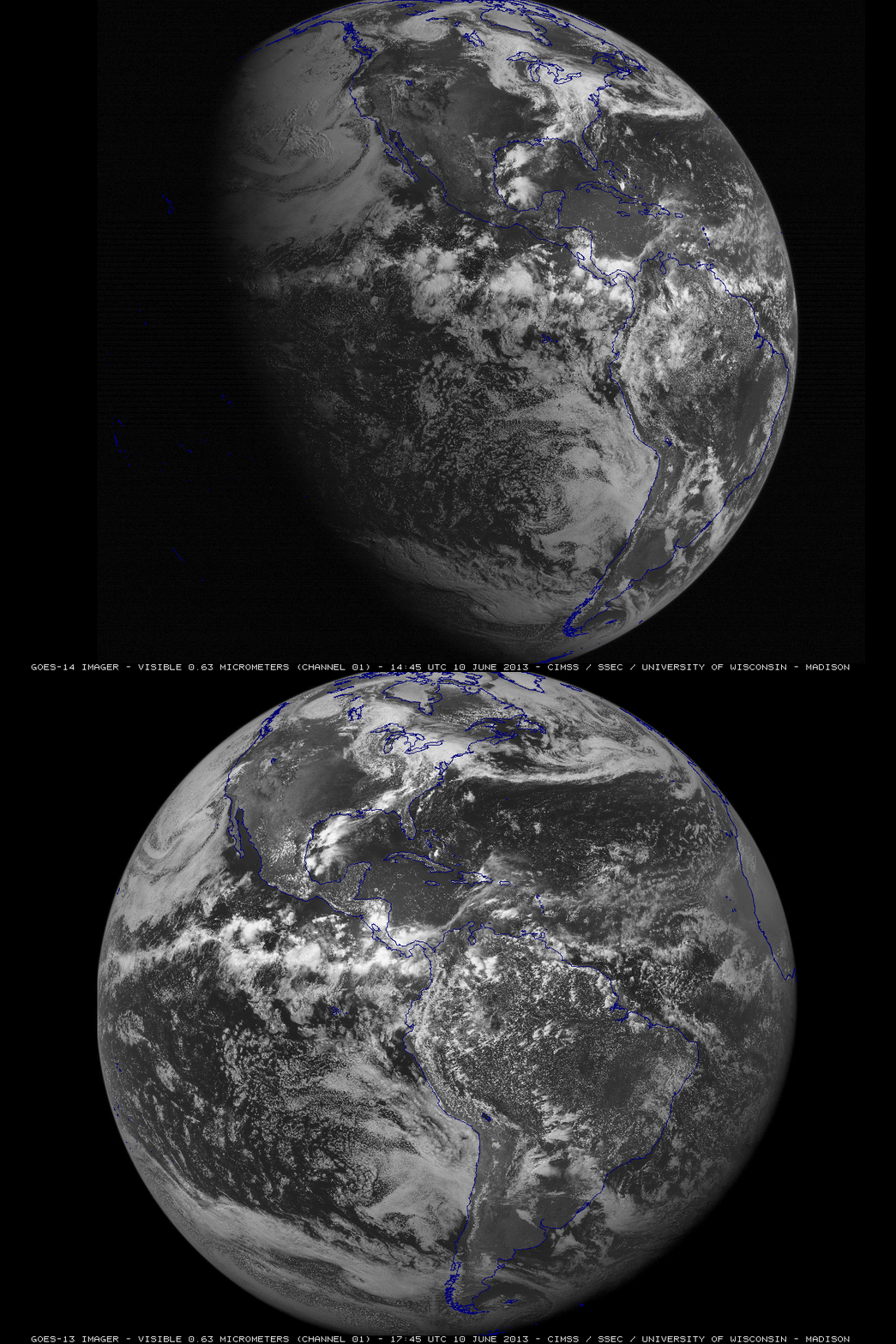
The transition from GOES-14 to GOES-13 is also shown above, using McIDAS images of 0.63 µm visible channel data from the Imager instrument. Once again, the image perspective is different, due to the fact that GOES-14 is positioned over the Equator at 105 W longitude, and GOES-13 is at 75 West longitude. This difference in satellite viewing perspective is very apparent when comparing the Full Disk views of 0.63 µm visible channel images from GOES-14 at 14:45 UTC and GOES-13 at 17:45 UTC (below).

GOES-14 vs GOES-13 Full Disk 0.63 µm visible channel images

GOES-14 vs GOES-13 Full Disk 0.63 µm visible channel images

View only this post Read Less
Unusually dry cut-off low near the southern California coast

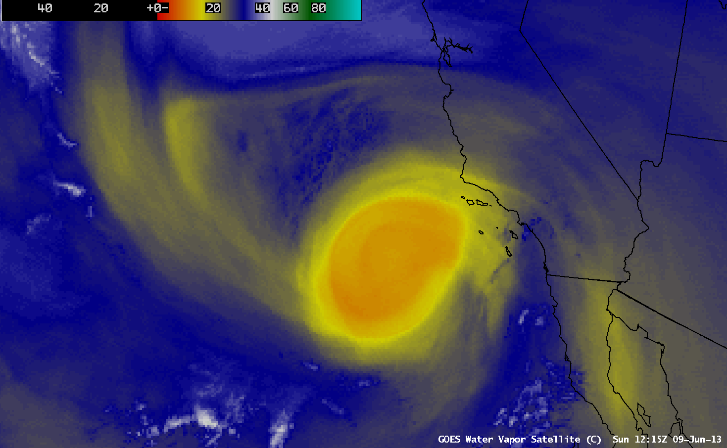
AWIPS images of GOES-15 6.5 µm water vapor channel data (above; click image to play animation) showed the formation of an unusually dry signature associated with a cut-off low near the coast of southern California during the 08 JuneRead More

GOES-15 6.5 µm water vapor channel images (click image to play animation)

GOES-15 6.5 µm water vapor channel images (click image to play animation)

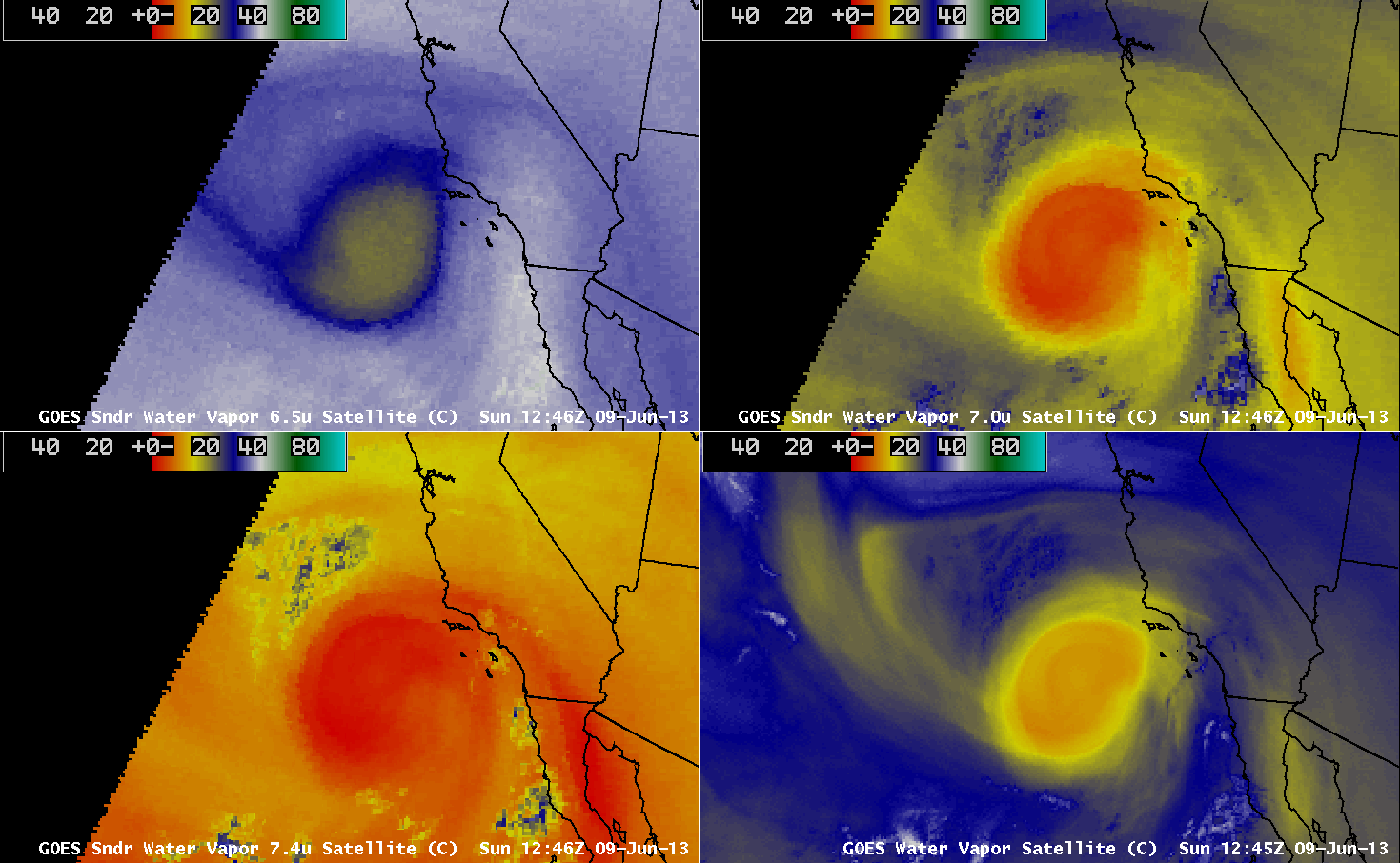
AWIPS images of GOES-15 6.5 µm water vapor channel data (above; click image to play animation) showed the formation of an unusually dry signature associated with a cut-off low near the coast of southern California during the 08 June09 June 2013 period. Water vapor channel brightness temperatures were as warm as -9.0º C (darker orange color enhancement), which is an abnormally warm/dry value to be seen on water vapor imagery.

This warm/dry signal was also very apparent on imagery from the 3 water vapor channels (6.5 µm, 7.0 µm, and 7.4 µm) that are available from the GOES-15 sounder (below; click image to play animation). These 3 GOES sounder water vapor channels sense the amount of mosture within 3 different vertical layers of the atmosphere, and are used to create the GOES sounder Total Precipitable Water (TPW) derived product — which in this case depicted TPW values as low as 11 mm or 0.43 inch at 18:00 UTC. The Blended Total Precipitable Water Percent of Normal product indicated that the TPW values within the dry cut-off low were generally 40-70% of normal for this time of year over that region.

GOES-15 Sounder and Imager water vapor channel images (click mage to play animation)

GOES-15 Sounder and Imager water vapor channel images (click mage to play animation)

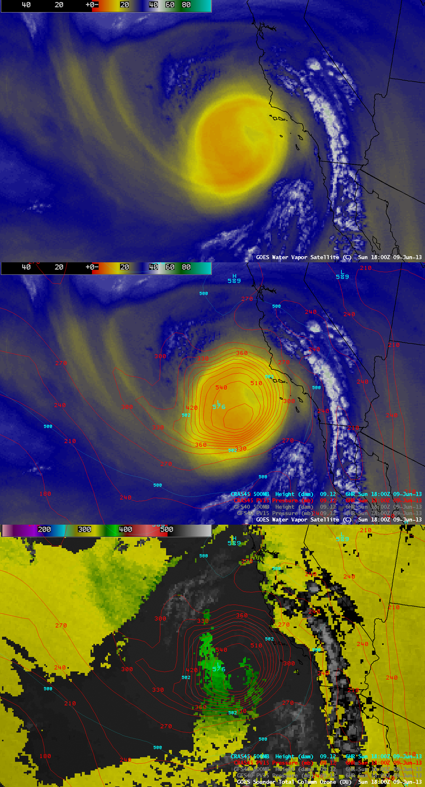
The very warm/dry signature seen on the GOES-15 water vapor imagery was well-correlated with elevated values of GOES-15 sounder Total Column Ozone, which suggests an abnormally low tropopause within that feature. This was verified with fields from the CRAS model, which indicated that the height of the dynamic tropopause (taken to be the PV1.5 surface) was as low as the 570 hPa pressure level at 18:00 UTC. GOES sounder Total Column Ozone values were as high as 382 Dobson Units within the dry cut-off low.

GOES-15 imager 6.5 µm water vapor channel image + GOES-15 sounder Total Column Ozone product (with overlays of CRAS model fields)

GOES-15 imager 6.5 µm water vapor channel image + GOES-15 sounder Total Column Ozone product (with overlays of CRAS model fields)

===== 10 June Update =====

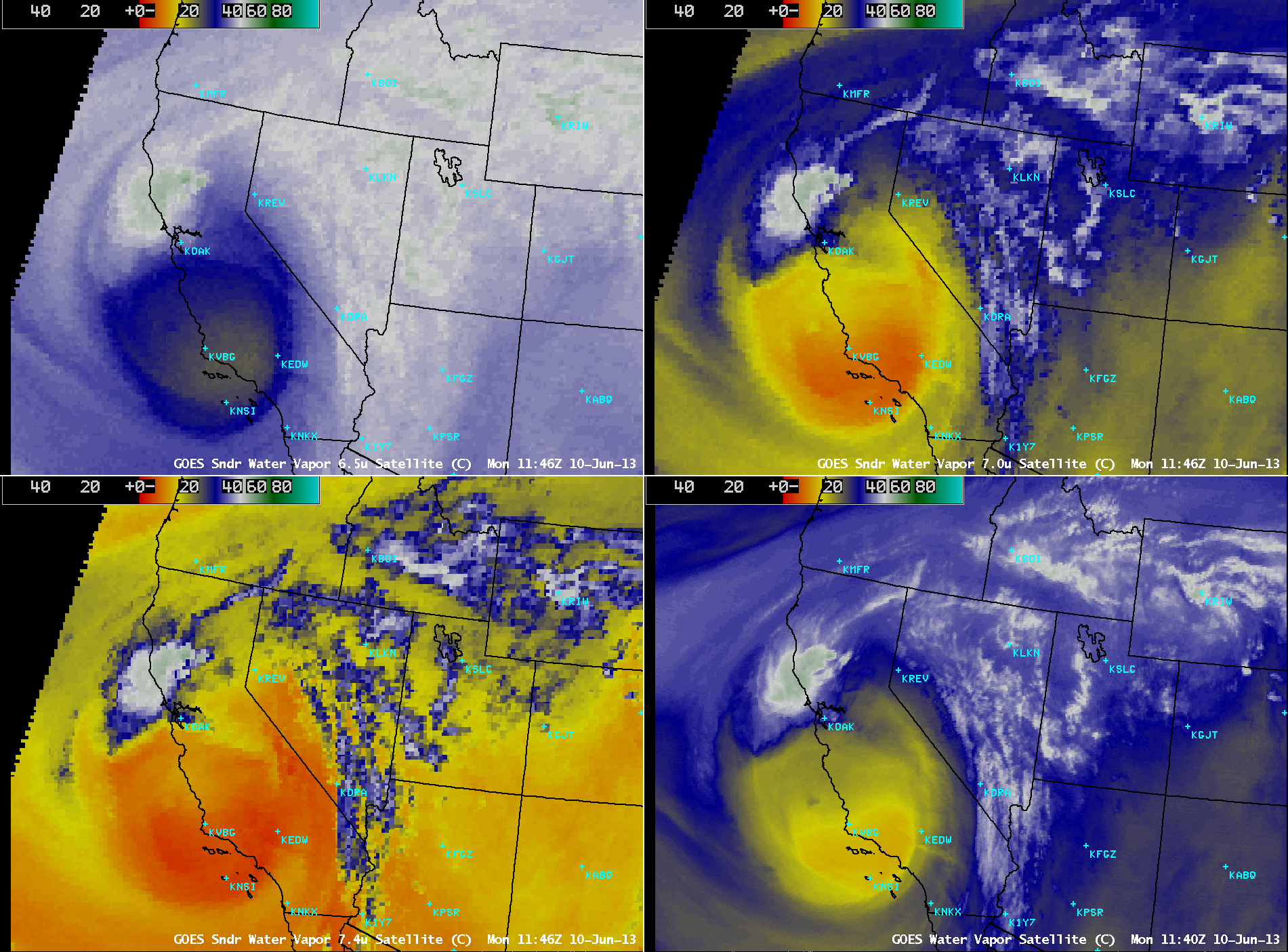
Comparison of GOES-15 Sounder and Imager water vapor channel data

Comparison of GOES-15 Sounder and Imager water vapor channel data

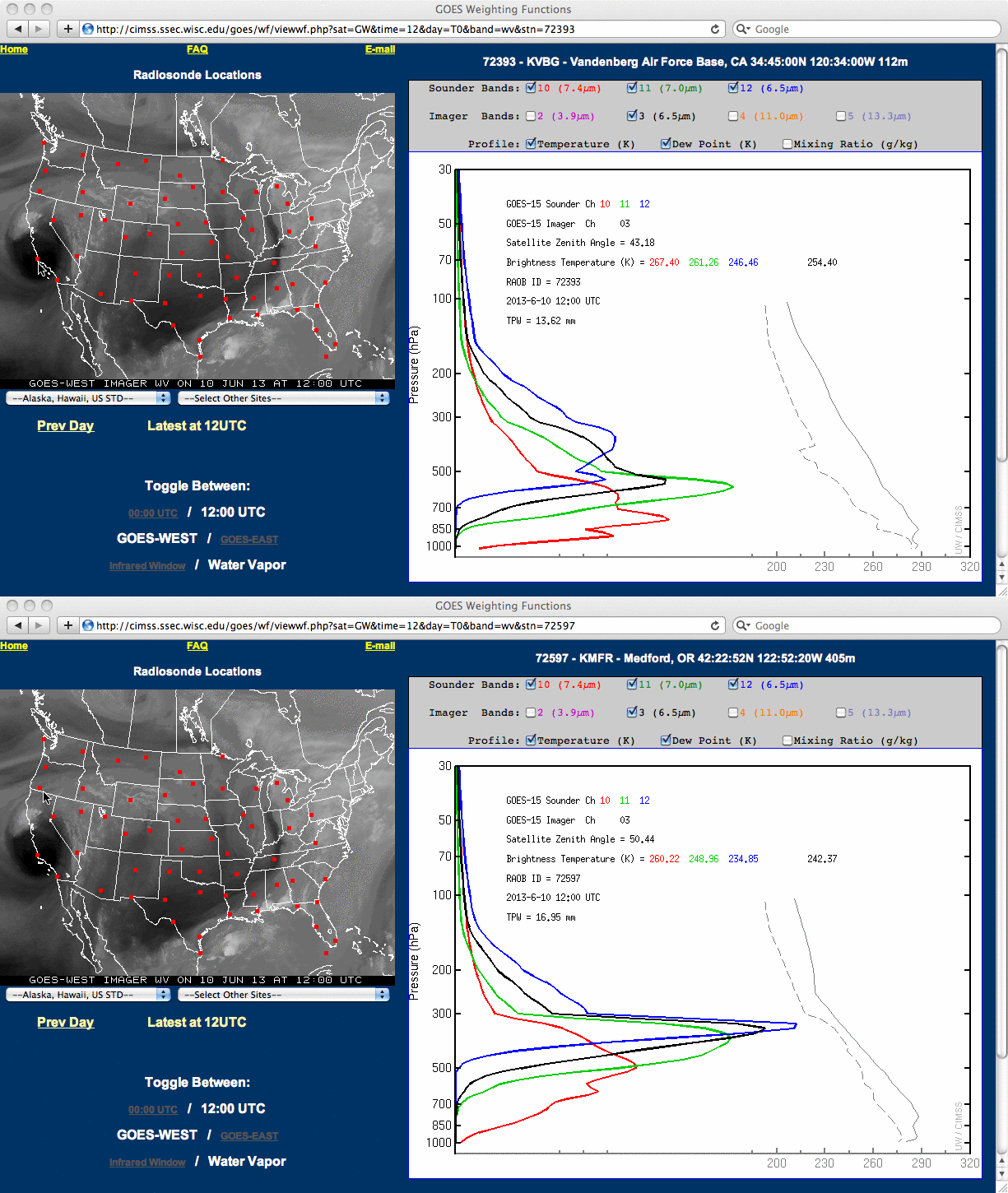
The dry cut-off low began to move inland over southern California on 10 June, and an AWIPS image comparison of GOES-15 Sounder and Imager water vapor channel data (above) showed that it was centered approximately over Vandenberg Air Force Base (KVBG) at around 12 UTC that morning. A comparison of the GOES-15 Sounder and Imager water vapor channel weighting functions (below) indicated that the individual water vapor channels were sensing radiation from layers that were at much lower altitudes in the dry air mass over Vandenberg, California than they were farther to the north over Medford, Oregon (KMFR) where the atmosphere had much more moisture distributed within the middle to upper troposphere.

Comparison og GOES-15 Sounder and Imager water vapor channel weighting function plots

Comparison og GOES-15 Sounder and Imager water vapor channel weighting function plots

View only this post Read Less
Tropical Storm Andrea

Tropical Storm Andrea (the first Atlantic Basin tropical cyclone of the 2013 season) formed in the eastern Gulf of Mexico on 05 June 2013. GOES-14 10.7 µm IR images from the Read More

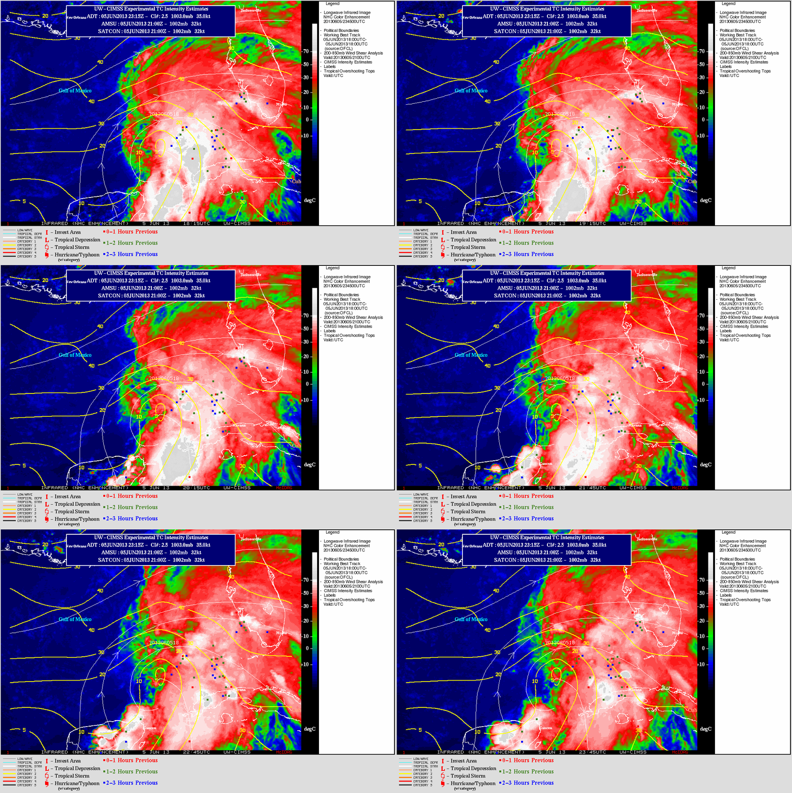
GOES-14 10.7 µm IR images + wind shear and tropical overshooting tops

GOES-14 10.7 µm IR images + wind shear and tropical overshooting tops

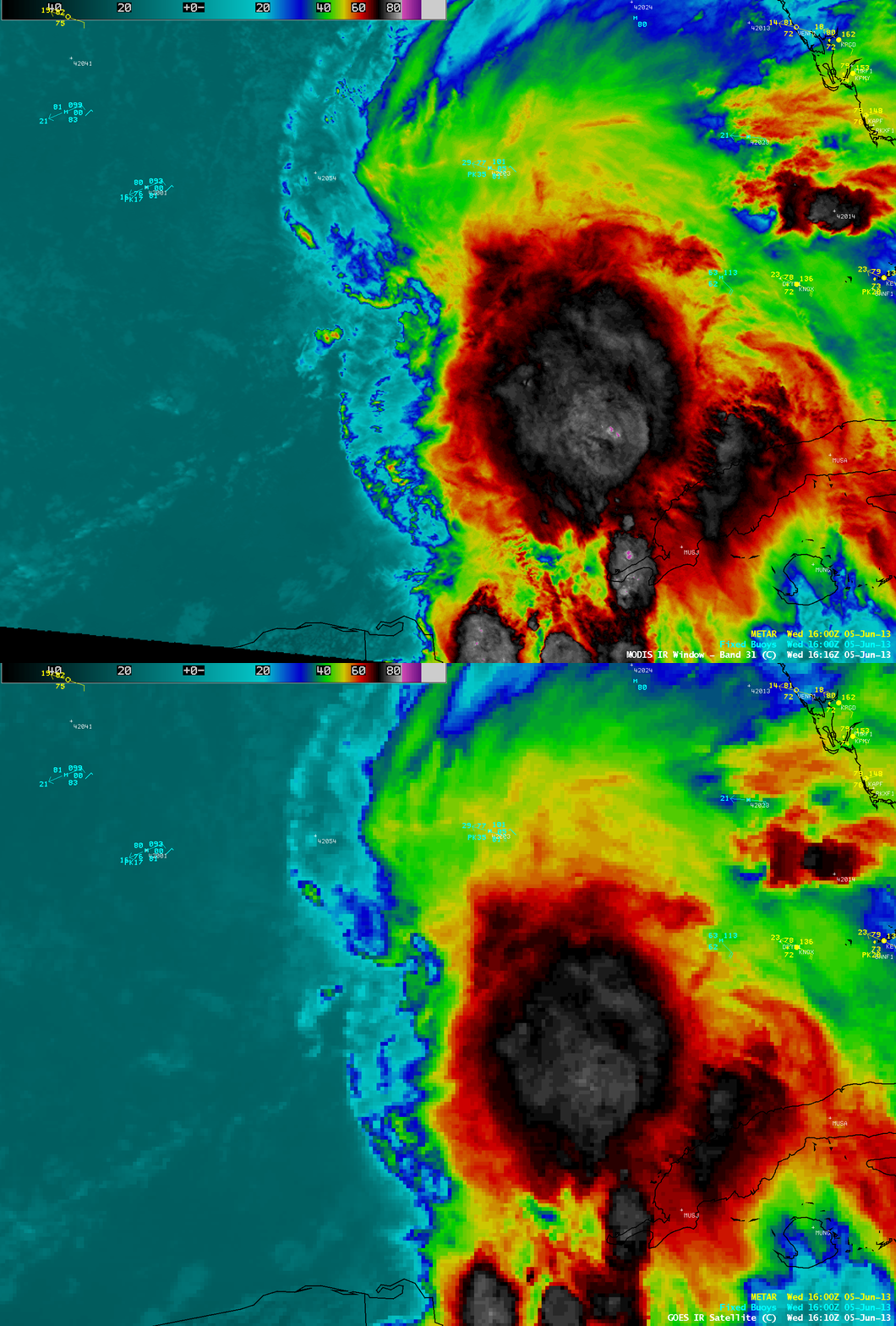
Tropical Storm Andrea (the first Atlantic Basin tropical cyclone of the 2013 season) formed in the eastern Gulf of Mexico on 05 June 2013. GOES-14 10.7 µm IR images from the CIMSS Tropical Cyclones site (above) showed that the center of Andrea was located along the western edge of deep convection, which exhibited numerous Tropical Overshooting Tops. Andrea was forecast to move northeastward into an environment characterized by increasing values of deep layer wind shear, so rapid intensification was not anticipated.

Due to partial obscuration by high clouds from the deep convection, the low-level center of circulation was difficult to identify on McIDAS images of GOES-14 0.63 µm visible channel data (below; click image to play animation).

GOES-14 0.63 µm visible channel images (click image to play animation)

GOES-14 0.63 µm visible channel images (click image to play animation)

Early in the day, an AWIPS comparison of 1-km resolution MODIS 11.0 µm IR and 4-km resolution GOES-14 10.7 µm IR images (below) demonstrated that the higher spatial resolution data was able to display the small yet very cold areas of tropical overshooting tops — the coldest IR brightness temperatures seen on the MODIS image were -87º C (violet color enhancement), compared to -78º C (lighter gray color enhancement) on the corresponding GOES-14 IR image.

MODIS 11.0 µm IR channel and GOES-14 10.7 µm IR channel images

MODIS 11.0 µm IR channel and GOES-14 10.7 µm IR channel images

===== 06 June Update =====

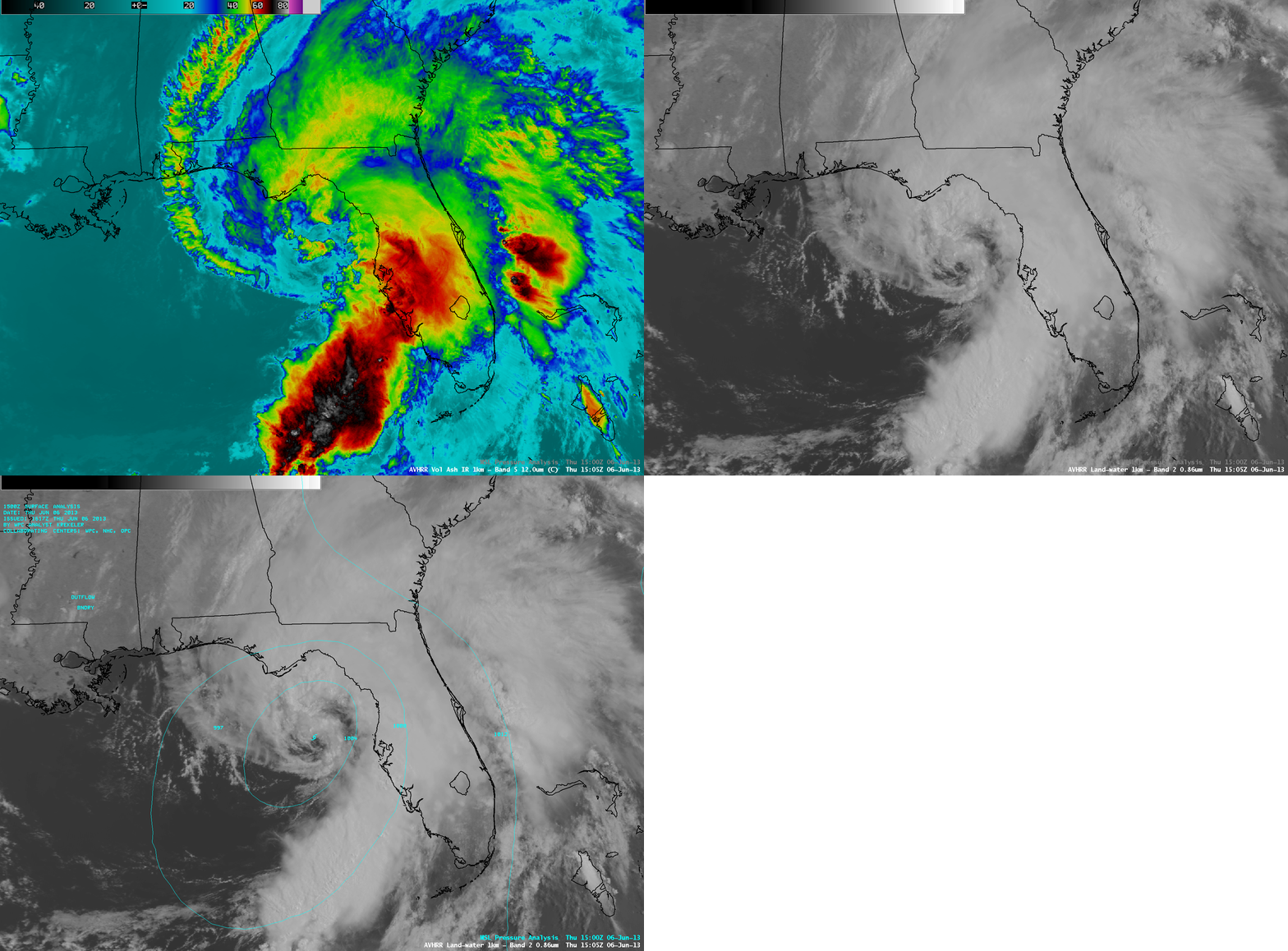
POES AVHRR 12.0 µm IR channel and 0.85 µm visible channel images

POES AVHRR 12.0 µm IR channel and 0.85 µm visible channel images

1-km resolution POES AVHRR 12.0 µm IR channel and 0.86 µm visible channel images (above) showed Andrea off the west coast of Florida at 15:05 UTC. There was some suggestion of a closed eye beginning to form on the visible image.

1-km resolution GOES-14 0.63 µm visible channel images (below; click image to play animation) revealed that the center of circulation became more well-defined as the tropical storm made landfall around 21:40 UTC (5:40 PM local time) near Steinhatchee, Florida. Maximum sustained winds at landfall were estimated to be 65 mph.

GOES-14 0.63 µm visible channel images (click image to play animation)

GOES-14 0.63 µm visible channel images (click image to play animation)

View only this post Read Less
Update on GOES-13

Special update: GOES-13 is scheduled to become the operational GOES-East on June 6, 2013 at approximately 1545 UTC. Link.Special update #2:GOES-13 will become the operational GOES-East Satellite no sooner than Monday 10 June 2013 Link.GOES-13 will become operational GOES-East at approximately 1545 UTC on Monday June 10. Link.(Update on the... Read More

Special update: GOES-13 is scheduled to become the operational GOES-East on June 6, 2013 at approximately 1545 UTC. Link.

Special update #2:GOES-13 will become the operational GOES-East Satellite no sooner than Monday 10 June 2013 Link.

GOES-13 will become operational GOES-East at approximately 1545 UTC on Monday June 10. Link.

(Update on the GOES-13 Sounder can be found at the bottom of the blog post)

GOES-13 Imager Channels from 1445 UTC on 3 June 2013 (click image to play animation)

GOES-13 Imager Channels from 1445 UTC on 3 June 2013 (click image to play animation)

GOES-13 suffered an anomaly in May, and GOES-14 has been standing in for GOES-13 since May 23rd. (Click here to read about a possible cause of the anomaly) Testing of GOES-13 has shown that the Imager continues to send quality imagery, as shown in the animation of Full-Disk imagery above.

GOES-13 and GOES-14 6.5 µm Sounder Channels from 1346 UTC on 31 May 2013

GOES-13 and GOES-14 6.5 µm Sounder Channels from 1346 UTC on 31 May 2013

The Sounder, at present, is being outgassed (and there is therefore no current Sounder data; the sounder is off during outgassing); it is possible that after outgassing, the GOES-13 imagery will be as clean as GOES-14. Imagery before outgassing showed significant differences in noise levels between the two instruments. An outgas was also performed last year to reduce noise in the sounder observations (that outgas was of shorter duration).

GOES-14 10.7 µm Imager showing change in CONUS sector footprint

GOES-14 10.7 µm Imager showing change in CONUS sector footprint

GOES-14 remains the operational GOES-East image until further notice. The CONUS sector has been expanded to the east to include Puerto Rico in more operational scans. Imagery above shows the coverage before and after the eastward expansion of the CONUS sector.

NOAA/NESDIS continues distributing updates on the GOES satellites. Announcements can also be found here.

Update: June 6 2013:

GOES-13 4.4 µm Sounder from before (top) and after (bottom) outgassing.  Standard deviation of imagery as shown

GOES-13 4.4 µm Sounder from before (top) and after (bottom) outgassing. Standard deviation of imagery as shown

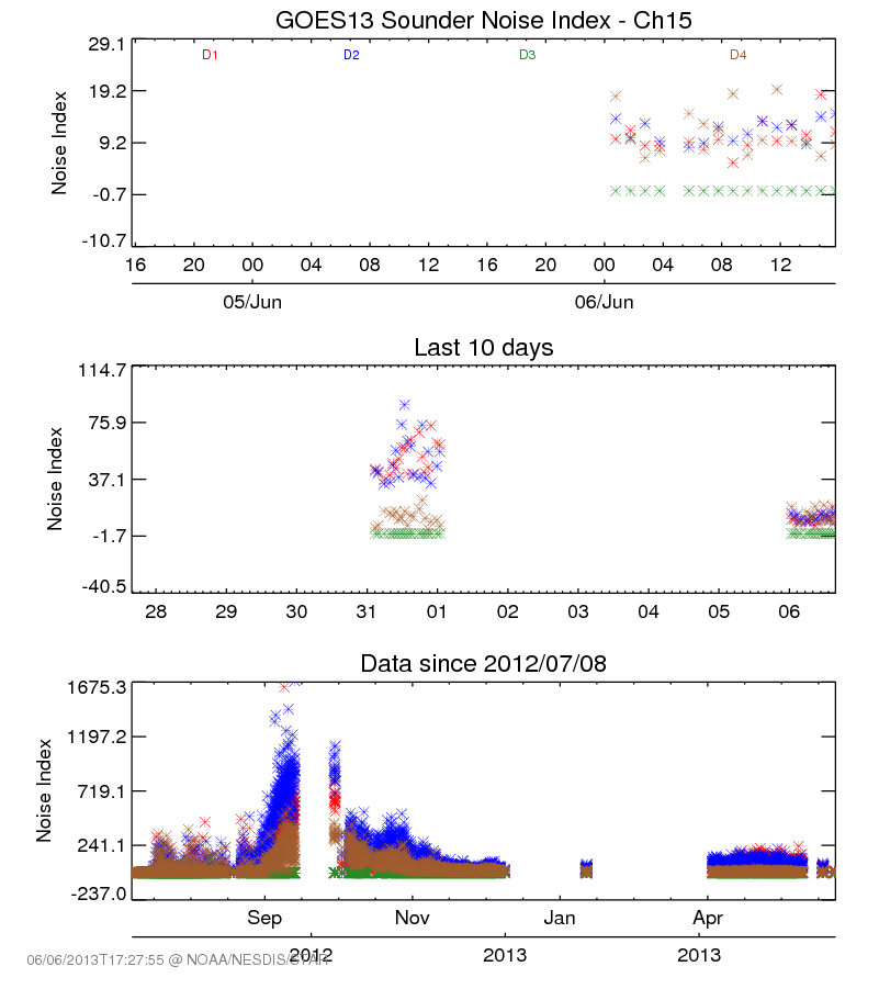
An outgas was performed to “clean” the sounder instrument, and it was successful. Above are images from Sounder band 15 (4.4 µm) before (top) and after (bottom) the outgas. Note that the standard deviation of the image has dropped. The Noise Index in the figure below (from this website) also shows a dramatic change for the better after the outgas. (Image below courtesy of Fangfang Yu, NOAA/NESDIS).

Noise Index from GOES-13 4.4 µm Sounder channel from various timeframes

Noise Index from GOES-13 4.4 µm Sounder channel from various timeframes

View only this post Read Less