Noise in the Shortwave GOES-13 Sounder Channels
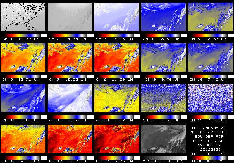
The shortwave infrared channels on the GOES-13 sounder have displayed increasing amounts of noise over the past months. The multi-channel display, above, shows distinct noise in the channels at 4.57 µm, 4.53 µm, 4.45 µm and 4.13 µm. Animations of the GOES-13/GOES-15 imagery from AWIPS shows that the noise is far more obvious in the GOES-13 channel. It is especially noteworthy in the 4.45 µm channel (called the 4.5 µm channel in AWIPS) but also readily apparent in the 4.13 µm channel (called the 4.0 µm channel in AWIPS).
Data from these noisy channels are used in the computation of derived products. The effect of the noise is manifest as small-scale noise in the derived fields of total precipitable water, for example, and the bad data is most noticeable at night, because the shortwave data are used to identify cloudy pixels; during the day, visible imagery identifies cloudy pixels. Thus, maps of, for example, lifted index have too many pixels flagged as cloudy at night compared to during the day. Also compare the 0600 UTC Total Precipitable Water (TPW) image to the 1900 UTC image.
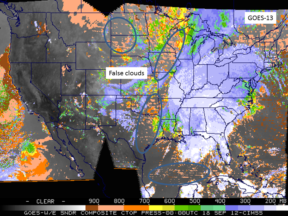
Because the shortwave data are used to identify cloudy pixels, night-time estimates of cloud-top pressure as also impacted, as shown above. The GOES-13 Sounder-derived cloud-top pressure includes several regions that are indicated as cloudy because of the noisy shortwave data. A similar field derived from GOES-14 sounder data does not include the cloudy pixels. Data from 1800 UTC — when visible imagery can be used to screen out clear pixels with more efficacy — shows less contamination that can be traced to the shortwave fields. That is, the fields derived from the GOES-13 and GOES-14 Sounder look more similar.
NESDIS scientists are evaluating how the shortwave bands can be excluded from the GOES-13 Sounder computation to reduce night-time noise in the output fields. Real-time GOES Sounder imagery is available at this link. Derived products, including Convective Available Potential Energy (CAPE), TPW, Lifted Index and cloud-top properties can also be viewed at that link.
(Some imagery in this blog post courtesy of Tim Schmit, NOAA/NESDIS)
This plot, courtesy of Mat Gunshor, CIMSS, shows the standard deviation of the difference between observed brightness temperature and forward-calculated brightness temperatuers. A big jump in noise occurred in late August.


