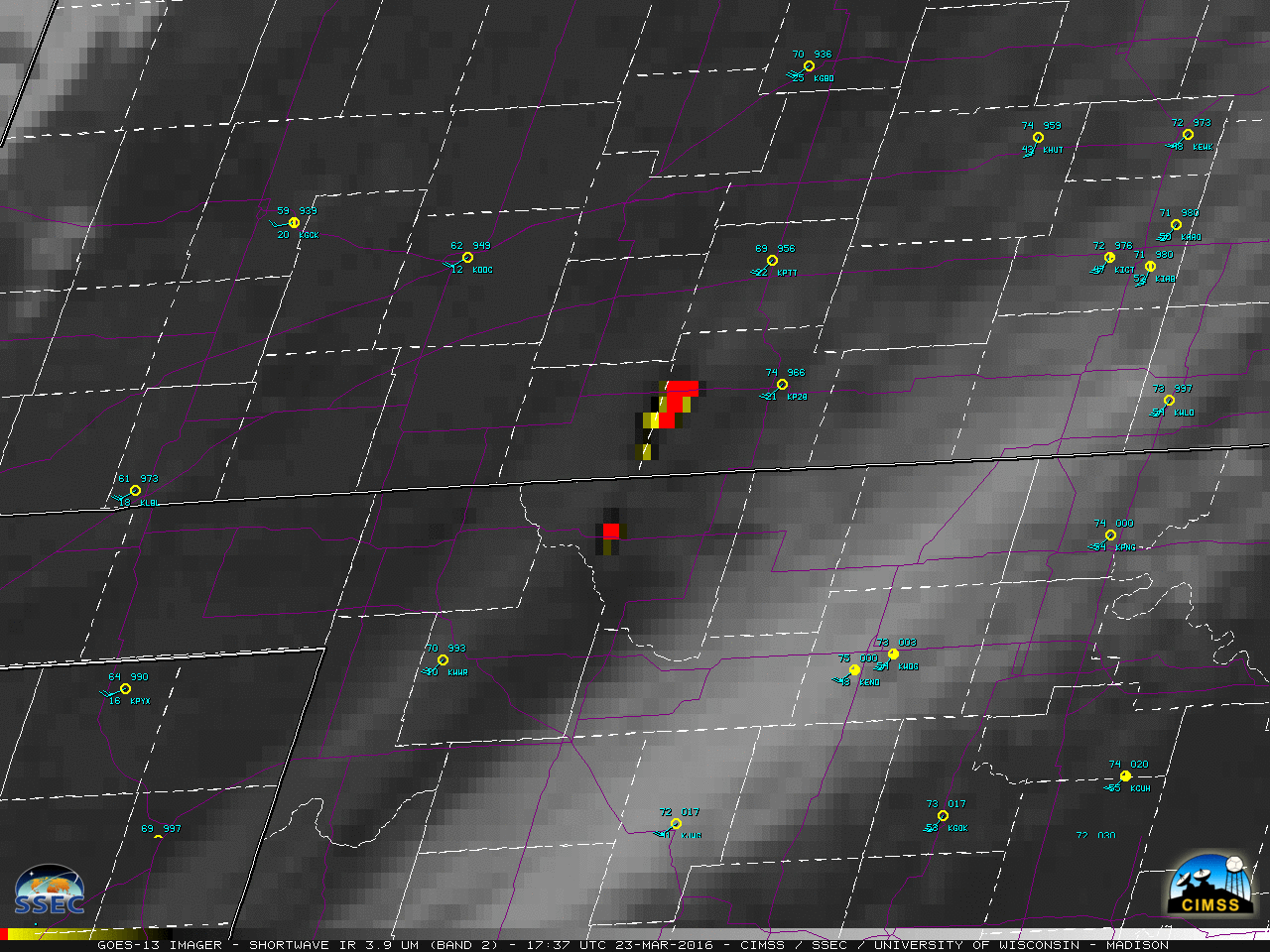
A grass fire (now referred to as the “Anderson Creek fire”) was first reported in western Woods County, Oklahoma around 2245 UTC or 5:45 PM local time on 22 March 2016. “Hot spot” signatures (yellow to red to black pixels) on GOES-13 Shortwave Infrared (3.9 µm) images (above) showed that the fire... Read More
![GOES-13 Shortwave Infrared (3.9 µm) images, with surface reports [click to play animation]](https://cimss.ssec.wisc.edu/satellite-blog/wp-content/uploads/sites/5/2016/03/960x1280_AGOES13_B2_GOES13_SWIR_OK_KS_FIRE_22MAR_2016083_173700_0001PANEL.GIF)
GOES-13 Shortwave Infrared (3.9 µm) images, with surface reports [click to play animation]
A grass fire (now referred to as the “Anderson Creek fire”) was first reported in western Woods County, Oklahoma around 2245 UTC or 5:45 PM local time on
22 March 2016. “Hot spot” signatures
(yellow to red to black pixels) on GOES-13 Shortwave Infrared (3.9 µm) images
(above) showed that the fire proceeded to make a very fast run to the north during the overnight hours, crossing over the Kansas border into Comanche and Barber Counties. The fire eventually jumped Highway 160 — which runs west-to-east across the northern portion of those 2 counties (highways are plotted in violet) — forcing it to be closed for several hours. As of the afternoon of 23 March, the fire was reported to have burned at least 72,000 acres; on that evening, the mayor of Medicine Lodge, Kansas
(station identifier KP28) called for a
voluntary evacuation as the fire began to approach the edge of the town. Note that GOES-13
(GOES-East) had been placed into Rapid Scan Operations (RSO) mode specifically to monitor the
extremely critical fire risk, and was providing images as frequently as every 5-7 minutes.
A nighttime comparison of Suomi NPP VIIRS Day/Night Band (0.7 µm) and Shortwave Infrared (3.74 µm) images at 0823 UTC or 3:23 AM local time (below) showed the hot spots and the bright glow of the large and very hot fire.
![Suomi NPP VIIRS Day/Night Band (0.7 µm) and Shortwave Infrared (3.74 µm) images {click to enlarge]](https://cimss.ssec.wisc.edu/satellite-blog/wp-content/uploads/sites/5/2016/03/160323_0823utc_suomi_npp_viirs_DayNightBand_ShortwaveIR_OK_KS_Camp_Houston_fire_anim.gif)
Suomi NPP VIIRS Day/Night Band (0.7 µm) and Shortwave Infrared (3.74 µm) images {click to enlarge]
A sequence of Shortwave Infrared images from POES AVHRR, Terra/Aqua MODIS, and Suomi NPP VIIRS (below) provided higher-resolution snapshots of the rapid northward progression of the fire during the overnight hours (aided by strong southerly winds), followed by an east/northeastward expansion during the subsequent daylight hours (driven by a switch to strong southwesterly winds after the passage of a dryline).
![POES AVHRR (3.7 µm), Terra/Aqua MODIS (3.7 µm), and Suomi NPP VIIRS (3.74 µm) Shortwave Infrared images [click to enlarge]](https://cimss.ssec.wisc.edu/satellite-blog/wp-content/uploads/sites/5/2016/03/160322-23_avhrr_modis_viirs_shortwaveIR_OK_KS_Anderson_Creek_fire_anim.gif)
POES AVHRR (3.7 µm), Terra/Aqua MODIS (3.7 µm), and Suomi NPP VIIRS (3.74 µm) Shortwave Infrared images [click to enlarge]
GOES-13 Visible (0.63 µm) images
(below) revealed a large increase in smoke produced by the fire during the day on
23 March. This smoke was drawn cyclonically northeastward then northward around the circulation of a
storm system that was deepening over western Kansas. Afternoon wind gusts were as high as 61 mph in Newton, Kansas. Downstream of the fire source region, smoke reduced the surface visibility to 4 miles at Hutchinson, Kansas
(station identifier KHUT) at 21 UTC or 4 PM local time, and Wichita
(station identifier KICT) reported a visibility of 1.75 miles at 00 UTC or 7 PM local time; ash falling from the smoke aloft caused the surface air quality in Wichita to briefly deteriorate to unhealthy levels.
![GOES-13 Visible (0.63 µm) images, with surface reports [click to play animation]](https://cimss.ssec.wisc.edu/satellite-blog/wp-content/uploads/sites/5/2016/03/960x1280_AGOES13_B1_GOES13_VIS_OK_KS_FIRE_22MAR_2016083_225500_0001PANEL.GIF)
GOES-13 Visible (0.63 µm) images, with surface reports [click to play animation]
In the early afternoon at 1748 UTC or 12:48 PM local time, a pilot report near the northern flank of the fire
(below) indicated that the tops of the smoke towers were already rising to altitudes of 8000 to 11000 feet above ground level.
![GOES-13 Visible (0.63 µm) image, with surface reports and a pilot report of smoke altitude [click to enlarge]](https://cimss.ssec.wisc.edu/satellite-blog/wp-content/uploads/sites/5/2016/03/160323_1748utc_pirep_smoke_KS.jpg)
GOES-13 Visible (0.63 µm) image, with surface reports and a pilot report of smoke altitude [click to enlarge]
It is of interest to note that a similar (albeit smaller) grass fire spread rapidly northward from Oklahoma into Kansas, one county to the west and about one month earlier: the
Buffalo fire. That event had the benefit of
Super Rapid Scan Operations of GOES-14, which provided imagery at 1-minute intervals. The
ABI instrument on the
GOES-R satellite will be capable of providing 1-minute images over 2 pre-defined mesoscale sectors.
===== 24 March Update =====
![Anderson Creek Fire perimeter map [click to enlarge]](https://cimss.ssec.wisc.edu/satellite-blog/wp-content/uploads/sites/5/2016/03/160324_Anderson_Creek_Fire_perimeter_map.jpg)
Anderson Creek Fire perimeter map [click to enlarge]
A map of the Anderson Creek Fire perimeter
(above) was issued by the Oklahoma Forestry Services at 1642 UTC or 11:42 AM local time. At that time, an estimated 397,420 acres (621 square miles) had been burned — which makes it the
largest wildfire on record for the state of Kansas.
A comparison of Suomi NPP VIIRS true-color and false-color Red/Green/Blue (RGB) images from the SSEC RealEarth site (below) showed the extent of the burn scar, with smoke plumes drifting south-southeastward from 2 small areas of fires that were still actively burning at 2106 UTC or 4:06 PM local time. As discussed above, it can be seen that the fire crossed (and forced the closure of) US Highway 160 between Coldwater and Medicine lodge, and came very close to the town of Medicine Lodge.
![Suomi NPP VIIRS true-color and false-color images [click to enlarge]](https://cimss.ssec.wisc.edu/satellite-blog/wp-content/uploads/sites/5/2016/03/160324_2106utc_suomi_npp_viirs_truecolor_falsecolor_Anderson_Creek_Fire_OK_KS_anim.gif)
Suomi NPP VIIRS true-color and false-color images [click to enlarge]
===== 25 March Update =====
![Suomi NPP VIIRS Day/Night Band (0.7 µm) image [click to enlarge]](https://cimss.ssec.wisc.edu/satellite-blog/wp-content/uploads/sites/5/2016/03/VIIRS_DNB__REF_20160325_0742.png)
Suomi NPP VIIRS Day/Night Band (0.7 µm) image [click to enlarge]
With ample illumination from the Moon
(in the Waning Gibbous phase, at 98% of Full), the contrast between the dark Anderson Creek fire burn scar and the lighter surrounding grassland was very apparent on a Suomi NPP VIIRS Day/Night Band (0.7 µm) image at 0742 UTC or 2:42 AM local time. This example demonstrates the “visible image at night” capability of the VIIRS Day/Night Band.
View only this post
Read Less
![GOES-13 Shortwave Infrared (3.9 µm) images, with surface reports [click to play animation]](https://cimss.ssec.wisc.edu/satellite-blog/wp-content/uploads/sites/5/2016/03/160322-23_goes13_shortwave_infrared_OK_KS_Anderson_Creek_fire_anim.gif)
![GOES-13 Visible (0.63 µm) images, with surface reports [click to play animation]](https://cimss.ssec.wisc.edu/satellite-blog/wp-content/uploads/sites/5/2016/03/160323_goes13_visible_OK_KS_Anderson_Creek_fire_anim.gif)
![Himawari-8 Water Vapor images: 6.2 µm (top), 6.9 µm (middle), and 7.3 µm (bottom) - [click to play MP4 animation]](https://cimss.ssec.wisc.edu/satellite-blog/wp-content/uploads/sites/5/2016/03/320x1280_AHIM08_B8910_HIM08_WV_3PANEL_PACIFIC_CYCLONE_1719FEB_2016078_120000_0003PANELS.GIF)
![West Pacific surface analyses [click to play animation]](https://cimss.ssec.wisc.edu/satellite-blog/wp-content/uploads/sites/5/2016/03/160317-19_West_Pacific_surface_analyses_anim.gif)
![Himawari-8 Water Wapor images: 7.3 µm (left), 6.9 µm (center), and 6.2 µm (right) - [click to play MP4 animation]](https://cimss.ssec.wisc.edu/satellite-blog/wp-content/uploads/sites/5/2016/03/960x427_AHIM08_B1098_HIM08_WV_3PANEL_PACIFIC_CYCLONE_1416FEB_2016075_120000_0003PANELS.GIF)
![West Pacific surface analyses [click to play animation]West Pacific surface analyses [click to play animation]](https://cimss.ssec.wisc.edu/satellite-blog/wp-content/uploads/sites/5/2016/03/160314-16_West_Pacific_surface_analyses_anim.gif)
![GOES-15 Visible (0.63 µm) images with surface plots [click to play animation]](https://cimss.ssec.wisc.edu/satellite-blog/wp-content/uploads/sites/5/2016/03/160318_goes15_visible_Texas_undular_bore_anim.gif)
![Suomi NPP VIIRS Day/Night Band (0.7 µm) image [click to enlarge]](https://cimss.ssec.wisc.edu/satellite-blog/wp-content/uploads/sites/5/2016/03/VIIRS_DNB__REF_20160318_0814.png)
![POES AVHRR Cloud Top Temperature and Cloud Height products [click to enlarge]](https://cimss.ssec.wisc.edu/satellite-blog/wp-content/uploads/sites/5/2016/03/160318_poes_avhrr_cloud_top_temp_cloud_height_TX_bore_anim.gif)
![Midland (KMAF) and Fort Worth (KFWD) rawinsonde data profiles at 1200 UTC [click to enlarge]](https://cimss.ssec.wisc.edu/satellite-blog/wp-content/uploads/sites/5/2016/03/160318_1200utc_Midland_Fort_Worth_TX_soundings_anim.gif)
![Advanced Dvorak Technique intensity plot for Cyclone Emeraude [click to enlarge]](https://cimss.ssec.wisc.edu/satellite-blog/wp-content/uploads/sites/5/2016/03/160315-18_Cyclone_Emeraude_adt.gif)
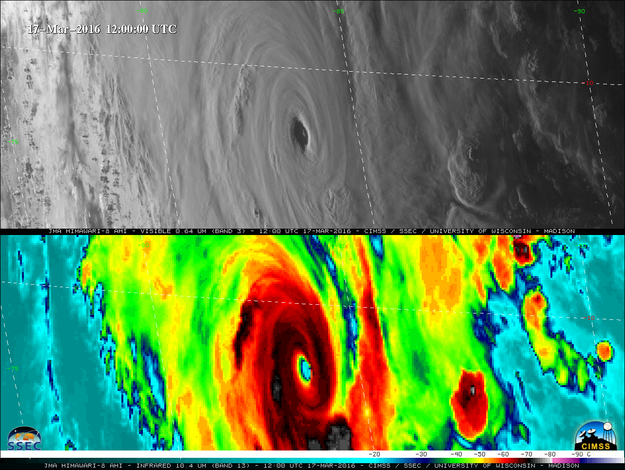
![Himawari-8 Visible (0..64 µm, top) and Infrared Window (10.4 µm, bottom) images [click to play MP4 animation]](https://cimss.ssec.wisc.edu/satellite-blog/wp-content/uploads/sites/5/2016/03/480x1280_H8F_B313_HIM08_VIS_IR_EMERAUDE_17FEB_2016077_120000_0002PANELS.GIF)
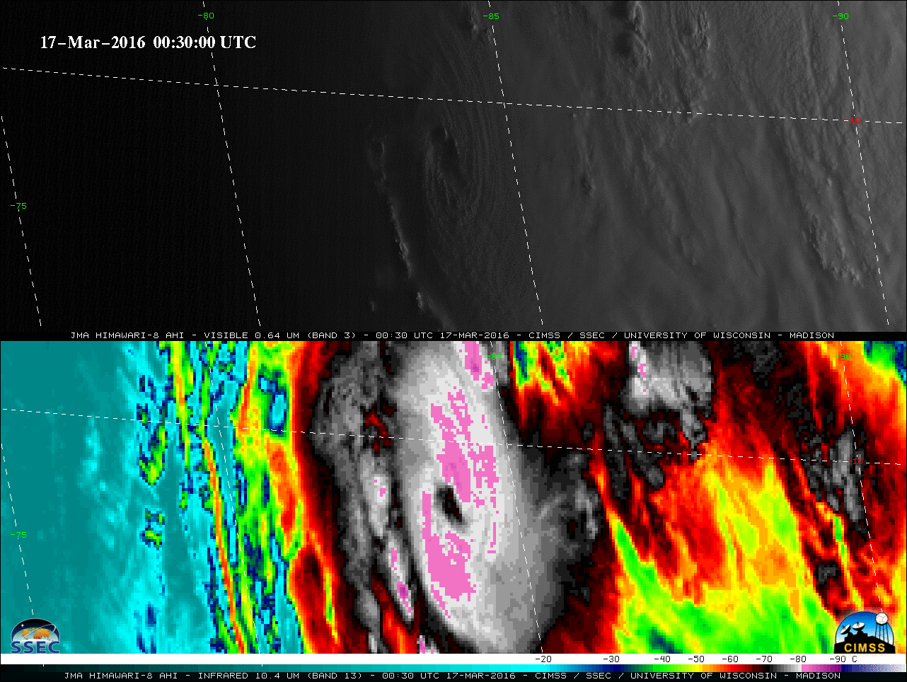
![Suomi NPP VIIRS Day/Night Band (0.7 µm) and Infrared Window (11.45 µm) images [click to enlarge]](https://cimss.ssec.wisc.edu/satellite-blog/wp-content/uploads/sites/5/2016/03/160317_1859utc_suomi_npp_viirs_day_night_band_infrared_Cyclone_Emeraude_anim.gif)
