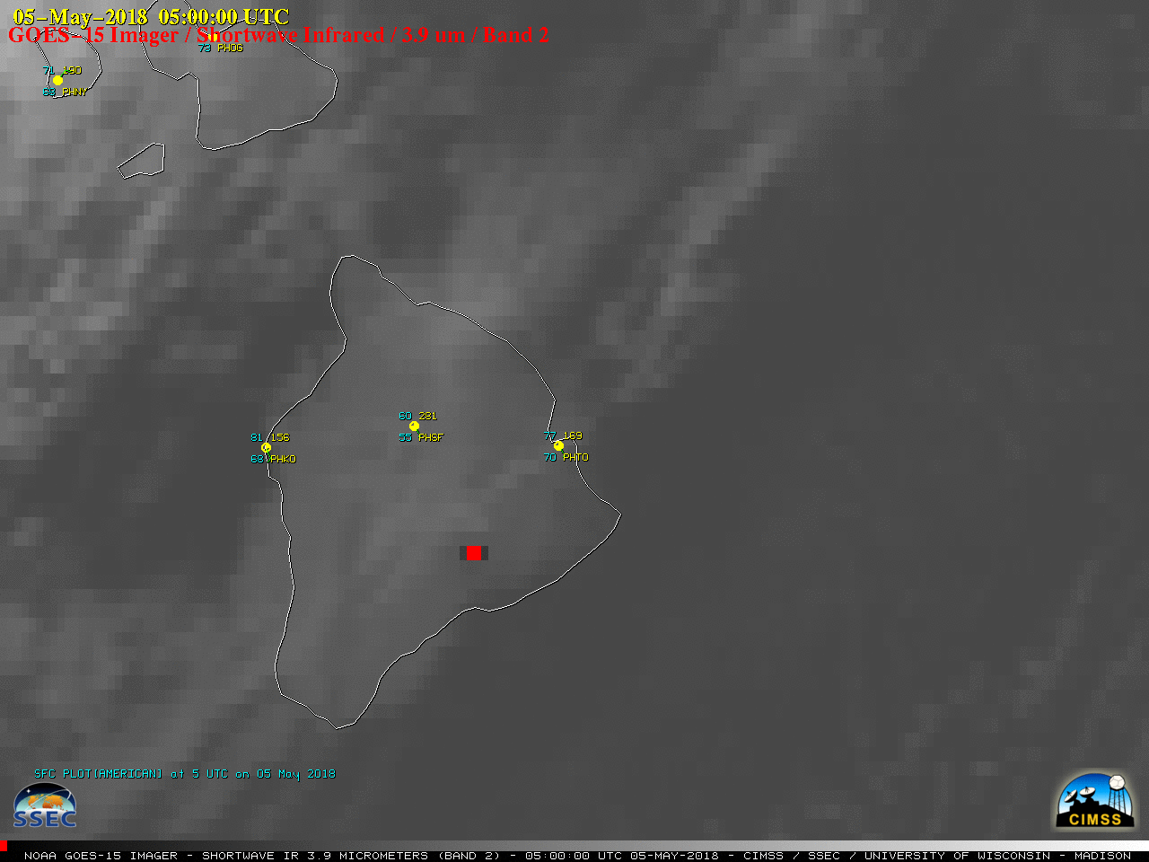
Heightened seismic activity of the Kilauea volcano on the Big Island of Hawai’i had been ongoing since April 2018, but increased further in early May leading to a series of minor eruptions (Hawaiian Volcano Observatory | USGS) — and GOES-15 (GOES-West) Shortwave Infrared (3.9 µm) images (above) showed the nearly persistent thermal... Read More
![GOES-15 Shortwave Infrared (3.9 µm) images, with hourly plots of surface reports [click to play MP4 animation]](https://cimss.ssec.wisc.edu/satellite-blog/wp-content/uploads/sites/5/2018/05/G15_SWIR_HI_KILAUEA_02_052018_960x1280_B2_2018125_050000_0001PANEL_00193.GIF)
GOES-15 Shortwave Infrared (3.9 µm) images, with hourly plots of surface reports [click to play MP4 animation]
Heightened seismic activity of the Kilauea volcano on the Big Island of Hawai’i had been ongoing since April 2018, but increased further in early May leading to a series of minor eruptions (
Hawaiian Volcano Observatory |
USGS) — and GOES-15
(GOES-West) Shortwave Infrared (3.9 µm) images
(above) showed the nearly persistent thermal anomaly or “hot spot”
(dark black to red enhancement) during the 03-05 May period. Among the numerous earthquakes, the strongest was an M6.9 which occurred at 2233 UTC on 04 May.
A nighttime image of Suomi NPP VIIRS Day/Night Band (0.7 µm) data viewed using RealEarth (below) revealed the bright glow from Kilauea, and also from the Leilani Estates subdivision where several fissure vents had opened (forcing some evacuations).
![Suomi NPP VIIRS Day.Night Band (0.7 µm) images, with island boundary and Google Maps labels [click to enlarge]](https://cimss.ssec.wisc.edu/satellite-blog/wp-content/uploads/sites/5/2018/05/180504_1422utc_viirs_DayNightBand_Hawaii_anim.gif)
Suomi NPP VIIRS Day/Night Band (0.7 µm) images, with the island boundary and Google Maps labels [click to enlarge]
A comparison of Suomi NPP VIIRS Day/Night Band images from 03 May and 04 May
(below) showed the before/after difference in the bright signal emitted by the fissure vents near Leilani Estates.
![Suomi NPP VIIRS Day/Night Band (0.7 µm) images from 03 May and 04 May [click to enlarge]](https://cimss.ssec.wisc.edu/satellite-blog/wp-content/uploads/sites/5/2018/05/180503_04_suomi_npp_viirs_DayNightBand_Leilani_Estates_HI_anim.gif)
Suomi NPP VIIRS Day/Night Band (0.7 µm) images from 03 May and 04 May [click to enlarge]
===== 06 May Update =====
Eruptions of fissure vents became more continuous in the Leilani Estates subdivision on 06 May. A comparison of GOES-15 Visible and Shortwave Infrared images (below) showed a long volcanic plume streaming southwestward, with robust thermal anomaly activity at the plume source.
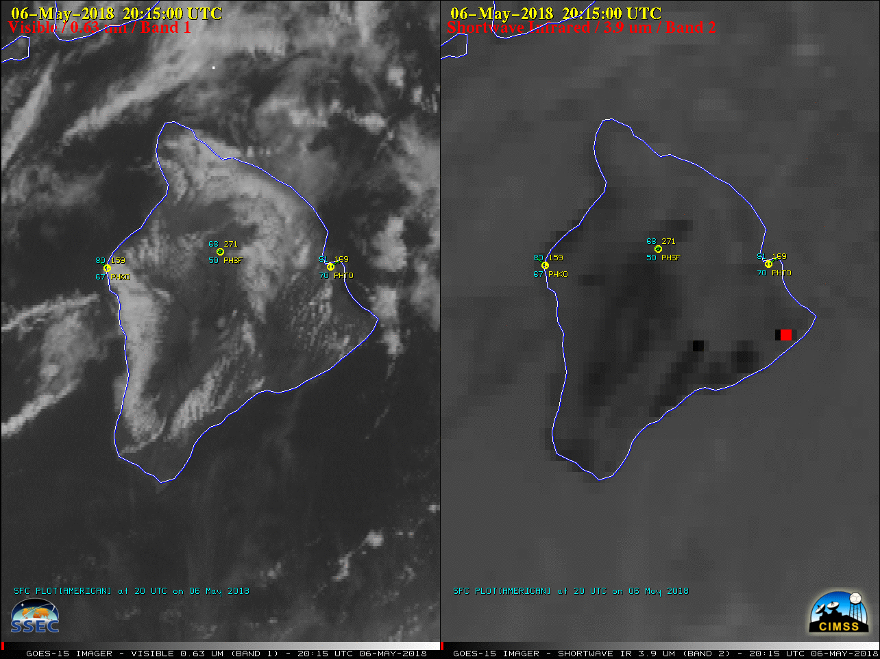
GOES-15 Visible (0.63 µm, left) and Shortwave Infrared (3.9 µm, right) images, with hourly plots of surface reports [click to play animation | MP4]
An Aqua MODIS True-color Red-Green-Blue (RGB) image
(below) provided a more detailed view of the volcanic plume at 0007 UTC on 07 May. Note the cluster of red thermal anomalies in the vicinity of the Leilani Estates subdivision (the source of the plume).
![Aqua MODIS True-color RGB image [click to enlarge]](https://cimss.ssec.wisc.edu/satellite-blog/wp-content/uploads/sites/5/2018/05/180507_0007utc_aqua_modis_truecolor_HI.jpeg)
Aqua MODIS True-color RGB image, with VIIRS thermal anomalies plotted in red [click to enlarge]
View only this post
Read Less


![Terra MODIS True-color image [click to enlarge]](https://cimss.ssec.wisc.edu/satellite-blog/wp-content/uploads/sites/5/2018/04/180501_1539utc_terra_modis_truecolor.jpeg)

![Time series of surface observation data at Grafton, North Dakota [click to enlarge]](https://cimss.ssec.wisc.edu/satellite-blog/wp-content/uploads/sites/5/2018/04/180429_KGAF_SFCMG.GIF)
![Time series plot of surface weather data at Winnipeg, Manitoba [click to enlarge]](https://cimss.ssec.wisc.edu/satellite-blog/wp-content/uploads/sites/5/2018/04/180429_CYWG_SFCMG.GIF)
