This website works best with a newer web browser such as Chrome, Firefox, Safari or Microsoft Edge. Internet Explorer is not supported by this website.

Tropical Depression One-E forms in the East Pacific Ocean

1-minute Mesoscale Domain Sector GOES-17 (GOES-West) “Red” Visible (0.64 µm) and “Clean” Infrared Window (10.35 µm) images (above) showed the circulation of Tropical Invest 90E in the East Pacific Ocean on 24 April 2020. The low-level circulation center appeared to be located about 100 miles southwest of the 18 UTC surface analysis position.GOES-17 Visible... Read More

GOES-17 “Red” Visible (0.64 µm) and “Clean” Infrared Window (10.35 µm) images [click to play animation | MP4]

GOES-17 “Red” Visible (0.64 µm) and “Clean” Infrared Window (10.35 µm) images [click to play animation | MP4]

1-minute Mesoscale Domain Sector GOES-17 (GOES-West) “Red” Visible (0.64 µm) and “Clean” Infrared Window (10.35 µm) images (above) showed the circulation of Tropical Invest 90E in the East Pacific Ocean on 24 April 2020. The low-level circulation center appeared to be located about 100 miles southwest of the 18 UTC surface analysis position.

GOES-17 Visible images with a plot of Deep-Layer Wind Shear from the CIMSS Tropical Cyclones site (below) indicated that Invest 90E was embedded within an environment of low shear — the National Hurricane Center gave the feature an 80% chance of further developing into a tropical depression within 48 hours.

GOES-17 “Red” Visible (0.64 µm) with a plot of Deep-Layer Wind Shear at 23 UTC images [click to enlarge]

GOES-17 “Red” Visible (0.64 µm) images, with a plot of Deep-Layer Wind Shear at 23 UTC [click to enlarge]

VIIRS True Color RGB and Infrared Window (11.45 µm) images from NOAA-20 and Suomi NPP as viewed using RealEarth (below) revealed tendrils of transverse banding along the western and northern periphery if the disturbance.

VIIRS True Color RGB and Infrared Window (11.45 µm) images from NOAA-20 and Suomi NPP [click to enlarge]

VIIRS True Color RGB and Infrared Window (11.45 µm) images from NOAA-20 and Suomi NPP [click to enlarge]

===== 25 April Update =====

GOES-17 “Clean” Infrared Window (10.35 µm) images [click to play animation | MP4]

GOES-17 “Clean” Infrared Window (10.35 µm) images [click to play animation | MP4]

GOES-17 Infrared images (above) showed the period when the disturbance became classified as Tropical Depression One-E at 15 UTC — making this the earliest tropical cyclone on record in the East Pacific basin during the satellite era.

GOES-17 “Clean” Infrared Window (10.35 µm) images [click to play animation | MP4]

GOES-17 “Clean” Infrared Window (10.35 µm) images [click to play animation | MP4]

GOES-17 Infrared images with plots of tropical surface analyses (above) indicated that TD One-E was situated just north of the Intertropical Convergence Zone (ITCZ). The MIMIC-TPW product (below) showed that the tropical depression was tapping moisture from the ITCZ and drawing it northward.

MIMIC Total Precipitable Water product [click to enlarge]

MIMIC Total Precipitable Water product [click to enlarge]

GOES-17 Visible images (below) revealed an exposed low-level circulation that was displaced north-northwest of the primary cluster of deep convection.

GOES-17 “Red” Visible (0.64 µm) images [click to play animation | MP4]

GOES-17 “Red” Visible (0.64 µm) images [click to play animation | MP4]

View only this post Read Less

GOES-17 Scanning designed to reduce heating-caused data outages

NOAA/NESDIS has modified the GOES-17 Mode 6 scanning schedule during times of increased data-outages related to the faulty Loop Heat Pipe (LHP) mechanism (Blog Post 1, 2, 3 on that subject;  see also here) on GOES-17.  (The OSPO Notification is here).  Between 0600 and 1200 UTC, Full Disk scans are... Read More

GOES-17 Upper Level Water Vapor (Band 8, 6.19 µm) Infrared Imagery, 0400-1620 (Click to animate)

NOAA/NESDIS has modified the GOES-17 Mode 6 scanning schedule during times of increased data-outages related to the faulty Loop Heat Pipe (LHP) mechanism (Blog Post 1, 2, 3 on that subject;  see also here) on GOES-17.  (The OSPO Notification is here).  Between 0600 and 1200 UTC, Full Disk scans are imaged every 15 minutes, rather than every 10;  the two flexible mesoscale sectors (including the one with a default location over Alaska) are scanned every 2 minutes, rather than every minute;  the GOES-17 ‘CONUS’ domain, also known as the PACUS domain, typically scanned every 5 minutes, is not scanned at all.  These modifications will be in place in 2020 from 9 April through 1 May, from 12 August through 1 September and from 14 October through 31 October.  Dates for 2021 (and beyond) have not yet been determined.  The ‘time-time’ chart for this modified scanning is shown below (figure source).

‘Time-Time’ chart for GOES-17 Scanning during Mode 3 Cooling operations. Cyan regions denote no ABI scanning activity, green regions are Meoscale sector scans, pink denotes the full disk scan. Other colors show navigation and calibration times. Note the lack of a 5-minute PACUS scan (Click to enlarge)

This change in scanning strategy mitigates heating-caused imagery losses because it reduces the amount thermal energy absorbed by the ABI when it is pointed towards a warm source (that is, Earth) instead of cold outer space.  By reducing the scanning periods, OSPO reduced (but did not eliminate) the span of time during which time data from many of the infrared channels of the ABI are unusable because of saturated sensors.

Note in the animation above how the time-step changes at 0600 UTC to every 15 minutes, and then changes back to every 10 minutes at 1200 UTC.  A slower animation from 0530 – 0630 UTC (link) shows that increment change more clearly.  Because the so-called CONUS scan does not happen, GOES-17 CONUS scan imagery is not available during this time window;  of course, data are available in the CONUS region via the every-15-minute Full Disk scans.

The image below, courtesy Mat Gunshor, CIMSS, (derived from this website) shows how this Mode 3 Cooling Operations reduces the window when data are unavailable.  The time span when data are unusable (highlighted by the green double-headed arrows) is shorter in 2020 as a result of this new scanning strategy.  Also, the peak Focal Plane Module (FPM) Temperature is reduced, which may have implications for the long-term health of the satellite.

Comparisons between GOES-16 and GOES-17 Low-Level water vapor infrared imagery (Band 10, 7.34 µm).  Julian day 104 from 2019 (left) and 2020 (right).  GOES-16 and -17 Full-Disk imagery at the end of the time series as shown.  Time series plots (bottom) show the Focal Plane Module (FPM) temperature (black) and the GOES-17 – GOES-16 brightness temperature difference (blue) for a region centered on the Equator equidistant between the two satellite sub-points.

View only this post Read Less

Severe weather in Oklahoma, Texas and Louisiana

1-minute Mesoscale Domain Sector GOES-16 (GOES-East) “Red” Visible (0.64 µm) and “Clean” Infrared Window (10.35 µm) images (above) showed thunderstorms that produced a variety of severe weather (SPC Storm Reports) across far southern Oklahoma on 22 April 2020. These discrete supercell storms developed along a cold front associated with a low pressure system moving across the region (surface analyses).GOES-16... Read More

GOES-16

GOES-16 “Red” Visible (0.64 µm) and “Clean” Infrared Window (10.35 µm) images [click to play animation | MP4]

1-minute Mesoscale Domain Sector GOES-16 (GOES-East) “Red” Visible (0.64 µm) and “Clean” Infrared Window (10.35 µm) images (above) showed thunderstorms that produced a variety of severe weather (SPC Storm Reports) across far southern Oklahoma on 22 April 2020. These discrete supercell storms developed along a cold front associated with a low pressure system moving across the region (surface analyses).

GOES-16 Visible and Infrared images with plots of time-matched SPC Storm Reports are shown below.

GOES-16 "Red" Visible (0.64 µm, top) and "Clean" Infrared Window (10.35 µm, bottom) images, with plots of SPC Storm Reports [click to play animation | MP4]

GOES-16 “Red” Visible (0.64 µm, top) and “Clean” Infrared Window (10.35 µm, bottom) images, with plots of SPC Storm Reports [click to play animation | MP4]

Farther to the southeast across eastern Texas, GOES-16 Visible and Infrared images (below) revealed a large and long-lived supercell thunderstorm that eventually moved eastward into Louisiana.

GOES-16 "Red" Visible (0.64 µm) and "Clean" Infrared Window (10.35 µm) images [click to play animation | MP4]

GOES-16 “Red” Visible (0.64 µm) and “Clean” Infrared Window (10.35 µm) images [click to play animation | MP4]

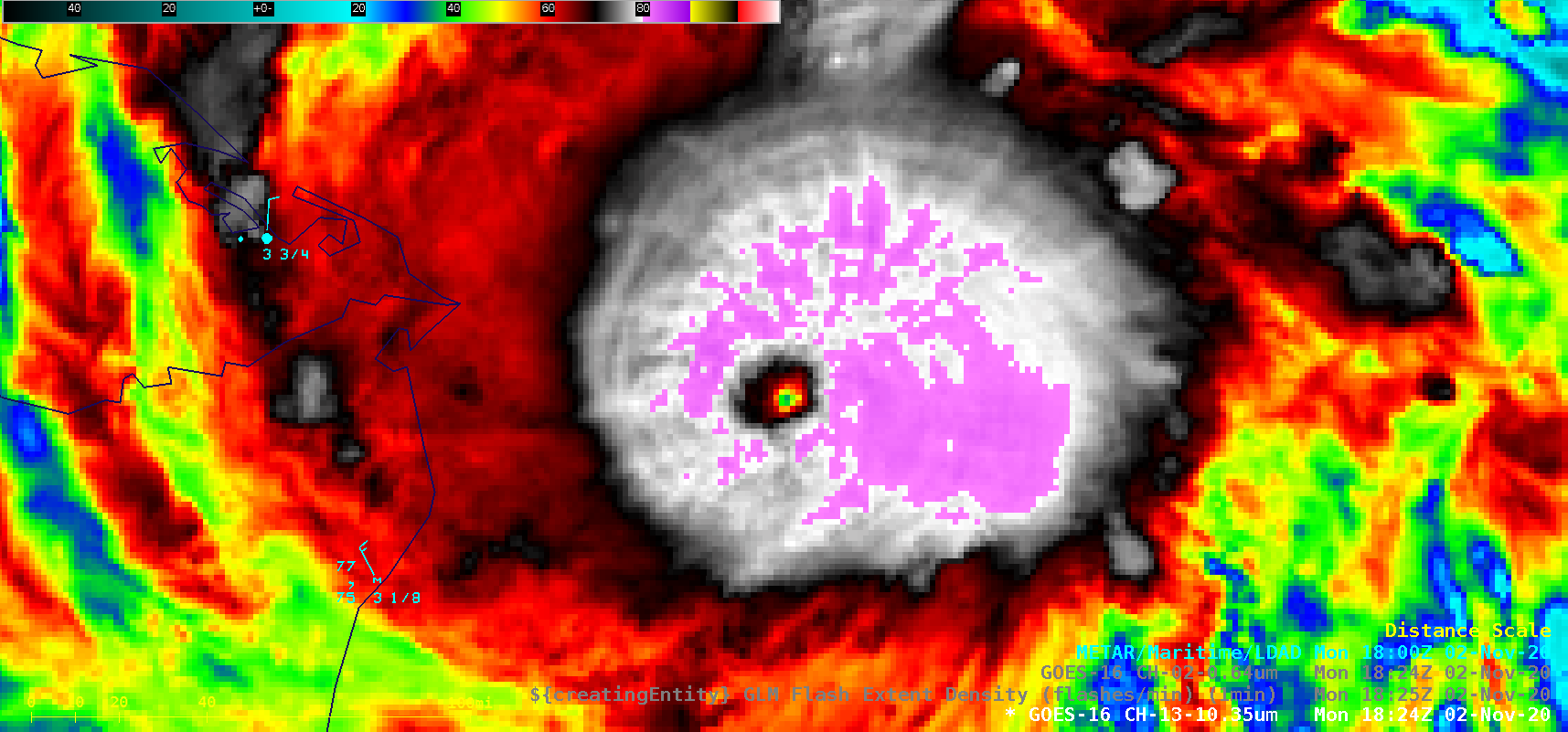
GOES-16 Visible and Infrared images with plots of time-matched SPC Storm Reports are shown below. An Above-Anvil Cirrus Plume was produced by this thunderstorm, and cloud-top infrared brightness temperatures were as cold as -80ºC (violet pixels). Early in its life cycle, after dropping hail of 1.0-2.0 inches in diameter, the supercell produced the fatal EF-3 Onalaska tornado.

GOES-16 "Red" Visible (0.64 µm, top) and "Clean" Infrared Window (10.35 µm, bottom) images, with plots of SPC Storm Reports [click to play animation | MP4]

GOES-16 “Red” Visible (0.64 µm, top) and “Clean” Infrared Window (10.35 µm, bottom) images, with plots of SPC Storm Reports [click to play animation | MP4]

A toggle between 1-km resolution NOAA-19 AVHRR Visible (0.63 µm) and Infrared Window (10.8 µm) images at 2338 UTC (below) provided a more detailed view of the Above-Anvil Cirrus Plume. The coldest cloud-top infrared brightness temperature in the region of the overshooting top was -84.7ºC.

NOAA-19 AVHRR Visible (0.63 µm) and Infrared Window (10.8 µm) images [click to enlarge]

NOAA-19 AVHRR Visible (0.63 µm) and Infrared Window (10.8 µm) images [click to enlarge]

Additional imagery of these storms is available on the Satellite Liaison Blog.

View only this post Read Less

Gridded NUCAPS fields around nocturnal convection over the southern Plains

GOES-16 Clean Window (10.3 µm) infrared imagery, above (click to animate) shows two regions of convection over the southern Plains, one moving through central/southern Oklahoma, one developing over the Texas Panhandle and moving east). A similar (but slightly later) animation of GOES-16 Low-Level water vapor infrared imagery (7.34 µm) is... Read More

GOES-16 Clean Window (10.3 µm) infrared imagery, 0346 – 1021 UTC, 22 April 2020 (click to animate)

GOES-16 Clean Window (10.3 µm) infrared imagery, above (click to animate) shows two regions of convection over the southern Plains, one moving through central/southern Oklahoma, one developing over the Texas Panhandle and moving east). A similar (but slightly later) animation of GOES-16 Low-Level water vapor infrared imagery (7.34 µm) is below.

GOES-16 Low-Level water vapor (7.3 µm) infrared imagery, 0456 – 1441 UTC, 22 April 2020 (click to animate)

At 0821 UTC, two distinct mesoscale convective complexes are apparent, with a clear region between. This time approximated an overpass by NOAA-20; data from the Cross-track Infrared Sounder (CrIS) and the Advanced Technology Microwave Sounder (ATMS) are combined to create NUCAPS soundings.

GOES-16 Low-Level water vapor (7.3 µm) infrared imagery, 0826 UTC, 22 April 2020, along with NUCAPS sounding points (click to enlarge)

During this time, there were three soundings launched at Amarillo — at 0000, 0600 and 1200 UTC.  They are shown below and all three suggest steep mid-level lapse rates.

Radiosonde from Amarillo TX at 0000, 0600 and 1200 UTC on 22 April 2020 (Click to enlarge)

The NUCAPS profile south of Amarillo (in the water vapor image above, the ‘green’ point just south of the ‘red’ point just south of the convective system over Amarillo) is shown below.  It also shows fairly steep mid-level lapse rates.  Click here to see a toggle between the NUCAPS profile below and the 0600 UTC Amarillo Radiosonde.

NUCAPS Profile at 35 N, 101 W, 0821 UTC on 22 April 2020 (Click to enlarge)

Gridded NUCAPS fields allow a forecaster to view thermodynamic information from the entire pass more easily than can be achieved by examination of individual soundings, or by viewing soundings via the pop-up SkewT.  The animation below shows the Total Totals index, the 850-500-mb lapse rate, and the lapse rate from 700-300 mb.  Strong instability (Total Totals values around 50) is indicated downstream of the system over the Texas panhandle; also, lapse rates are steeper between 700 and 300 mb (about 7.5º C/km) compared to those between 850 and 500 mb (about 6.8º C/km).

Gridded NUCAPS data gives timely satellite-derived (and model-independent) estimates of the thermodynamic state of the atmosphere.

Gridded NOAA-20 NUCAPS estimates of Total Totals index, 850-500 mb Lapse Rate and 700-300 mb Lapse Rate (Click to enlarge)

View only this post Read Less