This website works best with a newer web browser such as Chrome, Firefox, Safari or Microsoft Edge. Internet Explorer is not supported by this website.

The transition to Winter across southern Wisconsin

A sequence of MODIS true color images (from the SSEC MODIS Direct Broadcast site) covering the period from 27 November 2007 to 02 January 2008 (above) shows the transition from predominantly bare ground (with only isolated patches of thin snow cover) at the end of November to widespread deep snow cover across all... Read More

MODIS true color images (Animated GIF)

A sequence of MODIS true color images (from the SSEC MODIS Direct Broadcast site) covering the period from 27 November 2007 to 02 January 2008 (above) shows the transition from predominantly bare ground (with only isolated patches of thin snow cover) at the end of November to widespread deep snow cover across all of southern Wisconsin during the month of December 2007. Madison, Wisconsin (located at the center of the images) experienced its second snowiest December on record, with 33.5 inches falling during the month. The maximum snow depth at the Madison airport was 12 inches (on both 12 and 16 December), but NWS Cooperative Observers in the Madison metro area reported snow depths as high as 16 inches; across southern Wisconsin, a maximum snow depth of 22 inches was reported at Germantown and Jackson.

While the official temperature at the Madison airport did get as low as -10ºF on 06 December, the month as a whole was only 1.8ºF below normal (average temperature: 21.2ºF); as a result, the lakes in the Madison area froze within about a week of their median freeze dates. The images above show that several of the more shallow lakes southeast of Madison were the first to freeze, with the largest of the Madison lakes (Lake Mendota) appearing totally frozen and white with deep snow cover on the final 02 January 2008 true color image. Contrast this to the previous winter season, when Lake Mendota did not freeze until 20 January 2007 (the second latest freeze date on record!).

View only this post Read Less
Meso-vortex and lake-effect snow band over Lake Michigan

An animation of GOES-12 3.9 µm shortwave IR (nighttime) and visible channel (daytime) images (above) shows a well-defined meso-vortex and single lake-effect snow (LES) band moving southward across the southern portion of Lake Michigan on 02 January 2008. This narrow (but intense) LES band and meso-vortex contributed to impressive storm total snowfall... Read More

GOES-12 3.9µm IR + visible images (Animated GIF)

An animation of GOES-12 3.9 µm shortwave IR (nighttime) and visible channel (daytime) images (above) shows a well-defined meso-vortex and single lake-effect snow (LES) band moving southward across the southern portion of Lake Michigan on 02 January 2008. This narrow (but intense) LES band and meso-vortex contributed to impressive storm total snowfall amounts that included 26.0 inches at Hudson Lake, Indiana (located about 15 miles west of South Bend, Indiana — station identifier KSBN) and 18.5 inches at Buchanan, Michigan (located about 10 miles northwest of KSBN) — however, it appears that the majority of those storm total snowfall amounts were due to synoptic-scale snow and lake-enhanced snow processes during the preceding 24-48 hours.

Mid-lake convergence played a role in the formation and maintenance of the LES band, as seen in an AWIPS image of the MODIS visible channel with CIMSS GOES Mesoscale Winds overlaid (below).

AWIPS MODIS visible + mesoscale winds

An AWIPS 4-panel display of MODIS images (below) shows the visible channel (upper left panel), 2.1 µm near-IR “Snow/Ice” channel (upper right panel), Cloud Top Temperature product (lower left panel), and Cloud Phase product (lower right panel) at 16:45 UTC (10:45 am local time). The darker appearance of the thickest (eastern) portion of the LES band on the MODIS “snow/ice” image suggested that part of the cloud band had glaciated and was composted primarily of ice crystals at that time (snow and ice are strong absorbers at the 2.1 µm wavelength, and appear much darker than supercooled water droplet clouds on the MODIS Snow/Ice channel imagery); this idea was further supported by corresponding MODIS Cloud Top Temperatures in the -15ºC to -20ºC range (cyan to dark blue enhancement, lower left panel) and “mixed phase” pixels on the MODIS Cloud Phase product (dark gray enhancement, lower right panel).

AWIPS MODIS 4-panel image

View only this post Read Less
Another subtropical storm in the Atlantic?

If you thought that Tropical Storm Olga was the last gasp of the 2007 North Atlantic basin’s Tropical Cyclone season, think again: GOES-12 10.7 µm IR channel imagery (above; closer view) and 6.5 µm water vapor channel imagery (below) revealed a circulation southwest of the Azores on 29 December 2007 (centered near 28º... Read More

GOES-12 10.7µm IR images (Animated GIF)

If you thought that Tropical Storm Olga was the last gasp of the 2007 North Atlantic basin’s Tropical Cyclone season, think again: GOES-12 10.7 µm IR channel imagery (above; closer view) and 6.5 µm water vapor channel imagery (below) revealed a circulation southwest of the Azores on 29 December 2007 (centered near 28º North latitude, 47º West longitude) that appeared to be acquiring subtropical characteristics as it began to produce gale-force winds and some convection (evident in this 500-m resolution MODIS visible image) within the northeastern quadrant of the disturbance.

GOES-12 6.5 µm water vapor imagery (Animated GIF)

===============================================

Meteosat-8 visible image

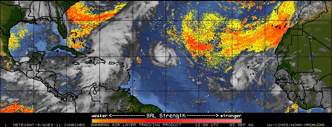
A Meteosat-8 visible channel image (above) showed the circulation well off the coast of Africa at 12:00 UTC on 29 December. In addition, note the “hazy” appearance of the cloud-free region over and just south of the Cap-Vert region of northwestern Africa (not the larger sun glint feature seen farther south over the subtropical South Atlantic — the Saharan Air Layer (SAL) tracking product (below) suggests that this could be an area of airborne dust (yellow to orange enhancement) moving westward from the Sahara desert across the far eastern Atlantic Ocean (a good deal of the yellow-to-orange signal across the rest of the North Atlantic is a “false positive” SAL/dust signal).

Saharan Air Layer (SAL) tracking product

View only this post Read Less
Google Earth Imagery from SSEC

Two new sources of Google Earth satellite imagery are now available from SSEC: AVHRR images from the NOAA operational polar orbiting satellites, and MODIS images from the NASA Terra and Aqua satellites. An example of the AVHRR “false color” imagery (above) zooms in to show the deep snow cover that existed over much of the Upper Midwest... Read More

AVHRR imagery in Google Earth (Animated GIF)

Two new sources of Google Earth satellite imagery are now available from SSEC: AVHRR images from the NOAA operational polar orbiting satellites, and MODIS images from the NASA Terra and Aqua satellites. An example of the AVHRR “false color” imagery (above) zooms in to show the deep snow cover that existed over much of the Upper Midwest on 17 December 2007. Note the darker appearance of the Chicago IL and Milwaukee WI metro areas; even though those cities had a significant amount of snow on the ground, the higher concentration of trees, buildings, and paved surfaces all contributed to a somewhat “darker” satellite scene in those urban areas (compared to the adjacent outlying rural areas). Also evident on the AVHRR image were well-defined lake-effect snow bands over Lake Michigan that were moving inland over portions of Michigan and Indiana — these snow bands were on the far western periphery of a large winter storm that was centered over the Northeast US.

MODIS Google Earth imagery

MODIS “true color” imagery from the MODIS Today site (above) revealed a large number of lake-effect snow (LES) bands over parts of Lake Superior, Lake Michigan, and Lake Huron as cold arctic air streamed southward across the Great Lakes on 14 December 2007; these LES bands produced 3-6 inches of snowfall at some locations in the Upper Peninsula of Michigan. On that same day, MODIS imagery farther to the east showed a variety of banded cloud features over the Mid-Atlantic states (below).

MODIS Google Earth imagery

View only this post Read Less