Hat-tip to blog reader Boris Konon for sending us this in an email:Noted a large area of extremely cold cloud tops on a thunderstorm complex over northern Australia 17-23z 11/22. So cold it went off our IR color table scale we use here at WSI for MTSAT!MTSAT-1R Infrared (10.8... Read More
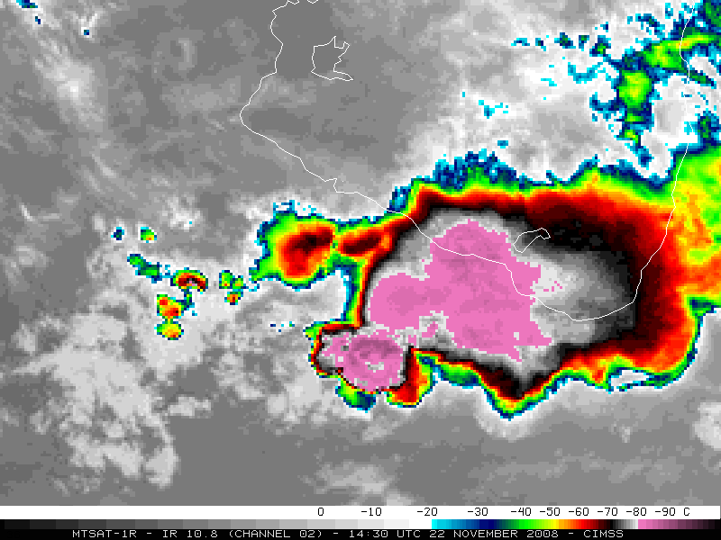
MTSAT-1R Infrared (10.8 µm) images [click to enlarge]
Hat-tip to blog reader Boris Konon for sending us this in an email:
Noted a large area of extremely cold cloud tops on a thunderstorm complex over northern Australia 17-23z 11/22. So cold it went off our IR color table scale we use here at WSI for MTSAT!
MTSAT-1R Infrared (10.8 µm) images (above) did indeed show an area of convection that exhibited an unusually large canopy of cloud top temperatures colder than -80ºC (shades of violet to purple) on 22 November 2008. The coldest infrared brightness temperature seen with this particular thunderstorm complex was 174.78 K (-98.37ºC), just off the northern coast of Australia at 2030 UTC.
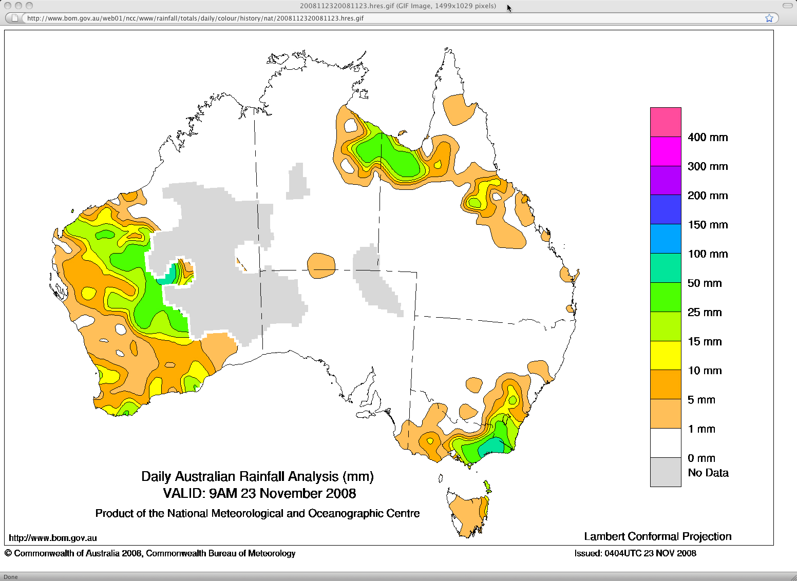
A comparison of MTSAT-1R Visible and Infrared images at 2030 UTC (below) showed that there were a number of overshooting tops within the area of cold cloud-top temperatures, as the convective system was beginning to move offshore across the Gulf of Carpenteria. This squall line was responsible for producing 25-50 mm of rainfall (BOM rainfall analysis) and wind gusts to 96 km/h (52 knots) at Bradshaw and 68 km/h (37 knots) at Gove (thanks to Jeff Callaghan, Australian Bureau of Meteorology for that information!).
![MTSAT-1R Visible and Infrared images [click to enlarge]](https://cimss.ssec.wisc.edu/satellite-blog/wp-content/uploads/sites/5/2008/11/081122_mtsat_vis_ir_anim.gif)
MTSAT-1R Visible and Infrared images [click to enlarge]
A closer view using 1-km resolution NOAA-15 AVHRR Infrared (10.8 µm) imagery
(below) revealed a bit more detail in the cloud-top temperature structure around 1956 UTC. Unfortunately, the image was marred by a large number of “noise” pixels — but the coldest reliable cloud-top infrared brightness temperature seen on this AVHRR image was
170.2 K (-102.95ºC), located within the farthest southeast cold pixel cluster
(IR brightness temperatures of -100ºC and colder are enhanced in the yellow to brown colors at the end of the scale). If this cloud-top brightness temperature is accurate, it rivals what is believed to be the coldest satellite-sensed cloud top temperature value noted in the literature:
-102.2ºC in Ebert and Holland, 1992.
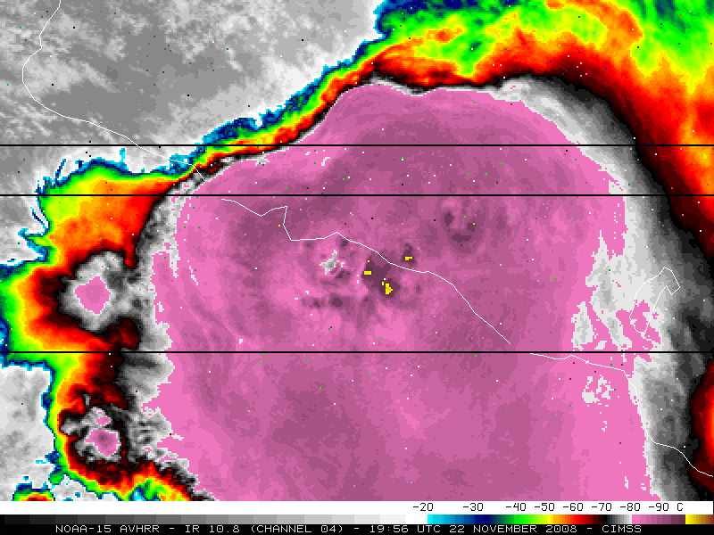
NOAA-15 AVHRR Infrared (10.8 µm) image [click to enlarge]
Rawinsonde data from Darwin Airport at 0000 UTC on 23 November 2008
(below) indicates that the tropopause was at a very high altitude
(around 100 hPa, approximately 16.0 km). Such a high and cold tropopause is not unusal in the tropics — especially in that particular region, as studies have shown that the average tropopause level is quite high and quite cold over the western tropical Pacific Ocean.
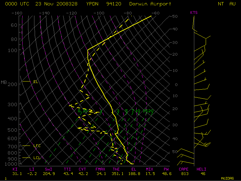
Darwin, Australia rawinsonde report [click to enlarge]
View only this post
Read Less


