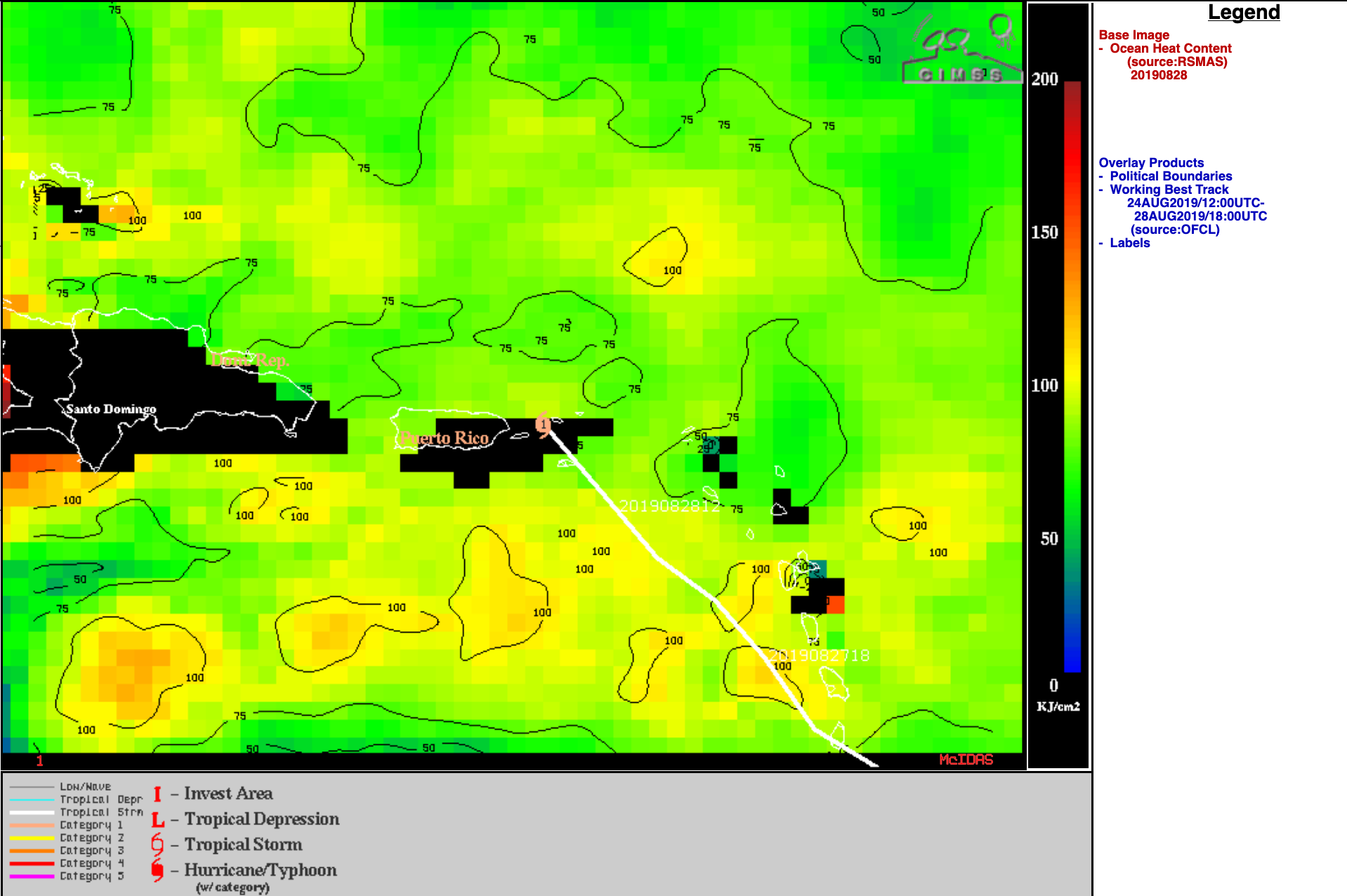
Hurricane Dorian
![NOAA-20 Day/Night Band (0.7 µm) and Infrared Window (11.45 µm) images, courtesy of William Straka (CIMSS) [click to enlarge]](https://cimss.ssec.wisc.edu/satellite-blog/wp-content/uploads/sites/5/2019/08/190828_0606utc_noaa20_dayNightBand_infraredWindow_TS_Dorian_anim.gif)
NOAA-20 VIIRS Day/Night Band (0.7 µm) and Infrared Window (11.45 µm) images, courtesy of William Straka (CIMSS) [click to enlarge]
In a toggle between GOES-16 (GOES-East) “Clean” Infrared Window (10.35 µm) and DMSP-18 SSMIS Microwave (85 GHz) images from the CIMSS Tropical Cyclones site (below), the Microwave image revealed a convective band that was wrapping around the northern portion of the center of Dorian at 0930 UTC.
![GOES-16 "Clean" Infrared Window <em>(10.35 µm)</em> and DMSP-18 SSMIS Microwave <em>(85 GHz)</em> images [click to enlarge]](https://cimss.ssec.wisc.edu/satellite-blog/wp-content/uploads/sites/5/2019/08/190828_0930utc_goes16_infrared_dmsp18_microwave_Dorian_anim.gif)
GOES-16 “Clean” Infrared Window (10.35 µm) and DMSP-18 SSMIS Microwave (85 GHz) images [click to enlarge]
![GOES-16 “Red” Visible (0.64 µm) and “Clean” Infrared Window (10.35 µm) images [click to play animation | MP4]](https://cimss.ssec.wisc.edu/satellite-blog/wp-content/uploads/sites/5/2019/08/190828_goes16_visible_infrared_TS_Dorian_anim.gif)
GOES-16 “Red” Visible (0.64 µm) and “Clean” Infrared Window (10.35 µm) images [click to play animation | MP4]
![https://cimss.ssec.wisc.edu/satellite-blog/wp-content/uploads/sites/5/2019/08/.gifGOES-16 Infrared Window (10.35 µm) images, with contours of deep-layer wind shear at 19 UTC [click to enlarge]](https://cimss.ssec.wisc.edu/satellite-blog/wp-content/uploads/sites/5/2019/08/190828_goes16_infrared_19utc_deepLayerWindShear_Dorian_anim.gif)
GOES-16 Infrared Window (10.35 µm) images, with contours of deep-layer wind shear at 19 UTC [click to enlarge]
![VIIRS True Color RGB and Infrared Window (11.45 µm) images [click to enlarge]](https://cimss.ssec.wisc.edu/satellite-blog/wp-content/uploads/sites/5/2019/08/190828_1717utc_noaa20_1807utc_suomiNPP_viirs_trueColor_infraredWindow_Dorian_anim.gif)
VIIRS True Color RGB and Infrared Window (11.45 µm) images from NOAA-20 and Suomi NPP [click to enlarge]
![GOES-16 Infrared (10.35 µm) and GMI Microwave (85 GHz) images [click to enlarge]](https://cimss.ssec.wisc.edu/satellite-blog/wp-content/uploads/sites/5/2019/08/190828_2130utc_goe16_infrared_2141utc_gmi_microwave_Dorian_anim.gif)
GOES-16 Infrared (10.35 µm) and GMI Microwave (85 GHz) images [click to enlarge]
===== 29 August Update =====
![GOES-16 “Red” Visible (0.64 µm) and “Clean” Infrared Window (10.35 µm) images [click to play animation | MP4]](https://cimss.ssec.wisc.edu/satellite-blog/wp-content/uploads/sites/5/2019/08/190829_goes16_visible_infrared_Hurricane_Dorian_anim.gif)
GOES-16 “Red” Visible (0.64 µm) and “Clean” Infrared Window (10.35 µm) images [click to play animation | MP4]
During one of those convective bursts from 1800-1900 UTC, an increase in GOES-16 GLM Flash Extent Density was evident (below).
![GOES-16 “Red” Visible (0.64 µm) and “Clean” Infrared Window (10.35 µm) images, with and without overlays of GLM Flash Extent Density [click to play animation | MP4]](https://cimss.ssec.wisc.edu/satellite-blog/wp-content/uploads/sites/5/2019/08/190829_1800_1900utc_goes16_visible_infrared_glmFlashExtentDensity_Hurricane_Dorian_anim.gif)
GOES-16 “Red” Visible (0.64 µm) and “Clean” Infrared Window (10.35 µm) images, with and without overlays of GLM Flash Extent Density [click to play animation | MP4]
![GOES-16 “Red” Visible (0.64 µm) image at 1853 UTC, with and without an overlay of GLM Flash Extent Density [click to enlarge]](https://cimss.ssec.wisc.edu/satellite-blog/wp-content/uploads/sites/5/2019/08/190829_1852utc_goes16_visible_glmFED_Dorian_anim.gif)
GOES-16 “Red” Visible (0.64 µm) image at 1852 UTC, with and without an overlay of GLM Flash Extent Density [click to enlarge]
![GOES-16 “Clean” Infrared Window (10.35 µm) image at 1853 UTC, with and without an overlay of GLM Flash Extent Density [click to enlarge]](https://cimss.ssec.wisc.edu/satellite-blog/wp-content/uploads/sites/5/2019/08/190829_1852utc_goes16_infrared_glmFED_Dorian_anim.gif)
GOES-16 “Clean” Infrared Window (10.35 µm) image at 1852 UTC, with and without an overlay of GLM Flash Extent Density [click to enlarge]
===== 30 August Update =====
![GOES-16 “Red” Visible (0.64 µm) and “Clean” Infrared Window (10.35 µm) images [click to play animation | MP4]](https://cimss.ssec.wisc.edu/satellite-blog/wp-content/uploads/sites/5/2019/08/190830_goes16_visible_infrared_Dorian_anim.gif)
GOES-16 “Red” Visible (0.64 µm) and “Clean” Infrared Window (10.35 µm) images [click to play animation | MP4]
A DMSP-17 Microwave (85 GHz) Microwave image at 1141 UTC (below) did not yet show a completely closed eyewall structure at that earlier time.
![DMSP-17 SSMIS Microwave (85 GHz) Microwave image [click to enlarge]](https://cimss.ssec.wisc.edu/satellite-blog/wp-content/uploads/sites/5/2019/08/190830_1415utc_dmsp17_ssmis_mw_Dorian.png)
DMSP-17 SSMIS Microwave (85 GHz) Microwave image [click to enlarge]
![GOES-16 “Red” Visible (0.64 µm) images, with and without overlays of GLM Flash Extent Density [click to play animation | MP4]](https://cimss.ssec.wisc.edu/satellite-blog/wp-content/uploads/sites/5/2019/08/190830_15-18utc_goes16_visible_glmFlashExtentDensity_Dorian_anim.gif)
GOES-16 “Red” Visible (0.64 µm) images, with and without overlays of GLM Flash Extent Density [click to play animation | MP4]
![GOES-16 “Clean” Infrared Window (10.35 µm) images, with and without overlays of GLM Flash Extent Density [click to play animation | MP4]](https://cimss.ssec.wisc.edu/satellite-blog/wp-content/uploads/sites/5/2019/08/190830_15-18utc_goes16_infrared_glmFlashExtentDensity_Dorian_anim.gif)
GOES-16 “Clean” Infrared Window (10.35 µm) images, with and without overlays of GLM Flash Extent Density [click to play animation | MP4]
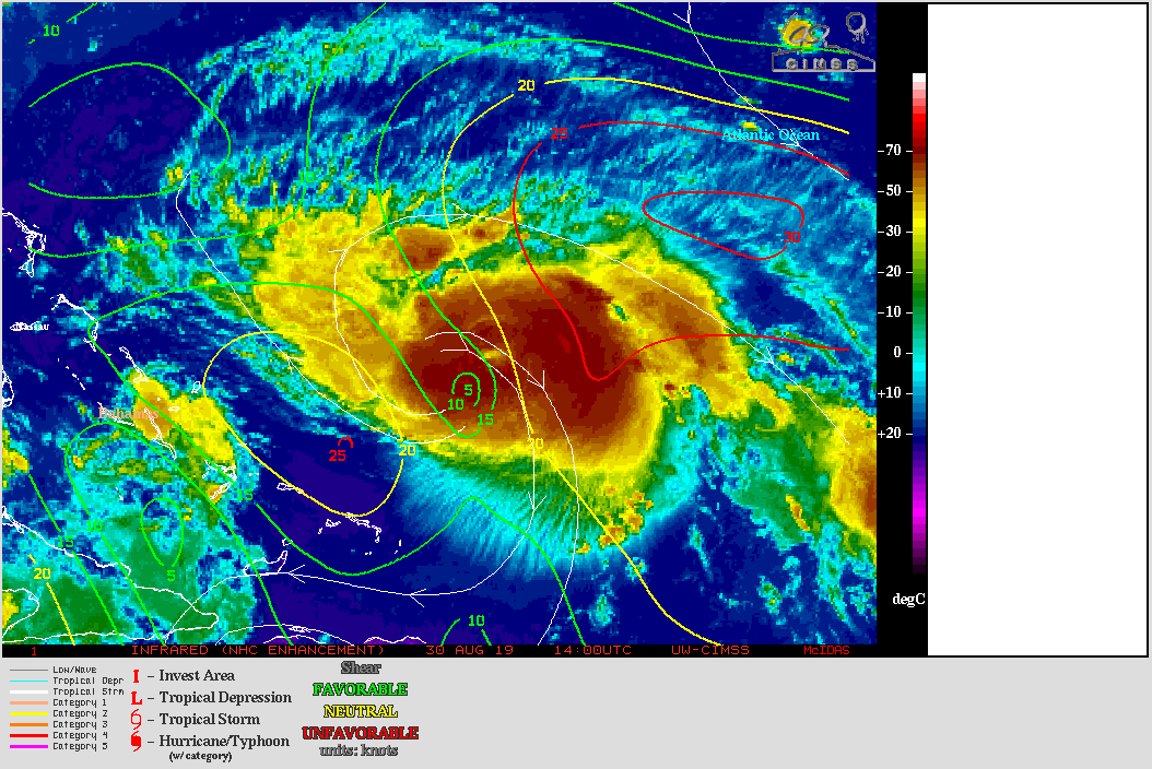
===== 31 August Update =====
![30-second GOES-16 “Red” Visible (0.64 µm) images [click to play animation | MP4]](https://cimss.ssec.wisc.edu/satellite-blog/wp-content/uploads/sites/5/2019/08/190831_goes16_visible_30second_Dorian_anim.gif)
30-second GOES-16 “Red” Visible (0.64 µm) images [click to play animation | MP4]
![GOES-16 “Red” Visible (0.64 µm) and “Clean” Infrared Window (10.35 µm) images [click to play animation | MP4]](https://cimss.ssec.wisc.edu/satellite-blog/wp-content/uploads/sites/5/2019/08/190831_goes16_infrared_30second_Dorian_anim.gif)
30-second GOES-16 “Clean” Infrared Window (10.35 µm) images [click to play animation | MP4]