One reason the “What the heck is this?” blog category was created was for situations when we struggle to provide a scientifically-sound explanation of interesting features seen on satellite imagery. Take for example the NOAA-17 AVHRR Infrared (10.8 µm) image (above): it shows what appears to be an elongated “warm... Read More
NOAA-17 Infrared (10.8 µm) image
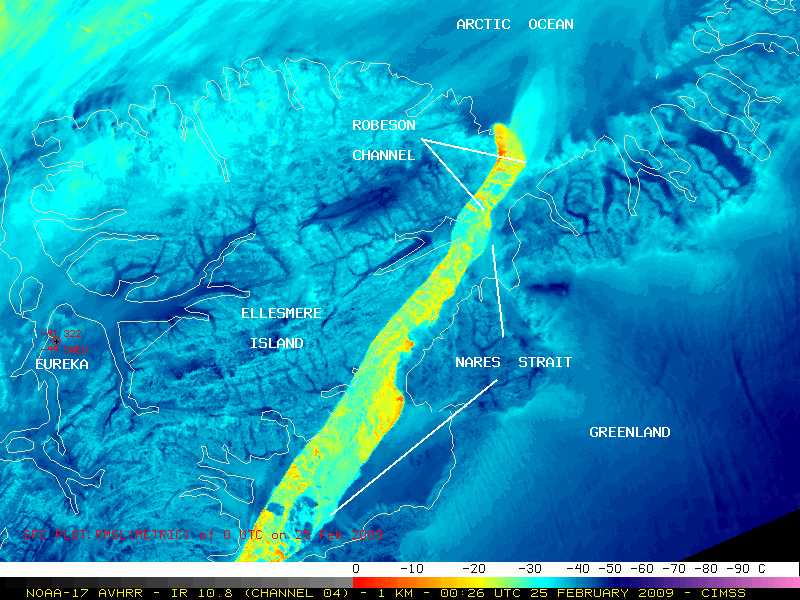
One reason the “What the heck is this?” blog category was created was for situations when we struggle to provide a scientifically-sound explanation of interesting features seen on satellite imagery. Take for example the NOAA-17 AVHRR Infrared (10.8 µm) image (above): it shows what appears to be an elongated “warm ice” signature over the northern half of the Nares Strait (which includes the Robeson Channel) that separates Canada’s Ellesmere Island (which covers much of the left half of the image) and Greenland (which covers much of the right half of the image). There are some cirrus clouds present over the far northwestern part of the image, but for the most part this is a cloud-free satellite scene. Most of the region exhibited very cold surface IR brightness temperatures in the -30º to -50ºC range (cyan to dark blue colors) — and the corresponding surface report from Eureka on Ellesmere Island (station identifier CWEU) showed a temperature of -41ºC (-42ºF). The daily high temperature at Eureka several hours later on 25 February 2009 was only -32ºC (-26ºF). Dress warmly if you have plans to visit Eureka over Spring Break.
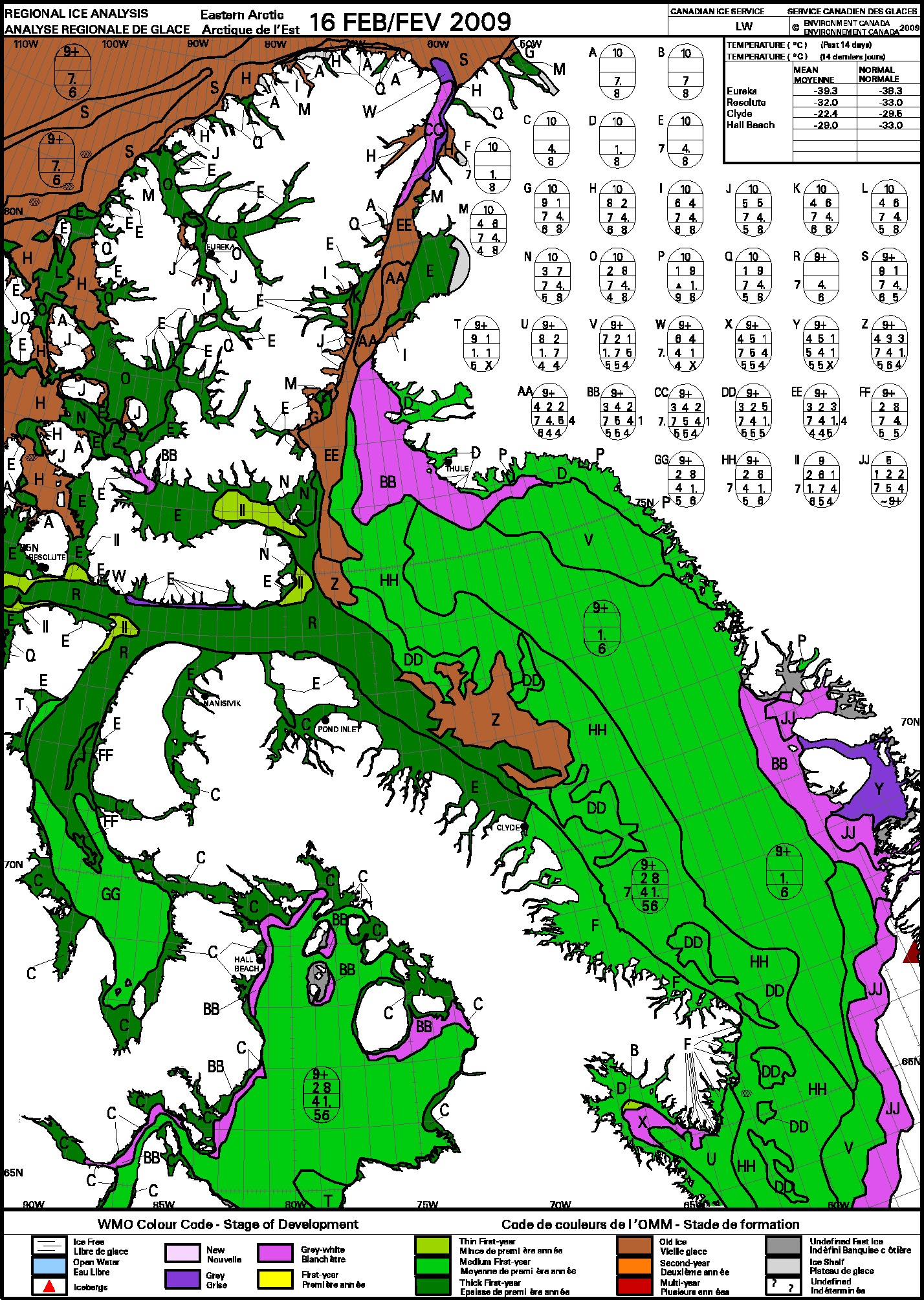
What is most striking about the image above is the elongated area of significantly warmer IR brightness temperatures over the (supposedly) ice-covered Nares Strait / Robeson Channel — IR values of -10º to -20ºC (orange to yellow colors) were seen over a large portion of that particular feature. With surface air temperatures so cold, it seems highly unlikely that the waters in that channel were becoming ice-free. The Canadian Ice Service regional ice analysis from 16 February (below) indicated that the ice coverage was 9/10 or greater in the area of the “warm signature” feature seen on satellite imagery — however, their ice analysis did indicate that anywhere from 2/10 to 6/10 of the total ice coverage consisted of relatively “young” ice (having a thickness of only 10-30 cm).

Canadian Ice Service regional ice analysis (16 February 2009)
So what would be the source such a warm signal on the IR satellite image: was there some sort of warm current of water beneath ice that would cause a significant amount of thermal energy to “bleed through” the (relatively thin) ice and be detected as warmer temperatures on the IR imagery? Was the ice thickness less than normal due to abnormally warm temperatures during the previous summer months, which increased the water temperatures enough to then slow the rate of ice formation during the winter?
In addition, it should be noted that the North Water Polynya is a seasonally-recurring area of ice-free or limited-ice water that forms in Baffin Bay (which connects to the far southern portion of the Nares Strait) — but would that polynya extend as far north into the Nares Strait as the Robeson Channel?
If you have any ideas, hypotheses, or conspiracy theories that would help to explain this curious satellite feature, we’d love to hear them — send us an email!
— 03 MARCH UPDATE —
I received an email from Trudy Wohlleben of the Canadian Ice Service, with a fantastic explanation of why we’re seeing such a “warm ice signature” on the satellite imagery:
This year (and the last two years) have been quite unusual. The ice in Nares Strait usually consolidates around the beginning of February, and normally you would not see an elongated warm signature extending right up the strait as you are seeing this winter. The ice then usually breaks up in the last week of July.
The normal (1971-2000) winter situation is shown on this map:
http://ice.ec.gc.ca/IA_NWCA_MCSI/ar_ctmed0301.gif , where black is 10/10 consolidated ice coverage and where red is mobile 9-10/10 ice coverage.
Nares Strait did not consolidate in 2007, allowing for a continuous flow of thick multi-year ice from the Arctic Ocean down to Baffin Bay. It did consolidate in 2008, but further north than normal (with the ice bridge starting at the north end of Kane Basin instead of in Smith Sound). This year, 2009, it hasn’t consolidated yet (again). So far (unlike 2007) an ice bridge HAS formed, preventing a flow of Arctic multi-year sea ice into the Strait. But (unlike 2008) it has formed at the far north end of Robeson Channel.
Because of the location of the ice bridge at the north end of Robeson Channel (instead of in the normal position in Smith Sound) and because of the prevailing northerly winds through the Strait, a polynya has formed extending the length of Nares Strait. The winds continuously push newly formed ice southwards, away from the ice bridge, keeping the ice at the north end of the Strait permanently broken and thin. Normally this polynya (The North Open Water or NOW polynya) forms at Smith Sound, with open water first appearing in mid-May to early-June (see: http://ice.ec.gc.ca/IA_NWCA_MCSI/ar_ctmed0611.gif).
Thanks, Trudy! So the mystery is solved — the “warm signature” seen on the 25 February IR image is due to the following: while there was indeed ice in the Nares Strait, much of that ice was fairly thin and broken, allowing a significant amount of thermal energy from the underlying water to pass upward through the ice and be detected by the satellite IR sensors. In a “normal” winter, we would not be seeing such a strong “warm signature” in the Nares Strait as early as the end of February. Something to think about for the Climate Change naysayers, I suppose…
View only this post
Read Less


