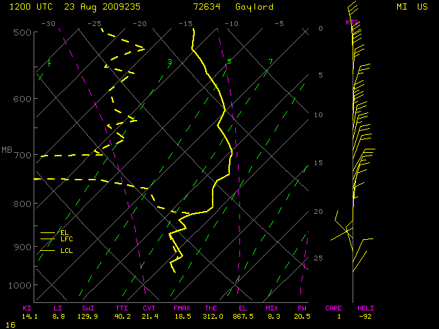
This website works best with a newer web browser such as Chrome, Firefox, Safari or Microsoft Edge. Internet Explorer is not supported by this website.

Tropical Storm Hanna

Tropical Storm Hanna exhibited some interesting satellite imagery features on 02 September 2008. GOES-13 IR images (above) displayed a period of transverse banding during the 01-05 UTC period — this transverse banding is a satellite signature of potential turbulence (although  no aircraft... Read More

GOES-13 10.7 µm IR images

GOES-13 10.7 µm IR images

Tropical Storm Hanna exhibited some interesting satellite imagery features on 02 September 2008. GOES-13 IR images (above) displayed a period of transverse banding during the 01-05 UTC period — this transverse banding is a satellite signature of potential turbulence (although  no aircraft reports of turbulence were received from that region, since pilots generally try to avoid flying over tropical storms). Very cold cloud top brightness temperatures were observed prior to the period of banding, with values in the -80º to -89º C range (light purple to dark purple colors).

GOES-13 10.7 µm IR images

GOES-13 10.7 µm IR images

Later in the morning, an interesting “shear axis” or “deformation zone” signature was noted in the vicinity of Hanna, which was marked by a thin band of clouds oriented SW-NE. GOES-13 IR imagery (above) and visible imagery (below) showed that this shear axis was subsequently deformed  and eroded by a burst of  convective development near the center of Hanna.

GOES-13 visible images

GOES-13 visible images

A deep-layer wind shear analysis from the CIMSS Tropical Cyclones site (below) showed that strong northwesterly outflow from the remnants of Hurricane Gustav were impinging upon Tropical Storm Hanna, helping to reinforce the shear axis / deformation zone.

GOES-12 water vapor image + wind shear

GOES-12 water vapor image + wind shear

An AVHRR false-color composite image (below; viewed using Google Earth) showed that the tropics were becoming fairly active, with Tropical Depression Karina in the East Pacific and Tropical Depression Gustav over the continental US, and Tropical Storm Hanna, Invest Area 90L, Tropical Storm Ike, and Tropical Storm Josephine in the Atlantic basin on 02 September 2008.

AVHRR false color composite image (viewed using Google Earth)

AVHRR false color composite image (viewed using Google Earth)

View only this post Read Less

Rapid intensification of Hurricane Gustav

Hurricane Gustav underwent a period of rapid intensification during the daytime hours on 30 August 2008 (as seen on a plot of the CIMSS Advanced Dvorak Technique), reaching Category 4 intensity. AWIPS images of the GOES-12 10.7 µm IR channel (above) revealed an impressive eye structure on 30 August,... Read More

GOES-12 IR images  (Animated GIF)

AWIPS images of GOES-12 10.7 µm IR channel

Hurricane Gustav underwent a period of rapid intensification during the daytime hours on 30 August 2008 (as seen on a plot of the CIMSS Advanced Dvorak Technique), reaching Category 4 intensity. AWIPS images of the GOES-12 10.7 µm IR channel (above) revealed an impressive eye structure on 30 August, which subsequently degraded in appearance on 31 August (as Gustav’s interaction with Cuba apparently took a toll on the tropical cyclone). Large-format IR animations are also available: 32 MB Animated GIF | 16MB QuickTime movie.

High-resolution atmospheric motion vectors (AMVs) produced once per hour (below) showed the well-defined upper-tropospheric outflow within the northern semi-circle of the storm as it crossed Cuba and moved into the Gulf of Mexico. The upper-tropospheric winds associated with Tropical Storm Hanna could also be seen farther to the east, over the Atlantic Ocean.

GOES-12 IR images + atmospheric motion vectors (Animated GIF)

GOES-12 IR images + atmospheric motion vectors

On 31 August, early morning QuikSCAT data showed the broad wind field associated with the Category 3 storm, while a late-morning AWIPS image of the 1-km resolution MODIS 11.0 µm IR channel data (below) revealed a subtle hint of an eye structure with a ring of colder clouds at 16:34 UTC — cloud top brightness temperature values at that time were as cold as -87º C (darker purple enhancement).

AWIPS image of MODIS 11.0 µm IR channel data

AWIPS image of MODIS 11.0 µm IR channel data

During the remainder of the day on 31 August, there was some evidence of an eye structure on polar-orbiting satellite (POES) microwave imagery, even though no eye was obvious on conventional geostationary satellite (GOES) visible or IR imagery (below, courtesy of the CIMSS Tropical Cyclones site).

POES microwave image + GOES-12 IR image

POES microwave image + GOES-12 IR image

Gustav eventually made landfall in Louisiana as a strong Category 2 hurricane on 01 September 2008 (below).

GOES-12 IR montage of Gustav

GOES-12 IR montage of Gustav

View only this post Read Less

Smoke over the Foothills of Colorado

A comparison of GOES-11 and GOES-13 visible images (above) showed that some smoke aloft (from wildfires that had been burning in parts of the northern Rocky Mountains) was drifting over the Foothills region of eastern Colorado during the morning hours on 28... Read More

GOES-11 + GOES-13 visible images (Animated GIF)

GOES-11 + GOES-13 visible images

A comparison of GOES-11 and GOES-13 visible images (above) showed that some smoke aloft (from wildfires that had been burning in parts of the northern Rocky Mountains) was drifting over the Foothills region of eastern Colorado during the morning hours on 28 August 2008. Northwesterly winds aloft were  blowing a good deal of the smoke toward the southeast, but some smoke at lower levels could be seen moving southwestward and backing up against the higher terrain (a result of  upslope winds in the wake of a cold frontal passage  on the previous day). Both the Denver, Colorado rawinsonde report and the Platteville, Colorado NOAA wind profiler data indicated the northeasterly upslope flow was restricted to the lowest 1 km or so of the atmosphere.

A similar comparison of GOES-12 and GOES-13 images during the afternoon hours (below) showed that  the low-level smoke was still backed up against the Foothills, but was also beginning to slowly drift toward the north as the boundary layer winds began to acquire more of a southerly component. Note that the surface features on the GOES-13 animations exhibit less image-to-image movement compared to both GOES-11 and GOES-12 — improvements to the GOES-13 spacecraft Image Navigation and Registration (INR) system  include the use of star trackers to provide more precise image navigation.

GOES-12 + GOES-13 visible images data

GOES-12 + GOES-13 visible images

The smoke was easier to identify using 250-m resolution MODIS true color imagery from the SSEC MODIS Today site (below), and this smoke was also evident on the MODIS Aerosol Optical Depth product.

MODIS true color image

MODIS true color image

The Denver National Weather Service forecast discussion mentioned the smoke:

AREA FORECAST DISCUSSION
NATIONAL WEATHER SERVICE DENVER CO
315 PM MDT THU AUG 28 2008

.AVIATION…VFR CONDITIONS TO CONTINUE THROUGH TONIGHT. SMOKE OVER AREA HAS BEEN CREATING SOME SLANT VISIBILITY PROBLEMS UPON APPROACH AS WELL AS TAKE OFFS…BUT NO CONCERNS WITH SURFACE VISIBILITY. IT DOESN`T APPEAR THAT SURFACE VISIBILITY WILL BE REDUCED.

While there were a couple of pilot reports of haze aloft over the region around 18:00 UTC, at altitudes of 11,500  and 14,000 feet (below), the surface visibilities only dropped to 6 miles at Boulder (KBJC) and 7 miles at Denver (KDEN)  during the afternoon hours, and remained around 10 miles at other surrounding airports.

AWIPS images of the MODIS visible channel

AWIPS images of the MODIS visible channel

View only this post Read Less

Running a forecast model with locally downloaded satellite data

MODIS instruments (see here, as well) on board NASA’s Terra and Aqua satellites offer high resolution multi-banded views of the Earth’s atmosphere. Information from the channels can be used to derive total precipitable water in regions where clouds do not exist (as explained here). In the present case, MODIS TPW... Read More

McIDAS-V images of CRAS model Precipitable Water

McIDAS-V images of CRAS model Precipitable Water pre-forecast spin-up

MODIS instruments (see here, as well) on board NASA’s Terra and Aqua satellites offer high resolution multi-banded views of the Earth’s atmosphere. Information from the channels can be used to derive total precipitable water in regions where clouds do not exist (as explained here). In the present case, MODIS TPW is compared to colocated TPW values in a CRAS model run that is centered on the direct broadcast MODIS ground station site at SSEC. Where the values differ, mixing ratios are adjusted so that the model value more closely matches the satellite-observed TPWs (Lapse rates are preserved in the adjustment). Satellite-observed TPWs are available only in clear fields of view; cloud initializations, however, are adding information where clouds are observed.

The case above (imagery produced using McIDAS-V) shows the 12-hour pre-forecast spin-up for the model with an initial time of 12:00 UTC on 25 August 2008. Six different MODIS orbits that were received at the SSEC direct broadcast ground station between 00:00 UTC and 12:00 UTC directly affect the initial model fields that are derived from GFS output. Note how the addition of MODIS data moistens the atmosphere in and around the remains of Tropical Storm Fay over the south central US, and also moistens the atmosphere over the Pacific Ocean west of California.

This method is used to introduce satellite information downloaded locally into a model run; more accurate initial fields are helpful in producing a more accurate forecast. In the present case, once the more accurate initial fields are generated, the model then steps forward in time (with GFS fields used to constrain the boundaries).

View only this post Read Less