This website works best with a newer web browser such as Chrome, Firefox, Safari or Microsoft Edge. Internet Explorer is not supported by this website.

Transverse banding: a satellite signature of potential turbulence

AWIPS images of the GOES-12 10.7 µm IR channel (above) revealed 2 separate periods where packets of “transverse banding” (thin, banded cloud elements oriented perpendicular to the ambient flow) were forming over parts of Florida, Alabama, and Georgia on 07 March 2008. These transverse bands were located at high altitudes along the... Read More

GOES-12 IR images (Animated GIF)

AWIPS images of the GOES-12 10.7 µm IR channel (above) revealed 2 separate periods where packets of “transverse banding” (thin, banded cloud elements oriented perpendicular to the ambient flow) were forming over parts of Florida, Alabama, and Georgia on 07 March 2008. These transverse bands were located at high altitudes along the western edge of the large convective cloud mass that was moving across the region; severe thunderstorms along the eastern flank of this line produced several tornadoes in northern Florida and southern Georgia (including a tornado responsible for 2 fatalities near Lake City, Florida).

A comparison of the 4-km resolution GOES-12 IR image at 16:32 UTC with the 1-km resolution NOAA-17 AVHRR IR image at 16:20 UTC (below) shows a closer view of one area of transverse banding moving over the Florida panhandle region, and demonstrates that more accurate identification of this type of small-scale cloud feature is possible with improved spatial resolution satellite imagery. The IR channels available on the Advanced Baseline Imager (ABI) instrument on GOES-R will provide 2-km resolution data, which should improve the ability to detect subtle features such as transverse banding.

GOES-12 + NOAA-17 IR images

There were large areas across the southeastern US that were covered by aviation AIRMET (Airmen’s Meteorological Information) turbulence advisories (outlined in yellow, below), but these advisories were for locations a bit farther to the west than the transverse banding seen on the satellite imagery. In fact, there were indeed a couple of pilot reports of high-altitude turbulence indicated near the regions of transverse banding.

GOES-12 IR image + aviation advisories

In addition to the AIRMET advisories, there was also a SIGMET (Significant Meteorological Information, outlined in red) that had been issued due to isolated aircraft reports of severe to extreme turbulence at the 28,000-29,000 feet altitude range over northern Alabama and western Tennessee during the 15:00-16:00 UTC period. Note that there were also some transverse banding signatures evident in the patch of cloud that was located over northern Mississippi at that time — once again, the structure of these banded cloud features was much more obvious when viewed using the 1-km resolution NOAA-17 AVHRR IR imagery (below).

NOAA-17 + GOES-12 IR images

On that same day, a Lufthansa Airbus A340 passenger jet flying from Frankfurt, Germany to Atlanta, Georgia encountered severe turbulence around 19:15 UTC, at an altitude of 36,300 feet (while over the Atlantic Ocean, about 80 nautical miles southeast of Charleston, South Carolina):

CHS UUA /OV 80SE CHS/TM 1915/FL363/TP HA343/TB SEV FL350-FL363/RM CLIMB 130 FT ZJX=

The aircraft apparently lost about 1300 feet of altitude after encountering the severe turbulence. Ten persons aboard that flight received injuries (with a few requiring hospitalization), and the plane landed with priority clearance at Atlanta around 20:07 UTC. While the GOES-12 10.7 µm IR imagery in the vicinity of the incident (below) did not exhibit any of the transverse banding signatures that were seen farther inland, there were some rapidly developing thunderstorms in the vicinity (around 80 nautical miles southeast of Charleston, CHS) that likely contributed to the high-altitude turbulence. Note that the Lufthansa pilot report of turbulence did not show up in the database that was plotted by the McIDAS software shown below, but it was plotted by the AWIPS software (although in the wrong location, directly over Charleston, instead of 80 miles southeast of CHS).

GOES-12 IR images (Animated GIF)

View only this post Read Less

Snow in Texas, Oklahoma, Arkansas, and Missouri

Several inches of snow fell in parts of Texas, Oklahoma, Arkansas, and Missouri during the evening of 03 March 2008 into the morning of 04 March 2008 — snowfall amounts included 8.5 inches at Springfield, Missouri, 8.0 inches at Broken Arrow, Oklahoma, 6.0 inches at Bella Vista, Arkansas, and 5.0 inches at Pottsville, Texas.... Read More

GOES-12 6.5 µm water vapor images (Animated GIF)

Several inches of snow fell in parts of Texas, Oklahoma, Arkansas, and Missouri during the evening of 03 March 2008 into the morning of 04 March 2008 — snowfall amounts included 8.5 inches at Springfield, Missouri, 8.0 inches at Broken Arrow, Oklahoma, 6.0 inches at Bella Vista, Arkansas, and 5.0 inches at Pottsville, Texas. Snow was even reported briefly at Shreveport in far northwestern Louisiana, and the 1.0 inch of snow at Dallas-Ft. Worth in Texas set a new daily snowfall record for 03 March. GOES-12 6.5 µm water vapor images (above) show that many of the reports of snow (along with some rain and freezing rain) were occurring along the periphery of a well-defined dry slot that was advancing northeastward from Texas into Arkansas. In addition, a deformation zone just northwest of the dry slot was also acting to help organize the southwest-to-northeast oriented banded structure of the resulting precipitation.

AWIPS images of the GOES sounder Total Column Ozone product (below) depicted a lobe of high values of ozone (greater than 400 Dobson units, red colors) associated with the sharp trough aloft that was swinging eastward across the southern and central Plains. Such elevated ozone levels are often seen in regions where the tropopause altitude is quite low — in fact, the NAM fields indicated that the “dynamic tropopause” (taken to be the pressure level of the 1.5 Potential Vorticity Unit surface) was as low as the 700 hPa pressure level at 12:00 UTC.

GOES sounder total comumn ozone (Animated GIF)

GOES-12 visible images from the following morning (below) revealed several large patches of snow-covered ground as the clouds began to retreat eastward. Note the aforementioned southwest-to-northeast orientation of the bands of snow cover in Oklahoma, Arkansas, and Missouri. The snow on the ground melted quickly under the warmth of the March sun, eroding quickly from the edges inward on the visible satellite imagery. Also, if you look closely, you can see a small puff of smoke move northward from a fire that was burning briefly in west-central Oklahoma (toward the end of the animation).

GOES-12 visible images (Animated GIF)

If we compare 
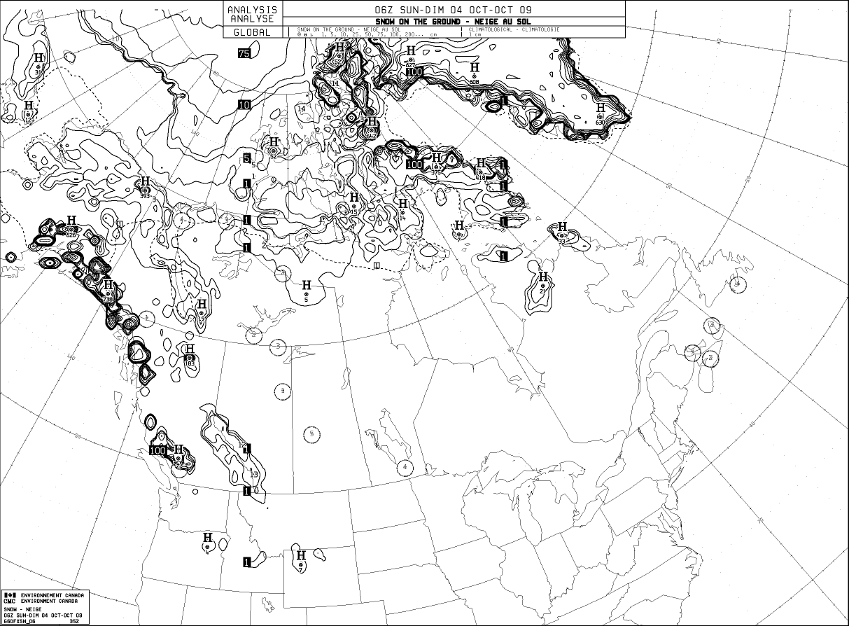
AWIPS images of the MODIS visible channel and the 2.1 µm near-IR “snow/ice channel” at 16:57 UTC 0r 11:57 am local time (below), we see that both clouds and patches of snow cover appear as brighter white features on the visible channel image; however, on the snow/ice image the snow cover features appear much darker (in contrast to the much lighter appearance of supercooled water droplet clouds). Cloud features in Missouri and Arkansas that were composed of ice crystals also appear darker on the snow/ice channel image.

MODIS visible + snow/ice images (Animated GIF)

View only this post Read Less

The Gulf Stream: MODIS vs. RTG_SST_HR model Sea Surface Temperature

Minimal cloud cover (MODIS true color image) off the US East Coast and over the western North Atlantic Ocean on 03 March 2008 allowed a nice view of the ribbon of warm water temperatures associated with the Gulf Stream, as shown on an AWIPS image of the MODIS Sea Surface Temperature (SST) product at 17:56 UTC... Read More

MODIS + RGT_SST analysis (Animated GIF)

Minimal cloud cover (MODIS true color image) off the US East Coast and over the western North Atlantic Ocean on 03 March 2008 allowed a nice view of the ribbon of warm water temperatures associated with the Gulf Stream, as shown on an AWIPS image of the MODIS Sea Surface Temperature (SST) product at 17:56 UTC (above). MODIS SST values along the Gulf Stream were generally in the 72-79º F (22-26º C) range (yellow to orange colors); clouds over water are depicted with as black on the MODIS SST product. A comparison with the SST analysis field from the High Resolution Real Time Global (RTG_SST_HR) model 18 hours earlier (at 00:00 UTC) demonstrated the advantage of the 1-km resolution MODIS data for resolving the small-scale detail in the structure of warm and cold water eddies that existed on either side of the Gulf Stream axis.

In particular, note Buoy 41002, located south of Cape Hatteras, North Carolina (or about 250 nautical miles east of Charleston, South Carolina): the National Data Buoy Center water temperature data for 41002 (below) revealed that the SST had increased 7-8º F since 29 February 2008 as an eddy of warm water drifted across the buoy location, and the water temperature was in the 74-75º F range during the daytime hours on 03 March. The 17:56 UTC MODIS SST value of 74.2º F in the vicinity of Buoy 41002 was in much better agreement with the NDBC water temperature data (compared to the SST value of less than 69º F at Buoy 41002 indicated by the RTG_SST_HR analysis at 00:00 UTC).

Buoy 41002 SST data

At its greatest, the Gulf Stream is about 100 miles wide and several hundred feet deep — much larger than any river on Earth. It also moves much faster than any river, moving as much as about 140 miles in a single day; in terms of volume per second, the Gulf Stream moves about 1000 times faster than the Mississippi River.

View only this post Read Less

Wildfires in Texas

Several large wildfires began to burn across parts of western Texas (and also southeastern New Mexico) late in the day on 25 February 2008, as seen by the large number of fire “hot spots” (black to red pixels, with red being the hottest temperatures) on GOES-12 3.9 µm “shortwave IR” images (above).... Read More

GOES-12 3.9µm IR images (Animated GIF)

Several large wildfires began to burn across parts of western Texas (and also southeastern New Mexico) late in the day on 25 February 2008, as seen by the large number of fire “hot spots” (black to red pixels, with red being the hottest temperatures) on GOES-12 3.9 µm “shortwave IR” images (above). Strong northerly winds — gusting as high as 67 mph (30 m s-1) at Guadalupe Pass, 51 mph (23 m s-1) at Midland, and 45 mph (20 m s-1) at San Angelo — helped the grass fires quickly grow out of control and spread rapidly southward; this extreme fire growth was evident by the fast rate of increase in areal coverage of “hot” black-to-red pixels on the shortwave IR imagery. Very warm surface air temperatures were also noted across Texas on that day, with a high of 93º F (34º C) at San Angelo and a high of 99ºF (37º C) at Del Rio (which tied the all-time record high for the month of February at that location).

MODIS + GOES-12 shortwave IR images

A comparison of the 1-km resolution MODIS 3.7 µm IR image with the corresponding 4-km resolution GOES-12 3.9 µm IR image (above) as the fire intensity and coverage was beginning to diminish around 05:00 UTC or Midnight local time (near the end of the GOES-12 shortwave IR animation shown at the beginning of this post) demonstrates the superior fire detection capability offered by the improvement in spatial resolution on the MODIS instrument. The largest of the active fires was located to the west/northwest of San Angelo (station identifier KSJT), and hot pixels associated with this large fire (black to red enhancement) could be seen across parts of several different counties.

MODIS true color image (Google Earth)

An extensive burn scar resulting from the largest fire (the “Glass Fire”, which was located between San Angelo and Midland) was apparent on MODIS true color imagery (viewed using Google Earth, above) two days later (on 27 February 2008). In fact, one small fire was still burning along the southeastern periphery of the burn scar, with a subtle smoke plume seen drifting northeastward toward Highway 87. The Glass Fire burned over 219,000 acres in Sterling county alone (InciWeb).

View only this post Read Less