
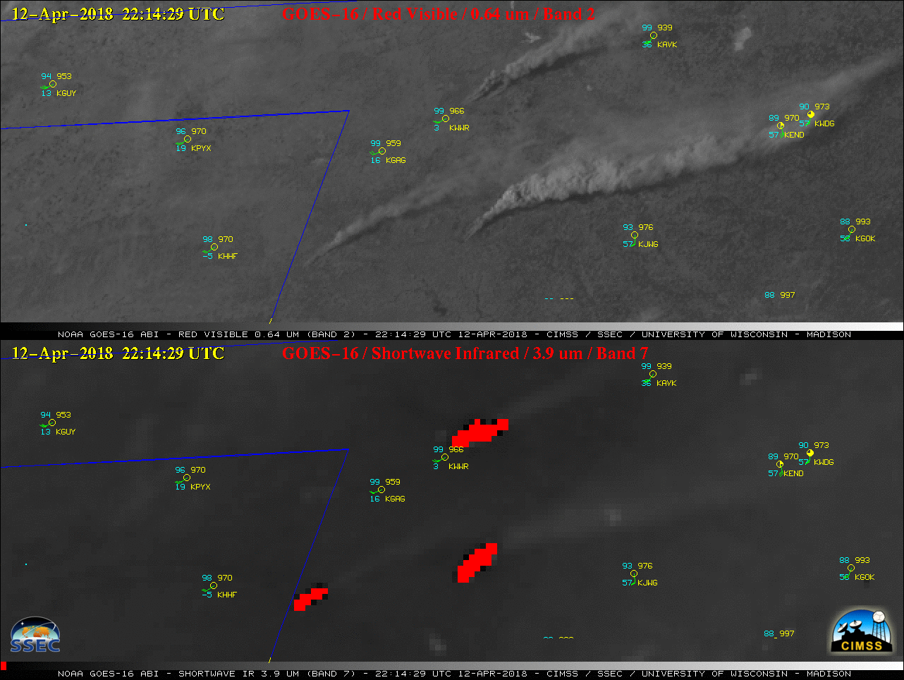
1-minute Mesoscale Sector GOES-16 (GOES-East) “Red” Visible (0.64 µm) and Shortwave Infrared (3.9 µm) images (above) showed the development and rapid spread of grass fires in northwest Oklahoma on 12 April 2018. Hot fire pixels are highlighted as red on the Shortwave Infrared images — and the rapid northeastward run of the larger fires was... Read More
GOES-16 “Red” Visible (0.64 µm, top) and Shortwave Infrared (3.9 µm, bottom) images, with hourly plots of surface reports [click to play MP4 animation]
1-minute
Mesoscale Sector GOES-16
(GOES-East) “Red” Visible (
0.64 µm) and Shortwave Infrared (
3.9 µm) images
(above) showed the development and rapid spread of grass fires in northwest Oklahoma on
12 April 2018. Hot fire pixels are highlighted as red on the Shortwave Infrared images — and the rapid northeastward run of the larger fires was very evident. The intense heat of the fires produced pyrocumulus clouds, which could be seen on the Visible images. Additional images are available on the
Satellite Liaison Blog.
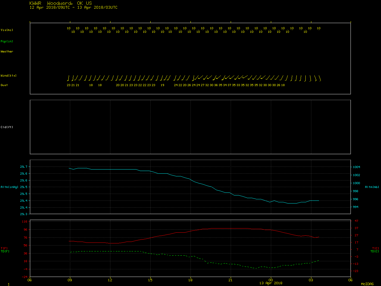
SPC had highlighted parts of New Mexico, Colorado, Texas and Oklahoma as having conditions favorable for Extreme wildfire behavior due to strong winds, hot temperatures and very dry air behind a dryline boundary (below). Note that the surface temperature / dew point depression at Woodward, Oklahoma (KWWR) at 2255 UTC on 12 April was 100 ºF (temperature = 97 ºF, dew point = -2 ºF), with southwesterly winds gusting to 35 knots or 40 mph.
![SPC Day 1 Fire Outlook [click to enlarge]](https://cimss.ssec.wisc.edu/satellite-blog/wp-content/uploads/sites/5/2018/04/180412_spc_day1_fire_outlook.jpeg)
SPC Day 1 Fire Outlook [click to enlarge]
===== 13 April Update =====
![Suomi NPP VIIRS Day/Night Band (0.7 µm) and Shortwave Infrared (3.9 µm) images [click to enlarge]](https://cimss.ssec.wisc.edu/satellite-blog/wp-content/uploads/sites/5/2018/04/180413_0837utc_suomi_npp_viirs_ShortwaveInfrared_DayNightBand_OK_fires_anim.gif)
Suomi NPP VIIRS Day/Night Band (0.7 µm) and Shortwave Infrared (3.9 µm) images [click to enlarge]
The fires in northwestern Oklahoma continued to burn into the following night — Suomi NPP VIIRS Day/Night Band (0.7 µm) and Shortwave Infrared (3.9 µm) images at 0837 UTC or 3:37 AM local time
(above) revealed the bright glow and hot fire pixels associated with the 2 large fire complexes in Woodward County (
34 Complex Fire) and Dewey County (
Rhea Fire). At least 2 fatalities (
Wildfire Today |
media report) have been attributed to the larger and longer-burning Rhea Fire in Dewey County (which had burned an estimated 241,280 acres by mid-day on 14 April).
During the following daytime hours of 13 April, GOES-16 “Red” Visible (0.64 µm) and Shortwave Infrared (3.9 µm) images (below) showed the smoke plumes and hot pixels of the northwestern Oklahoma fires. The surface cold front moved over these fires around 18 UTC, with smoke transport transitioning more toward the east then southeast.
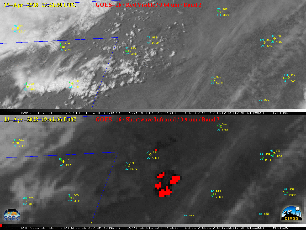
GOES-16 “Red” Visible (0.64 µm, top) and Shortwave Infrared (3.9 µm, bottom) images, with hourly plots of surface reports [click to play MP4 animation]
Farther to the southwest, new grass fires which began burning west of the Texas/Oklahoma border after 17 UTC quickly raced eastward and crossed the border into southwestern Oklahoma after 20 UTC
(below).
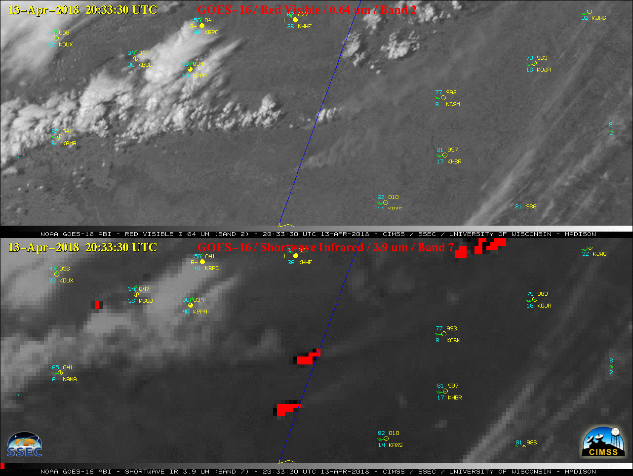
GOES-16 “Red” Visible (0.64 µm, top) and Shortwave Infrared (3.9 µm, bottom) images, with hourly plots of surface reports [click to play MP4 animation]
===== 14 April Update =====
Three nighttime comparisons of (Preliminary, non-operational) NOAA-20 and Suomi NPP VIIRS Day/Night Band (0.7 µm) and Shortwave Infrared (3.75 µm) images — each image pair separated by 50 minutes — (below; courtesy of William Straka, CIMSS) showed the bright glow and thermal hot spots of the ongoing Rhea fire complex.
![NOAA-20 VIIRS Day/Night Band (0.7 µm) and Shortwave Infrared (3.75 µm) images at 0737 UTC [click to enlarge]](https://cimss.ssec.wisc.edu/satellite-blog/wp-content/uploads/sites/5/2018/04/180414_0737utc_viirs_DayNightBand_ShortwaveIR_NW_OK_fires_anim.gif)
NOAA-20 VIIRS Day/Night Band (0.7 µm) and Shortwave Infrared (3.75 µm) images at 0737 UTC [click to enlarge]
![Suomi NPP VIIRS Day/Night Band (0.7 µm) and Shortwave Infrared (3.75 µm) images [click to enlarge]](https://cimss.ssec.wisc.edu/satellite-blog/wp-content/uploads/sites/5/2018/04/180414_0827utc_viirs_DayNightBand_ShortwaveIR_NW_OK_fires_anim.gif)
Suomi NPP VIIRS Day/Night Band (0.7 µm) and Shortwave Infrared (3.75 µm) images [click to enlarge]
![NOAA-20 VIIRS Day/Night Band (0.7 µm) and Shortwave Infrared (3.75 µm) images [click to enlarge]](https://cimss.ssec.wisc.edu/satellite-blog/wp-content/uploads/sites/5/2018/04/180414_0917utc_viirs_DayNightBand_ShortwaveIR_NW_OK_fires_anim.gif)
NOAA-20 VIIRS Day/Night Band (0.7 µm) and Shortwave Infrared (3.75 µm) images [click to enlarge]
===== 15 April Update =====
250-meter resolution Terra MODIS true-color and false-color Red-Green-Blue (RGB) images from MODIS Today (below) showed the burn scars from the 34 Complex and the larger Rhea Fire at 1719 UTC on 15 April 2018.
![Terra MODIS true-color and false-color RGB images [click to enlarge]](https://cimss.ssec.wisc.edu/satellite-blog/wp-content/uploads/sites/5/2018/04/180415_1719utc_terra_modis_truecolor_falsecolor_northwestern_OK_fires_anim.gif)
Terra MODIS true-color and false-color RGB images [click to enlarge]
View only this post
Read Less
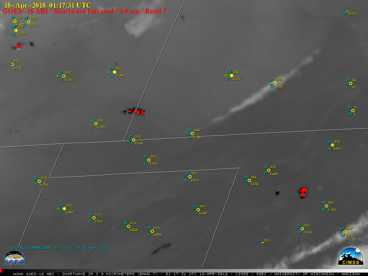
![GOES-16 Shortwave Infrared (3.9 µm) images, with hourly plots of surface reports [click to play MP4 animation]](https://cimss.ssec.wisc.edu/satellite-blog/wp-content/uploads/sites/5/2018/04/G16_SWIR_FIRES_CO_OK_17APR2018_960x1280_B7_2018107_235931_0001PANEL_00480.GIF)
![GOES-16 Shortwave Infrared (3.9 µm) images, with hourly plots of surface reports [click to play MP4 animation]](https://cimss.ssec.wisc.edu/satellite-blog/wp-content/uploads/sites/5/2018/04/G16_SWIR_FIRES_CO_OK_ZOOM_17APR2018_960x1280_B7_2018108_011731_0001PANEL_00378.GIF)
![NOAA-20 Day/Night Band (0.7 µm), I-Band Shortwave Infrared (3.75 µm), M-Band Shortwave Infrared (4.05 µm), M-Band Near-Infrared (1.61 µm and 2.25 µm) images [click to enlarge]](https://cimss.ssec.wisc.edu/satellite-blog/wp-content/uploads/sites/5/2018/04/180418_0802utc_noaa20_viirs_Rhea_Fire_OK_anim.gif)
![Aqua MODIS Land Surface Temperature product [click to enlarge]](https://cimss.ssec.wisc.edu/satellite-blog/wp-content/uploads/sites/5/2018/04/MODIS_LST_20180418_1919_OK.png)
![Landsat-8 false-color image [click to enlarge]](https://cimss.ssec.wisc.edu/satellite-blog/wp-content/uploads/sites/5/2018/04/180419_1725utc_landsat8_falsecolor_BadgerHoleFire_CO_KS_burn_scar.jpeg)
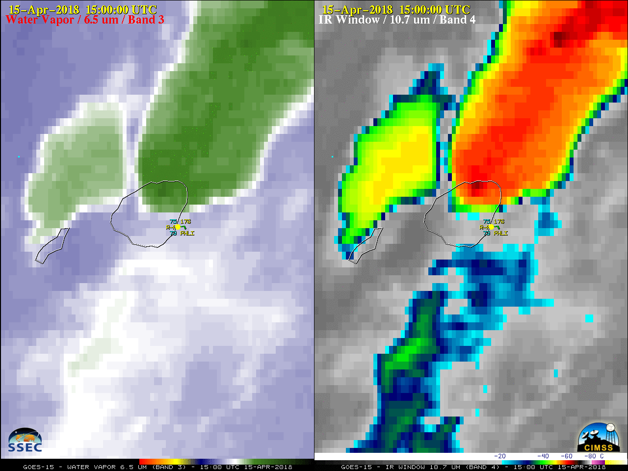
![GOES-15 Water Vapor (6.5 µm, left) and Infrared Window (10.7 µm, right) images, with hourly plots of surface reports [click to play MP4 animation]](https://cimss.ssec.wisc.edu/satellite-blog/wp-content/uploads/sites/5/2018/04/G15_WV_IR_KAUAI_15APR2018_958x638_B34_2018105_150000_0002PANELS_00032.GIF)
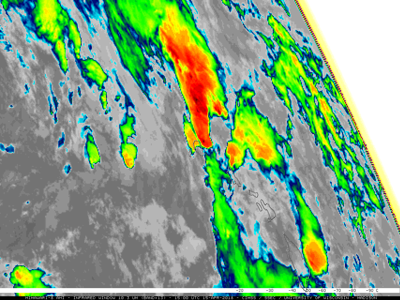
![Himawari-8 Water Vapor (6.9 µm, left) and Infrared Window (10.4 µm, right) images, with hourly plots of surface reports [click to play MP4 animation]](https://cimss.ssec.wisc.edu/satellite-blog/wp-content/uploads/sites/5/2018/04/AHIM08_WV_IR_KAUAI_15APR2018_958x638_B913_2018105_150000_0002PANELS_00054.GIF)
![MIMIC Total Precipitable Water product [click to play animation]](https://cimss.ssec.wisc.edu/satellite-blog/wp-content/uploads/sites/5/2018/04/180414_180416_mimic_tpw_EPAC_anim.gif)
![GOES-15 Water Vapor (6.5 µm) images with mid/upper level atmospheric motion vectors [click to play animation]](https://cimss.ssec.wisc.edu/satellite-blog/wp-content/uploads/sites/5/2018/04/180414_180415_goes15_upper_level_winds_East_Pacific_anim.gif)
