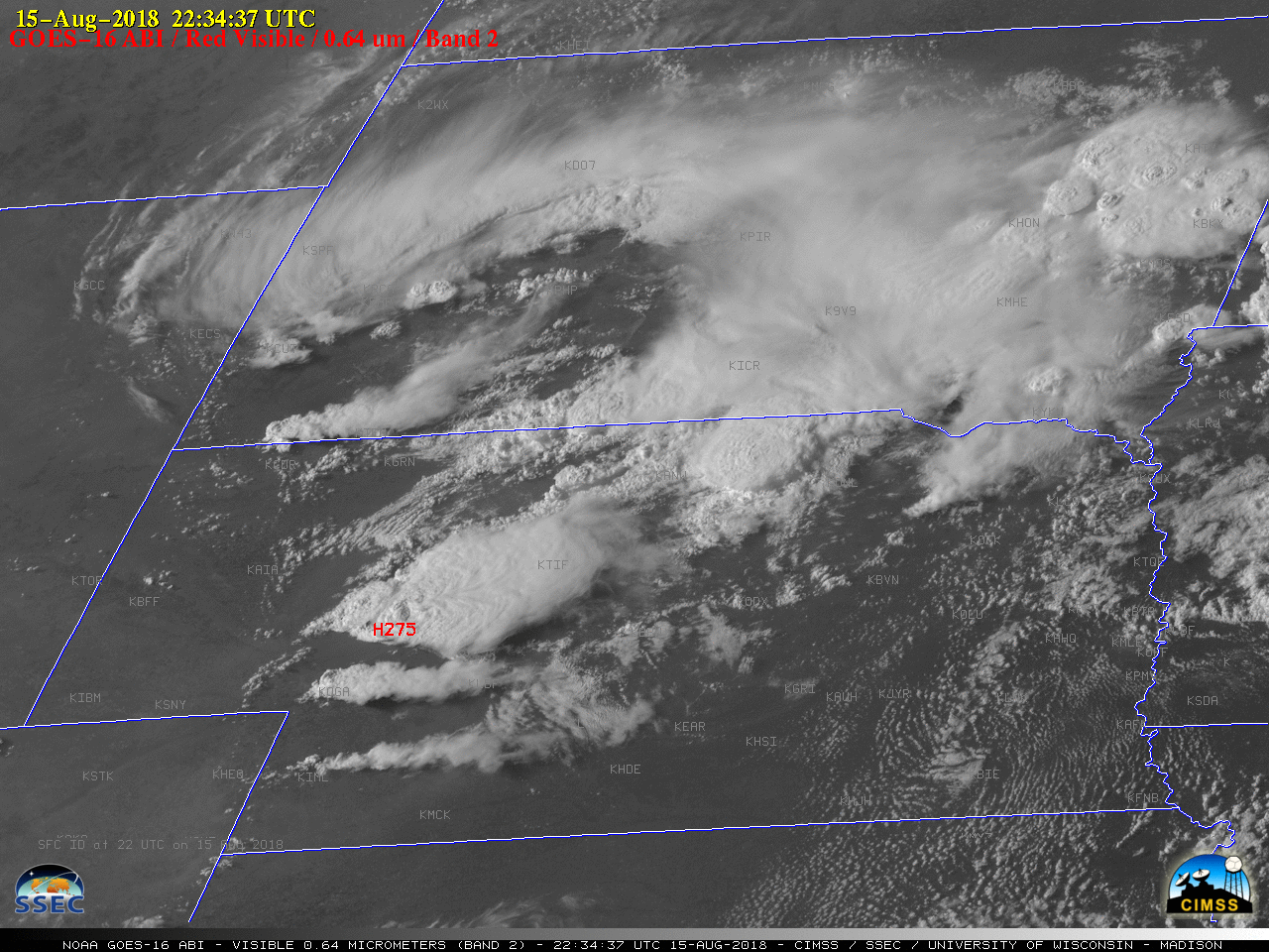
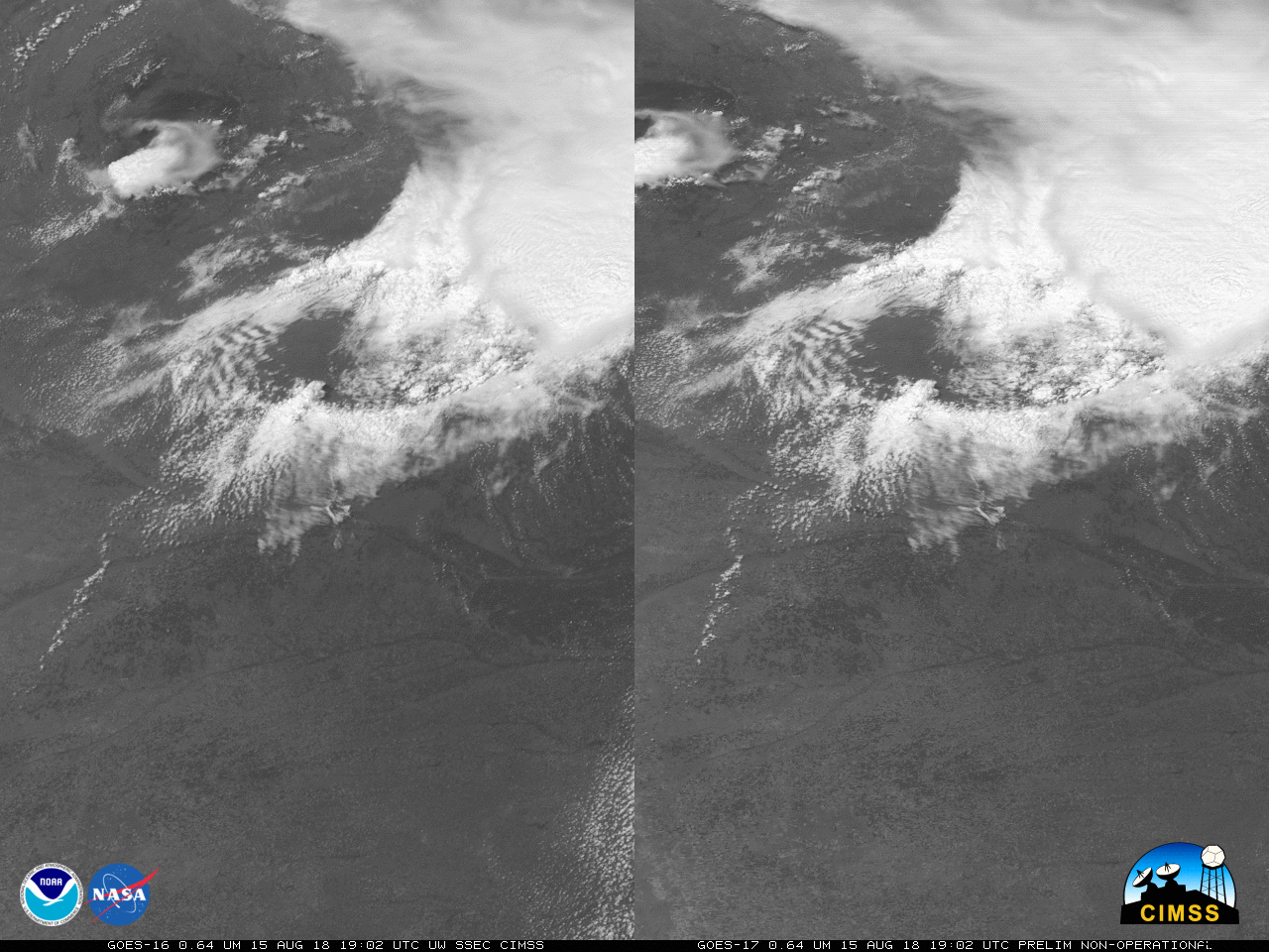
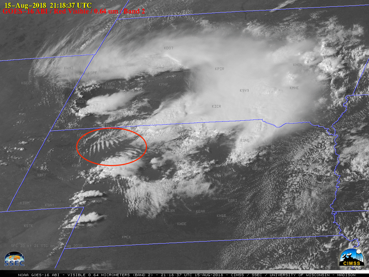
1-minute Mesoscale Domain Sector GOES-16 (GOES-East) “Red” Visible (0.64 µm) images (above) showed the development of thunderstorms which produced large hail and damaging winds across parts of southwestern South Dakota and western/central Nebraska (SPC Storm Reports) on 15 August 2018. The dominant storm in Nebraska exhibited a well-defined Above Anvil Cirrus Plume (AACP), which is often an... Read More

GOES-16 “Red” Visible (0.64 µm) images, with time-matched (+/- 3 minutes) SPC Storm Reports plotted in red [click to play MP4 animation]
1-minute
Mesoscale Domain Sector GOES-16
(GOES-East) “Red” Visible (
0.64 µm) images
(above) showed the development of thunderstorms which produced large hail and damaging winds across parts of southwestern South Dakota and western/central Nebraska (
SPC Storm Reports) on
15 August 2018. The dominant storm in Nebraska exhibited a well-defined Above Anvil Cirrus Plume (AACP), which is often an indicator of a storm producing severe weather such as tornadoes, large hail or damaging wind (
reference). Also note the slow-moving parallel bands of boundary layer wave clouds or “
billow clouds” in northwestern Nebraska — this is a signature of warmer air flowing along the top of a low-level temperature inversion (caused by a pool of cold outflow from earlier thunderstorms). A stereoscopic view of this convection (using GOES-16 and GOES-17 visible images) can be seen
here.
The corresponding GOES-16 Mid-level Water Vapor (6.9 µm) images (below) better revealed the broad circulation of a middle-tropospheric low that was centered over South Dakota (500 hPa analysis).
![GOES-16 Mid-level Water Vapor (6.9 µm) images, with SPC storm reports plotted in red [click to play MP4 animation]](https://cimss.ssec.wisc.edu/satellite-blog/wp-content/uploads/sites/5/2018/08/G16_WV_SD_NE_SVR_15AUG2018_960x1280_B9_2018227_223437_0001PANEL_00155.GIF)
GOES-16 Mid-level Water Vapor (6.9 µm) images, with time-matched (+/- 3 minutes) SPC Storm Reports plotted in red [click to play MP4 animation]
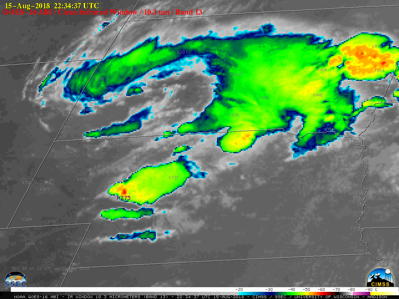
![GOES-16 "Clean" Infrared Window (10.4 µm) images, with SPC storm reports plotted in purple [click to play MP4 animation]](https://cimss.ssec.wisc.edu/satellite-blog/wp-content/uploads/sites/5/2018/08/G16_IR_SD_NE_SVR_15AUG2018_960x1280_B13_2018227_223437_0001PANEL_00155.GIF)
GOES-16 “Clean” Infrared Window (10.3 µm) images, with time-matched (+/- 3 minutes) SPC Storm Reports plotted in purple [click to play MP4 animation]
GOES-16 “Clean” Infrared Window (
10.3 µm) images
(above) showed that the coldest cloud-top infrared brightness temperatures associated with thunderstorm overshooting tops were around -60ºC
(darker red enhancement) — slightly warmer than that of the tropopause on rawinsonde data from North Platte, Nebraska
(below).
![Plots of rawinsonde data from North Platte, Nebraska at 12 UTC on 15 August and 16 August [click to enlarge]](https://cimss.ssec.wisc.edu/satellite-blog/wp-content/uploads/sites/5/2018/08/180815_180816_KLBF_RAOBS.GIF)
Plots of rawinsonde data from North Platte, Nebraska at 12 UTC on 15 August and 16 August [click to enlarge]
Regarding the AACP feature, in this case the plume was
colder than the adjacent underlying thunderstorm anvil, as seen in a toggle between GOES-16 Visible and Infrared images at 0005 UTC — when the storm produced a wind gust of 70 mph at the surface
(below). The temperature profile and lapse rate of the upper tropospheric/lower stratospheric air directly above the thunderstorm overshooting top will have an influence on whether an AACP is warmer or colder than the underlying thunderstorm anvil surface.
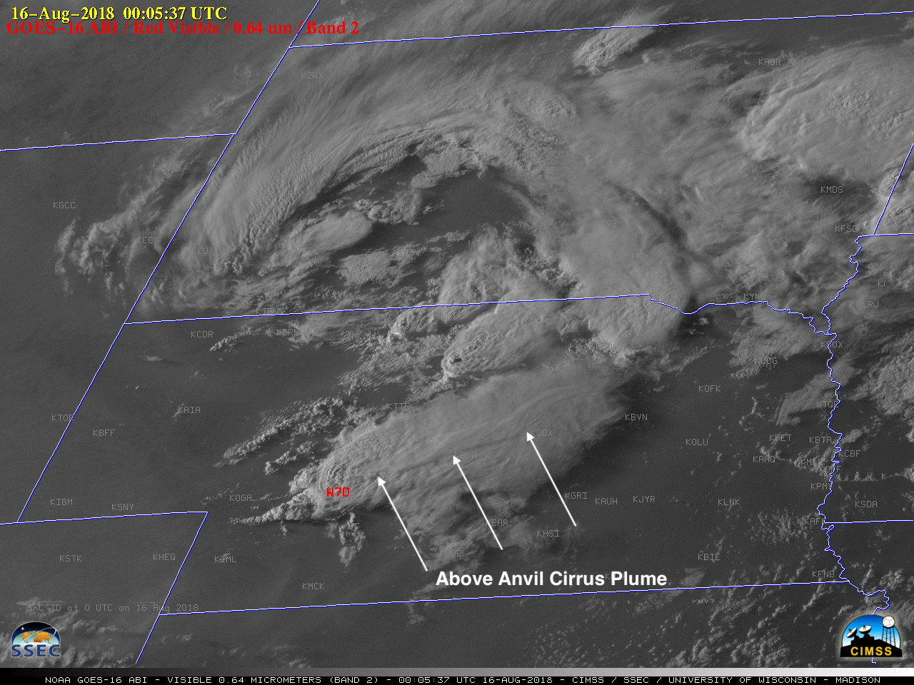
GOES-16 “Red” Visible (0.64 µm) and “Clean” Infrared Window (10.3 µm) images at 0005 UTC [click to enlarge]
Finally, when trying to correlate the location of storm-top satellite image features with reports of hail/wind/tornadoes at the surface, it is important to factor in the effect of
parallax. The GOES-16 satellite (positioned over the Equator at 75.2º W longitude) viewing angle for the North Platte area is 54 degrees — which has the effect of shifting the apparent location of storm-top features to the
northwest of their true location over the Earth’s surface. The pair of image toggles shown below demonstrate how the “parallax-corrected” (northwest-shifted) location of the hail or wind reports more closely aligns with the cold overshooting top
(orange to red enhancement) associated with the strongest storm updraft at that time.
GOES-16 “Clean” Infrared Window (10.3 µm) image at 2234 UTC, with the actual and “parallax-corrected” locations of a 2.75-inch hail report [click to enlarge]
![GOES-16 "Clean" Infrared Window (10.3 µm) image at 0005 UTC, with the actual and parallax-corrected locations of a 70 mph wind gust [click to enlarge]](https://cimss.ssec.wisc.edu/satellite-blog/wp-content/uploads/sites/5/2018/08/180816_0005utc_goes16_infrared_spc_storm_report_parallax_NE_anim.gif)
GOES-16 “Clean” Infrared Window (10.3 µm) image at 0005 UTC, with the actual and “parallax-corrected” locations of a 70 mph wind gust report [click to enlarge]
View only this post
Read Less


![GOES-15, GOES-14, GOES-17 and GOES-16 Shortwave Infrared (3.9 µm) images [click to play MP4 animation]](https://cimss.ssec.wisc.edu/satellite-blog/wp-content/uploads/sites/5/2018/08/G15_G14_G17_G16_SWIR_CARR_FIRE_CA_11AUG2017_960x320_B2277_2018223_191500_0004PANELS_00254.GIF)
![Landsat-8 False Color and Thermal Infrared (10.9 µm) images [click to enlarge]](https://cimss.ssec.wisc.edu/satellite-blog/wp-content/uploads/sites/5/2018/08/180811_1851utc_landsat8_falsecolor_thermalInfrared_Carr_Fire_anim.gif)
