Lake/river effect clouds in North Dakota
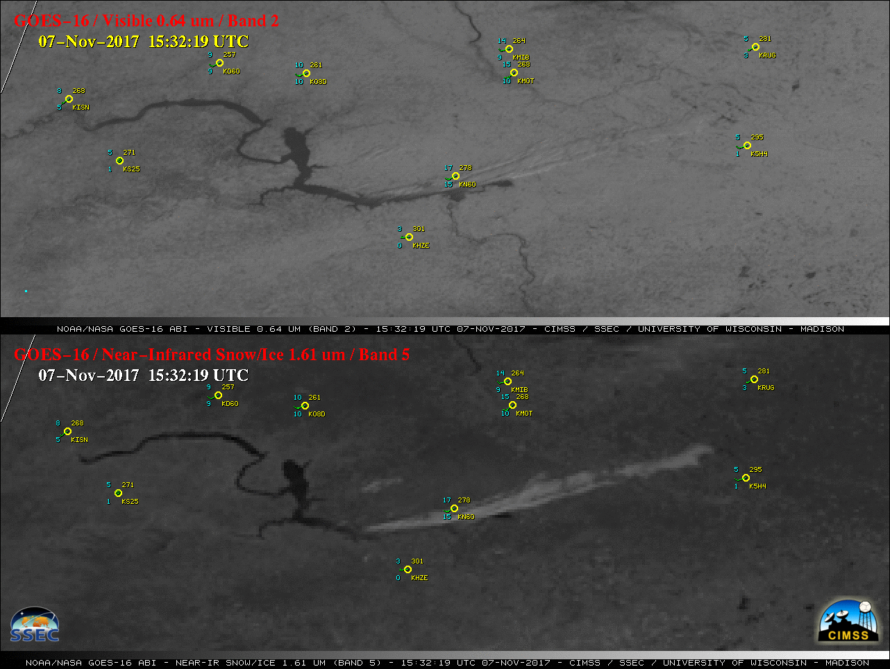
GOES-16 “Red” Visible (0.64 µm, top) and Near-Infrared “Snow/Ice” (1.61 µm, bottom) images, with plots of hourly surface reports [click to play MP4 animation]
As cold arctic air continued to move eastward across North Dakota on 07 November 2017, GOES-16 “Red” Visible (0.64 µm) and Near-Infrared “Snow/Ice” (1.61 µm) images (above) showed “lake effect” cloud plumes streaming east-northeastward from Lake Sakakawea (and also from Missouri River). The Snow/Ice images were the most useful for discriminating between supercooled water droplet cloud plumes (brighter shades of white) and the surrounding snow-covered land surfaces (darker shades of gray).
During the preceding nighttime hours, Suomi NPP VIIRS and Aqua MODIS Infrared Brightness Temperature Difference images (below) — the legacy “fog/stratus product” — revealed that the orientation of the Lake Sakakawea cloud plume changed as surface winds switched from northwesterly to westerly.
![Infrared Brightness Temperature Difference images from Suomi NPP VIIRS (11.45 µm = 3.74 µm) and Aqua MODIS (11.0 µm - 3.7 µm) [click to enlarge]](https://cimss.ssec.wisc.edu/satellite-blog/wp-content/uploads/sites/5/2017/11/171107_viirs_modis_ir_btd_ND_anim.gif)
Infrared Brightness Temperature Difference images from Suomi NPP VIIRS (11.45 µm = 3.74 µm) and Aqua MODIS (11.0 µm – 3.7 µm) [click to enlarge]
![Aqua MODIS Sea Surface Temperature product [click to enlarge]](https://cimss.ssec.wisc.edu/satellite-blog/wp-content/uploads/sites/5/2017/11/MODIS_SST_20171107_1930.png)
Aqua MODIS Sea Surface Temperature product [click to enlarge]
![GOES-16 Day Snow-Fog RGB images [click to animate]](https://cimss.ssec.wisc.edu/satellite-blog/wp-content/uploads/sites/5/2017/11/171107_goes16_DaySnowFog_RGB_ND_anim.gif)
GOES-16 Day Snow-Fog RGB images [click to animate]
![GOES-16 Day Snow-Fog RGB images [click to animate]](https://cimss.ssec.wisc.edu/satellite-blog/wp-content/uploads/sites/5/2017/11/171107_goes16_DaySnowFog_RGB_ND_power_plant_plumes_anim.gif)
GOES-16 Day Snow-Fog RGB images [click to animate]
GOES-16 “Red” Visible images [click to animate]