This website works best with a newer web browser such as Chrome, Firefox, Safari or Microsoft Edge. Internet Explorer is not supported by this website.

Winter storm affecting the Mid-Atlantic states

GOES-16 (GOES-East) Air Mass RGB images (above) showed the signature of a Potential Vorticity (PV) Anomaly — denoted by shades of red to pink within the comma head portion of the storm — which likely aided in enhancing precipitation rates within a midlatitde cyclone (surface analyses) as it moved across the region on... Read More

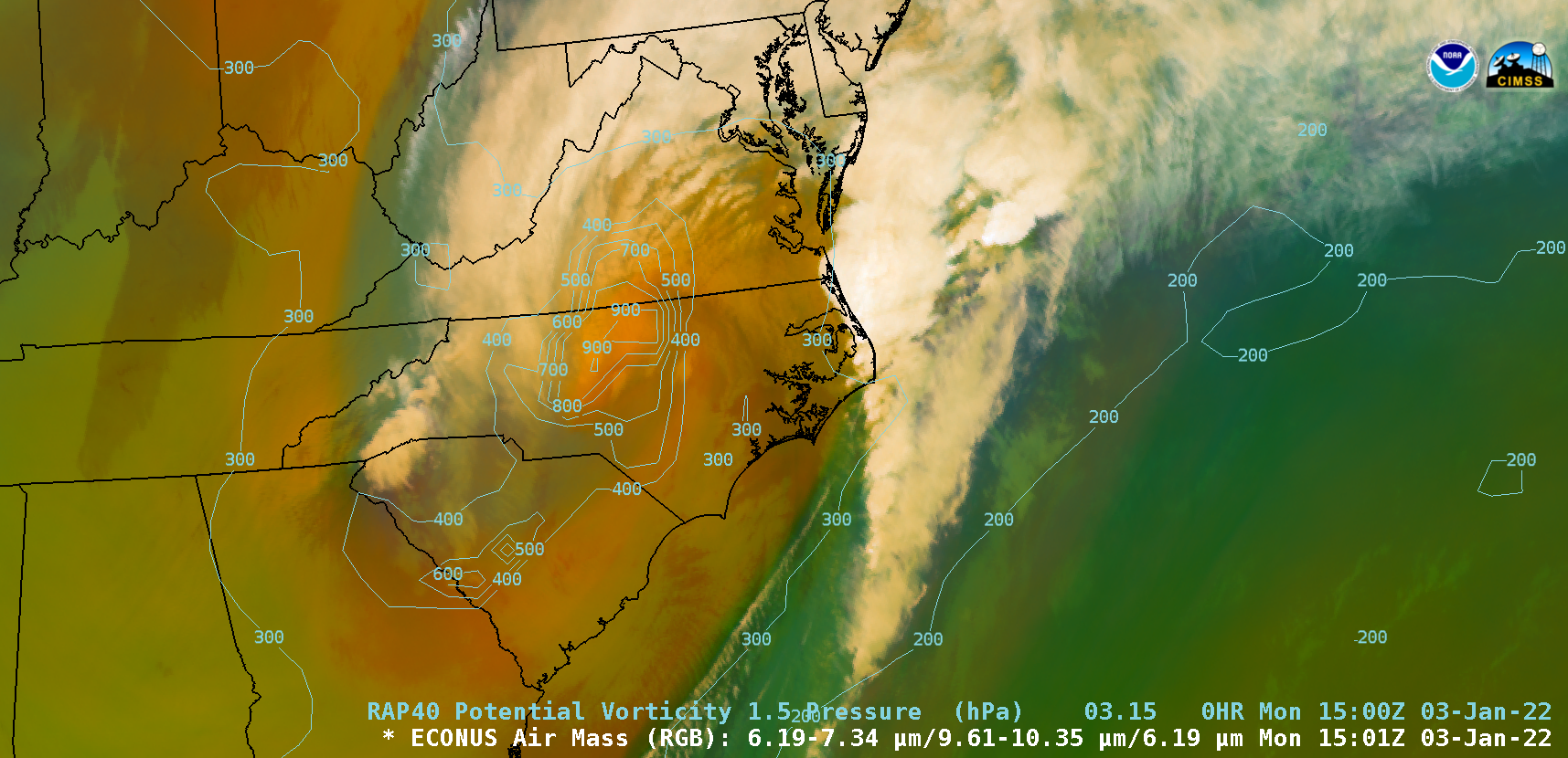
GOES-16 Air Mass RGB images, with and without contours of RAP40 model PV1.5 pressure [click to play animated GIF | MP4]

GOES-16 (GOES-East) Air Mass RGB images (above) showed the signature of a Potential Vorticity (PV) Anomaly — denoted by shades of red to pink within the comma head portion of the storm — which likely aided in enhancing precipitation rates within a midlatitde cyclone (surface analyses) as it moved across the region on 03 January 2022. RAP40 model contours of PV1.5 pressure indicated that the “dynamic tropopause” descended as low as the 900 hPa pressure level.

GOES-16 “Red” Visible (0.64 µm) images with plots of hourly surface weather type (below) showed the distribution of precipitation from 1400-2120 UTC (9:00 am – 4:20 pm EDT). Overlapping 1-minute Mesoscale Domain Sectors provided imagery at 30-second intervals during this time period. Note the development of convective banding where heavier precipitation was being reported — this storm was responsible for producing flooding rainfall and significant snowfall.

GOES-16 “Red” Visible (0.64 µm) images, with hourly surface weather type plotted in yellow [click to play animated GIF | MP4]

 ===== 04 January Update =====

GOES-16 “Red” Visible (0.64 µm) and Day Snow-Fog RGB images [click to play animated GIF | MP4]

On the following day, GOES-16 Visible and Day Snow-Fog RGB images (above) displayed the areal coverage of resulting swath of snow cover (shades of red in the RGB imagery), which stretched from northern Alabama and Georgia to southern New Jersey. A few patches of low stratiform clouds (shades of white in the RGB images) persisted in parts of the southern Appalachians during the day.

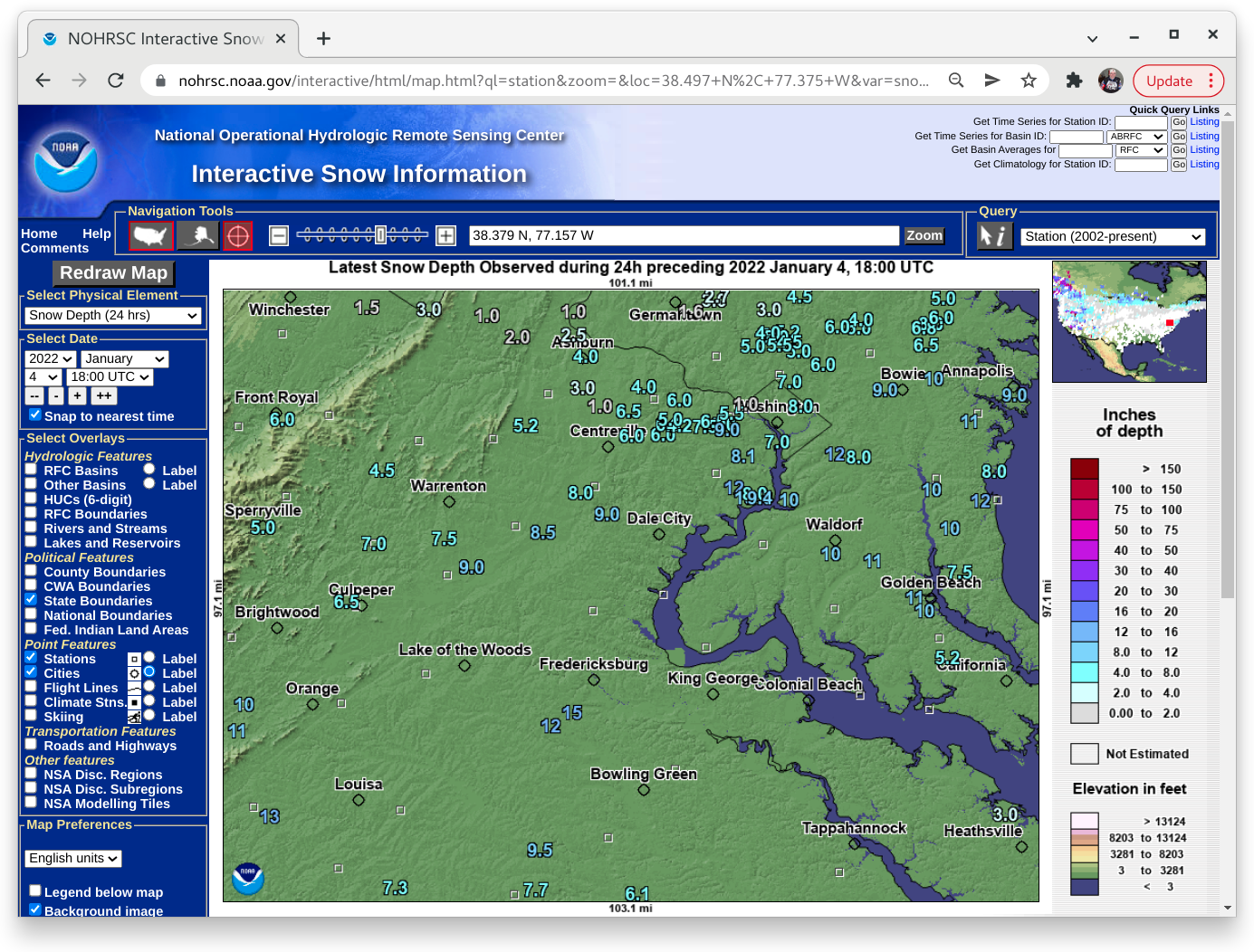
A closer look at GOES-16 Visible and Day Snow-Fog RGB images (below) is centered on Virginia — and showed the portion of Interstate 95 in northern Virginia (between Fredricksburg KEZR and Washington KDCA) where hundreds of vehicles became stranded for as long as 24 hours. Snow depths were generally in the 8-12 inch range across that area.  

GOES-16 “Red” Visible (0.64 µm) and Day Snow-Fog RGB images [click to play animated GIF | MP4]

View only this post Read Less

Tehuano wind event

A sequence of ASCAT winds (source) from overpasses of Metop-B and Metop-C at 0314, 0407, 1548 and 1607 UTC on 03 January 2022 (above) showed the early emergence of Tehuano gap winds into the Gulf of Tehuantepec, followed by their spread south-southwestward across the Pacific Ocean.GOES-16 Shortwave Infrared (3.9 µm)... Read More

ASCAT winds from Metop-B and Metop-C [click to enlarge]

A sequence of ASCAT winds (source) from overpasses of Metop-B and Metop-C at 0314, 0407, 1548 and 1607 UTC on 03 January 2022 (above) showed the early emergence of Tehuano gap winds into the Gulf of Tehuantepec, followed by their spread south-southwestward across the Pacific Ocean.

GOES-16 Shortwave Infrared (3.9 µm) images (below) revealed a cooling trend within the Gulf of Tehuantepec during the 0500-2100 UTC period — with water surface 3.9 µm brightness temperatures dropping from around 24ºC (orange enhancement) to 18ºC and below (yellow enhancement) — as the strong gap wind flow induced upwelling of colder water.

GOES-16 Shortwave Infrared (3.9 µm) images [click to play animated GIF | MP4]

The offshore transport of airborne dust was evident in GOES-17 True Color RGB images created using Geo2Grid (below).

GOES-17 True Color RGB images [click to play animated GIF | MP4]

View only this post Read Less

There GOES 2021

Daily Full Disk imageryBy animating daily NOAA GOES-16 or GOES-17 ABI Full Disk visible imagery, the year are 2021 can be shown quickly in review. The GOES-16 loops show an 17 UTC image each day of 2021, while GOES-17 shows an image from 21 UTC. The images are Rayleigh-corrected composites.... Read More

Daily Full Disk imagery

By animating daily NOAA GOES-16 or GOES-17 ABI Full Disk visible imagery, the year are 2021 can be shown quickly in review. The GOES-16 loops show an 17 UTC image each day of 2021, while GOES-17 shows an image from 21 UTC. The images are Rayleigh-corrected composites. The GOES-16 loop is similar to a loop that includes the Solstice-to-Solstice dates.

One GOES-16 ABI image for each day of 2021: http://cimss.ssec.wisc.edu/goes/loops/17z_2021_GOES.html.

A link to a page with one GOES-16 ABI image for each day of 2021: http://cimss.ssec.wisc.edu/goes/loops/17z_2021_GOES.html Other versions as an mp4, from the ABI on GOES-16: small, medium. It should be noted that all these images are drastically sub-sampled from the higher spatial resolution imagery.

A similar year-long animation, from GOES-17 at 21 UTC daily. This time was chosen for a maximum illumination of the full disk.

Click on the above image for a link to a page with one GOES-17 ABI image for each day of 2021.

Interactive web page for GOES-17 ABI images at 21 UTC. Other mp4 versions, as mp4, from the ABI on GOES-17: small or medium.

A GOES-16 years long loop at 11 UTC each day.

An interactive web page, show GOES-16 11 UTC imagery. Note how the terminator changes over time. (The solstice to solstice “supercool animation” part was written up by Discover Magazine.)

Mollweide Projection (combined GOES-17 and GOES-16)

Year-long, GOES-16 and GOES-17 combined images, in a Mollweide projection.

2021: 12 UTC only, combined GOES-17 and GOES-16 ABI longwave infrared (IR) window.

A similar loop, but hourly (large file: ~200 MB). More near realtime combined GOES-16/17 images.

H/T

These images were made with geo2grid s/w or McIDAS-X, with NOAA GOES data via the UW-Madison, SSEC. Many more GOES-16 and GOES-17 loops on the CIMSS Satellite Blog or this link of links.

View only this post Read Less

Marshall Fire near Boulder, Colorado

GOES-16 Fire Temperature RGB, Shortwave Infrared (3.9 µm) Fire Power and Fire Temperature derived products (above) showed rapid expansion of the Marshall Fire’s thermal signature in Boulder County, Colorado on 30 December 2021. The earliest unambiguous fire signature appeared on the 1841 UTC image (11:41 am MST); the maximum 3.9 µm infrared brightness temperature was 110.96ºC (at 2021... Read More

GOES-16 Fire Temperature RGB (top left), Shortwave Infrared (3.9 µm, top right), Fire Power (bottom left) and Fire Temperature (bottom right), [click to play animated GIF | MP4]

GOES-16 Fire Temperature RGB, Shortwave Infrared (3.9 µm) Fire Power and Fire Temperature derived products (above) showed rapid expansion of the Marshall Fire’s thermal signature in Boulder County, Colorado on 30 December 2021. The earliest unambiguous fire signature appeared on the 1841 UTC image (11:41 am MST); the maximum 3.9 µm infrared brightness temperature was 110.96ºC (at 2021 UTC), the peak Fire Power was 1848.94 MW (at 2031 UTC) and the peak Fire Temperature was 1632.94 K (at 2031 UTC). The fire burned over 6000 acres in less than 24 hours, and destroyed or damaged over 1000 homes and businesses (making it the most destructive wildfire on record for the state of Colorado).

A comparison of Shortwave Infrared images from GOES-17 (GOES-West) and GOES-16 (GOES-East) is shown below. As was the case above, the earliest unambiguous fire thermal signature appeared on the 1841 UTC images from both satellites. Beginning at 2100 UTC, a GOES-17 Mesoscale Domain Sector was positioned over the region to monitor the ongoing fire, which provided images at 1-minute intervals.

Shortwave Infrared (3.9 µm) images from GOES-17 (left) and GOES-16 (right) [click to play animated GIF | MP4]

GOES-17 and GOES-16 Low-level (7.3 µm), Mid-level (6.9 µm) and Upper-level (6.2 µm) Water Vapor images (below) revealed the rapid development of a band of pronounced warming/drying — indicative of strong mountain wave subsidence — over the Front Range (centered near the Boulder KBOU area), along with additional mountain waves extending to the east. The band of strong mountain wave subsidence helped to transfer the momentum of strong westerly winds aloft (Boulder rawinsondes) downward to the surface; the rapid spread of the fire was driven by very strong surface winds, gusting to speeds over 100 mph.

GOES-17 (left) and GOES-16 (right) Upper-level (6.2 µm, top), Mid-level (6.9 µm, center) and Low-level (7.3 µm, bottom) Water Vapor images [click to play animation | MP4]

GOES-16 True Color RGB images created using Geo2Grid (below) highlighted the smoke plume, which drifted as far eastward as Nebraska and Kansas by sunset. Note the development of Kelvin-Helmholtz waves (particularly along the northern edge) as lee-side mountain waves distorted the smoke plume. Smoke briefly reduced the surface visibility to 1.5 miles at Denver International Airport — and farther to the east, the visibility dropped to 7 miles at Fort Morgan. Several other narrow plumes of blowing dust could be seen moving eastward across the eastern Colorado plains (which was experiencing severe to extreme drought). 

GOES-16 True Color RGB images [click to play animated GIF | MP4]

1-minute GOES-17 True Color RGB images are shown below.

GOES-17 True Color RGB images [click to play animated GIF | MP4]

VIIRS Fire RGB images from Suomi-NPP and NOAA-20 as viewed using RealEarth (below) showed the coverage of the Marshall Fire (cluster of red pixels) at 3 time periods.

VIIRS Fire RGB images from Suomi-NPP and NOAA-20 [click to enlarge]

===== 31 December Update =====

VIIRS Shortwave Infrared (3.74 µm) from Suomi-NPP [click to enlarge]

During the subsequent nighttime hours, a VIIRS Shortwave Infrared (3.74 µm) from Suomi-NPP (above) displayed thermal anomalies associated with active fire pockets that continued to burn at 0925 UTC or 2:25 am MST. 

View only this post Read Less