Explosive events from the Kilauea Volcano (located on the Big Island of Hawai’i) began to occur in mid-March of 2008 — these were the first explosive events from that particular volcano since 1927. Activity from Kilauea then continued for several weeks; GOES-11 (GOES-West) 0.63 µm visible... Read More
")
Explosive events from the Kilauea Volcano (located on the Big Island of Hawai’i) began to occur in mid-March of 2008 — these were the first explosive events from that particular volcano since 1927. Activity from Kilauea then continued for several weeks; GOES-11 (GOES-West) 0.63 µm visible imagery from 07 April 2008 (above) showed the hazy signature of a long volcanic plume (composed primarily of steam, but possibly containing small amounts of ash) streaming southwestward from Hawai’i. With the typical northeasterly trade winds that often persist over that region, this was the common scenario seen on many days during late March into early April.
However, the northeasterly trade wind flow regime was interrupted by a surface trough of low pressure on 08 April 2008, and southerly to southeasterly winds began to advect the Kilauea plume to the north and northwest during the day (photo). The volcanic plume at that time contained significantly elevated amounts of sulfur dioxide (SO2), which forced the closure of Hawai’i Volcanoes National Park on 08 April. GOES-11 visible imagery (below) revealed two separate plumes, emanating from the Halema`uma`u and the Pu`u `O`o vents of the Kilauea volcano.
")
The volcanic SO2 plume on 08 April could be tracked using a GOES-11 sounder brightness temperature difference product (subtracting the 13.4 µm band 5 temperature from the 7.4 µm band 10 temperature) — a small “bubble” of elevated SO2 concentration (brightness temperature difference values of 0º to +5º K, yellow to orange colors) was seen to move slowly northwestward from the Big Island of Hawai’i toward the smaller islands of Maui/Kahoolawe/Lanai/Molokai (below). Unfortunately, GOES-11 sounder data over the Hawai’i region is only available 7 times a day (not once per hour, as it is over the continental US), so the motion of the SO2 feature was more difficult to follow compared to using the more frequent 15-minute visible imagery from the GOES-11 imager.

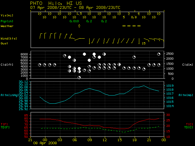
The surface visibility at Lahaina / West Maui (station identifier PHJH, below) decreased from 15 miles to 7 miles (with haze reported) as southerly winds blew the volcanic plume and SO2 cloud over the island of Maui on 08 April. On the Big Island of Hawai’i, volcanic fog (sometimes referred to as “vog”) reduced visibility to less than 1 mile at Hilo.

The 7.4 µm band 10 of the GOES sounder is primarily a “water vapor absorption” band, but this particular sounder channel is also sensitive to high SO2 loadings in the atmosphere (as shown by the figure shown below, taken from Ackerman, S. A., A. J. Schreiner, T. J. Schmit, H. M. Woolf, J. Li1, and M. Pavolonis, 2008: Using the GOES Sounder to Monitor Upper-level SO2 from Volcanic Eruptions, submitted to Journal of Geophysical Research). The plot also shows that high SO2 loading could be detected using a channel located within the 8.4-9.0 µm band.

The Advanced Baseline Imager (ABI) on the future GOES-R satellite will have a similar 7.3 µm channel (at a 2 km spatial resolution, compared to the 10 km spatial resolution on the current GOES sounder), and with ABI imagery available at more frequent time intervals (images every 5 minutes over the full disk), the detection of these types of volcanic SO2 plumes will be significantly improved in the GOES-R era.
Terra MODIS images at 20:55 UTC on 08 April (below; courtesy of Mat Gunshor, CIMSS) demonstrate the utility of using the 11.0 µm – 8.5 µm brightness temperature difference product to help discriminate between the SO2 plume (darker blue enhancement on the difference product image, moving north from the Big Island of Hawai’i) and the larger steam plume (evident as the hazy area on the visible image, moving westward and northwestward from the island).
")
View only this post
Read Less
 product")
")

")


")
")
")
")
")
