Hurricanes Charley (2004) and Ian (2022)
Both Hurricanes Charley (2004) and Ian (2022) were extremely strong storms to strike the west coast of Florida. Both Charley and Ian were upper Category 4 storms, as a measure of their wind speeds. Of course wind speed is only one of the critical impacts of a hurricane. For more information on Hurricane Ian, see other UW CIMSS Satellite Blog posts such as when the hurricane made a landfall in Florida on September 28th and again in South Carolina on the 30th (by Scott Bachmeier, UW/CIMSS), the CIMSS Tropical Cyclones page, or a blog post by Bill Line, NOAA / NEDSIS.
GOES-12 versus GOES-16 (ABI)
The quality of the monitoring of storms between GOES-12 and GOES-16 were orders of magnitude improved. For example, GOES-12 provided imagery with intervals of between 7 and 30 minutes, while the Advanced Baseline Imager (ABI) provided images every 30 seconds via the meso-scale sector. The spatial resolutions of the longwave infrared window improved from approximately 4 to 2 km, while the visible band improved from 1 to 0.5 km. In addition, there were calibration and navigation improvements.
Longwave Infrared band
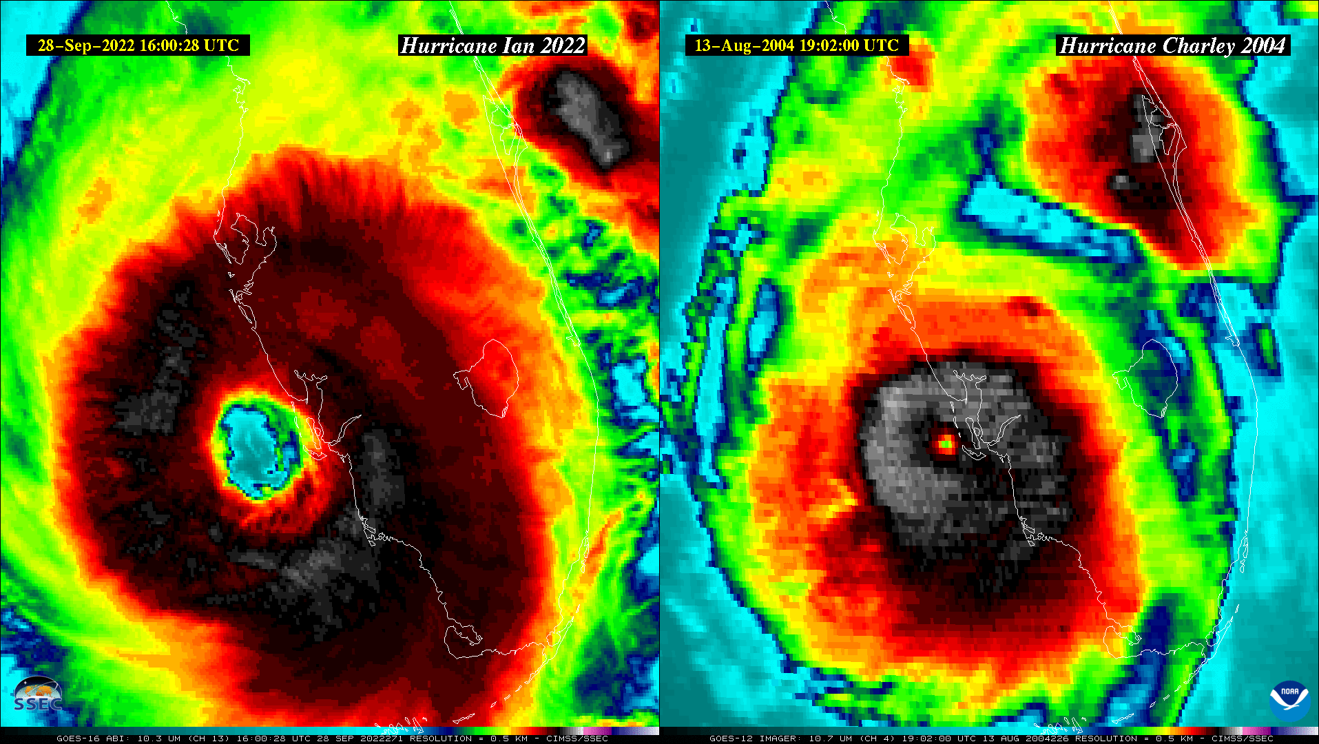
This longwave infrared window (heat of the emitting surface) loop has the imagery remapped to the same projection. The Ian ABI loop runs from 13:00:28 to 17:59:55 UTC on September 29, 2022, while the GOES-12 Imager Charley loop covers from 15:15 to 19:55 UTC on August 13, 2004. Note the improved temporal and spatial resolutions.
IR window loop as an animated gif and mp4. There are also version with a 30-sec duration (mp4). Both satellite images have been remapped to the same projection.
Drag the center line left or right to compare the two storms. Note the very different eye sizes. A toggle loop.

Visible band
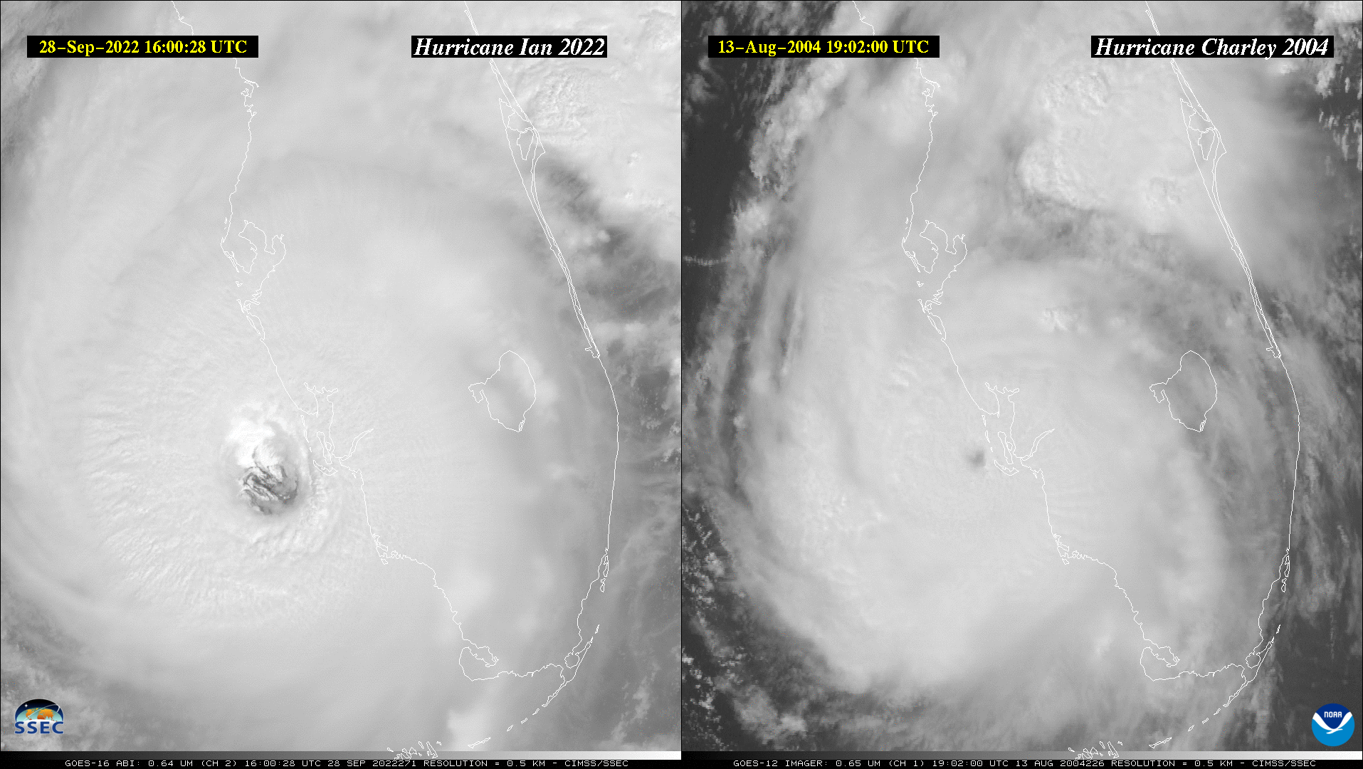
This visible (reflected light) loop has the imagery remapped to the same projection. The Ian ABI loop runs from 13:00:28 to 17:59:55 UTC on September 29, 2022, while the GOES-12 Imager Charley loop covers from 15:15 to 19:55 UTC on August 13, 2004. Note the improved temporal and spatial resolutions.
Visible loop as an animated gif and mp4. There are also version with a 30-sec duration (mp4). Note that the landfall occurred about 3 hours later in the day for Hurricane Charley, compared to Ian. Both satellite images have been remapped to the same projection.
Drag the center line left or right to compare the two storms. Note the very different eye sizes. A toggle loop.

Several Social Media Posts Comparing Ian to Charley
There were several social media posts comparing these two storms, both the satellite and radar perspectives.
Ian Collage
Several views of Hurricane Ian just before making landfall. This includes visible / near-infrared bands (first row), infrared bands (second row) and RGB composites (last 3 rows). These images were made with UW/SSEC geo2grid python software with a number of other UNIX scripts. A larger version.

H/T
Thanks to Scott Lindstrom, SSEC for the idea for these comparison loops, and Jim Nelson, CIMSS for the loops. The McIDAS-X software was used with NOAA‘s GOES data via the UW/SSEC Data Services. More on GOES-R series ABI imagery and resources.

