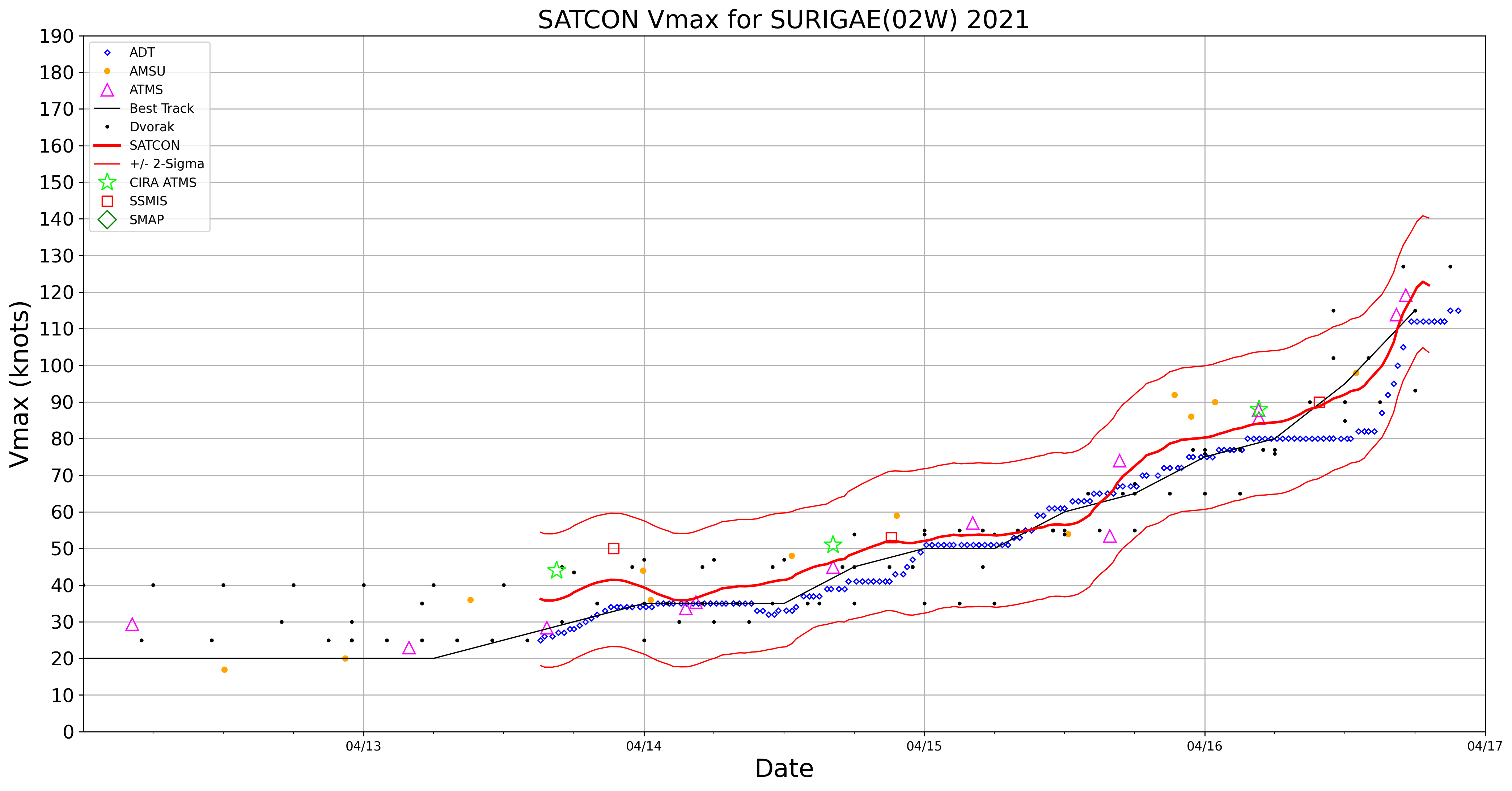
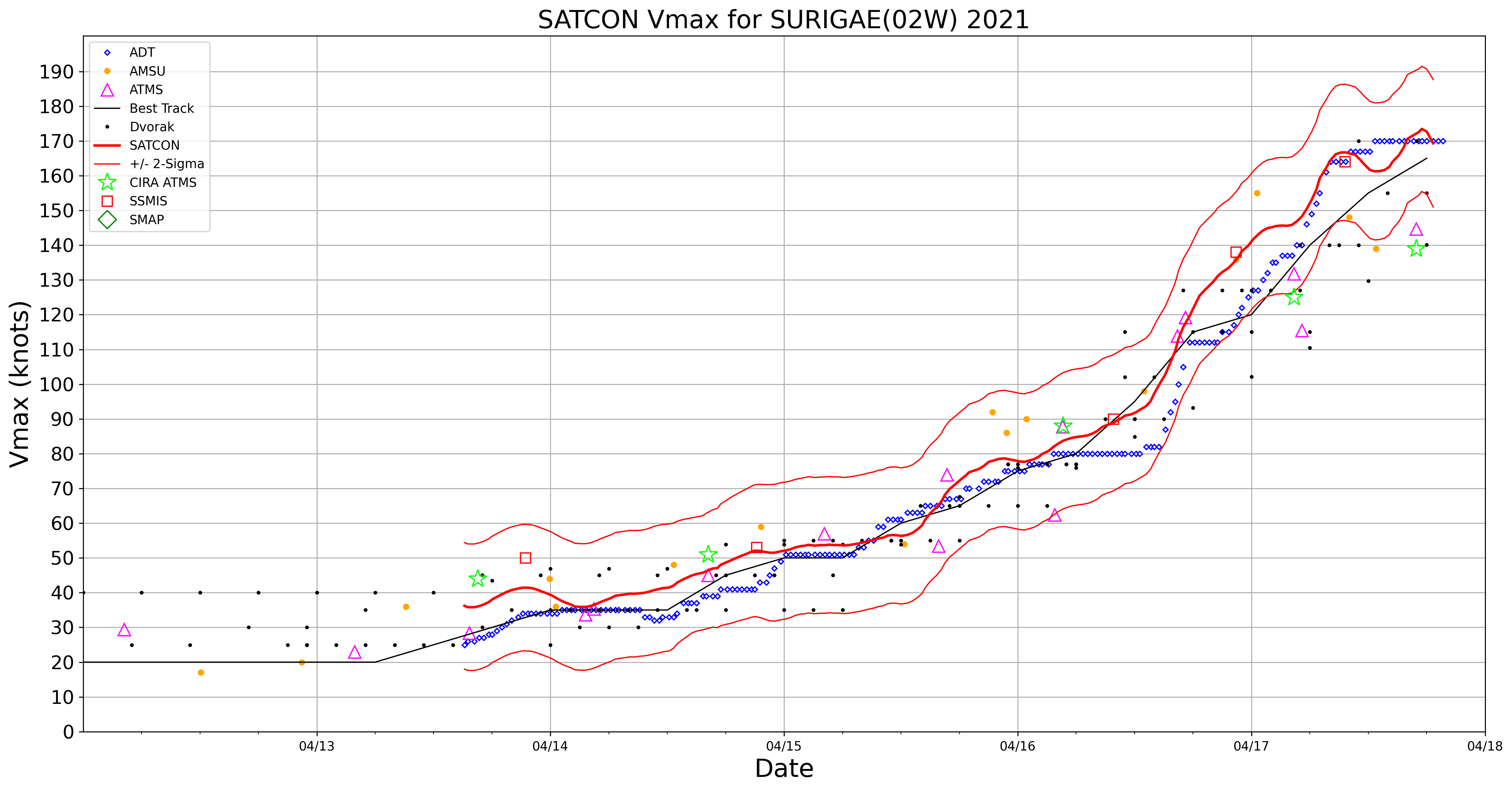
Rapid intensification of Super Typhoon Surigae
![JMA Himawari-8 Infrared Window (10.4 µm) images [click to play animation]](https://cimss.ssec.wisc.edu/satellite-blog/images/2021/04/210416_himawari8_infrared_Typhoon_Surigae_anim.gif)
JMA Himawari-8 Infrared Window (10.4 µm) images [click to play animation]
A DMSP-16 SSMIS Microwave (85 GHz) image from the CIMSS Tropical Cyclones site (below) displayed a well-defined eye, with distinct spiral bands feeding into the eyewall.
![DMSP-16 SSMIS Microwave (85 GHz) image at 1944 UTC [click to enlarge]](https://cimss.ssec.wisc.edu/satellite-blog/images/2021/04/210416_1944utc_dmsp16_ssmi_microwave_Surigae.gif)
DMSP-16 SSMIS Microwave (85 GHz) image at 1944 UTC [click to enlarge]
![JMA Himawari-8 "Red" Visible (0.64 µm) images [click to play animation]](https://cimss.ssec.wisc.edu/satellite-blog/images/2021/04/210416_himawari8_visible_Typhoon_Surigae_anim.gif)
JMA Himawari-8 “Red” Visible (0.64 µm) images [click to play animation]
===== 17 April Update =====
![JMA Himawari-8 Infrared Window (10.4 µm) images [click to play animation | MP4]](https://cimss.ssec.wisc.edu/satellite-blog/images/2021/04/210417_himawari8_infrared_Typhoon_Surigae_anim.gif)
JMA Himawari-8 Infrared Window (10.4 µm) images [click to play animation | MP4]
Year and date of all 165kt tropical cyclones on record around the world. pic.twitter.com/JLUwjceapf
— Sam Lillo (@splillo) April 17, 2021
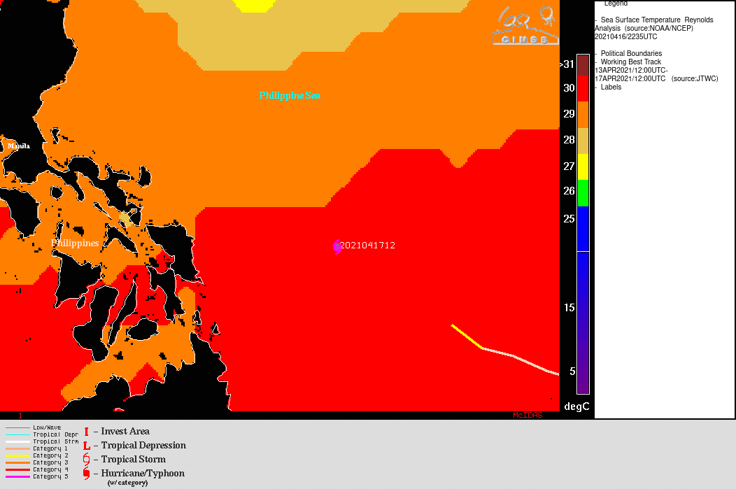
An animation of Himawari-8 Infrared images with an overlay of deep-layer wind shear (below) indicated that Surigae was moving through a region of low to moderate wind shear; the storm was also moving across very warm water (SST + OHC).
![Himawari-8 Infrared images, with contours of deep-layer wind shear at 18 UTC [click to enlarge]](https://cimss.ssec.wisc.edu/satellite-blog/images/2021/04/210417_himawari8_infrared_shear_Surigae_2_anim.gif)
Himawari-8 Infrared images, with contours of deep-layer wind shear at 18 UTC [click to enlarge]
![Suomi NPP VIIRS Day/Night Band (0.7 µm) image [click to enlarge]](https://cimss.ssec.wisc.edu/satellite-blog/images/2021/04/h8_dnb_large-20210417_165946.png)
Suomi NPP VIIRS Day/Night Band (0.7 µm) image [click to enlarge]
![Himawari-8 Infrared Window (10.4 µm) and Suomi NPP VIIRS Day/Night Band (0.7 µm) images [click to enlarge]](https://cimss.ssec.wisc.edu/satellite-blog/images/2021/04/210417_1654utc_himawari8_infrared_suomiNPP_dayNightBand_Super_Typhoon_Surigae_anim.gif)
Himawari-8 Infrared Window (10.4 µm) and Suomi NPP VIIRS Day/Night Band (0.7 µm) images [click to enlarge]