Category 4 Hurricane Laura makes landfall in Louisiana
![GOES-16 “Red” Visible (0.64 µm) and “Clean” Infrared Window (10.35 µm) images (with and without an overlay of GLM Flash Extent Density) [click to play animation | MP4]](https://cimss.ssec.wisc.edu/satellite-blog/images/2020/08/200826_goes16_visible_infrared_glmFlashExtentDensity_Hurricane_Laura_anim.gif)
GOES-16 “Red” Visible (0.64 µm) and “Clean” Infrared Window (10.35 µm) images (with and without an overlay of GLM Flash Extent Density) [click to play animation | MP4]
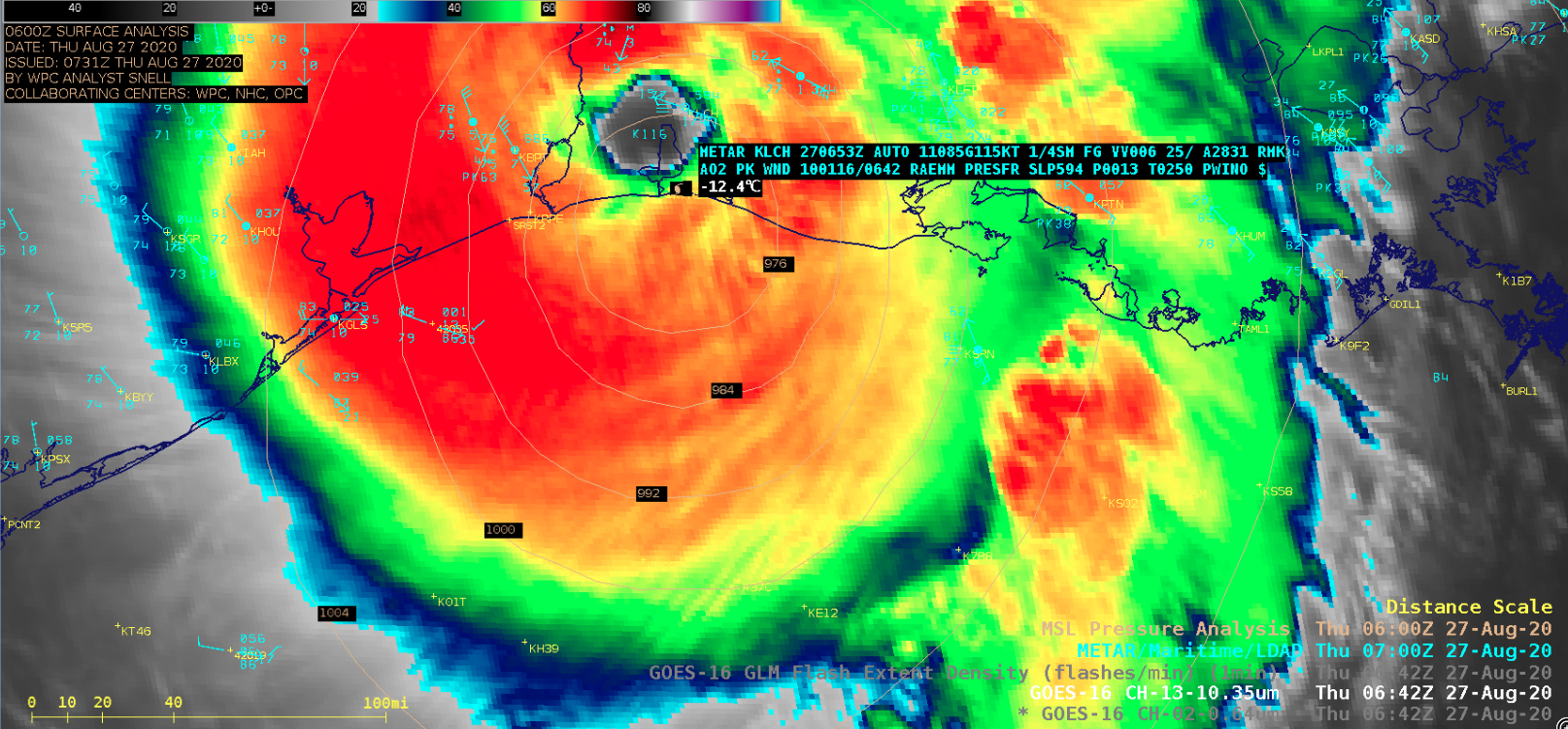
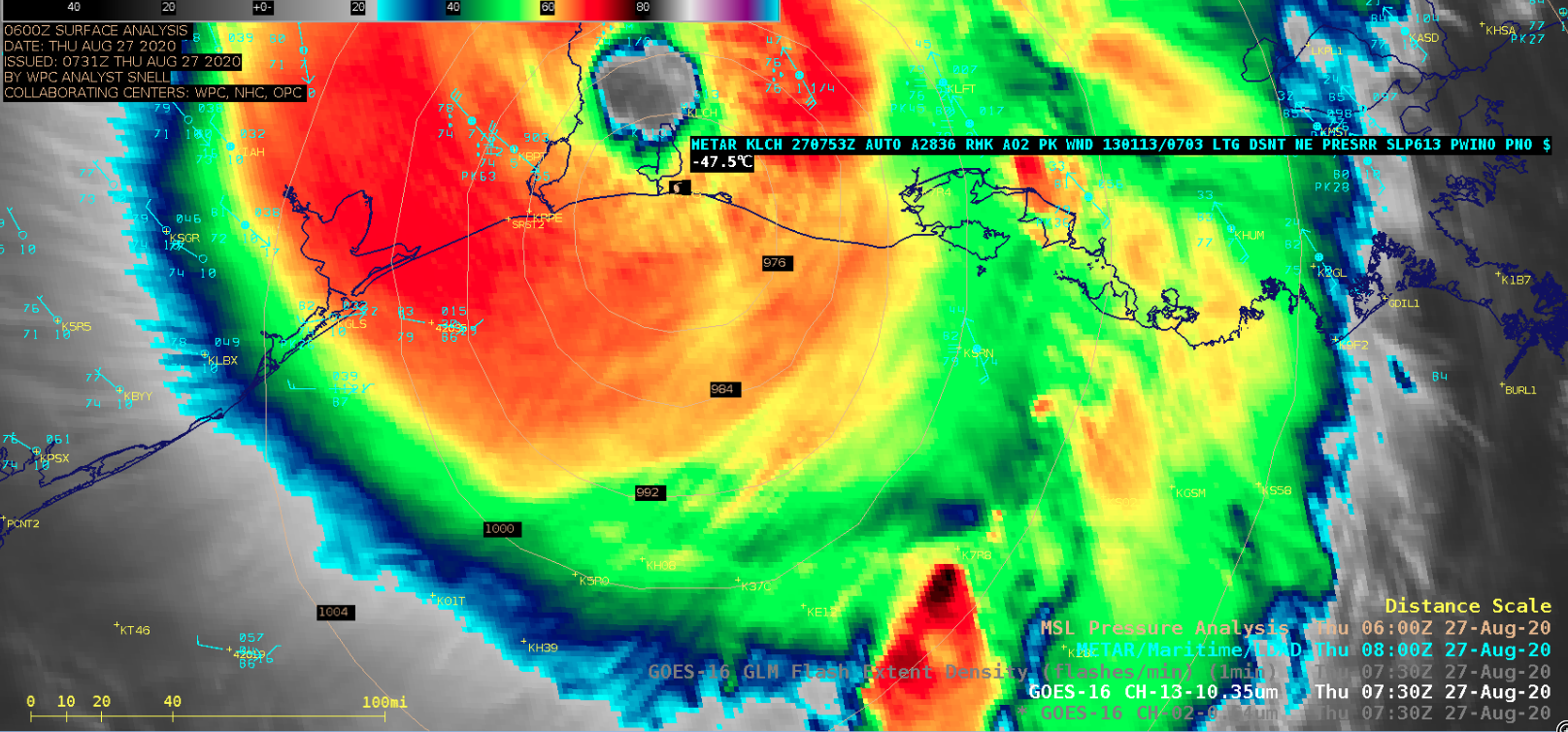
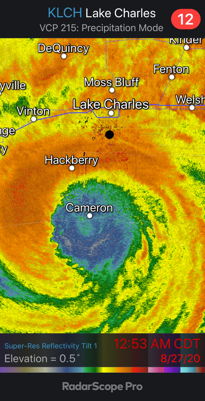
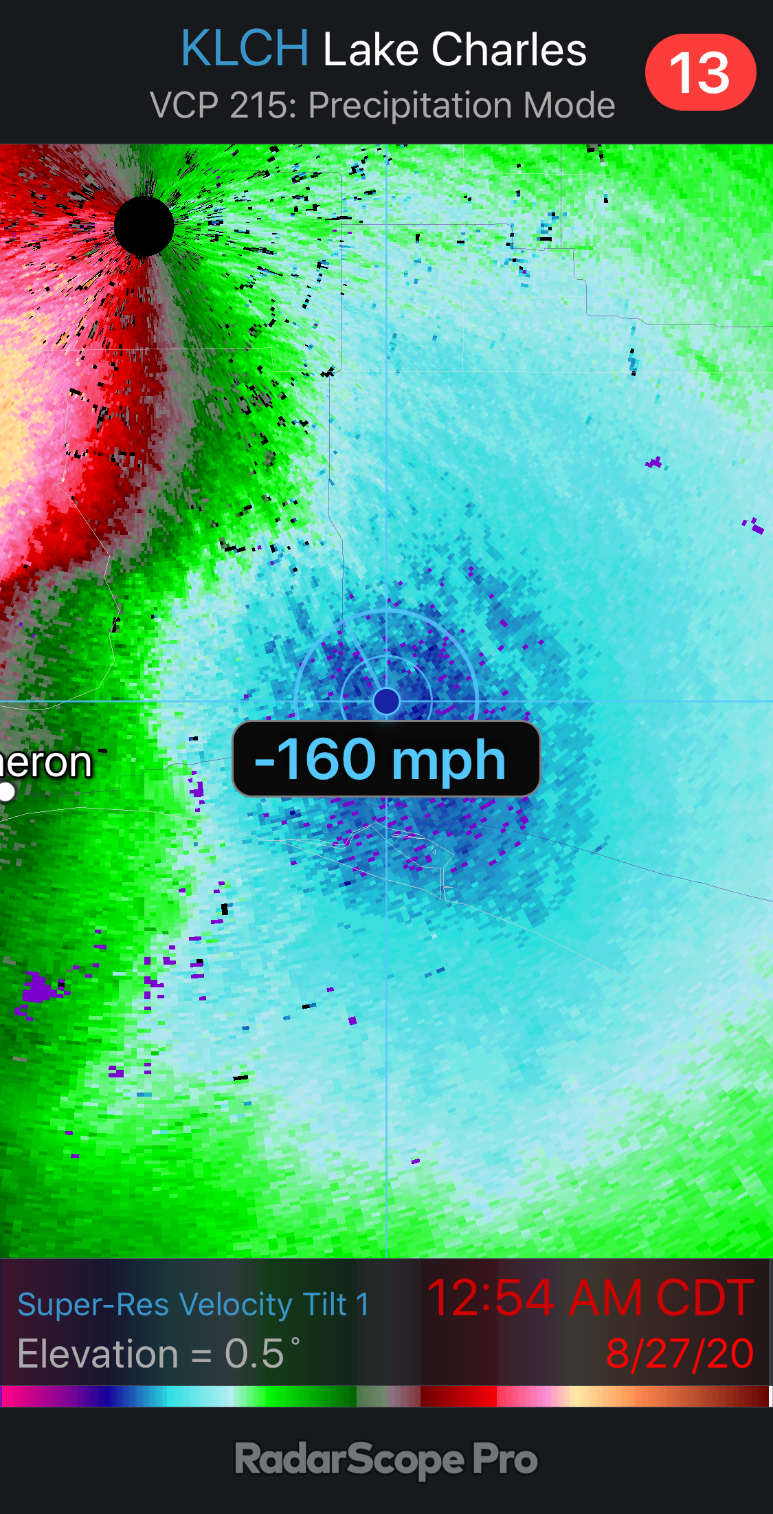
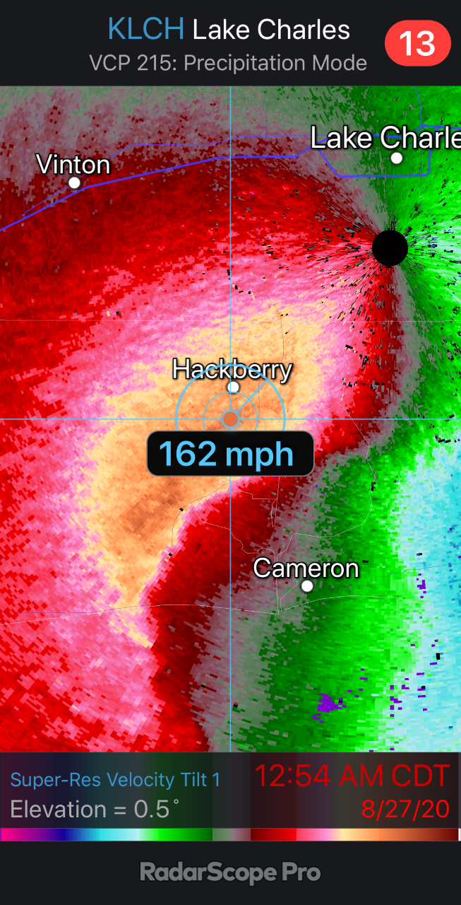
Strong outer convective bands ahead of Laura’s landfall produced isolated tornadoes as it moved onshore (SPC Storm Reports). Peak wind gusts included 116 knots or 133 mph at Lake Charles at 0642 UTC (in addition, Lake Charles reported another peak wind gust of 113 knots or 130 mph at 0703 UTC). Strong winds associated with the northern portion of the eyewall destroyed the Lake Charles radar (YouTube video) — the final reflectivity and velocity images at 0553 UTC (12:53 am CDT) are shown here (the 0.5-degree inbound and outbound radial velocity values were as high as 160-162 mph).
#HurricaneLaura has made landfall near Cameron, LA with max winds of 150 mph – the strongest #hurricane to make landfall in Louisiana since the Last Island Hurricane of 1856 (also 150 mph max winds). pic.twitter.com/QeiHwigs74
— Philip Klotzbach (@philklotzbach) August 27, 2020
![Suomi NPP VIIRS Day/Night Band (0.7 µm) and Infrared Window (11.45 µm) images at 0751 UTC (credit William Straka, CIMSS) [click to enlarge]](https://cimss.ssec.wisc.edu/satellite-blog/images/2020/08/200827_0751utc_suomiNPP_infrared_dayNightBand_Hurricane_Laura_anim.gif)
Suomi NPP VIIRS Day/Night Band (0.7 µm) and Infrared Window (11.45 µm) images at 0751 UTC (credit William Straka, CIMSS) [click to enlarge]
The corresponding Suomi NPP ATMS Microwave (88.2 GHz) and MiRS Rainfall Rate images at 0751 UTC (below) depicted the pattern of precipitation that was spreading inland.
![Suomi NPP ATMS Microwave (88.2 GHz) and MiRS Rainfall Rate images at 0751 UTC (credit William Straka, CIMSS) [click to enlarge]](https://cimss.ssec.wisc.edu/satellite-blog/images/2020/08/200827_0751utc_suomiNPP_microwave_rainfallRate_Hurricane_Laura_anim.gif)
Suomi NPP ATMS Microwave (88.2 GHz) and MiRS Rainfall Rate images at 0751 UTC (credit William Straka, CIMSS) [click to enlarge]
![DMSP-17 SSMI Microwave (85 GHz) image at 0054 UTC [click to enlarge]](https://cimss.ssec.wisc.edu/satellite-blog/images/2020/08/200827_0054utc_dmsp17_ssmis_microwave_Hurricane_Laura.png)
DMSP-17 SSMI Microwave (85 GHz) image at 0054 UTC [click to enlarge]
![GMI Microwave (85 GHz) image at 0255 UTC [click to enlarge]](https://cimss.ssec.wisc.edu/satellite-blog/images/2020/08/200827_0255utc_gmi_microwave_Hurricane_Laura.png)
GMI Microwave (85 GHz) image at 0255 UTC [click to enlarge]
![MIMIC-TC product during the 26-27 August period [click to enlarge]](https://cimss.ssec.wisc.edu/satellite-blog/images/2020/08/200826_200827_mimicTC_Laura_anim.gif)
MIMIC-TC product during the 26-27 August period [click to enlarge]
![GOES-16 Infrared Window (11.2 µm) images, with an overlay of deep-layer wind shear [click to enlarge]](https://cimss.ssec.wisc.edu/satellite-blog/images/2020/08/200826_goes16_infrared_deepLayerWindShear_Laura_anim.gif.gif)
GOES-16 Infrared Window (11.2 µm) images, with an overlay of deep-layer wind shear [click to enlarge]