Tropical Storm Arthur forms off the coast of Florida

GOES-16 “Clean” Infrared Window (10.35 µm) images, with and without an overlay of GLM Flash Extent Density [click to play animation | MP4]
==== 17 May Update =====
![GOES-16 "Red" Visible (0.64 µm) images [click to play animation | MP4]](https://cimss.ssec.wisc.edu/satellite-blog/images/2020/05/200517_goes16_visible_TS_Arthur_anim.gif)
GOES-16 “Red” Visible (0.64 µm) images [click to play animation | MP4]
The corresponding GOES-16 Infrared images — with and without an overlay of GLM Flash Extent Density — are shown below.
![GOES-16 "Clean" Infrared Window (10.35 µm) images, with and without an overlay of GLM Flash Extent Density [click to play animation | MP4]](https://cimss.ssec.wisc.edu/satellite-blog/images/2020/05/200517_goes16_infrared_glmFlashExtentDensity_TS_Arthur_2_anim.gif)
GOES-16 “Clean” Infrared Window (10.35 µm) images, with and without an overlay of GLM Flash Extent Density [click to play animation | MP4]
===== 18 May Update =====
![GOES-16 "Red" Visible (0.64 µm) images [click to play animation | MP4]](https://cimss.ssec.wisc.edu/satellite-blog/images/2020/05/200518_goes16_visible_TS_Arthur_anim.gif)
GOES-16 “Red” Visible (0.64 µm) images [click to play animation | MP4]
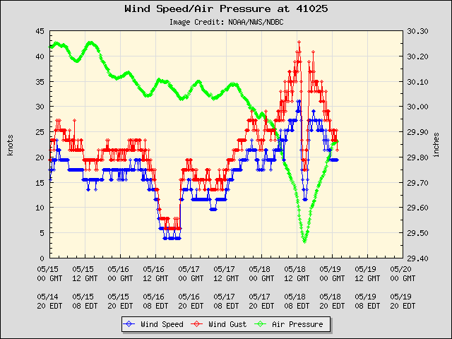
GOES-16 Visible images with plots of Metop ASCAT winds (below) revealed surface winds as high as 37 knots just east of the center of Arthur.
![GOES-16 "Red" Visible (0.64 µm) images, with plots of Metop ASCAT winds [click to play animation | MP4]](https://cimss.ssec.wisc.edu/satellite-blog/images/2020/05/200518_goes16_visible_ascat_TS_Arthur_anim.gif)
GOES-16 “Red” Visible (0.64 µm) images, with plots of Metop ASCAT winds [click to play animation | MP4]