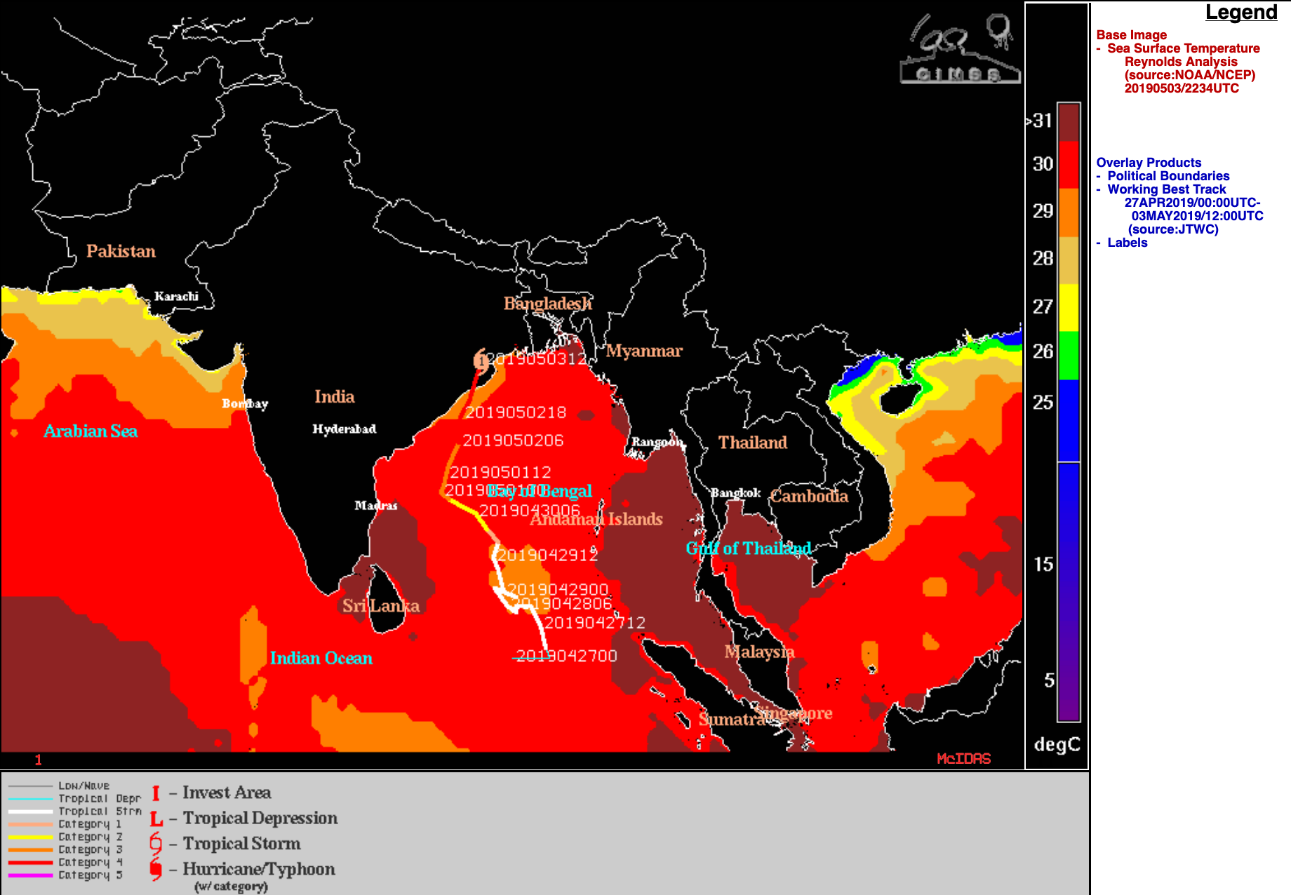
Cyclone Fani makes landfall in India
![EUMETSAT-8 Meteosat-8 Infrared Window (10.8 µm) umages [click to play animation | MP4]](https://cimss.ssec.wisc.edu/satellite-blog/wp-content/uploads/sites/5/2019/05/190502_190503_meteosat8_infrared_Fani_anim.gif)
EUMETSAT Meteosat-8 Infrared Window (10.8 µm) images [click to play animation | MP4]
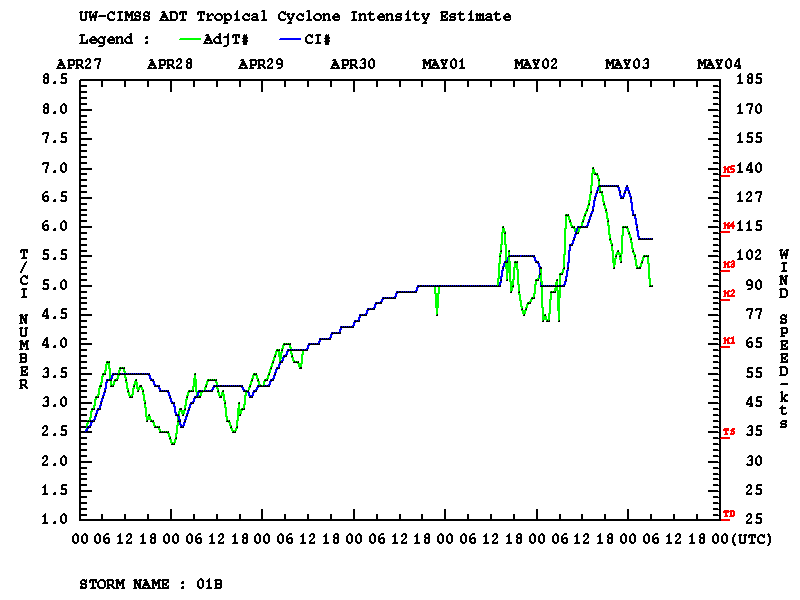
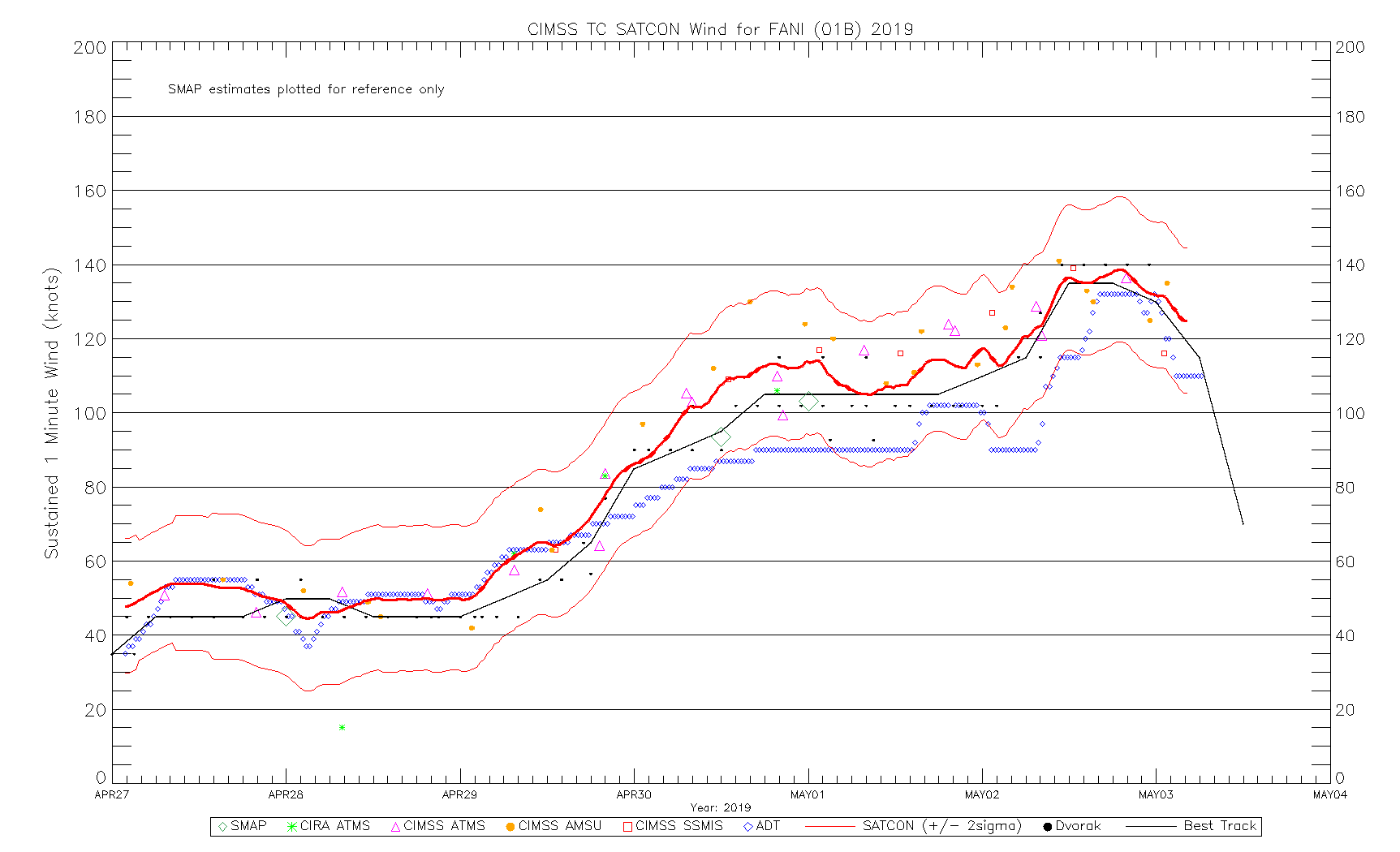
Once inland, Fani was in the process of rapidly weakening to a Category 1 storm as it passed over Bhabaneswar (VEBS), and surface wind gusts to 75 knots were reported at that site (below).
![Time series plot of surface observations from Bhabaneswar, India [click to enlarge]](https://cimss.ssec.wisc.edu/satellite-blog/wp-content/uploads/sites/5/2019/05/190503_VEBS_SFCMG.GIF)
Time series plot of surface observations from Bhabaneswar, India [click to enlarge]
![Sequence of NOAA-20 and Suomi NPP VIIRS Infrared Window (11.45 µm) images [click to enlarge]](https://cimss.ssec.wisc.edu/satellite-blog/wp-content/uploads/sites/5/2019/05/190501_190503_noaa20_suomiNPP_viirs_infrared_Cyclone_Fani_anim.gif)
Sequence of NOAA-20 and Suomi NPP VIIRS Infrared Window (11.45 µm) images [click to enlarge]
![VIIRS True Color RGB and Infrared Window (11.45 µm) images from NOAA-20 and Suomi NPP [click to enlarge]](https://cimss.ssec.wisc.edu/satellite-blog/wp-content/uploads/sites/5/2019/05/190502_noaa20_suomiNPP_viirs_infrared_truecolor_Cyclone_Fani_anim.gif)
VIIRS True Color RGB and Infrared Window (11.45 µm) images from NOAA-20 and Suomi NPP [click to enlarge]
![DMSP-17 SSMIS Microwave (85 GHz) image at 1230 UTC + Meteosat-8 Infrared Window (10.8 µm) image at 1300 UTC [click to enlarge]](https://cimss.ssec.wisc.edu/satellite-blog/wp-content/uploads/sites/5/2019/05/190502_1230utc_dmsp17_microwave_1300utc_meteosat8_infrared_Cyclone_Fani_anim.gif)
DMSP-17 SSMIS Microwave (85 GHz) image at 1230 UTC + Meteosat-8 Infrared Window (10.8 µm) image at 1300 UTC [click to enlarge]
![MIMIC TC morphed microwave product, 01-02 May [click to enlarge]](https://cimss.ssec.wisc.edu/satellite-blog/wp-content/uploads/sites/5/2019/05/190501_190502_mimicTC_Fani_anim.gif)
MIMIC TC morphed microwave product, 01-02 May [click to enlarge]
![Suomi NPP VIIRS Day/Night Band (0.7 µm) and Infrared Window (11.45 µm) images at 1939 UTC on 30 April [click to enlarge]](https://cimss.ssec.wisc.edu/satellite-blog/wp-content/uploads/sites/5/2019/05/190430_1939utc_suomiNPP_viirs_dayNightBand_inraredWindow_Fani_anim.gif)
Suomi NPP VIIRS Day/Night Band (0.7 µm) and Infrared Window (11.45 µm) images at 1939 UTC on 30 April [click to enlarge]
![NOAA-20 VIIRS Day/Night Band (0.7 µm) and Infrared Window (11.45 µm) images at 2029 UTC on 30 April [click to enlarge]](https://cimss.ssec.wisc.edu/satellite-blog/wp-content/uploads/sites/5/2019/05/190430_2029utc_noaa20_viirs_dayNightBand_inraredWindow_Fani_anim.gif)
NOAA-20 VIIRS Day/Night Band (0.7 µm) and Infrared Window (11.45 µm) images at 2029 UTC on 30 April [click to enlarge]