Standing wave west of Tropical Cyclone Pola in the South Pacific
![Himawari-8 Low-level (7.3 µm), Mid-level (6.9 µm) and Upper-level (6.2 µm) Water Vapor images [click to play animation | MP4]](https://cimss.ssec.wisc.edu/satellite-blog/wp-content/uploads/sites/5/2019/02/190226_himawari8_waterVapor_Pola_anim.gif)
Himawari-8 Low-level (7.3 µm), Mid-level (6.9 µm) and Upper-level (6.2 µm) Water Vapor images [click to play animation | MP4]
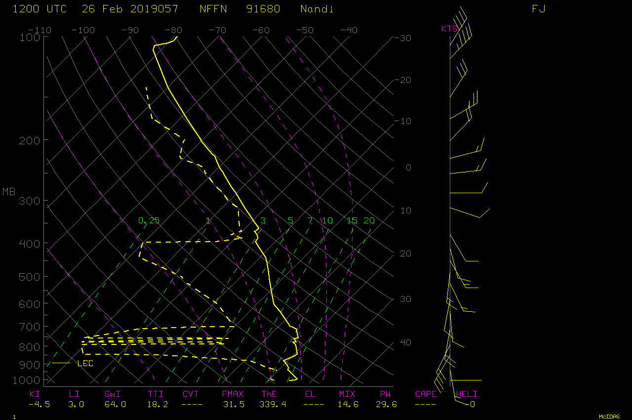
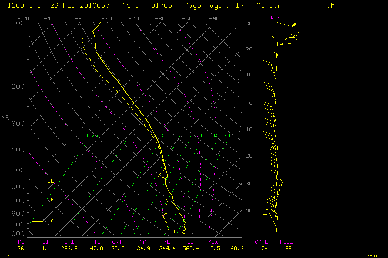
The standing wave feature was also apparent in Himawari-8 “Clean” Infrared Window (10.4 µm) images (below). The abrupt warming of cloud-top infrared brightness temperatures associated with the wave suggests that subsidence was lowering the cloud height. Also note the very cold cloud-top temperatures of -90ºC and colder (yellow pixels embedded within the darker purple enhancement) — this was colder than the tropopause temperature on 12 UTC rawinsonde data from both Nadi, Fiji (NFFN) to the southwest and Pago Pago, American Samoa (NSTU) to the northeast (the wave feature was located closer to the Nadi sounding).
![Himawari-8 "Clean" Infrared Window (10.4 µm) images [click to play animation | MP4]](https://cimss.ssec.wisc.edu/satellite-blog/wp-content/uploads/sites/5/2019/02/190226_himawari8_infrared_Pola_anim.gif)
Himawari-8 “Clean” Infrared Window (10.4 µm) images [click to play animation | MP4]
![VIIRS Infrared Window (11.45 µm) images from NOAA-20 and Suomi NPP [click to enlarge]](https://cimss.ssec.wisc.edu/satellite-blog/wp-content/uploads/sites/5/2019/02/190226_noaa20_suomiNPP_viirs_infrared_Pola_anim.gif)
VIIRS Infrared Window (11.45 µm) images from NOAA-20 and Suomi NPP [click to enlarge]
![Himawari-8 "Red" Visible (0.64 µm) images [click to play animation | MP4]](https://cimss.ssec.wisc.edu/satellite-blog/wp-content/uploads/sites/5/2019/02/190226_himawari8_visible_Pola_anim.gif)
Himawari-8 “Red” Visible (0.64 µm) images [click to play animation | MP4]
![HWRF-P model sounding for the location 15.42ºS 179.75ºW at 18 UTC [click to enlarge]](https://cimss.ssec.wisc.edu/satellite-blog/wp-content/uploads/sites/5/2019/02/190226_18utc_hwrf_sounding_Pola.jpg)
HWRF-P model sounding for the location 15.42ºS/179.75ºW at 18 UTC [click to enlarge]
![Himawari-8 Shortwave Infrared (3.9 µm) images, with plots of GFS 150 hPa winds [click to play animation | MP4]](https://cimss.ssec.wisc.edu/satellite-blog/wp-content/uploads/sites/5/2019/02/190226_himawari8_shortwaveInfrared_Pola_anim.gif)
Himawari-8 Shortwave Infrared (3.9 µm) images, with plots of GFS 150 hPa winds [click to play animation | MP4]
![GOES-17 Infrared and Water Vapor images, with contours of low-level convergence and upper-level divergence at 15 UTC [click to enlarge]](https://cimss.ssec.wisc.edu/satellite-blog/wp-content/uploads/sites/5/2019/02/190226_15utc_lowerConvergence_upperDivergence_TS_Pola_anim.gif)
GOES-17 Infrared and Water Vapor images, with contours of low-level convergence and upper-level divergence at 15 UTC [click to enlarge]