Blowing dust along the southwest coast of Greenland
More #highlatitudedust in #Greenland today! nice contrast of #MODIS and #VIIRS highlight the differences foam, sea-salt and dust aerosols , source is probabl mix of dust+snow @avoiland @jscarto @jobullard @TWMockford @HLCCD pic.twitter.com/xdm1RKoiBu
— Santiago Gassó (@SanGasso) October 14, 2018
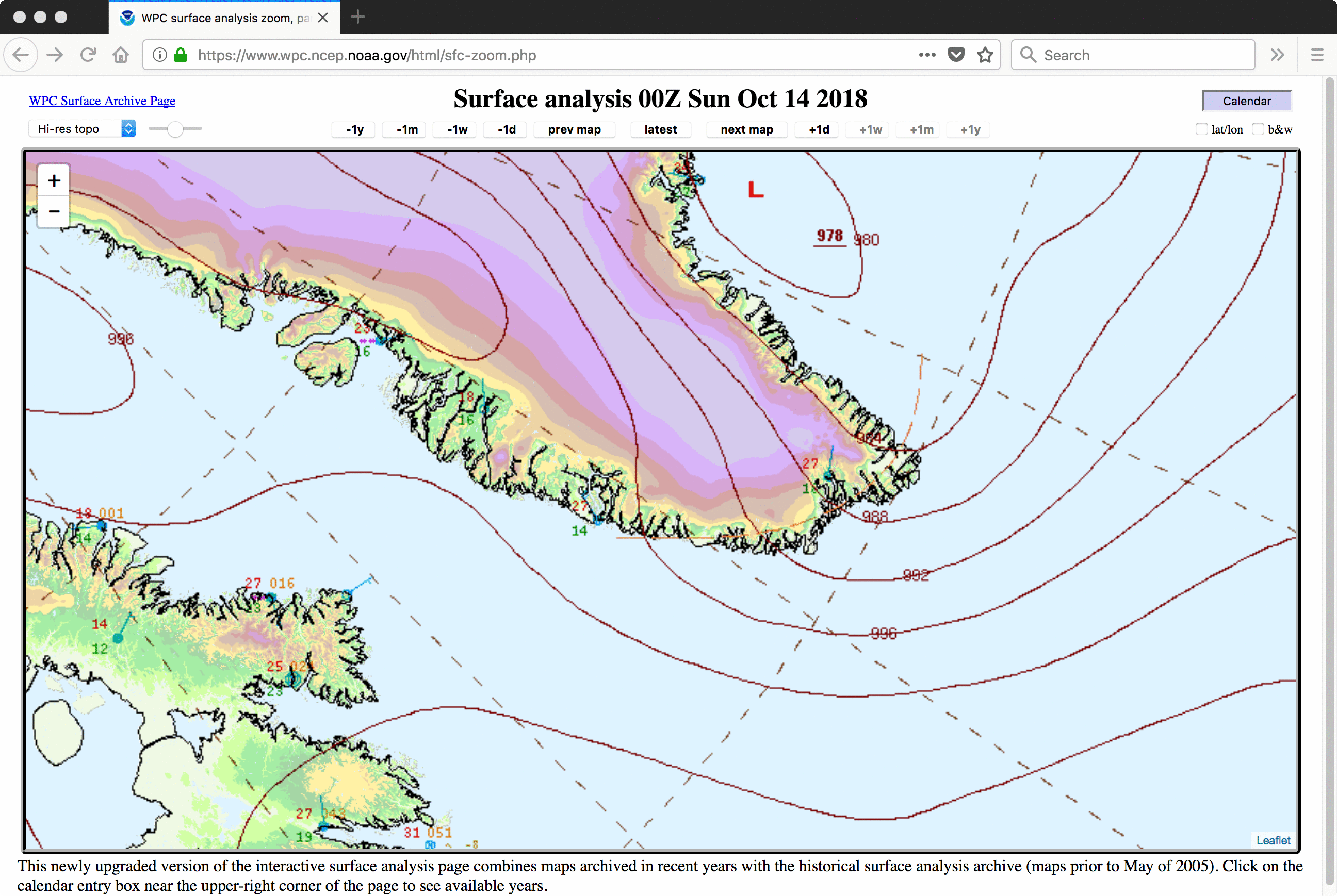
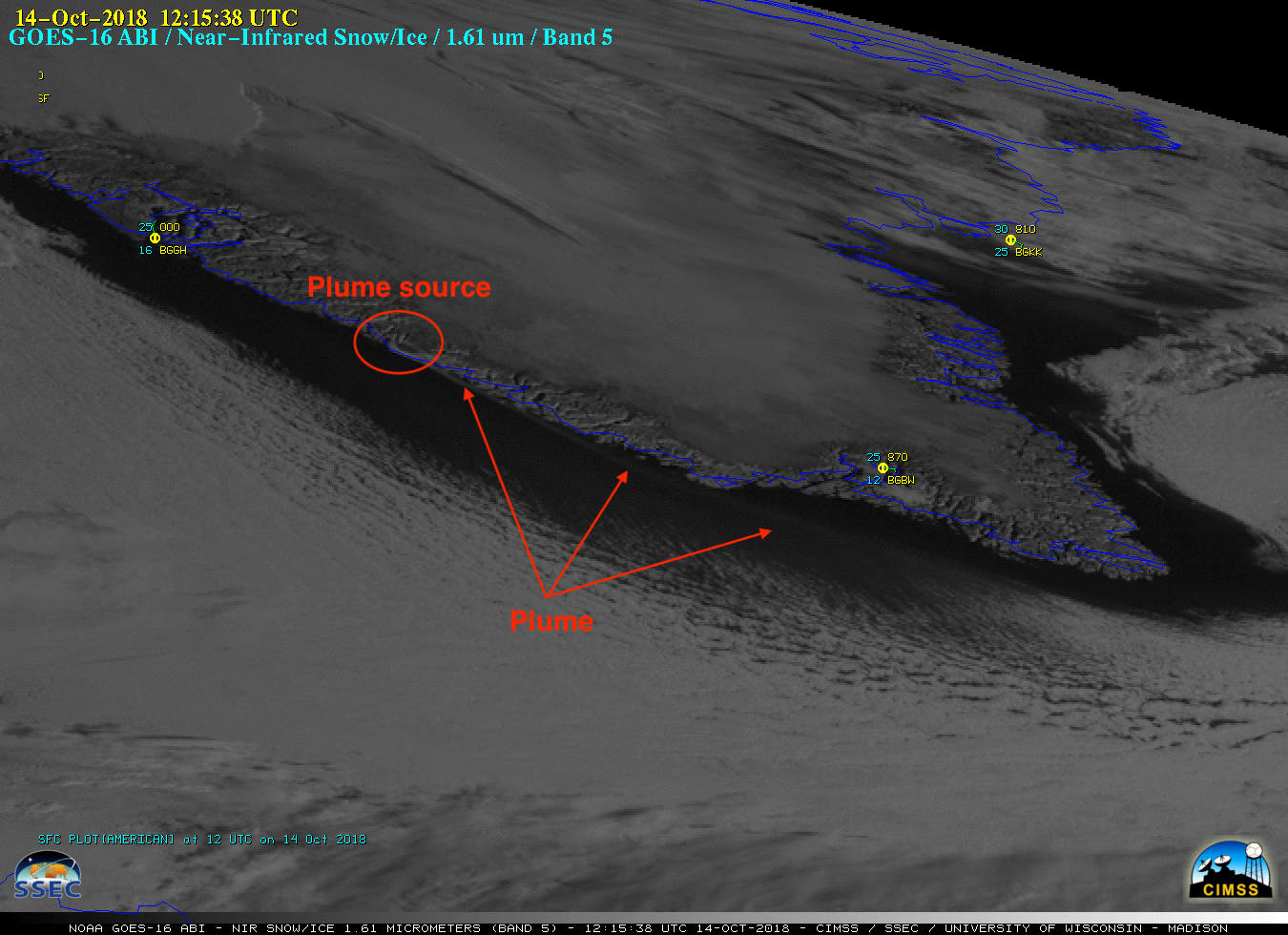
As noted by Santiago Gassó, a long and very narrow plume of airborne dust was evident just off the southwest coast of Greenland on 14 October 2018. Terra MODIS and Suomi NPP VIIRS True Color Red-Green-Blue (RGB) images as viewed using RealEarth are shown below. An exposed (free of snow cover) glacial outlet between Qeqertarsuatsiaat and Paamiut was the point source of the dust plume — the change in water colors (shades of cyan) highlighted the offshore flow of meltwater from this glacier into the Labrador Sea, which then began to curve northward within the West Greenland Current. The strong pressure gradient between high pressure over southern Greenland and a low pressure southeast of the island (surface analyses) along with a passing trough axis caused brisk northerly winds, which lofted the aerosols into the boundary layer.
![Terra MODIS and Suomi NPP VIIRS True Color RGB images [click to enlarge]](https://cimss.ssec.wisc.edu/satellite-blog/wp-content/uploads/sites/5/2018/10/181014_terra_modis_suomiNPP_viirs_truecolor_Greenland_dust_plume_2_anim.gif)
Terra MODIS and Suomi NPP VIIRS True Color RGB images [click to enlarge]

GOES-16 “Red” Visible (0.64 µm) images [click to play animation | MP4]

GOES-16 Near-Infrared “Snow/Ice” (1.61 µm) images [click to play animation | MP4]
* GOES-17 images shown here are preliminary and non-operational *
![GOES-17 "Red" Visible (0.64 µm) images [click to play animation | MP4]](https://cimss.ssec.wisc.edu/satellite-blog/wp-content/uploads/sites/5/2018/10/181014_goes17_visible_Greenland_dust_plume_anim.gif)
GOES-17 “Red” Visible (0.64 µm) images [click to play animation | MP4]
![GOES-17 Near-Infrared "Snow/Ice" (1.61 µm) images [click to play animation | MP4]](https://cimss.ssec.wisc.edu/satellite-blog/wp-content/uploads/sites/5/2018/10/181014_goes17_snow_ice_Greenland_dust_plume_anim.gif)
GOES-17 Near-Infrared “Snow/Ice” (1.61 µm) images [click to play animation | MP4]
/na2018_10_14_287.gif)
![Metop-B ASCAT surface scatterometer winds [click to enlarge]](https://cimss.ssec.wisc.edu/satellite-blog/wp-content/uploads/sites/5/2018/10/181014_1258utc_metopb_ascat.png)
Metop-B ASCAT surface scatterometer winds [click to enlarge]