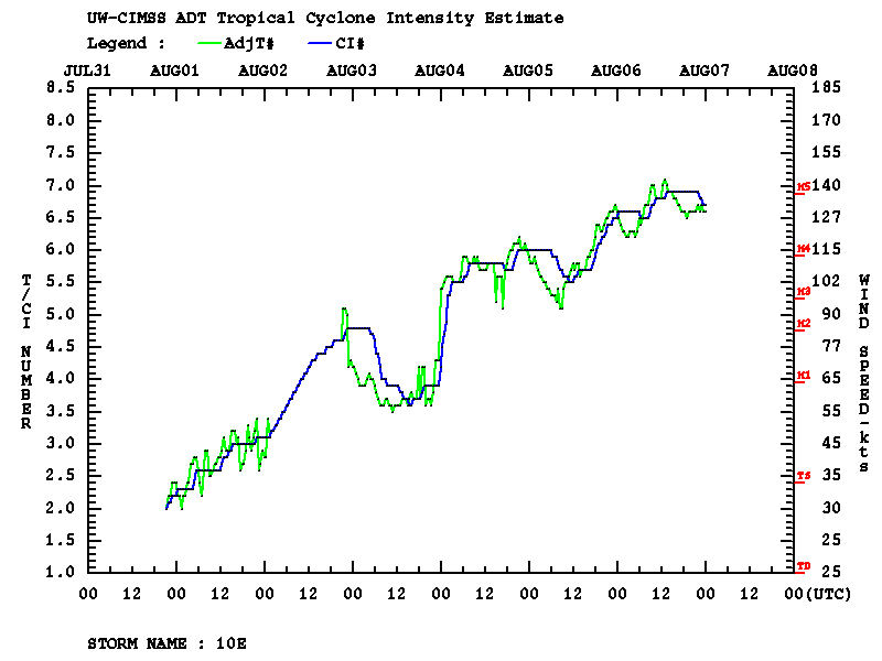
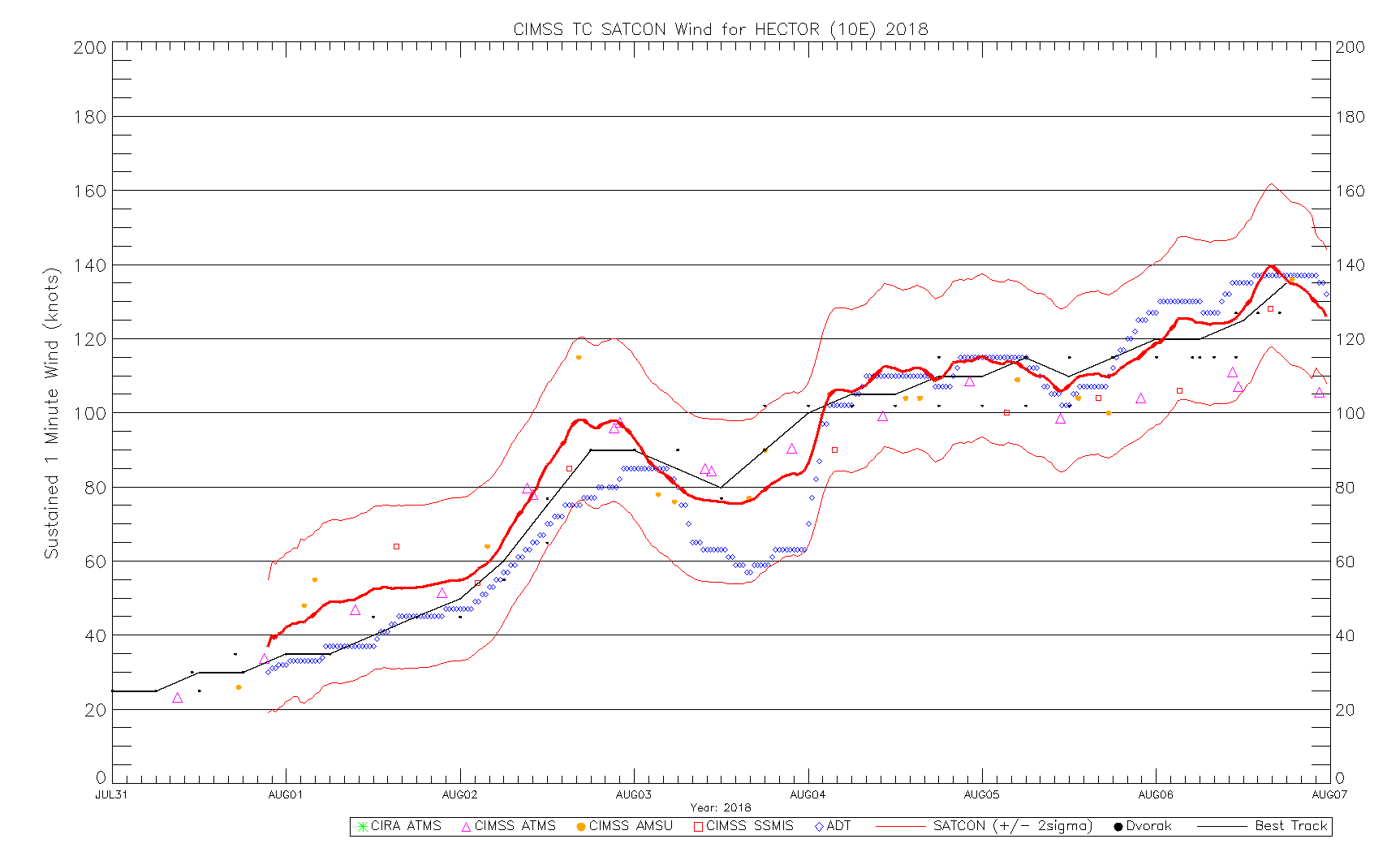
Hurricane Hector
![NOAA-20 and Suomi NPP VIIRS Infrared Window (11.45 µm) images [click to enlarge]](https://cimss.ssec.wisc.edu/satellite-blog/wp-content/uploads/sites/5/2018/08/180806_1027utc_noaa20_1117utc_suomi_npp_viirs_InfraredWindow_Hurricane_Hector_anim.gif)
NOAA-20 and Suomi NPP VIIRS Infrared Window (11.45 µm) images [click to enlarge]
* GOES-17 images shown here are preliminary and non-operational *
A toggle between NOAA-20 and Suomi NPP VIIRS Infrared Window (11.45 µm) images (above; courtesy of William Straka, CIMSS) showed the well-defined eye of Hurricane Hector after it had reached Category 4 intensity on 06 August 2018 (advisories: EPAC | CPAC).
GOES-17 “Red” Visible (0.64 µm) images (below) revealed cloud-top gravity waves within the eyewall region of the storm, along with thin filaments of transverse banding in the northern semicircle farther from the eye.

GOES-17 “Red” Visible (0.64 µm) images [click to play animation | MP4]
![GOES-15 Visible (0.63 µm, left) and Infrared Window (10.7 µm, right) images [click to play animation | MP4]](https://cimss.ssec.wisc.edu/satellite-blog/wp-content/uploads/sites/5/2018/08/180806_goes15_visible_infrared_Hurricane_Hector_anim.gif)
GOES-15 Visible (0.63 µm, left) and Infrared Window (10.7 µm, right) images [click to play animation | MP4]
![GOES-15 Visible (0.63 µm) images [click to play animation | MP4]](https://cimss.ssec.wisc.edu/satellite-blog/wp-content/uploads/sites/5/2018/08/180806_goes15_visible_Hurricane_Hector_anim.gif)
GOES-15 Visible (0.63 µm) images [click to play animation | MP4]
![GOES-15 Infrared Window (10.7 µm) image and Metop ASCAT surface scatterometer winds [click to enlarge]](https://cimss.ssec.wisc.edu/satellite-blog/wp-content/uploads/sites/5/2018/08/180806_1930utc_goes15_ir_ascat_Hurricane_Hector_anim.gif)
GOES-15 Infrared Window (10.7 µm) image and Metop ASCAT surface scatterometer winds [click to enlarge]
![MIMIC-TC morphed microwave product [click to play animation]](https://cimss.ssec.wisc.edu/satellite-blog/wp-content/uploads/sites/5/2018/08/180804_180806_mimic_tc_Hector_anim.gif)
MIMIC-TC morphed microwave product [click to play animation]
===== 07 August Update =====
![NOAA-20 VIIRS Day/Night Band (0.7 µm) and Infrared Window (11.45 µm) images [click to enlarge]](https://cimss.ssec.wisc.edu/satellite-blog/wp-content/uploads/sites/5/2018/08/180807_1148utc_noaa20_DayNightBand_InfraredWindow_Hurricane_Hector_anim.gif)
NOAA-20 VIIRS Day/Night Band (0.7 µm) and Infrared Window (11.45 µm) images [click to enlarge]