Severe Weather in the Pacific Northwest
Infrared Window Channel imagery from COMS-1 (10.8 µm) and GOES-15 (10.7 µm), every 6 hours from 1200 UTC on 7 October through 1800 UTC on 15 October [click to animate]
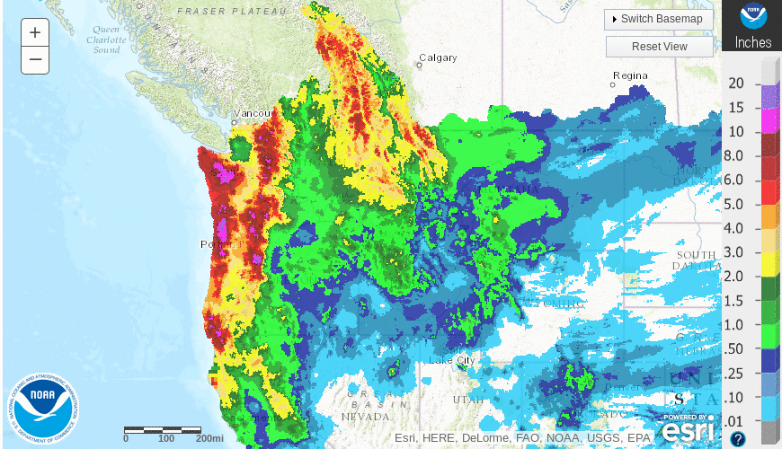
Daily precipitation from the Advanced Hydrologic Prediction Center from 13-15 October is shown here, with a weekly total shown below. A large area of precipitation exceeding 6 inches is apparent in the higher terrain.
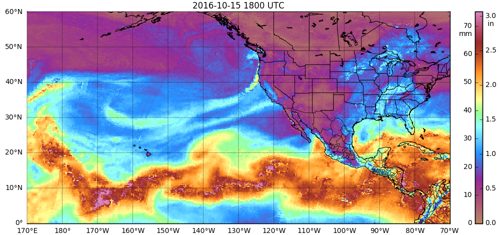
The precipitation amounts were aided by the very moist airmass that accompanied the storms. Total Precipitable Water, shown below, from this site that manipulates data from here, shows the moisture. A larger-scale view that traces the moisture back to the time when Songda first reached typhoon intensity over the West Pacific is available here.
The strong storm before the one spawned by the remnants of Songda produced an EF2-rated tornado in Manzanita Oregon (YouTube Compilation; SPC Storm Reports; Blog post with damage picture) on 14 October 2016. GOES-15 Visible Imagery, below, shows a storm with overshooting tops moving over northwestern Oregon at the time of the tornado. (GOES-15 was performing a full-disk scan from 15:00-15:26 UTC, so 15-imagery was not available as the tornado moved ashore; the Advanced Baseline Imager on GOES-R will produce CONUS Imagery every 5 minutes in addition to Full-Disk Imagery every 15 minutes). The overshoots are especially apparent in the 1500 and 1530 UTC Images. GOES-13 provided a visible image at about the time of the tornado touchdown, but at a very oblique angle. The cirrus shield of the thunderstorm anvil is apparent, however.GOES-15 Visible (0.62 µm) imagery, 1445, 1500 and 1530 UTC on 14 October. The Red Square indicates the tornado location [Click to animate]
We had never issued more than 3 tornado warnings in one day (Oct ’98) (1986-2015) We issued 10 today. #pdxtst
— NWS Portland (@NWSPortland) October 14, 2016
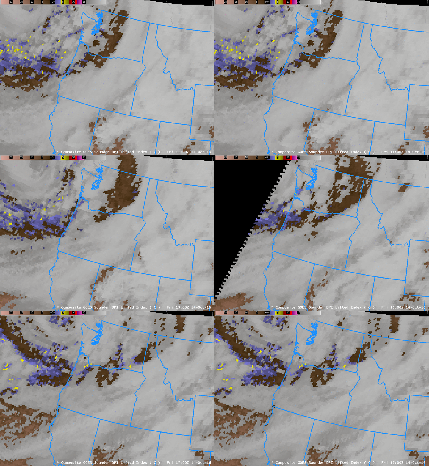
GOES Sounder data can be used to created Derived Product Imagery (DPI) estimates of instability parameters (for example), and many are shown at this site. The GOES-13 Sounder has been offline for about a year after having suffered an anomaly back in November 2015, when the filter wheel became frozen, but the GOES-15 Sounder (and the GOES-14 Sounder) continue to operate. The animation below of GOES-15 Sounder Lifted Index shows values as low as -4ºC upstream of the Oregon Coast for many hours before the tornado; as such, it was a valuable situational awareness tool.
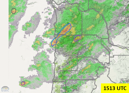
NOAA/CIMSS ProbSevere is a probabilistic estimate that a given thunderstorm will produce severe weather in the next 60 minutes. The animation below shows ProbSevere polygons overlain over radar from 1501 UTC (when the first ProbSevere polygon appeared around the radar cell that ultimately was tornadic) through 1521 UTC. Values from the ProbSevere output are below:
| TIME | PS | CAPE | SHR | MESH | GRW | GLA | FLSHRATE | COMMENTS |
|---|---|---|---|---|---|---|---|---|
| 1501 | 11% | 1048 | 39.3 | 0.00 | str | str | 0 fl/min | Satellite from 1245/1241 |
| 1503 | 32% | 1056 | 39.7 | 0.37 | str | str | 0 fl/min | Satellite from 1245/1241 |
| 1505 | 32% | 1031 | 39.4 | 0.37 | str | str | 0 fl/min | Satellite from 1245/1241 |
| 1507 | 29% | 1013 | 38.7 | 0.37 | str | str | 3 fl/min | Satellite from 1245/1241 |
| 1509 | 47% | 974 | 37.9 | 0.62 | str | str | 3 fl/min | Satellite from 1245/1241 |
| 1511 | 47% | 962 | 37.6 | 0.62 | str | str | 3 fl/min | Satellite from 1245/1241 |
| 1513 | 32% | 745 | 33.1 | 0.52 | str | str | 10 fl/min | Satellite from 1245/1241 |
| 1515 | 34% | 897 | 35.9 | 0.52 | str | str | 1 fl/min | Satellite from 1245/1241 |
| 1517 | 10% | 887 | 35.7 | 0.52 | N/A | N/A | 2 fl/min | |
| 1519 | 8% | 762 | 33.6 | 0.54 | N/A | N/A | 4 fl/min | |
| 1521 | 7% | 737 | 33.1 | 0.49 | N/A | N/A | 2 fl/min |
The Sounder also has a 9.6 µm “ozone absorption band”, and another example of GOES Sounder DPI is Total Column Ozone, shown below. Immediately evident is the sharp gradient in ozone (yellow to green color enhancement) located just north of the polar jet axis that was rounding the base of a large upper-level low (500 hPa analyses). The GOES-R ABI instrument also has a 9.6 µm band that is sensitive to ozone; however, there are no current plans to produce operationally a similar Total Column Ozone product.
![Suomi NPP Day/Night Band Visible (0.70 µm) Image, 1057 UTC on 14 October 2016, Green Arrow points to Manzanita OR [click to enlarge]](https://cimss.ssec.wisc.edu/satellite-blog/wp-content/uploads/sites/5/2016/10/DNB_0.70_1057UTC_14Oct2016.png)
Suomi NPP Day/Night Band Visible (0.70 µm) Image, 1057 UTC on 14 October 2016, Green Arrow points to Manzanita OR [click to enlarge]
Suomi NPP overflew the Pacific Northwest about 4 hours before the severe weather was observed at Manzanita. The Day/Night Visible Image above, courtesy of Jorel Torres at CIRA (Jorel also supplied the NUCAPS Sounding Imagery below), shows a well-developed storm offshore with thunderstorms off the West Coast of the United States (Click here for an image without the Green Arrow). Multiple overshooting tops can be discerned in the imagery.
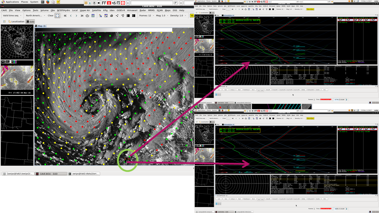
NUCAPS Soundings are produced from the Cross-Track Infrared Sounder (CrIS, with 1300+ channels of information) and the Advanced Technology Microwave Sounder (ATMS, with 22 channels) that are present on Suomi NPP (in addition to the Visible Infrared Imaging Radiometer Suite (VIIRS) instrument that provides the Day/Night band imagery). The image below shows the location of NUCAPS Soundings — the color coding of the points is such that Green points have passed Quality Control, whereas yellow points denote sounding for which the Infrared Sounding retrieval has failed to converge and Red points denote soundings for which both Infrared and Microwave sounding retrievals have failed to converge).
Suomi NPP Day/Night Band Visible Image, 1057 UTC on 14 October 2016, with NUCAPS Sounding Locations indicated. The Green Circle shows the location of the Sounding below; Refer to the text for the Dot Color meaning [click to enlarge]
NUCAPS Soundings can give valuable information at times other than those associated with radiosonde launches (0000 and 1200 UTC, typically), and over a broad region. The point highlighted above, between the occluded storm and the coast, shows very steep mid-level lapse rates that suggest convective development is likely.
The imagery below shows soundings a bit farther south, near convection that looks supercellular. The NUCAPS Soundings there suggest very steep mid-level lapse rates.


![GOES-15 Sounder Total Column Ozone DPI [click to animate]](https://cimss.ssec.wisc.edu/satellite-blog/wp-content/uploads/sites/5/2016/10/snoz_ligmdmba.16287.1800.gif)
