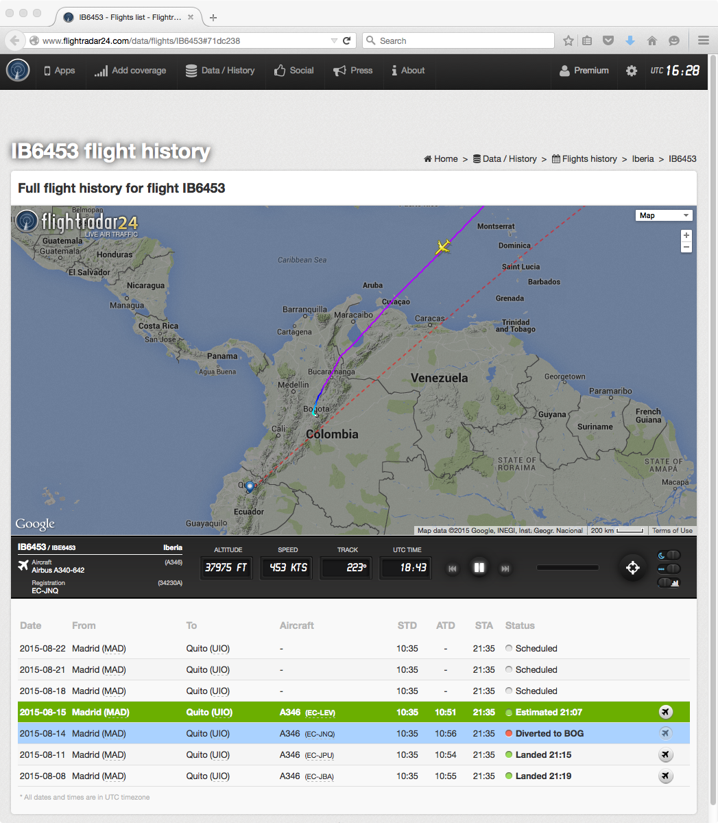
Eruption of the Cotopaxi volcano in Ecuador
![GOES-13 visible (0.63 µm) images [click to play animation]](https://cimss.ssec.wisc.edu/satellite-blog/wp-content/uploads/sites/5/2015/08/150814_goes13_visible_Cotopaxi_volcano_anim.gif)
GOES-13 visible (0.63 µm) images [click to play animation]
The corresponding GOES-13 infrared (10.7 µm) images (below; click image to play animation) showed that cloud-top IR brightness temperatures were as cold a -53º C (orange color enhancement) at 1915 UTC.
![GOES-13 infrared (10.7 µm) images [click to play animation]](https://cimss.ssec.wisc.edu/satellite-blog/wp-content/uploads/sites/5/2015/08/150814_goes13_ir_Cotopaxi_volcano_anim.gif)
GOES-13 infrared (10.7 µm) images [click to play animation]
![GOES-13 water vapor (6.5 µm) images [click to play animation]](https://cimss.ssec.wisc.edu/satellite-blog/wp-content/uploads/sites/5/2015/08/150814_goes13_water_vapor_Cotopaxi_volcano_anim.gif)
GOES-13 water vapor (6.5 µm) images [click to play animation]
![Aqua MODIS true-color images [click to enlarge]](https://cimss.ssec.wisc.edu/satellite-blog/wp-content/uploads/sites/5/2015/08/150814_aqua_modis_truecolor_Cotopaxi_anim.gif)
Aqua MODIS true-color images [click to enlarge]
![Suomi NPP VIIRS true-color image [click to enlarge]](https://cimss.ssec.wisc.edu/satellite-blog/wp-content/uploads/sites/5/2015/08/150814_1858utc_viirs_truecolor_Cotopaxi_google.png)
Suomi NPP VIIRS true-color image [click to enlarge]
![Suomi NPP VIIRS visible (0.64 µm) and infrared (11.45 µm) images [click to enlarge]](https://cimss.ssec.wisc.edu/satellite-blog/wp-content/uploads/sites/5/2015/08/150814_1858utc_suomi_npp_viirs_visible_ir_Cotopaxi_anim.gif)
Suomi NPP VIIRS visible (0.64 µm) and infrared (11.45 µm) images [click to enlarge]