Multi-day outbreak of pyrocumulonimbus clouds across southeastern Australia
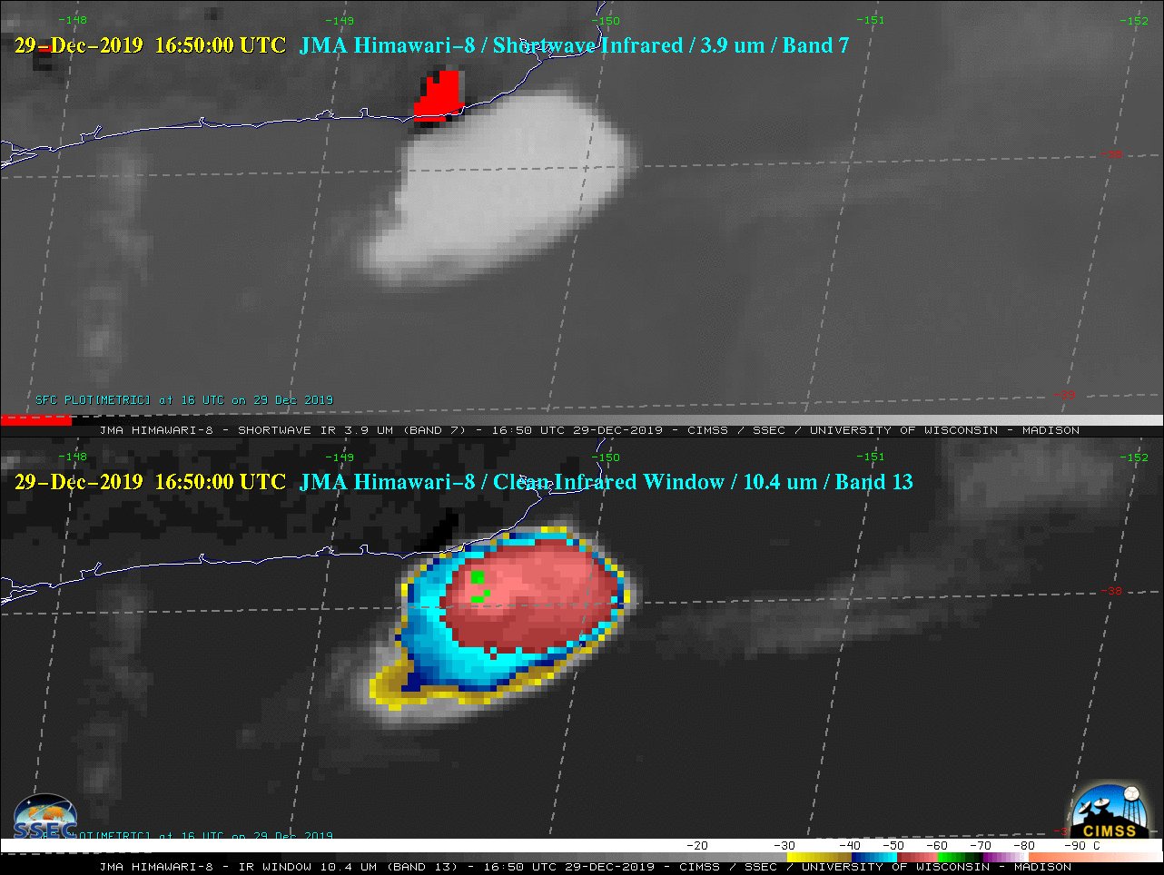
![Himawari-8 Shortwave Infrared (3.9 µm, top) and Longwave Infrared Window (10.4 µm, bottom) images [click to play animation | MP4]](https://cimss.ssec.wisc.edu/satellite-blog/images/2019/12/191229_himawari8_shortwaveInfrared_longwaveInfrared_Australia_pyroCb_anim.gif)
Himawari-8 Shortwave Infrared (3.9 µm, top) and Longwave Infrared Window (10.4 µm, bottom) images [click to play animation | MP4]
The coldest cloud-top 10.4 µm infrared brightness temperature was -62.6ºC (darker green pixels) at 1650 UTC. According to rawinsonde data from Melbourne (below), this corresponded to an altitude near 13 km.
![Plots of rawinsonde data from Melbourne, Australia [click to enlarge]](https://cimss.ssec.wisc.edu/satellite-blog/images/2019/12/191229_YMML_RAOBS.GIF)
Plots of rawinsonde data from Melbourne, Australia [click to enlarge]
![w (11.45 µm) images from NOAA-20 and Suomi NPP [click to enlarge]](https://cimss.ssec.wisc.edu/satellite-blog/images/2019/12/191229_noaa20_suomiNPP_viirs_infrared_Australia_pyroCb_anim.gif)
VIIRS Infrared Window (11.45 µm) images from NOAA-20 and Suomi NPP [click to enlarge]
===== 30 December Update =====
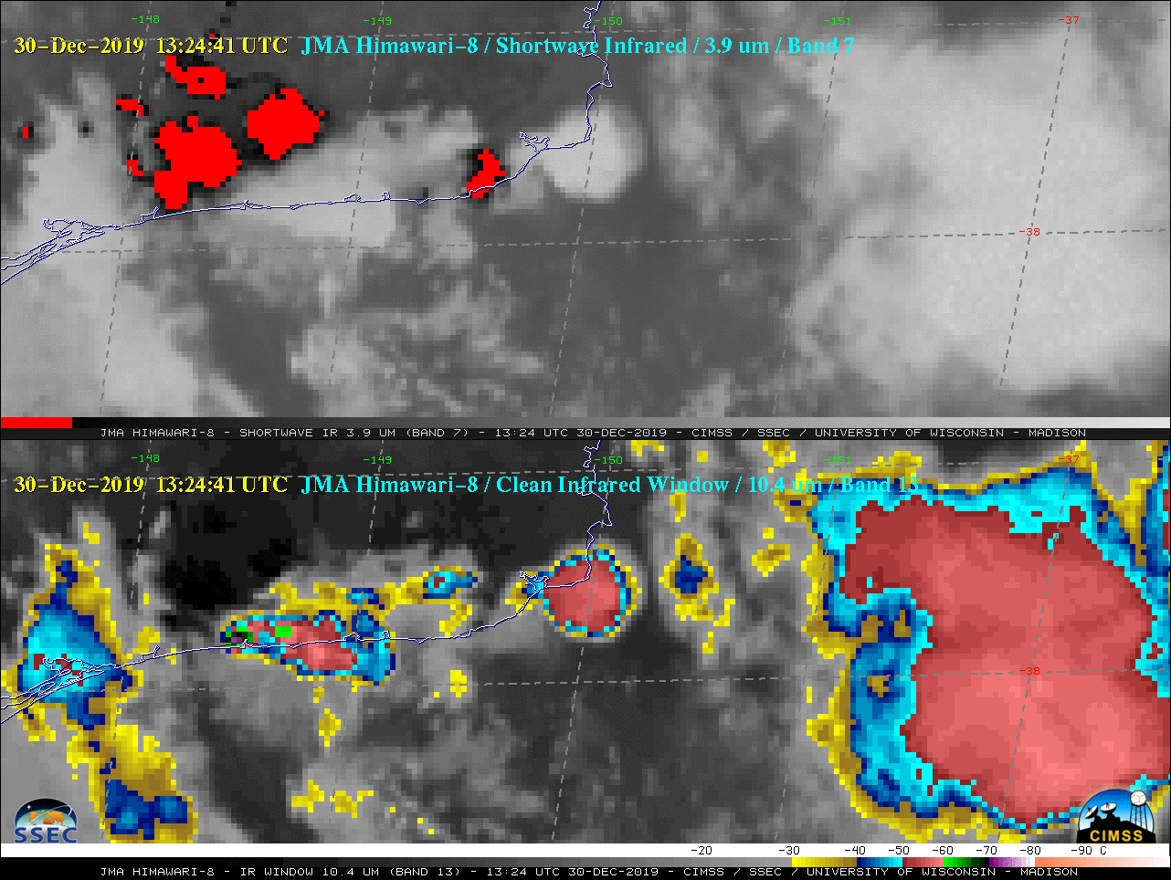
![Himawari-8 Shortwave Infrared (3.9 µm, top) and Longwave Infrared Window (10.4 µm, bottom) images [click to play animation | MP4]](https://cimss.ssec.wisc.edu/satellite-blog/images/2019/12/191229_191230_himawari8_target_shortwaveInfrared_longwaveInfrared_Australia_pyroCbs_anim.gif)
Himawari-8 Shortwave Infrared (3.9 µm, top) and Longwave Infrared Window (10.4 µm, bottom) images [click to play animation | MP4]
The coldest Himawari-8 cloud-top 10.4 µm brightness temperature on 30 December was -73.15ºC at 13:24:41 UTC (violet pixel near the coast); this was 5ºC colder than the coldest temperature of -68.1ºC — at an altitude of 15 km — on 12 UTC rawinsonde data from Melbourne (below). During the 12-hour period between the 2 soundings, the coded tropopause ascended from a height of 13.1 km (-63.7ºC) at 00 UTC to 14.2 km (-67.5ºC) at 12 UTC.
![Plots of rawinsonde data from Melbourne, Australia at 00 UTC (yellow) and 12 UTC (cyan) [click to enlarge]](https://cimss.ssec.wisc.edu/satellite-blog/images/2019/12/191230_00UTC_12UTC_YMML_RAOBS.GIF)
Plots of rawinsonde data from Melbourne, Australia at 00 UTC (yellow) and 12 UTC (cyan) [click to enlarge]
![VIIRS Infrared Window (11.45 µm) images from NOAA-20 and Suomi NPP [click to enlarge]](https://cimss.ssec.wisc.edu/satellite-blog/images/2019/12/191230_14utc_noaa20_15utc_suomiNPP_viirs_infrared_Australia_pyroCb_anim.gif)
VIIRS Infrared Window (11.45 µm) images from NOAA-20 and Suomi NPP [click to enlarge]
===== 31 December Update =====
![Suomi NPP VIIRS Day/Night Band, Shortwave Infrared, Near-Infrared & Active Fire Product images at 1455 UTC on 31 December (credit: William Straka, CIMSS) [click to enlarge]](https://cimss.ssec.wisc.edu/satellite-blog/images/2019/12/191231_1455utc_suomiNPP_viirs_dayNightBand_shortwaveInfrared_nearInfrared_activeFireProduct_Australia_anim.gif)
Suomi NPP VIIRS Day/Night Band (0.7 µm), Shortwave Infrared (3.75 µm and 4.05 µm), Near-Infrared (1.61 µm and 2.25 µm) & Active Fire Product images at 1455 UTC on 31 December (credit: William Straka, CIMSS) [click to enlarge]
Plot shows temperature recorded at #Mallacoota Airport earlier this morning. https://t.co/Qc5Nzwhqr4 Stay up to date @CFA_Updates @vicemergency pic.twitter.com/1eOKky0oAd
— Bureau of Meteorology, Victoria (@BOM_Vic) December 30, 2019
A sequence of daily Aqua MODIS True Color RGB images with an overlay of VIIRS Fire Radiative Power showed the fires and smoke during the 29-31 December period (below).
![Aqua MODIS True Color RGB images with an overlay of VIIRS Fire Radiative Power [click to enlarge]](https://cimss.ssec.wisc.edu/satellite-blog/images/2019/12/191229_191231_aqua_modis_trueColorRGB_viirs_fireRadiativePower_Australia_anim.gif)
Aqua MODIS True Color RGB images with an overlay of VIIRS Fire Radiative Power [click to enlarge]
A multi-day Himawari-8 GeoColor animation covering the period 28 December – 01 January is available here.