All Research
Research Categories | All Research Projects
-

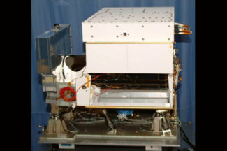
Absolute Radiance Interferometer for the CLARREO Pathfinder (ARI)
The Absolute Radiance Interferometer is an instrument developed by SSEC scientists and engineers that is capable of measuring infrared radiation in Earth’s atmosphere to a high-degree of accuracy. Roughly the size of a small freezer, the ARI is designed to be flight ready for future satellite missions.
Contact:
Hank Revercomb, Joe TaylorCategories:
Instruments -
Atmospheric Emitted Radiance Interferometer (AERI)
A ground-based instrument developed by SSEC, the Atmospheric Emitted Radiance Interferometer (AERI) measures temperature, water vapor, and trace gases in the boundary layer.
Website:
http://www.ssec.wisc.edu/aeri/Contact:
Jonathan Gero (PI), Denny HackelCategories:
Instruments, SurfaceSponsors:
DOE -
Atmospheric Infrared Sounder (AIRS)
SSEC scientists have helped calibrate the Atmospheric Infrared Sounder (AIRS) onboard the Aqua satellite and currently validate its data, develop algorithms to make the data useful, and write software for processing the data from direct broadcast facilities.
Contact:
David Tobin, Joe TaylorCategories:
Low-Earth Orbiting SatellitesSponsors:
NASA -
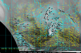
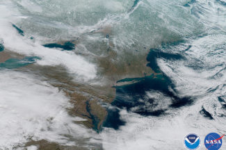
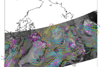
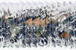
Atmospheric Motion Vector Research
SSEC is known for its pioneering work with atmospheric motion vectors (AMVs) to track wind patterns by analyzing numerous sets of satellite images. These include AMVs from geostationary (GEO) satellite observations over mid-latitudes and the tropics and AMVs from low earth-orbiting (LEO) satellites over polar regions.
Contact:
Dave StettnerCategories:
Clouds, Geostationary Satellites, Low-Earth Orbiting Satellites -
CIMSS GOES/GOES-R LAP Validation Tool
This tool validates operational GOES-R Advanced Baseline Imager (ABI) Legacy Atmospheric profile (LAP) retrieval products, focusing on parameters such as TPW, atmospheric stability indices, temperature/water vapor profiles.
Website:
https://soundingval.ssec.wisc.edu/Contact:
Zhenglong Li (PI)Categories:
Geostationary SatellitesSponsors:
NOAA -
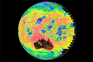
Clouds from AVHRR Extended (CLAVR-x)
The Clouds from AVHRR extended (CLAVR-x) system processes cloud data for NOAA operations using the AVHRR instrument on the NOAA-POES and EUMETSAT-METOP series of polar orbiting satellites.
Website:
https://www.ssec.wisc.edu/clavrx/Contact:
Andrew Heidinger, NOAA, Michael Foster (PI)Categories:
CloudsSponsors:
NOAA -
Community Satellite Processing Package (CSPP) Geo
The Community Satellite Processing Package (CSPP) Geo is free open source software developed to support Direct Broadcast (DB) users with processing geostationary satellite data to generate geophysical products.
Website:
http://cimss.ssec.wisc.edu/csppgeo/Contact:
Graeme Martin, Ray GarciaCategories:
Geostationary Satellites, Visualization and softwareSponsors:
NOAA -
Community Satellite Processing Package (CSPP) Leo
The Community Satellite Processing Package (CSPP) Leo is free open source software developed to support Direct Broadcast (DB) users with processing polar-orbiting satellite data for regional products and applications.
Website:
http://cimss.ssec.wisc.edu/cspp/Contact:
Liam Gumley (PI), Kathy StrabalaCategories:
Low-Earth Orbiting Satellites, Visualization and software -
Cross-track Infrared Sounder (CrIS)
In preparation for JPSS-1 and for the current Suomi NPP, SSEC and CIMSS scientists are integrally involved in the pre-launch design and testing, as well as post-launch plans to assess the quality of the Cross-track Infrared Sounder (CrIS) data.
Contact:
David Tobin, Joe TaylorCategories:
Low-Earth Orbiting Satellites -
Data Assimilation
SSEC scientists conduct research to improve satellite data assimilation techniques in operational weather forecast models.
Contact:
Agnes Lim, Zhenglong LiCategories:
Modeling and data assimilationSponsors:
NOAA -
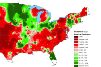
Drought Research
Our work focuses on using satellite observations and model reanalysis datasets to develop new tools to detect, monitor, and forecast rapidly intensifying flash drought events. We also work with decision-makers to better understand and address their drought information needs.
Contact:
Jason Otkin (PI)Categories:
HazardsSponsors:
NOAA -
Educational Software
Learn more about weather and climate through these educational applets.
Website:
https://cimss.ssec.wisc.edu/wxfest/Contact:
Tim WagnerCategories:
Visualization and software -
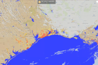
Flood Research
Through a collaboration with scientists at George Mason University, researchers at SSEC and CIMSS routinely generate flood detection products from a suite of satellites including polar (SNPP & NOAA-20) and geostationary (GOES-East, GOES-West, and AHI-8) satellites in near realtime.
Contact:
Jay HoffmanCategories:
Hazards, Visualization and softwareSponsors:
NOAA -
Future Weather Satellite System Design and Science Studies
Scientists will partner with NOAA to accelerate the operational readiness of new observing systems and technology in ways that reduce cost and risk.
Contact:
Brad Pierce, Tristan L’EcuyerCategories:
Geostationary Satellites, Low-Earth Orbiting SatellitesSponsors:
NOAA -
GOES-R series activities at SSEC/CIMSS
From helping to formulate the Advanced Baseline Imager, to developing algorithms and advanced products, SSEC and CIMSS scientists are now using the more timely and detailed observations of GOES-R to enhance our research of Earth’s atmosphere and weather.
Website:
https://cimss.ssec.wisc.edu/goes-r/Contact:
Mathew Gunshor, Wayne FeltzCategories:
Geostationary SatellitesSponsors:
NOAA -
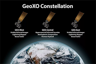
Geostationary Extended Observations (GeoXO)
Scientists will collaborate with NOAA to prepare for the next generation satellite systems beyond GOES-R, including looking at new orbits, sensors, satellite options, as well as commercial partnerships.
Contact:
Brad Pierce, Tristan L’EcuyerCategories:
Geostationary SatellitesSponsors:
NOAA -
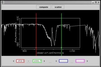
Geostationary Hyperspectral IR Sounder
The nation’s current GOES-R series do not have a geostationary (GEO) hyperspectral IR sounder, while several international agencies have or are developing such a capability. The GEO hyperspectral IR sounders will greatly enhance the current forecast capability by providing critical high temporal resolution sounding information.
Contact:
Zhenglong Li, David TobinCategories:
Geostationary SatellitesSponsors:
NOAA -
Hazus-MH Based Project Support
Hazus-MH, created in partnership with the Federal Emergency Management Administration (FEMA), uses Geographic Information Systems (GIS) technology to estimate physical, economic, and social impacts of disasters such as earthquakes, hurricane winds, and floods.
Contact:
Shane Hubbard (PI)Categories:
Hazards, Modeling and data assimilationSponsors:
FEMA -

High Performance Computing Data Processing: NOAA ASSISTT Enterprise
Researchers will work with NOAA to support the transition of algorithms to operations.
Contact:
Ray Garcia, William StrakaCategories:
Modeling and data assimilationSponsors:
NOAA -
Hyper-spectral Viewer for Development of Research Applications (HYDRA)
HYDRA software allows for the analysis and visualization of multispectral and hyperspectral data acquired from weather satellites.
Website:
http://www.ssec.wisc.edu/hydra/Contact:
Thomas RinkCategories:
Visualization and softwareSponsors:
NOAA -
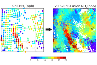
Imager and Sounder Fusion
CIMSS scientists have been investigating imager data fusion with sounder data and products to construct spectral bands and sounding products at imager spatial (and temporal for GEO) resolution.
Contact:
Elisabeth WeiszCategories:
Geostationary Satellites, Low-Earth Orbiting Satellites -
Infrared Atmospheric Sounding Interferometer/Infrared Atmospheric Sounding Interferometer Next Generation (IASI/IASI NG)
To validate the measurements and to conduct studies, SSEC researchers compare data from the Infrared Atmospheric Sounding Interferometer (IASI) on the European MetOp satellite with data from other sounders, such as the Atmospheric Infrared Sounder (AIRS) and the Cross-track Infrared Sounder (CrIS).
Contact:
David Tobin, Joe TaylorCategories:
Low-Earth Orbiting SatellitesSponsors:
NASA -
Infusing satellite Data into Environmental Applications – International (IDEA-I)
The Infusing satellite Data into Environmental Applications – International (IDEA-I) develops satellite-based aerosol forecasting, visualization, and data synthesis tools for use by the international air quality forecasting community.
Contact:
Brad Pierce (PI)Categories:
Atmospheric Composition, Visualization and software -
International Satellite Training
Scientists will collaborate with Taiwan Central Weather Bureau scientists to develop products for the Himawari satellite based on CIMSS’s product development experience for GOES-16 and -17.
Contact:
Mike FosterCategories:
Geostationary Satellites, TrainingSponsors:
NOAA -
Joint Polar Satellite System (JPSS)
SSEC and CIMSS scientists are involved in calibration and validation work to ensure the instruments on board the Joint Polar Satellite System satellites return accurate measurements that will support future research.
Contact:
Lori Borg, David Tobin, Wayne FeltzCategories:
Low-Earth Orbiting Satellites -
MODIS-VIIRS Continuity Cloud Products
The NASA MODerate-resolution Imaging Spectroradiometer (MODIS) and Suomi National Polar-Orbiting Partnership (SNPP) Visible Infrared Imaging Radiometer Suite (VIIRS) cloud products represent an effort to establish a continuous, multi-decadal climate data record for clouds.
Contact:
Robert HolzCategories:
CloudsSponsors:
NOAA -

Man Computer Interactive Data Access System (McIDAS-V)
McIDAS-V is a free, Java-based, open-source software package that allows for visualization and analysis of data retrieved from weather satellites.
Contact:
Dave Santek, Becky SchafferCategories:
Visualization and softwareSponsors:
NOAA -

Mesoscale Winds
We are estimating wind vectors by applying an optical flow technique to one-minute imagery from GOES-16.
Contact:
Dave StettnerCategories:
Geostationary Satellites, HazardsSponsors:
NOAA -
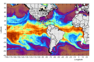
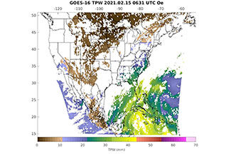
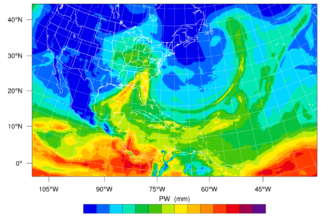
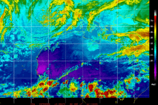
Morphed Integrated Microwave Imagery at CIMSS – Total Precipitable Water (MIMIC-TPW)
MIMIC-TPW is a technique that combines microwave observations from polar orbiting satellites to create near-seamless hourly imagery of global total precipitable water (TPW).
Contact:
Tony WimmersCategories:
Modeling and data assimilation, Tropical CyclonesSponsors:
NOAA -
NOAA Weather Satellite Proving Ground Testbeds
The Hazardous Weather Testbed provides a platform to test new research and develop improved methods and technologies that support the advancement of severe weather forecasts and warnings.
Contact:
Tim Wagner, Wayne FeltzSponsors:
NOAA -
Pathfinder Atmospheres – Extended (PATMOS-x)
The Pathfinder Atmospheres – Extended (PATMOS-x) project team derives atmospheric and surface records from NOAA’s Advanced Very High Resolution Radiometer (AVHRR) data over the last 25 years.
Website:
http://cimss.ssec.wisc.edu/patmosx/Contact:
Andrew Heidinger, NOAA, Mike FosterCategories:
CloudsSponsors:
NOAA -
Polar Winds
The Visible Infrared Imaging Radiometer Suite (VIIRS), the MODerate-resolution Imaging Spectroradiometer (MODIS), and the Advanced Very High Resolution Radiometer (AVHRR) are being used to generate high-latitude wind fields by tracking cloud and water vapor features in infrared window and water vapor bands with these applications expanded to LEO-GEO and Sounder based winds.
Contact:
Dave Santek, Rich DworakCategories:
Low-Earth Orbiting Satellites, Polar ResearchSponsors:
NOAA -
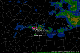
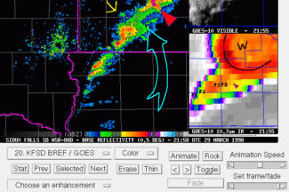
ProbSevere
ProbSevere is a statistical model that predicts the likelihood of a storm producing severe weather within the next 60 minutes.
Contact:
John Cintineo, NOAA, Lena Heuscher-StewartCategories:
Hazards, Modeling and data assimilationSponsors:
NOAA -
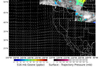
Real-time Air Quality Modeling System RAQMS
The Real-time Air Quality Modeling System (RAQMS) is an online system for assimilating and forecasting global, ambient chemicals, and aerosols in the stratosphere and troposphere.
Website:
http://raqms-ops.ssec.wisc.edu/Contact:
Brad Pierce (PI)Categories:
Atmospheric Composition, Modeling and data assimilation -

Reliable Automated Instrumentation Network (RAIN)
SSEC, in collaboration with other departments on campus, maintains a Reliable Automated Instrumentation Network (RAIN) for research purposes. On the AOSS building rooftop, instruments measure atmospheric parameters, while North, South, East, and West facing cameras record weather events. A buoy on Lake Mendota monitors lake quality and weather conditions.
Website:
http://metobs.ssec.wisc.eduContact:
Tim Wagner, Jonathan Thom, David Hoese, Fred BestCategories:
Instruments, SurfaceSponsors:
NOAA -
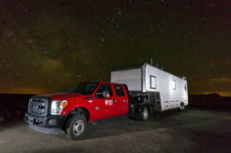
SSEC Portable Atmospheric Research Center (SPARC)
The SSEC Portable Atmospheric Research Center (SPARC) is a vehicle outfitted with a suite of instruments to make ground-based measurements used for studying the atmosphere during field campaigns across the country. The SPARC is part of the U.S. National Science Foundation’s (NSF) Facilities for Atmospheric Research and Education (FARE) Community Instruments and Facilities (CIF) program.
Website:
https://www.ssec.wisc.edu/sparc/Contact:
Jonathan Gero (PI), Tim WagnerCategories:
Instruments, Surface -
Satellite Hydrology and Meteorology (SHyMet)
Researchers develop online courses for NWS forecasters to learn more about polar orbiting and geostationary satellite data and products.
Contact:
Scott BachmeierCategories:
TrainingSponsors:
NOAA -
Satellite Information Familiarization Tool (SIFT)
SIFT is a user-friendly visualization system developed to train meteorologists to use satellite imagery.
Website:
http://sift.ssec.wisc.edu/Contact:
Tim WagnerCategories:
TrainingSponsors:
NOAA -

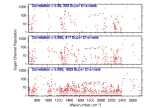
Satellite Radiance and Sounder Data Fusion Science Projects
This project fuses low earth orbit and geostationary imager and sounder products to construct radiances and hyperspectral sounder products at improved spatial and temporal resolution for weather monitoring and forecasting operations.
Contact:
Elisabeth Weisz, Paul MenzelCategories:
Geostationary Satellites, Low-Earth Orbiting SatellitesSponsors:
NOAA -
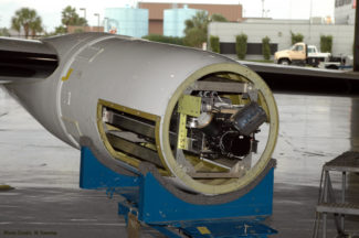
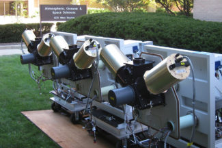
Scanning High-resolution Interferometer Sounder (S-HIS)
Designed and built at SSEC, the Scanning High-resolution Interferometer Sounder (S-HIS) measures temperature and water vapor profiles. Data gathered in field experiments is used to advance our understanding of the Earth’s atmosphere, support calibration and validation of current satellite sensors, and help to develop future weather satellite sounders.
Website:
https://shis.ssec.wisc.edu/Contact:
Joe Taylor (PI)Categories:
Instruments -
Science Investigator-led Processing System (SIPS)
The Atmosphere Science Investigator-led Processing System (SIPS) processes VIIRS data from the Suomi NPP satellite to produce Level 2 cloud and aerosol products, including cloud height, cloud phase, cloud properties, and aerosol optical thickness.
Website:
http://sips.ssec.wisc.edu/Contact:
Liam GumleyCategories:
Visualization and softwareSponsors:
NASA -
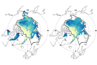
Sea Ice Products
Using satellite data, NOAA and CIMSS scientists are studying sea ice trends in the polar regions.
Contact:
Yinghui Liu, NOAA STAR (PI), Xuanji Wang, Jeff KeyCategories:
Polar Research, SurfaceSponsors:
NOAA -
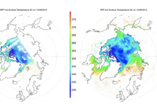
Snow Cover/Ice Surface Temperature
This cryosphere research involves algorithm development to identify ice and snow cover and estimate ice concentration and ice surface temperature over water surfaces using information from satellite observations and other products.
Contact:
Yinghui Liu, NOAA STAR (PI), Xuanji Wang, Jeff KeyCategories:
Polar Research, SurfaceSponsors:
NOAA -
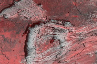
Snowfall Microphysics + Radar Observatory (lake effect snow)
The snowfall microphysics + radar observatory research program collects and catalogs sustained snowflake particle size distribution and habit type measurements to understand how microphysical details affect radar signatures.
Contact:
Norm Wood, Tristan L’EcuyerCategories:
SurfaceSponsors:
NASA -
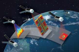
Time-Resolved Observations of Precipitation structure and storm Intensity with a Constellation of Smallsats (TROPICS)
The Time-Resolved Observations of Precipitation structure and storm Intensity with a Constellation of Smallsats (TROPICS) project employs 4 nanosatellites called CubeSats to study tropical cyclones via rapid sampling microwave observations. The CIMSS Tropical Cyclone research group is charged with developing methods to estimate storm intensity from this data.
Website:
https://tropics.ssec.wisc.edu/Contact:
Derrick HerndonCategories:
Low-Earth Orbiting Satellites, Tropical CyclonesSponsors:
NASA -
Tropical Cyclone ML/AI Research (TC ML/AI)
CIMSS scientists have been investigating how they can use AI to improve short-term forecasts of hurricanes, and in particular their intensity.
Contact:
Tony Wimmers, Sarah Griffin -
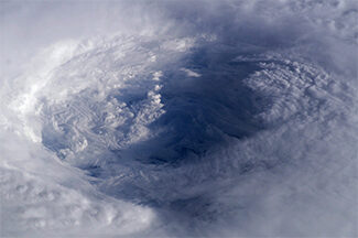
Tropical Cyclone Research
The CIMSS Tropical Cyclone Research group develops satellite-derived products to improve the analysis and prediction of tropical cyclones, leading to a better understanding of storm behavior and more timely and effective warnings.
Website:
http://tropic.ssec.wisc.edu/Contact:
Derrick Herndon, Tony WimmersCategories:
Hazards, Tropical Cyclones -
Virtual Institute for Satellite Integration Training (VISIT)
The Virtual Institute for Satellite Integration Training (VISIT) program trains National Weather Service forecasters using distance education techniques to accelerate the transfer of satellite-based atmospheric research into operations. This includes VISITview, a teletraining and real-time collaboration tool developed at SSEC, along with courses developed and led by SSEC scientists.
Website:
http://www.ssec.wisc.edu/visit/Contact:
Tim WagnerCategories:
TrainingSponsors:
NOAA -
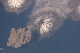
Volcanic Cloud Monitoring
NOAA and CIMSS scientists have developed tools to detect volcanic ash and dust clouds using data from geostationary and polar-orbiting satellites—information that is used to issue volcanic ash advisories to the aviation community.
Website:
http://volcano.ssec.wisc.edu/Categories:
Atmospheric Composition, HazardsSponsors:
NOAA
-
▴ ▾ Absolute Radiance Interferometer for the CLARREO Pathfinder (ARI)
The Absolute Radiance Interferometer is an instrument developed by SSEC scientists and engineers that is capable of measuring infrared radiation in Earth’s atmosphere to a high-degree of accuracy. Roughly the size of a small freezer, the ARI is designed to be flight ready for future satellite missions.
Contact:
Hank Revercomb, Joe TaylorTags:
Geostationary Satellites -
▴ ▾ Atmospheric Emitted Radiance Interferometer (AERI)
A ground-based instrument developed by SSEC, the Atmospheric Emitted Radiance Interferometer (AERI) measures temperature, water vapor, and trace gases in the boundary layer.
Website:
http://www.ssec.wisc.edu/aeri/Contact:
Jonathan Gero (PI), Denny HackelTags:
Instruments, CloudsSponsors:
DOE -
▴ ▾ Atmospheric Infrared Sounder (AIRS)
SSEC scientists have helped calibrate the Atmospheric Infrared Sounder (AIRS) onboard the Aqua satellite and currently validate its data, develop algorithms to make the data useful, and write software for processing the data from direct broadcast facilities.
Contact:
Allen Huang (PI)Sponsors:
NASA -
▴ ▾ Atmospheric Motion Vector Research
SSEC is known for its pioneering work with atmospheric motion vectors (AMVs) to track wind patterns by analyzing numerous sets of satellite images. These include AMVs from geostationary (GEO) satellite observations over mid-latitudes and the tropics and AMVs from low earth-orbiting (LEO) satellites over polar regions.
Contact:
Dave Santek, Chris VeldenTags:
CloudsSponsors:
NOAA -
▴ ▾ CIMSS GOES/GOES-R LAP Validation Tool
This tool validates operational GOES-R Advanced Baseline Imager (ABI) Legacy Atmospheric profile (LAP) retrieval products, focusing on parameters such as TPW, atmospheric stability indices, temperature/water vapor profiles.
Website:
https://soundingval.ssec.wisc.edu/Contact:
Zhenglong Li (PI)Tags:
Geostationary SatellitesSponsors:
NOAA -
▴ ▾ Clouds from AVHRR Extended (CLAVR-x)
The Clouds from AVHRR extended (CLAVR-x) system processes cloud data for NOAA operations using the AVHRR instrument on the NOAA-POES and EUMETSAT-METOP series of polar orbiting satellites.
Website:
https://www.ssec.wisc.edu/clavrx/Contact:
Andrew Heidinger, NOAA, Michael Foster (PI)Tags:
CloudsSponsors:
NOAA -
▴ ▾ Community Satellite Processing Package (CSPP) Geo
The Community Satellite Processing Package (CSPP) Geo is free open source software developed to support Direct Broadcast (DB) users with processing geostationary satellite data to generate geophysical products.
Website:
http://cimss.ssec.wisc.edu/csppgeo/Contact:
Graeme Martin, Ray GarciaSponsors:
NOAA -
▴ ▾ Community Satellite Processing Package (CSPP) Leo
The Community Satellite Processing Package (CSPP) Leo is free open source software developed to support Direct Broadcast (DB) users with processing polar-orbiting satellite data for regional products and applications.
Website:
http://cimss.ssec.wisc.edu/cspp/Contact:
Liam Gumley (PI), Kathy Strabala -
▴ ▾ Cross-track Infrared Sounder (CrIS)
In preparation for JPSS-1 and for the current Suomi NPP, SSEC and CIMSS scientists are integrally involved in the pre-launch design and testing, as well as post-launch plans to assess the quality of the Cross-track Infrared Sounder (CrIS) data.
Contact:
David Tobin, Joe TaylorSponsors:
NOAA -
▴ ▾ Data Assimilation
SSEC scientists conduct research to improve satellite data assimilation techniques in operational weather forecast models.
Contact:
Jason OtkinSponsors:
NOAA -
▴ ▾ Educational Software
Learn more about weather and climate through these educational applets.
Website:
https://cimss.ssec.wisc.edu/wxfest/Contact:
Tim Wagner -
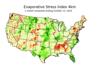
▴ ▾ Evaporative Stress Index (ESI)
The Evaporative Stress Index (ESI) uses satellite data to track changes in the amount of water vapor released by vegetation via transpiration. Monitoring the ESI could provide early warning of developing drought.
Website:
http://hrsl.arsusda.gov/drought/Contact:
Jason Otkin (PI)Tags:
HazardsSponsors:
NOAA -
▴ ▾ Future Weather Satellite System Design and Science Studies
Scientists will partner with NOAA to accelerate the operational readiness of new observing systems and technology in ways that reduce cost and risk.
Contact:
Brad Pierce, Tim SchmitSponsors:
NOAA -
▴ ▾ GOES Satellite Verification System for the HRRR Model
SSEC scientists have developed an automated ranking method to quickly assess the accuracy of High Resolution Rapid Refresh (HRRR) model forecasts through comparison of observed and simulated Geostationary Operational Environmental Satellite (GOES) infrared brightness temperatures.
Website:
http://cimss.ssec.wisc.edu/hrrrval/Contact:
Jason Otkin (PI)Sponsors:
NOAA -
▴ ▾ GOES-R series activities at SSEC/CIMSS
From helping to formulate the Advanced Baseline Imager, to developing algorithms and advanced products, SSEC and CIMSS scientists are now using the more timely and detailed observations of GOES-R to enhance our research of Earth’s atmosphere and weather.
Website:
https://cimss.ssec.wisc.edu/goes-r/Contact:
Mathew Gunshor, Tim SchmitTags:
Geostationary SatellitesSponsors:
NOAA -
▴ ▾ Geostationary Extended Observations (GeoXO)
Scientists will collaborate with NOAA to prepare for the next generation satellite systems beyond GOES-R, including looking at new orbits, sensors, satellite options, as well as commercial partnerships.
Contact:
Brad Pierce, Tristan L'EcuyerTags:
Geostationary SatellitesSponsors:
NOAA -
▴ ▾ Geostationary Hyperspectral IR Sounder
The nation's current GOES-R series do not have a geostationary (GEO) hyperspectral IR sounder, while several international agencies have or are developing such a capability. The GEO hyperspectral IR sounders will greatly enhance the current forecast capability by providing critical high temporal resolution sounding information.
Contact:
Zhenglong Li, Tim SchmitTags:
Geostationary SatellitesSponsors:
NOAA -
▴ ▾ Hazardous Weather Testbed (HWT)
The Hazardous Weather Testbed provides a platform to test new research and develop improved methods and technologies that support the advancement of severe weather forecasts and warnings.
Contact:
Tim WagnerSponsors:
NOAA -
▴ ▾ Hazus-MH Based Project Support
Hazus-MH, created in partnership with the Federal Emergency Management Administration (FEMA), uses Geographic Information Systems (GIS) technology to estimate physical, economic, and social impacts of disasters such as earthquakes, hurricane winds, and floods.
Contact:
Shane Hubbard (PI)Sponsors:
FEMA -
▴ ▾ High Performance Computing Data Processing: NOAA ASSISTT Enterprise
Researchers will work with NOAA to support the transition of algorithms to operations.
Contact:
Ray Garcia, Graeme MartinSponsors:
NOAA -
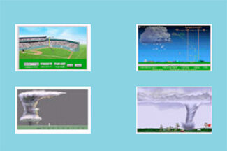
▴ ▾ High resolution modeling (simulation and visualization of thunderstorms, tornadoes, downbursts)
Using ultra-high resolution simulations of supercell thunderstorms, as well as state-of-the-art visualization and analysis software, researchers are studying how these storms evolve and produce tornadoes and downbursts.
Website:
http://orf.media/Contact:
Leigh Orf (PI)Sponsors:
NSF -
▴ ▾ Hyper-spectral Viewer for Development of Research Applications (HYDRA)
HYDRA software allows for the analysis and visualization of multispectral and hyperspectral data acquired from weather satellites.
Website:
http://www.ssec.wisc.edu/hydra/Contact:
Thomas RinkSponsors:
NOAA -
▴ ▾ Imager and Sounder Fusion
CIMSS scientists have been investigating imager data fusion with sounder data and products to construct spectral bands and sounding products at imager spatial (and temporal for GEO) resolution.
Contact:
Elisabeth Weisz -
▴ ▾ Infrared Atmospheric Sounding Interferometer (IASI)
To validate the measurements and to conduct studies, SSEC researchers compare data from the Infrared Atmospheric Sounding Interferometer (IASI) on the European MetOp satellite with data from other sounders, such as the Atmospheric Infrared Sounder (AIRS) and the Cross-track Infrared Sounder (CrIS).
Contact:
David Tobin, Joe TaylorSponsors:
NASA -
▴ ▾ Infusing satellite Data into Environmental Applications - International (IDEA-I)
The Infusing satellite Data into Environmental Applications - International (IDEA-I) develops satellite-based aerosol forecasting, visualization, and data synthesis tools for use by the international air quality forecasting community.
Contact:
Brad Pierce (PI)Tags:
Atmospheric Composition -
▴ ▾ International Satellite Training
Scientists will collaborate with Taiwan Central Weather Bureau scientists to develop products for the Himawari satellite based on CIMSS’s product development experience for GOES-16 and -17.
Contact:
Mike FosterTags:
Geostationary Satellites, TrainingSponsors:
NOAA -
-
▴ ▾ Leo/Geo Fusion Project
This project fuses low earth orbit and geostationary imager and sounder products to construct radiances and hyperspectral sounder products at improved spatial and temporal resolution for weather monitoring and forecasting operations.
Contact:
Elisabeth WeiszSponsors:
NOAA -
▴ ▾ MODIS-VIIRS Continuity Cloud Products
The NASA MODerate-resolution Imaging Spectroradiometer (MODIS) and Suomi National Polar-Orbiting Partnership (SNPP) Visible Infrared Imaging Radiometer Suite (VIIRS) cloud products represent an effort to establish a continuous, multi-decadal climate data record for clouds.
Contact:
Mike FosterTags:
CloudsSponsors:
NOAA -
▴ ▾ Man Computer Interactive Data Access System (McIDAS-V)
McIDAS-V is a free, Java-based, open-source software package that allows for visualization and analysis of data retrieved from weather satellites.
Contact:
Dave Santek, Becky SchafferSponsors:
NOAA -
▴ ▾ Mesoscale Winds
We are estimating wind vectors by applying an optical flow technique to one-minute imagery from GOES-16.
Contact:
Robert Rabin (PI)Tags:
Geostationary Satellites, HazardsSponsors:
NOAA -
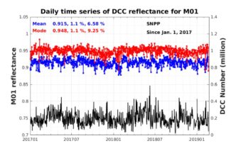
▴ ▾ Monitoring VIIRS RSBs using CrIS based DCC
This project uses CrIS detected deep convective clouds (DCCs) to monitor the radiometric stabilities of the VIIRS reflective solar bands (RSBs) of SNPP and NOAA-20 as part of the VIIRS SDR calibration efforts.
Contact:
Zhenglong LiSponsors:
NOAA -
▴ ▾ Morphed Integrated Microwave Imagery at CIMSS - Total Precipitable Water (MIMIC-TPW)
MIMIC-TPW is a technique that combines microwave observations from polar orbiting satellites to create near-seamless hourly imagery of global total precipitable water (TPW).
Contact:
Tony Wimmers, Jonathan GeroSponsors:
NOAA -
▴ ▾ NOAA Satellite Proving Ground Global Flood Website
Through a collaboration with scientists at George Mason University, researchers at SSEC and CIMSS routinely generate flood detection products from a suite of satellites including polar (SNPP & NOAA-20) and geostationary (GOES-East, GOES-West, and AHI-8) satellites in near realtime.
Contact:
Jay HoffmanSponsors:
NOAA -
▴ ▾ Nearcasting
Utilizing infrared water vapor data from GOES, Nearcasting is used to predict severe weather outbursts one to six hours in advance. This technique fills the gap between radar nowcasts, which predict weather from the zero to one-hour range, and NWP forecasting models which predict weather more than eight hours in advance.
Contact:
Ralph Petersen, Lee CronceTags:
HazardsSponsors:
NOAA -
▴ ▾ Pathfinder Atmospheres - Extended (PATMOS-x)
The Pathfinder Atmospheres - Extended (PATMOS-x) project team derives atmospheric and surface records from NOAA's Advanced Very High Resolution Radiometer (AVHRR) data over the last 25 years.
Website:
http://cimss.ssec.wisc.edu/patmosx/Contact:
Andrew Heidinger, NOAA, Mike FosterTags:
CloudsSponsors:
NOAA -
▴ ▾ Polar Winds
-
▴ ▾ ProbSevere
ProbSevere is a statistical model that predicts the likelihood of a storm producing severe weather within the next 60 minutes.
Contact:
Michael Pavolonis, NOAATags:
HazardsSponsors:
NOAA -
▴ ▾ Real-time Air Quality Modeling System RAQMS
The Real-time Air Quality Modeling System (RAQMS) is an online system for assimilating and forecasting global, ambient chemicals, and aerosols in the stratosphere and troposphere.
Website:
http://raqms-ops.ssec.wisc.edu/Contact:
Brad Pierce (PI) -
▴ ▾ Reliable Automated Instrumentation Network (RAIN)
SSEC, in collaboration with other departments on campus, maintains a Reliable Automated Instrumentation Network (RAIN) for research purposes. On the AOSS building rooftop, instruments measure atmospheric parameters, while North, South, East, and West facing cameras record weather events. A buoy on Lake Mendota monitors lake quality and weather conditions.
Website:
http://metobs.ssec.wisc.eduContact:
Tim Wagner, Jonathan Thom, David Hoese, Fred BestTags:
InstrumentsSponsors:
NOAA -
▴ ▾ SSEC Portable Atmospheric Research Center (SPARC)
The SSEC Portable Atmospheric Research Center (SPARC) is a vehicle outfitted with a suite of instruments to make ground-based measurements used for studying the atmosphere during field campaigns across the country. The SPARC is part of the U.S. National Science Foundation’s (NSF) Facilities for Atmospheric Research and Education (FARE) Community Instruments and Facilities (CIF) program.
Website:
https://www.ssec.wisc.edu/sparc/Contact:
Jonathan Gero (PI), Tim WagnerTags:
Instruments -
▴ ▾ Satellite Data Assimilation for Tropical storms (SDAT)
The Satellite Data Assimilation for Tropical storm is a near realtime experimental data assimilation system that uses conventional and satellite data to demonstrate the use of Joint Polar Satellite System sounder observations for improving tropical cyclone track and intensity forecasts.
Website:
http://cimss.ssec.wisc.edu/sdat/Contact:
Jinlong LiSponsors:
NOAA -
▴ ▾ Satellite Hydrology and Meteorology (SHyMet)
Researchers develop online courses for NWS forecasters to learn more about polar orbiting and geostationary satellite data and products.
Contact:
Scott BachmeierTags:
Sponsors:
NOAA -
▴ ▾ Satellite Information Familiarization Tool (SIFT)
SIFT is a user-friendly visualization system developed to train meteorologists to use satellite imagery.
Website:
http://sift.ssec.wisc.edu/Contact:
Tim WagnerTags:
TrainingSponsors:
NOAA -
▴ ▾ Scanning High-resolution Interferometer Sounder (S-HIS)
Designed and built at SSEC, the Scanning High-resolution Interferometer Sounder (S-HIS) measures temperature and water vapor profiles. Data gathered in field experiments is used to advance our understanding of the Earth's atmosphere, support calibration and validation of current satellite sensors, and help to develop future weather satellite sounders.
Website:
https://shis.ssec.wisc.edu/Contact:
Joe Taylor (PI)Tags:
InstrumentsSponsors:
NASA -
▴ ▾ Science Investigator-led Processing System (SIPS)
The Atmosphere Science Investigator-led Processing System (SIPS) processes VIIRS data from the Suomi NPP satellite to produce Level 2 cloud and aerosol products, including cloud height, cloud phase, cloud properties, and aerosol optical thickness.
Website:
http://sips.ssec.wisc.edu/Contact:
Liam GumleySponsors:
NASA -
▴ ▾ Sea Ice Products
Using satellite data, NOAA and CIMSS scientists are studying sea ice trends in the polar regions.
Contact:
Yinghui Liu, NOAA STAR (PI)Tags:
SurfaceSponsors:
NOAA -
▴ ▾ Snow Cover/Ice Surface Temperature
This cryosphere research involves algorithm development to identify ice and snow cover and estimate ice concentration and ice surface temperature over water surfaces using information from satellite observations and other products.
Contact:
Yinghui Liu, NOAA STAR (PI)Tags:
SurfaceSponsors:
NOAA -
▴ ▾ Snowfall Microphysics + Radar Observatory (lake effect snow)
The snowfall microphysics + radar observatory research program collects and catalogs sustained snowflake particle size distribution and habit type measurements to understand how microphysical details affect radar signatures.
Contact:
Norm Wood, Tristan L'Ecuyer, Claire PettersenTags:
InstrumentsSponsors:
NASA -
▴ ▾ Time-Resolved Observations of Precipitation structure and storm Intensity with a Constellation of Smallsats (TROPICS)
The Time-Resolved Observations of Precipitation structure and storm Intensity with a Constellation of Smallsats (TROPICS) investigation will develop and launch a constellation of nanosatellites called CubeSats to study the development of tropical cyclones through rapid sampling of the atmosphere.
Contact:
Chris Velden, Liam GumleySponsors:
NASA -
▴ ▾ Tropical Cyclone Artificial Intelligence (TC AI)
CIMSS scientists have been investigating how they can use AI to improve short-term forecasts of hurricanes, and in particular their intensity.
Contact:
Tony WimmersSponsors:
NOAA -
▴ ▾ Tropical Cyclone Research
The CIMSS Tropical Cyclone Research group develops satellite-derived products to improve the analysis and prediction of tropical storms, leading to more accurate tropical cyclone forecasts and more timely and effective warnings.
Website:
http://tropic.ssec.wisc.edu/Contact:
Chris Velden (PI), Derrick HerndonTags:
Tropical Cyclones -
▴ ▾ Virtual Institute for Satellite Integration Training (VISIT)
The Virtual Institute for Satellite Integration Training (VISIT) program trains National Weather Service forecasters using distance education techniques to accelerate the transfer of satellite-based atmospheric research into operations. This includes VISITview, a teletraining and real-time collaboration tool developed at SSEC, along with courses developed and led by SSEC scientists.
Website:
http://www.ssec.wisc.edu/visit/Contact:
Tim WagnerTags:
TrainingSponsors:
NOAA -
▴ ▾ Volcanic Cloud Monitoring
NOAA and CIMSS scientists have developed tools to detect volcanic ash and dust clouds using data from geostationary and polar-orbiting satellites—information that is used to issue volcanic ash advisories to the aviation community.
Website:
http://volcano.ssec.wisc.edu/Tags:
Atmospheric CompositionSponsors:
NOAA