Hazards
Research Categories | All Research Projects
Saving lives and protecting property are at the core of our mission and research. We develop satellite data products and instruments that lead to better forecasts and warning systems for severe weather, fire hazards, hurricanes, floods, and aviation decision support hazards.
-
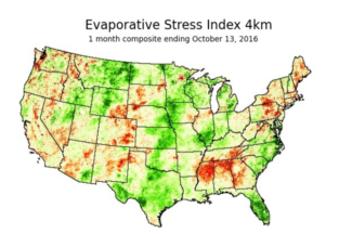
Drought Research
Our work focuses on using satellite observations and model reanalysis datasets to develop new tools to detect, monitor, and forecast rapidly intensifying flash drought events. We also work with decision-makers to better understand and address their drought information needs.
Contact:
Jason Otkin (PI)Categories:
HazardsSponsors:
NOAA -
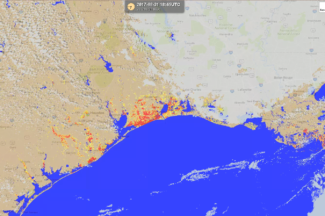
Flood Research
Through a collaboration with scientists at George Mason University, researchers at SSEC and CIMSS routinely generate flood detection products from a suite of satellites including polar (SNPP & NOAA-20) and geostationary (GOES-East, GOES-West, and AHI-8) satellites in near realtime.
Contact:
Jay HoffmanCategories:
Hazards, Visualization and softwareSponsors:
NOAA -
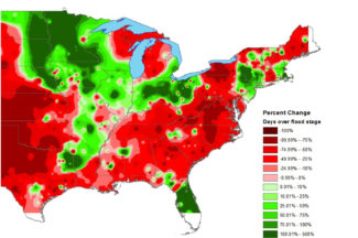
Hazus-MH Based Project Support
Hazus-MH, created in partnership with the Federal Emergency Management Administration (FEMA), uses Geographic Information Systems (GIS) technology to estimate physical, economic, and social impacts of disasters such as earthquakes, hurricane winds, and floods.
Contact:
Shane Hubbard (PI)Categories:
Hazards, Modeling and data assimilationSponsors:
FEMA -

Mesoscale Winds
We are estimating wind vectors by applying an optical flow technique to one-minute imagery from GOES-16.
Contact:
Dave StettnerCategories:
Geostationary Satellites, HazardsSponsors:
NOAA -
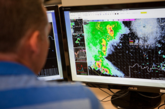
NOAA Weather Satellite Proving Ground Testbeds
The Hazardous Weather Testbed provides a platform to test new research and develop improved methods and technologies that support the advancement of severe weather forecasts and warnings.
Contact:
Tim Wagner, Wayne FeltzSponsors:
NOAA -
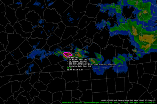
ProbSevere
ProbSevere is a statistical model that predicts the likelihood of a storm producing severe weather within the next 60 minutes.
Contact:
John Cintineo, NOAA, Lena Heuscher-StewartCategories:
Hazards, Modeling and data assimilationSponsors:
NOAA -
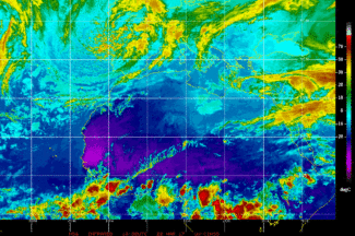
Tropical Cyclone Research
The CIMSS Tropical Cyclone Research group develops satellite-derived products to improve the analysis and prediction of tropical cyclones, leading to a better understanding of storm behavior and more timely and effective warnings.
Website:
http://tropic.ssec.wisc.edu/Contact:
Derrick Herndon, Tony WimmersCategories:
Hazards, Tropical Cyclones -
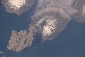
Volcanic Cloud Monitoring
NOAA and CIMSS scientists have developed tools to detect volcanic ash and dust clouds using data from geostationary and polar-orbiting satellites—information that is used to issue volcanic ash advisories to the aviation community.
Website:
http://volcano.ssec.wisc.edu/Categories:
Atmospheric Composition, HazardsSponsors:
NOAA