CRAS Imagery in D-2DInstructions for AWIPS InstallationSpace Science and Engineering Center
|
|
| Project members: Robert Aune (NESDIS/NOAA), Scott Bachmeier, Russ Dengel, Jordan Gerth, Scott Lindstrom, Jerrold Robaidek, Kathy Strabala, Steve Wanzong | |
Phase One (Flagship)
Schedule
- July 5, 2006: Phase initiated
- July 27, 2006: Assure data feed to CRH approved, running
- August 16, 2006: Release of scripts for internal review
- August 21, 2006: Final preparation of installation scripts
- August 24, 2006: Test forecast infrared images created
- August 29, 2006: Infrared image testing completed
- August 30, 2006: Milwaukee/Sullivan Installation
Install team: Jordan Gerth (SSEC), Kim Licitar (NWS) [See Photographs]- August 30, 2006: Internal release of Version 1.0
- September 7, 2006: Water vapor image testing
- September 11, 2006: Official release of Version 1.0
- September 25, 2006: Version 1.0 testing finished; expansion to 72 hours
- October 26, 2006: Version 1.1 released to fix localPurgeInfo.txt file
- December 12, 2006: Graphical Forecast Editor (GFE) SmartTool Capability
- December 21, 2006: Documentation update for OB7 changes
- January 26, 2007: Addition of updates and outages online mailing list
- April 14, 2007: Application of model initialization time to images
- July 7, 2010: CRAS model output is now available in GRIB2 format
Offices are strongly encouraged to register with the Local Applications Database (LAD).
The Space Science and Engineering is not staffed around the clock. Consequently, data outages and processing issues may result. These images should be considered non-operational.
Any site which wishes to download this package should be aware that the files and scripts are considered final, but the images pulled from the LDM are non-operational. Weather Forecast Offices which wish to be test sites for future upgrades and phases should contact Jordan Gerth.
- Files and Scripts [eastConus] (CRASpack.tar.gz, 9928 bytes)
- Files and Scripts [westConus] (CRASpackWEST.tar.gz, 9938 bytes)
- Documentation (CRASinstall.pdf, via FTP server)
Known Pitfalls
- The localization install script assumes local files in /data/fxa/customFiles have the WFO identifier as the first three characters of the file name (LLL-).
For sites ingesting MODIS imagery
- Conflict Notice - Sep 8 (Memo_Aug21.pdf, 26453 bytes)
Further Reading
- Detailed Model Specifications (Aune, 2008)
- Interpreting the CRAS45 (Aune, 2009)
- PowerPoint Presentation for Internet Explorer (Aune, 2006)
- Validation CRAS Forecast with GOES (Harrington, 2006)
Installation and Application
The CRAS data feed is currently served to offices solely in the Central Region, Eastern Region, and Western Region.
Are you in the Southern Region, Alaska Region, or Pacific Region, and want CRAS? Contact Jordan Gerth.
The following sites successfully installed CRAS imagery in AWIPS in 2006:
- Milwaukee/Sullivan, Wisconsin (MKX) - Phase One (8/30/2006) - MKX Area Forecast Discussions mentioning CRAS
- Riverton, Wyoming (RIW) - Phase One (9/13/2006) - RIW Area Forecast Discussions mentioning CRAS
- Indianapolis, Indiana (IND) - Phase One (12/20/2006) - IND Area Forecast Discussions mentioning CRAS
The following sites successfully installed CRAS imagery in AWIPS since then:
- Aberdeen, South Dakota (ABR) - Phase One (2007) - ABR Area Forecast Discussions mentioning CRAS
- Boulder, Colorado (BOU) - Phase One (2008)
- Burlington, Vermont (BTV) - Phase One (2008) - BTV Area Forecast Discussions mentioning CRAS
- Fargo, North Dakota (FGF) - Phase One (2008)
- Kansas City, Missouri (EAX) - Phase One (2008) - EAX Area Forecast Discussions mentioning CRAS
- La Crosse, Wisconsin (ARX) - Phase One (2007)
- Minneapolis, Minnesota (MPX) - Phase One (2008) - MPX Area Forecast Discussions mentioning CRAS
- Northern Indiana (IWX) - Phase One (2008) - IWX Area Forecast Discussions mentioning CRAS
- Nashville, Tennessee (OHX) - Phase One (2007)
- Rapid City, South Dakota (UNR) - Phase One (2008)
- Springfield, Missouri (SGF) - Phase One (2007)
The Aberdeen National Weather Service Forecast Office (KABR) explains how they use the CRAS in this newsletter article. See page 5.
A map of the National Weather Service forecast offices participating in the CRAS in AWIPS project is available. There are currently 25 offices receiving CRAS imagery from the Cooperative Institute for Meteorological Satellite Studies (CIMSS), plus four distribution nodes.
If your office is receiving CRAS in AWIPS from CIMSS, and is not included on this list, please contact Jordan Gerth.
The following sites have planned to install CRAS imagery in AWIPS:
- None currently
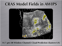
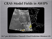
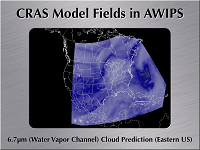
Screenshots
Courtesy of Scott Bachmeier (contact)
VISITview Presentation
Courtesy of Scott Lindstrom (contact)
- VISIT Student Guide: CRAS Forecast Imagery in AWIPS
- Instructions for Installing the "CRAS Forecast Imagery in AWIPS" Session
Related Links


