MODIS Imagery in D-2DInstructions for AWIPS InstallationSpace Science and Engineering Center
|
|
| Project members: Scott Bachmeier, Russ Dengel, Jordan Gerth, Scott Lindstrom, Jerrold Robaidek, Kathy Strabala, Steve Wanzong | |
Announcements
Like MODIS? Want more data from polar-orbiting satellites? AVHRR imagery and products are now available.
The orbit itinerary viewer and color tables for the MODIS stability products are now available. See Phase One (East) and Phase Three (West) below.
Did you miss us at the 16th Annual Great Lakes Operational Meteorology Workshop? The slides from our presentation are available online.
Find Scott Bachmeier's color tables for satellite imagery below.
Look at the list of the latest forecast offices to join the MODIS in AWIPS project below. The number of AFDs mentioning MODIS continues to grow.
Phase One (Flagship)
No previous installation required; for Eastern, eastern Southern, and eastern Central Region Weather Forecast Offices only
Imagery and products available to offices in the eastern United States under this phase include:
- Visible - Band 1 (1 km)
- Snow/Ice - Band 7 (1 km)
- Cirrus - Band 26 (1 km)
- 3.7μm - Band 20 (1 km)
- Water Vapor - Band 27 (1 km)
- IR Window - Band 31 (1 km)
- 11μm - 3.7μm Product (1 km)
- Land Sfc Temperature (1 km)
Added July 28, 2008- Normalized Difference Vegetation Index (1 km)
Added July 28, 2008- Land Surface Temperature Summer (1 km)
Added July 28, 2008
- Total Precipitable Water (4 km)
- Cloud Phase (4 km)
- Cloud Top Temperature (4 km)
Activated but Untested
- Lifted Index (4 km)
- Total Totals (4 km)
- K Index (4 km)
Schedule
- June 5, 2006: Phase initiated
- June 7, 2006: Release of scripts for internal review
- June 15, 2006: Add screenshots below
- June 23, 2006: Assure data feed to CRH approved, running
- June 27, 2006: Final preparation of installation scripts
- June 30, 2006: Milwaukee/Sullivan Installation - Part I
- July 7, 2006: Milwaukee/Sullivan Installation - Part II
Install team: Jordan Gerth (SSEC), Steve Wanzong (SSEC), Kim Licitar (NWS)
Screen Captures; Photographs- July 10, 2006: Official release of Version 1.0
- July 17, 2006: Version 1.0 testing finished
- August 1, 2006: Version 1.1 released (Mandatory)
- August 4, 2006: Deployment deadline for Version 1.1
- September 8, 2006: Version 1.11 upgrade released (Optional)
- September 8, 2006: Special memo about CRAS (V1.0,1.1 only)
- October 26, 2006: Version 1.13 upgrade released (Optional)
- October 26, 2006: Version 1.2 released (Mandatory)
- October 27, 2006: Deployment deadline for Version 1.2
- December 21, 2006: Documentation update for OB7 changes
- July 24, 2008: Addition of three new fire weather products to data feed
- July 25, 2008: Proposed addition of three new stability products to data feed
- July 28, 2008: Version 1.50 released (Optional)
Offices are strongly encouraged to register with the Local Applications Database (LAD).
The Space Science and Engineering is not staffed around the clock. Consequently, data outages and processing issues may result. These images should be considered non-operational.
Any site which wishes to download this package should be aware that the files and scripts are considered final, but the images pulled from the LDM are non-operational. Weather Forecast Offices which wish to be test sites for future upgrades and phases should contact Jordan Gerth.
Note: Mandatory upgrades only have one digit after the decimal.
Full Installation (1.50) Most Recent Upgrade (1.2 to 1.50)
- Files and Scripts (MODISpack.tar.gz, via FTP Server)
- Documentation (MODISinstall.pdf, via FTP Server)
Add the stability products to 1.50
- Files and Scripts (MODISpack-u.tar.gz, via FTP Server)
- Documentation (MODISupgrade.pdf, via FTP Server)
- Append to (XYZ-)localImageStyle.txt
- Add the new color tables to customColorMaps.nc
- Update (XYZ-)localDepictKeys.txt and localize with "mainScript.csh f -tables"
Optional — You can have GUARDIAN send an announcement when a new pass has arrived with these instructions.
Previous Upgrades (up to 1.2) Orbit Itinerary Viewer
- Upgrade Notice - Aug 3 (FeedChange_Aug3.pdf, 166480 bytes)
- Processor Upgrade (processMODIS.pl.gz, 1343 bytes)
- infoPages Upgrade - East (html-add-1.1-east.tar.gz, 2455 bytes)
- Upgrade Notice - Sep 8 (MACPChange_Sep8.pdf, 108693 bytes)
- Conflict Notice - Sep 8 (Memo_Aug21.pdf, 26453 bytes)
- Upgrade Notice (1.13) - Oct 26 (NameChange_Oct26.pdf, 109219 bytes)
- Upgrade Notice (1.2) - Oct 26 (CTTSEChange_Oct26.pdf, 190429 bytes)
- Color Table Upgrade - Oct 26 (manage-ct.tar, 51200 bytes)
- Color Tables for Satellite Imagery (sbct.tar.gz, via FTP Server)
- Installation Bundle with Instructions Inside (moi.tgz, via FTP Server)
Known Pitfalls
- The localization install script assumes local files in /data/fxa/customFiles have the WFO identifier as the first three characters of the file name (LLL-).
- WFO La Crosse reported that the MODIS imagery was blocking other products from being ingested via the LDM. It was recommended that they expand the size of their ldm.pq to 250M and limit ingestion to .*_AWIPS_MODIS_EAST_.* images only in their ldmd.conf.
- If you experience trouble with the notification server, especially during an upgrade, try running the mainScript.csh with an 'f' to force the localization and update all necessary files, then restart the notification server.
- Doris Hood from Spaceflight Meteorology Group reported that GOES imagery was loading into certain MODIS directories. The National Control Facility recommended making some changes to the LLL-localDataKeys.txt file such that the third pipe-delimited column of all MODIS entries contains a value '3', for a final processed image, and the fifth column contains a value '1', for eastConus. Run the localization process again, restart the satellite decoder, and restart the notification server after making the changes.
- The color table extraction program may be difficult to use. Phil Kurimski from the National Weather Service in Green Bay, Wisconsin, prepared some better documentation for using the color table extraction program included with the installation package. Thanks, Phil!
- The satellite menu may be too long. This can be fixed.
If you change LLL-otherSatMenus.txt to LLL-dataMenus.txt in
your /data/fxa/customFiles directory, and at the top of that file add
a line such as,

menu:  "Local Sat"

you can move all the CIMSS/SSEC products to their own menu between
Maps and Help.  Then localize with mainScript.csh -tables.
Phase Two
Phase One installation required; for Marine Weather Forecast Offices only
Imagery and products available to offices in the eastern United States under this phase include:
- Sea Surface Temperature (1 km)
Schedule
- July 10, 2006: Phase initiated
- July 12, 2006: Release of scripts for internal review
- July 14, 2006: Final preparation of installation scripts
- July 17, 2006: Official release of Version 1.0
- August 1, 2006: Version 1.1 released (Mandatory)
- August 4, 2006: Deployment deadline for Version 1.1
- December 21, 2006: Documentation update for OB7 changes
- December 14, 2007: Available for offices in Western Region
Offices are strongly encouraged to register with the Local Applications Database (LAD).
Any site which wishes to download this package should be aware that the files and scripts are considered final, but the images pulled from the LDM are non-operational. Weather Forecast Offices which wish to be test sites for future upgrades and phases should contact Jordan Gerth.
Weather Forecast Offices in the central and eastern United StatesWeather Forecast Offices in the western United States
- Files and Scripts (MODISpack-2.tar.gz, 9431 bytes)
- Documentation (MODISinstall-2.pdf, via FTP Server)
- Upgrade Memo (Memo_Aug3.pdf, 26646 bytes)
- Files and Scripts (MODISpack-2W.tar.gz, via FTP Server)
- Documentation (MODISinstall-2W.pdf, via FTP Server)
Optional — You can have GUARDIAN send an announcement when a new pass has arrived with these instructions.
Known Pitfalls
- Doris Hood from Spaceflight Meteorology Group reported that GOES imagery was loading into certain MODIS directories. The National Control Facility recommended making some changes to the LLL-localDataKeys.txt file such that the third pipe-delimited column of all MODIS entries contains a value '3', for a final processed image, and the fifth column contains a value '2', for westConus, or '1', for eastConus. Run the localization process again, restart the satellite decoder, and restart the notification server after making the changes.
Oddities Explained
- You may notice a stripe of omitted data in the transition area between shallow coastal water and deep offshore water at night...
There are different MODIS algorithms for cloud masking that are implemented depending on whether the detection is occurring are over land, desert, coast, deep water, etc. The line in the side image represents the transition from the coast to the deep water algorithm. The deep water algorithm employs some tests which include a 3x3 pixel spatial variability test. This cannot be applied if there is not a 3x3 pixel deep water scene. Ultimately, a different set of tests are applied in this transition zone resulting in the stripe denoting the transition area. Since cloud detection is different and less complex during the day, this stripe should not appear on any daytime passes.
...Kathy Strabala
Further Reading
- The IMAPP MODIS Sea Surface Temperature Algorithm (Davies, 2004)
Phase Three
No previous installation required; for Western, western Southern, and western Central Region Weather Forecast Offices only
Imagery and products available to offices in the western United States under this phase include:
- Visible - Band 1 (1 km)
- Snow/Ice - Band 7 (1 km)
- Cirrus - Band 26 (1 km)
- 3.7μm - Band 20 (1 km)
- Water Vapor - Band 27 (1 km)
- IR Window - Band 31 (1 km)
- 11μm - 3.7μm Product (1 km)
- Land Sfc Temperature (1 km)
Added July 28, 2008- Normalized Difference Vegetation Index (1 km)
Added July 28, 2008- Land Surface Temperature Summer (1 km)
Added July 28, 2008
- Total Precipitable Water (4 km)
- Cloud Phase (4 km)
- Cloud Top Temperature (4 km)
Activated but Untested
- Lifted Index (4 km)
- Total Totals (4 km)
- K Index (4 km)
Schedule
- July 17, 2006: Phase initiated
- July 20, 2006: Version 1.0 testing finished
- August 1, 2006: Official release of Version 1.0
- August 3, 2006: Western US feed started at 19Z
- September 8, 2006: Version 1.11 upgrade released (Optional)
- September 8, 2006: Special memo about CRAS (V1.0,1.1 only)
- October 26, 2006: Version 1.13 upgrade released (Optional)
- October 26, 2006: Version 1.2 released (Mandatory)
- October 27, 2006: Deployment deadline for Version 1.2
- December 21, 2006: Documentation update for OB7 changes
- July 24, 2008: Addition of three new fire weather products to data feed
- July 25, 2008: Proposed addition of three new stability products to data feed
- July 28, 2008: Version 1.50 released (Optional)
Offices are strongly encouraged to register with the Local Applications Database (LAD).
Any site which wishes to download this package should be aware that the files and scripts are considered final, but the images pulled from the LDM are non-operational. Weather Forecast Offices which wish to be test sites for future upgrades and phases should contact Jordan Gerth.
Note: Version 1.2 of the flagship phase is Version 1.1 of this phase. Mandatory upgrades only have one digit after the decimal.
Full Installation (1.50) Most Recent Upgrade (1.2 to 1.50)
- Files and Scripts (MODISpack-3.tar.gz, via FTP Server)
- Documentation (MODISinstall-3.pdf, via FTP Server)
Add the stability products to 1.50
- Files and Scripts (MODISpack-3-u.tar.gz, via FTP Server)
- Documentation (MODISupgrade-3.pdf, via FTP Server)
- Append to (XYZ-)localImageStyle.txt
- Add the new color tables to customColorMaps.nc
- Update (XYZ-)localDepictKeys.txt and localize with "mainScript.csh f -tables"
Optional — You can have GUARDIAN send an announcement when a new pass has arrived with these instructions.
Previous Upgrades (up to 1.2) Orbit Itinerary Viewer
- Upgrade Notice - Aug 3 (FeedChange_Aug3.pdf, 166480 bytes)
- Processor Upgrade (processMODIS.pl.gz, 1343 bytes)
- infoPages Upgrade - West (html-add-1.1-west.tar.gz, 2432 bytes)
- Upgrade Notice - Sep 8 (MACPChange_Sep8.pdf, 108693 bytes)
- Conflict Notice - Sep 8 (Memo_Aug21.pdf, 26453 bytes)
- Upgrade Notice (1.13) - Oct 26 (NameChange_Oct26.pdf, 109219 bytes)
- Upgrade Notice (1.2) - Oct 26 (CTTSEChange_Oct26.pdf, 190429 bytes)
- Color Table Upgrade - Oct 26 (manage-ct.tar, 51200 bytes)
- Color Tables for Satellite Imagery (sbct.tar.gz, via FTP Server)
- Installation Bundle with Instructions Inside (moi.tgz, via FTP Server)
Known Pitfalls
- The localization install script assumes local files in /data/fxa/customFiles have the WFO identifier as the first three characters of the file name (LLL-).
- If you experience trouble with the notification server, especially during an upgrade, try running the mainScript.csh with an 'f' to force the localization and update all necessary files.
- Doris Hood from Spaceflight Meteorology Group reported that GOES imagery was loading into certain MODIS directories. The National Control Facility recommended making some changes to the LLL-localDataKeys.txt file such that the third pipe-delimited column of all MODIS entries contains a value '3', for a final processed image, and the fifth column contains a value '2', for westConus. Run the localization process again, restart the satellite decoder, and restart the notification server after making the changes.
- The color table extraction program may be difficult to use. Phil Kurimski from the National Weather Service in Green Bay, Wisconsin, prepared some better documentation for using the color table extraction program included with the installation package. Thanks, Phil!
- The satellite menu may be too long. This can be fixed.
If you change LLL-otherSatMenus.txt to LLL-dataMenus.txt in
your /data/fxa/customFiles directory, and at the top of that file add
a line such as,

menu:  "Local Sat"

you can move all the CIMSS/SSEC products to their own menu between
Maps and Help.  Then localize with mainScript.csh -tables.
Phase Four
Add MODIS True Color Imagery extension to AWIPS
No previous installation required
Schedule
- July 2, 2007: Phase initiated
Offices are strongly encouraged to register with the Local Applications Database (LAD).
Any site which wishes to download this package should be aware that the files and scripts are considered final, but the images pulled from the LDM are non-operational. Weather Forecast Offices which wish to be test sites for future upgrades and phases should contact Jordan Gerth.
Installation and Application
The MODIS data feed is currently served to offices in the Central Region, Eastern Region, Southern Region, and Western Region.
Do you have questions about our MODIS data service coverage area, or have ideas for additional MODIS products? Contact Kathy Strabala. Due to restrictions on the range of our antenna, we are unable to provide MODIS imagery to offices outside of the continential United States.
The following sites successfully installed MODIS imagery in AWIPS in 2006:
- Milwaukee/Sullivan, Wisconsin (MKX) - Phase One (7/7/2006) - MKX Area Forecast Discussions mentioning MODIS
- Riverton, Wyoming (RIW) - Phase Three (7/14/2006) - RIW Area Forecast Discussions mentioning MODIS
- La Crosse, Wisconsin (ARX) - Phase One (7/20/2006) - ARX Area Forecast Discussions mentioning MODIS
- Milwaukee/Sullivan, Wisconsin (MKX) - Phase Two (7/21/2006)
- Davenport, Iowa (DVN) - Phase One (9/14/2006) - DVN Area Forecast Discussions mentioning MODIS
- Indianapolis, Indiana (IND) - Phase One (11/17/2006) - IND Area Forecast Discussions mentioning MODIS
The following sites successfully installed MODIS imagery in AWIPS since then:
- Amarillo, Texas (AMA) - Phase Three (2008)
- Aberdeen, South Dakota (ABR) - Phases Two, Three (2007)
- Billings, Montana (BYZ) - Phase Three (2007) - BYZ Area Forecast Discussions mentioning MODIS
- Boulder, Colorado (BOU) - Phase Three (2008)
- Chicago, Illinois (LOT) - Phase One (2008) - LOT Area Forecast Discussions mentioning MODIS
- Des Moines, Iowa (DMX) - Phase One (2007)
- Duluth, Minnesota (DLH) - Phase One (2008)
- Glasgow, Montana (GGW) - Phase Three (2007)
- Green Bay, Wisconsin (GRB) - Phases One, Two (2007) - GRB Area Forecast Discussions mentioning MODIS
- El Paso, Texas (EPZ) - Phase Three (2008)
- Fort Worth, Texas (FWD) - Phase One (2008)
- Kansas City, Missouri (EAX) - Phase One (2008)
- Las Vegas, Nevada (VEF) - Phase Three (2007) - VEF Area Forecast Discussions mentioning MODIS
- Marquette, Michigan (MQT) - Phases One, Two (2008) - MQT Area Forecast Discussions mentioning MODIS
- Midland, Texas (MAF) - Phase Three (2008)
- Minneapolis, Minnesota (MPX) - Phase One (2008)
- Norman, Oklahoma (OUN) - Phase One (2008)
- Northern Indiana (IWX) - Phase One (2007) - IWX Area Forecast Discussions mentioning MODIS
- Pendleton, Oregon (PDT) - Phase Three (2008)
- Reno, Nevada (REV) - Phases Two, Three (2007) - REV Area Forecast Discussions mentioning MODIS
- Spokane, Washington (OTX) - Phase Three (2007) - OTX Area Forecast Discussions mentioning MODIS
- Springfield, Missouri (SGF) - Phase One (2007)
- Tulsa, Oklahoma (TSA) - Phase One (2008)
- Wichita, Kansas (ICT) - Phase One (2007) - ICT Area Forecast Discussions mentioning MODIS
- Spaceflight Meteorology Group (SMG) - Phases One, Two (2007)
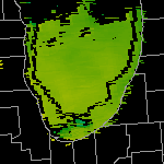
A map of the National Weather Service forecast offices participating in the MODIS in AWIPS project is available. There are currently 59 offices receiving MODIS imagery from the Cooperative Institute for Meteorological Satellite Studies (CIMSS), plus four distribution nodes.
If your office is receiving MODIS in AWIPS from CIMSS, and is not included on this list, please contact Jordan Gerth.
The following sites have planned to install MODIS imagery in AWIPS:
- None currently
Screenshots
Courtesy of Scott Bachmeier (contact)


VISITview Presentation
Courtesy of Scott Bachmeier (contact)
- VISIT Student Guide: MODIS Products in AWIPS
- Instructions for Installing the "MODIS Products in AWIPS" Session
Other Presentations and Talks
- MODIS Imagery and Products in an Operational Forecasting Environment (pdf) (ppt)
Jordan Gerth
MODIS Science Team Meeting, University of Maryland University College (Adelphi, Maryland)
November 1, 2006 (Web site)- MODIS (web, with sound; 45 minutes)
Jordan Gerth
Forecaster Introductory Review Module, National Weather Service Forecast Office at Duluth, Minnesota
August 15, 2007- MODIS Products in AWIPS: Using Research Satellites in Operations (pdf) (ppt)
Scott Bachmeier, Jordan Gerth, and Kathleen Strabala
Great Lakes Operational Meteorology Workshop, University of Wisconsin—Milwaukee School of Continuing Education
September 5, 2007
Related Links