


1. Preamble [ Back To Top ]
At the Cooperative Institute for Meteorological Satellite Studies (CIMSS) and Advanced Satellite Products Team (ASPT), there are three main goals for the GOES-12 science test. First, the quality of the GOES-12 data will be investigated. This may be accomplished by comparing to other satellite measurements or by calculating the signal-to-noise ratio. The second goal will be to produce products from the GOES-12 data stream and compare to those produced from other satellites. These products may include: temperature/moisture retrievals, total precipitable water, lifted index, cloud-top pressure, and sea surface temperatures. The third goal is to investigate the impact of the loss of the 12 µm Imager band 5 (and the addition of the 13.3 µm band 6) on both current and new Imager products.
The Science Test is scheduled to begin on September 23, 2001 and be completed on October 27, 2001.
2. Executive Summary [ Back To Top ]
New features of GOES-12's imager:
- Loss of the 12µm band (channel 5 on previous imagers)
- Addition of the 13.3µm band (channel 6)
- Broadening of the water vapor band (6.5µm)
How does the imager's new band 6 (13.3µm) band compare to the sounder's band 5 (13.3µm)? This spectral response function plot shows the difference in the spectral response functions. The imager's spectral response function is much broader than the sounder's. This weighting function plot shows the contribution weighting functions for the two bands for the standard atmosphere. The imager should measure warmer brightness temperatures in this band.
How does the imager's band 3 (6.5µm) water vapor band compare to the past imager's band 3 (6.7µm)? The new water vapor band is much broader spectrally than the old one. This bandwidth plot shows the difference between the bandwidths on GOES-8 and GOES-12. Bandwidths on GOES-9, -10, and -11 do not vary much from GOES-8. This weighting function plot shows the difference in contribution weighting functions between GOES-8 and GOES-12 for the standard atmosphere. Based on this, brightness temperatures measured with GOES-12 should be on the order of 2°K higher than GOES-8.
The difference between old and new may best be seen in this comparison of GOES-12 and GOES-8 water vapor channels. Water vapor boundaries appear smoother on GOES-12 and small scale features, such as mountain waves, are better resolved. This case study from 19-21 November 2001 further illustrates the difference between GOES-12 and GOES-8/-10.
3. First Images [ Back To Top ]
The first visible full disk image for the Imager occurred on 17 August 2001 at 18:00 UTC. This image was captured at SSEC and can be seen at the SSEC GOES-12 Page.
The first visible channel image for the Sounder occurred on 30 Aug 2001 at 16:31 UTC. This image was compared to a GOES-8 visible image from approximately the same time. Degradation in the GOES-8 Sounder is apparent. These images can be seen here for a comparison of the GOES-12 vs GOES-8 Sounders. (Use the back button on your browser to return to this page). Note that GOES-12 visible data is not yet normalized as GOES-8 data is, hence you may notice some striping in the GOES-12 image. Despite this, it is considerably brighter than the GOES-8 image.
4. Products [ Back To Top ]
Many of these products are being produced in real-time mode and can be seen on the GOES-12 Realtime Page (use the back button on your browser to return to this page). GOES-12 is not on an operational schedule, however. Therefore these products may not appear as they should at times and currently should not be used as, or considered to be, operational products.
The CIMSS Realtime GOES Page (use the back button on your browser to return to this page) contains operational satellite products for GOES-8 and GOES-10. When GOES-12 becomes operational it will be used to create these products as well.
The addition of the 13µm channel on the GOES-12 Imager makes full disk cloud products possible:

A preliminary comparison of GOES-12 (Imager and Sounder) and GOES-8 (Sounder) cloud top pressure derived product images from September 25, 2001 at 14:46 UTC shows good agreement between GOES-12 and GOES-8. GOES-12 radiances are not as noisy as GOES-8 radiances. Preliminary comparison of GOES-12 Imager to GOES-12 Sounder shows generally good correlation between the imager-based product and that produced from the full complement of GOES Sounder bands.
For a java loop showing the data for September 25, 2001 14:45 UTC click here. The 6 image loop contains a GOES-12 full disk visible image, GOES-12 full disk Imager 11µm image, GOES-12 full disk Imager 13.3µm image, GOES-12 full disk Cloud Top Pressure Imager-based product, GOES-12 Sounder Cloud Top Pressure product, and GOES-8 Sounder Cloud Top Pressure product.
4.2 - Total Precipitable Water
A preliminary real-time product (precipitable water DPI).
This display of the total precipitable water vapor (PW) as
derived from the GOES-12 Sounder is provided each hour, matching the similar
display from the "operational" GOES-8 and GOES-10 Sounders. For more
description of the GOES Sounder PW DPI as well as longer animations from
GOES-8 and GOES-10, see the
PW section
of the CIMSS Realtime GOES Page (use the back button on your browser to return).
Shorter 4-hour animation
Comparison of GOES-12 PW DPI with GOES-8 for last hour
A preliminary real-time product (lifted index). This display of the lifted index (LI) stability as derived from the GOES-12 Sounder is provided each hour, matching the similar display from the "operational" GOES-8 and GOES-10 Sounders. For more description of the GOES Sounder LI DPI as well as longer animations from GOES-8 and GOES-10, see the LI section of the CIMSS Realtime GOES Page.
Shorter 4-hour animation
Comparison of GOES-12 LI DPI with GOES-8 for last hour
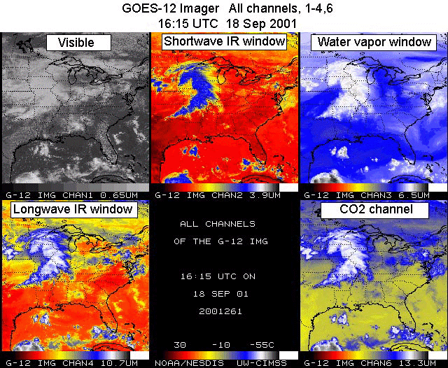
4.4 - Multi-Panel Display Of All 19 Channels From The GOES-11 Sounder
A preliminary real-time product (Sounder Radiances). Each of the 19 different spectral channels from the GOES-12 Sounder is presented in a multi-panel format. Channel 1 is shown in panel 1, starting in the upper left, with subsequently numbered channels following across rows and then down columns. The domain covers only the central and eastern US as seen from GOES-12 (a map has been added to panel 1). A single color enhancement is applied to all the 18 infrared channels, while the visible (channel 19) is shown in shades of gray. Diurnal (24 hour) animation loops further provide the viewer with the temporal nature of the everchanging atmosphere, enhancing the spatial and spectral characteristics presented in the imagery from any individual time period.
Note that the imagery has been re-mapped to a Mercator projection which permits the exact comparison with a similarly re-mapped set of all channels from the GOES-8 Sounder (for the last available hour). For more detailed information on the GOES Sounder spectral characteristics as well as the current displays of all channels from GOES-8, see the all Sounder bands section of the CIMSS Realtime GOES Page.
Shorter 4-hour animation
Interactive animation of all bands, toggling between GOES-12 and GOES-8
4.5 - Satellite-Detected Fires
Basic fire detection relies primarily on the 3.9µm (band 2) data from the GOES Imager. This provides the basis for locating the fire and other information aids in estimating the sub-pixel fire size and temperature. The number of fires that can be successfully detected and characterized is related to the upper limit of the observed brightness temperature in the 3.9µm band. The saturation temperature of the 3.9µm band limits the number of fires that can be detected and processed. The higher the saturation temperature, the greater the opportunity to identify and estimate sub-pixel fire size and temperature. Low saturation temperatures can result in the inability to distinguish fires from the hot background in places where the observed brightness temperature meets or exceeds the saturation temperature.
GOES-12 has a similar saturation temperature (approximately 336 K) to both GOES-8 and GOES-11. The sub-satellite point of GOES-8 is at the equator and 75 degrees West while for GOES-12 it is at the equator and 90 degrees West. Therefore, fire pixels observed by both instruments in the Mato Grosso region of Brazil (approximately 12 degrees South and 55 degrees West) show some variation in brightness temperature with GOES-8 tending to saturate more often than GOES-12 in South America as demonstrated in these comparisons. Three locations of active fires were selected for comparison at 1745 UTC on 2 October 2001. Even with satellite view angle differencees of 15 degrees, the comparisons shown here display relatively good agreement in the location and number of fire pixels. In all three examples, differences in clear-sky non-fire pixels are typically less than 2 degrees. In the first example the fire intensity was so great, that it more than saturated both GOES-8 and GOES-12. The GOES-8 observations of the fire activity in the first example show the fire's impact on more scan lines, which is most likely due to respective viewing geometry. The other two examples also show the impact of the satellite view angle. In example 2, the fire was just hot enough to saturate the GOES-8 4 micron band, but not hot enough to saturate GOES-12. In the third example, both instruments saturated, but there are large differences in several of the pixels, which is probably due to view angle differences and fire intensity.
A comparison of the GOES-10 to GOES-12 3.9 micron brightness temperatures was
performed for a hot spot in the 12-May-2008
Preliminary indications are that GOES-12 will perform comparably to
GOES-8 and much better than GOES-10 insofar as fire detection is
concerned.
The Biomass Burning team at CIMSS currently produces fire products
for GOES-8/10 covering North and South America. This data can be
viewed at the
Wildfire Automated Biomass Burning Algorithm page.
This link will take you to the CIMSS GOES Gallery; use the back button on your browser to return to this page.
5. Case Studies [ Back To Top ]
A comparison of the water vapor channel data shows an example where a subtle mountain wave signature is detected by
the new 6.5µm infrared channel on GOES-12's Imager.
5.2 - 09 October 2001 | Convection over Nebraska and Kansas.
-
GOES-12 Imager visible data are used to show an outbreak of severe convection across Nebraska and Kansas on 09 October.
This link will take you to a java animation on the CIMSS GOES Gallery; use the back button on your browser to return to this page.
5.3 - 19-21 November 2001 | GOES-12/GOES-10/GOES-08 water vapor comparisons.
-
An upper-tropospheric jet streak moving northeastward across Illinois, Indiana, and Michigan on 19 November 2001
illustrates how water vapor boundaries appear smoother in GOES-12 Imager water vapor channel imagery because of the
improved spatial resolution of the GOES-12 water vapor data compared to previous GOES imagers.
5.4 - 26 November 2001 | GOES-12/GOES-08 water vapor comparison
-
A deep cyclone intensifying over Nebraska on 26 November 2001, producing a mixture of winter precipitation across parts of the northern plains states. Features are more clearly depcited on the GOES-12 Imager water vapor channel imagery.
Use the back button on your browser to return to this page.
6. Calibration [ Back To Top ]
6.1 - Scan Mirror Emissivity Coefficients
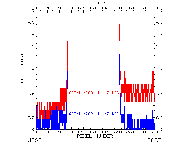
On October 11, 2001 SOCC installed a new set of scan-mirror emissivity coefficients in the GOES-12 calibration for both the Imager and the Sounder. These coefficients are used in the algorithm that corrects for the east-west scan-angle dependence of the emissivity (and reflectance) of the Imager's and Sounder's scan mirrors. Earlier, the GOES-12 calibration had used emissivity coefficients calculated from another GOES. The new coefficients were specific to GOES-12, as they were derived from on-orbit GOES-12 data.
The change is most evident in imager band 6. A before and after plot shows how the change was verified by comparing space-looks on the west and east side of two images. The "before" image is from October 11, 2001 at 14:15 UTC. The "after" image is from October 11, 2001 at 14:45 UTC. Note that the y-axis (radiance) of the plot has been limited to show the space-view. In the middle of the x-axis the earth-view pixels are scaled off the y-axis of the plot. There is definite improvement seen in the after image.
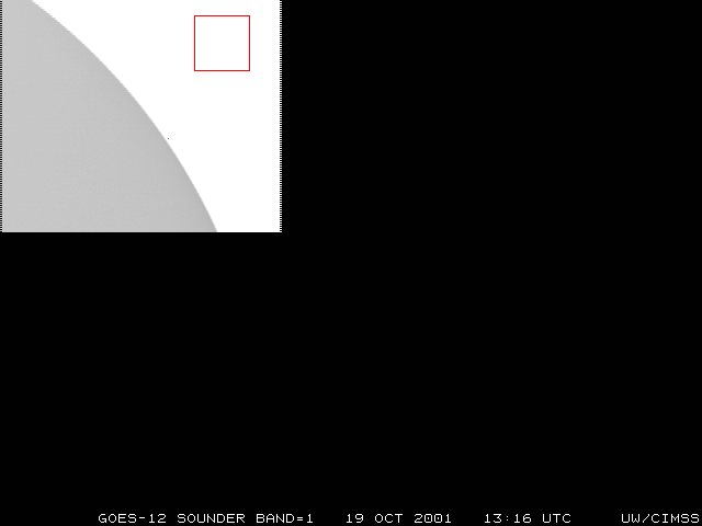
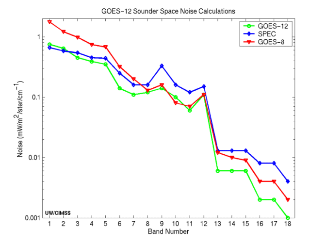
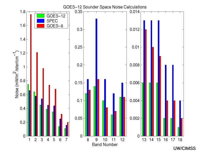
Special GOES-12 Sounder sectors which include space views allow noise values to be determined by the scatter of radiance values looking at uniform space. Preliminary indications from October 19 at 13:16 UTC show that GOES-12 appears to be within specification for most bands. This line plot or bar plot comparing GOES-8 & GOES-12 to specs illustrates the improvement over GOES-8 noise values in the shortwave and longwave infrared. The GOES-12 signal to noise values (mW/m2/ster/cm-1) compared well to those from other satellites:
Wavelength  Channel  GOES-8   GOES-9   GOES-10   GOES-11   GOES-12	SPEC
  14.70        1       1.76    1.16      0.71      0.67    0.75		0.66
  14.40	       2       1.21    0.80      0.51      0.51    0.64		0.58
  14.10	       3       0.98    0.56      0.41      0.37    0.45		0.54
  13.90	       4       0.74    0.46      0.41      0.36    0.39		0.45
  13.40	       5       0.68    0.45      0.36      0.34    0.35		0.44
  12.70	       6       0.32    0.19      0.16      0.17    0.14		0.25
  12.00	       7       0.20    0.13      0.09      0.11    0.11		0.16
  11.00	       8       0.13    0.09      0.12      0.14    0.12		0.16
   9.70	       9       0.16    0.11      0.10      0.13    0.14		0.33
   7.40	      10       0.08    0.08      0.07      0.09    0.10		0.16
   7.00	      11       0.07    0.05      0.04      0.06    0.06		0.12
   6.50	      12       0.11    0.09      0.07      0.11    0.11		0.15
   4.57	      13       0.012   0.008     0.007     0.006   0.006	0.013
   4.52	      14       0.010   0.007     0.005     0.007   0.006	0.013
   4.45	      15       0.009   0.006     0.005     0.006   0.006	0.013
   4.13	      16       0.004   0.003     0.003     0.003   0.002	0.008
   3.98	      17       0.004   0.003     0.002     0.003   0.002	0.008
   3.70	      18       0.002   0.001     0.001     0.001   0.001	0.004
A detailed table of the GOES-12 Sounder noise calculations shows the program output.
Full disk images of the Imager also provide space views and allow noise values to be determined using the same methodology described for the sounder above. Preliminary noise values (mW/m2/ster/cm-1) for the GOES-12 imager from November 05, 2001 at 21:00Z (alongside GOES-11's preliminary noise values) are:
Wavelength  Channel  GOES-11	GOES-12
    3.9        2       0.005	  0.008
    6.8        3       0.03	  0.02
   10.7        4       0.12	  0.17
   12.0        5       0.31 	   na
   13.3        6        na	  0.32
A detailed table of the GOES-12 Imager noise calculations shows the
program output.
Noise values for all Imagers in Kelvin:
Wavelength   Channel   GOES-8  GOES-9  GOES-10  GOES-11	  GOES-12   SPEC
    3.9		2	0.16	0.08	0.11	 0.13	   0.21     1.40
    6.8		3	0.27	0.15	0.14	 0.20	   0.16     1.00
   10.7		4	0.12	0.07	0.09	 0.07	   0.10     0.35
   12.0		5	0.20	0.14	0.19	 0.18	   na       0.35
   13.3		6	na	na	na	 na	   0.18     0.35
At 18:05 UTC November 05, 2001 (2001309) GOES-12 was switched to match the schedule of GOES-10. A comparison between GOES-10 and GOES-12 Imagers revealed good agreement in Brightness Temperatures at the mid-point between the two satellites (0 North, 112.5 West).
| Satellite | Band | Rad | Temp |
| (Imager) | # | mW/m2/cm-1/ster | K |
| GOES-10 | 2 (3.9µm) | 0.628 | 289.8 |
| GOES-12 | 2 (3.9µm) | 0.598 | 289.6 |
| GOES-10 | 3 (6.7µm) | 9.061 | 255.2 |
| GOES-12 | 3 (6.5µm) | 8.486 | 257.5 |
| GOES-10 | 4 (10.7µm) | 92.556 | 288.5 |
| GOES-12 | 4 (10.7µm) | 92.917 | 288.4 |
A bar chart illustrates the brightness temperature differences between GOES-12 and GOES-10 for this case. For the program input and output, see this text file.
~ Under Construction ~
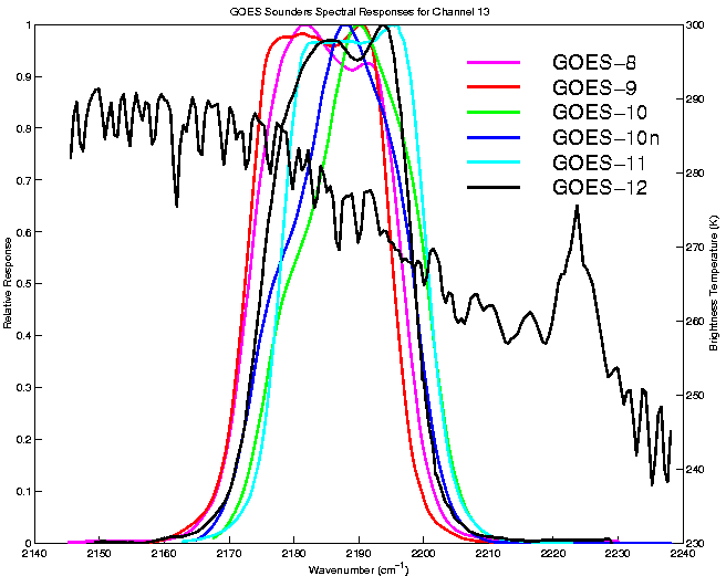
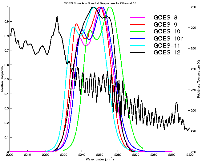
A preliminary comparison is available in an animated format, showing all 19 bands from both the GOES-12 and GOES-8 Sounders at 20:46 UTC on 20 Sep 2001. (Other later time periods are also available and may be examined with use of the toggling option in the animation tool.) Favorable overlap in coverage between the satellites is considerable. Although patterns and overall ranges match reasonably well, some differences are obvious. GOES-12 Sounder data appear markedly less noisy (than GOES-8 data). GOES-12 Sounder visible data appear brighter. Although fine tuning of calibration may continue through the check out and test period, some initial differences between the observed radiances from the two satellites result from known differences in the respective spectral response functions (see examples below, as for bands 13 or 15).
6.6 - Spectral Response Functions
The normalized Spectral Responses give indications of the expected radiance differences between sensors or instruments.
Imager:
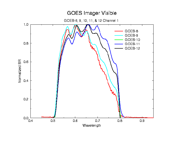
- Imager Visible Spectral Responses for GOES-8, 9, 10, 11 and 12
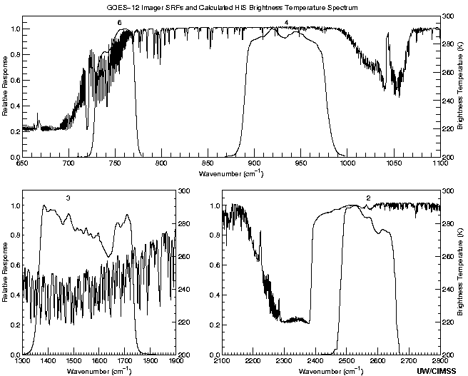
- Imager Spectral Responses for GOES-12 compared to Calculated HIS Spectrum
Sounder:
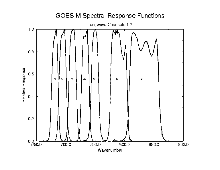
- Sounder Spectral Responses for GOES-12 (Longwave Bands 1-7)
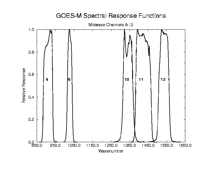
- Sounder Spectral Responses for GOES-12 (Midwave Bands 8-12)
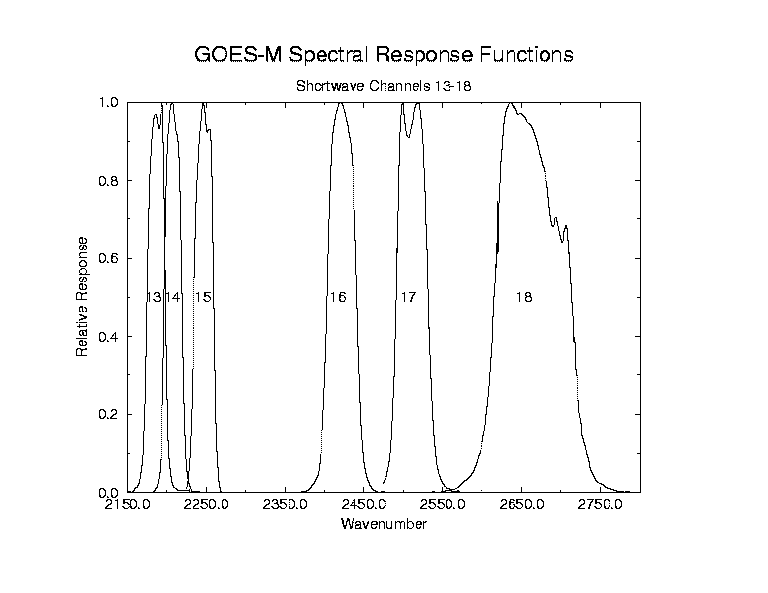
- Sounder Spectral Responses for GOES-12 (Shortwave Bands 13-18)
- Sounder Spectral Responses for GOES-12 compared to Calculated HIS Spectrum
- Sounder Spectral Responses for GOES-8, 9, 10 and 12 (Band 13)
- Sounder Spectral Responses for GOES-8, 9, 10 and 12 (Band 15)
6.7 - Sounder Calibration Mode
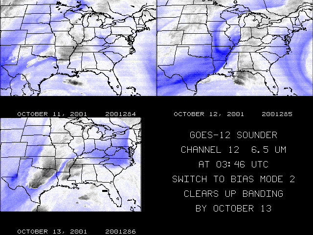
There was a change to the GOES-12 Sounder calibration mode (from Mode 1 to Mode 2) on 10/11/2001. Prior to the change there was banding evident in bands 12 and 15. The banding was most evident at approximately 4:00 UTC. Infrared calibration bias factors may vary as the temperature of instrument optical components vary; between space looks, this variation may appear as banding in the imagery. Switching to Mode 2 appears to have reduced banding in band 12 and band 15. A comparison for channel 12 at 3:46 UTC on October 11, 12, and 13 reveals reduced striping after switching to Mode 2.
The effect on all channels can be seen in this java animation which shows all 18 bands of the GOES-12 Sounder for 3:46 UTC on October 10 (Mode 1) through October 15 (Mode 2). Notice the change in bands 12 and 15 evident on October 13.
The switch to bias mode 2 occurred on October 11 but the elimination of banding did not take place until October 13. This is due to the fact that the optics temperature used for regression in sounder calibration was not updated until October 12. Bias mode 2 is only effective when the correct regression is used.
~ Under Construction ~
7. Documents [ Back To Top ]
8. Calendar of Scheduled Events [ Back To Top ]
July 2001 August 2001 September 2001 October 2001 November 2001 December 2001
9. Schedules [ Back To Top ]
GOES-12 SCIENCE TEST SCHEDULES
C1RAP_XXX(Central Rapid_XXX=J-day) - Continuous imager conus scan operations. An imager conus scan occurs every 5 minutes and 26 minute east conus soundings occur every half hour. A two hour prior notification is needed for switching the imager conus area of coverage to the Atlantic or Pacific Hurricane conus or the Central/S.America imager scan. A two hour prior notification is needed for switching sounder scan sectors. Available sounder sectors are West Conus, Gulf of Mexico, Tropical Pacific, Caribbean, Volcano sector, Central/S.America and the East or West Limb scan sectors.
C2SRSO_XXX(Central Super Rapid Scan Operations_XXX=J-day) - Continuous 1 minute imager scan operations. A two hour prior notification with a latitude and longitude center point is required to select the 1 minute scan area of continuous coverage. An imager conus 5 minute scan occurs every hour and 26 minute east conus soundings occur every half hour. A two hour prior notification is needed for switching sounder scan sectors. Available sounder sectors are West Conus, Gulf of Mexico, Tropical Pacific, Caribbean, Central/S.America, Volcano sector and the East or West Limb scan sectors.
C3_XXX - Continuous imager conus 5 minute scan operations with continuous 9 minute soundings of Colorado. A two hour prior notification is needed to switch the sounding scan sectors. Available sounder sectors are Oklahoma and Hurricane soundings 10,11 or 12.
C4_XXX - Continuous 8 minute S.America imager scans with hourly soundings of S.America.
C5_XXX - Continuous imager and sounder scan operations that closely emulate the GOES-East scan operations.
C6_XXX - Continuous 2 minute imager scan operations over the Gulf of Mexico. An imager conus 5 minute scan occurs every hour and 26 minute east conus soundings occur every half hour. A two hour prior notification is needed for switching sounder scan sectors. Available sounder sectors are West Conus, Gulf of Mexico, Tropical Pacific, Caribbean, Volcano sector, Central/S.America and the East or West Limb scan sectors.
Click here for a table version of the science test schedule.
10. Links [ Back To Top ]
Use your browser's "back" button to return to this page:
- NOAA GOES Calibration Page
- CIMSS GOES-12 Blog
- CIRA RAMSDIS Online
- CIMSS GOES-11 Science Report
- Back to the CIMSS Home Page
Unless otherwise noted, all satellite data are provided by the Data Center at the Space Science and Engineering Center (SSEC) of the University of Wisconsin - Madison and are displayed using McIDAS, the Man computer Interactive Data Access System.
Last Updated: 05 November 2001 Disclaimer.
URL: http://cimss.ssec.wisc.edu/goes/g12_report