GOES water vapor comparison - 17:32 UTC (re-mapped to Lambert conformal projection) |
|
|
GOES water vapor comparison - 17:32 UTC (re-mapped to Lambert conformal projection) |
|
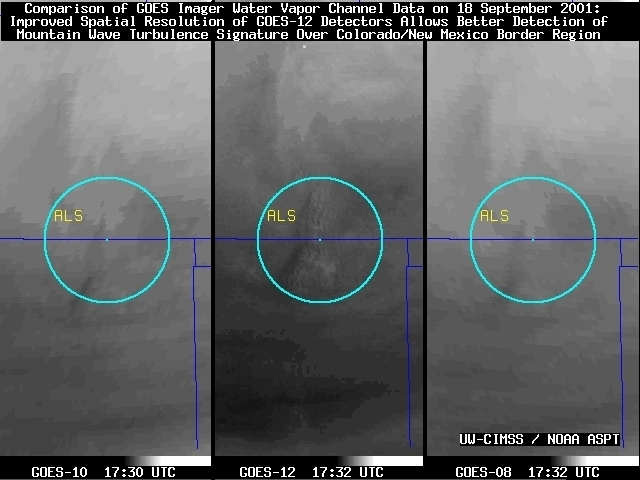
A comparison of the "water vapor" channel data from the NOAA GOES-12, GOES-10, and GOES-08 (above, left) shows an example where a subtle mountain wave signature is detected by the new 6.5 micrometer InfraRed (IR) channel on GOES-12 (Animation), which is not as obvious on either the GOES-10 (Animation) or the GOES-08 (Animation) 6.7 micrometer IR channel. This mountain wave signature on the water vapor channel is often an indicator of potential clear air turbulence. There were a few pilot reports of light-to-moderate or moderate turbulence aloft over this region (above, right), including a report at 33,000 feet over Alamosa CO at 16:56 UTC (located at ALS on the water vapor images above), and also at 10,500 feet over Albuquerque NM at 19:41 UTC on 18 September 2001. This mountain wave turbulence was a result of strong westerly winds associated with an upper-level jet streak moving across the southern Rocky Mountains that day.
The new GOES-12 water vapor channel has an improved spatial resolution (4 km in both the N-S and W-E directions) and is spectrally wider compared to the water vapor channel on GOES-10 and GOES-08. Both of these factors make a contribution to the better detection of the mountain wave signature over the Colorado/New Mexico border region.
On the 3-panel water vapor channel comparison above, the same enhancement is applied to all 3 images -- note that the GOES-12 image appears somewhat warmer (darker enhancement) than either GOES-10 or GOES-08 over much of the region. Average satellite brightness temperatures measured over the mountain wave signature region (within the cyan circles) were about 3 degrees K warmer on GOES-12 than on GOES-10 or GOES-08. Similarly, using the GOES-12, GOES-10 and GOES-08 weighting functions calculated from the 19 September 00:00 UTC Albuquerque NM rawinsonde profile, the theoretical water vapor channel brightness temperatures at that point should have been about 3.5 degrees warmer on GOES-12 (244.7 K / -28.45 C) than on GOES-10 or GOES-08 (241.2 K / -31.95 C). Water vapor weighting functions calculated for a U.S. Standard Atmosphere suggest that GOES-12 brightness temperatures should normally be about 2 K warmer than GOES-08, since the GOES-12 channel senses radiation from a layer somewhat lower in the troposphere.
