GOES-12 Sounder Calibration Mode ChangeAt the request of several users, OSO/SOCC will change the MSPS Calibration Mode for GOES-12 Sounder to Cal Mode 3. This Cal Mode does long-term averaging of the Sounder IR calibrations to smooth out the cals and reduce the striping seen in some images. This change was made on Monday, December 6, at the Housekeeping period around 1830Z. This will not cause any loss of data or period of bad data, just a reduction of striping. For the GOES-12 sounder, SOCC will change the operational processing to utilize sounder gain mode 3 (to average slopes over a two-hour period with data from today and the three previous days) on Dec. 6. Based on NOAA/NESDIS Scientist Dejiang Han's recent off-line studies, that will remove the striping that seems to accompany the current operational use of bias mode 2. Gain mode 3 can only be used when the patch temperature is controlled, so it may need to be turned off when the patch temperature floats above 94K, i.e., between mid-April and the end of August. You can view a short animated loop of extremely enhanced GOES-12 CONUS band 12 images which show a "before" and "after" view of the implementation. There was still striping evident between about 3:46 and 7:46 the following day, but after several days there is very little striping evident. This can be seen in this 96 image CONUS band 12 animation (WARNING! 96 images may take a long time to load on slower connections!)
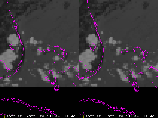
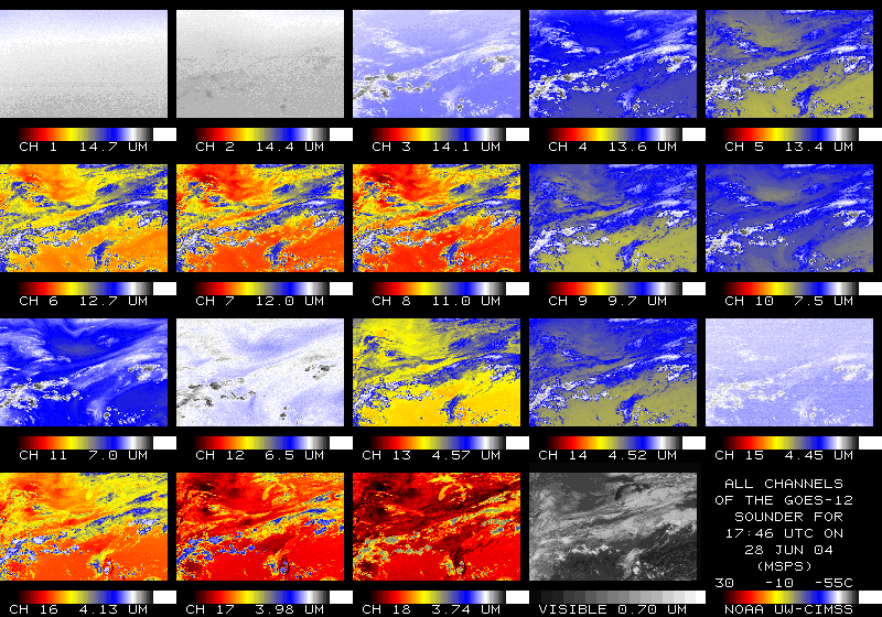
GOES-12 MSPS (SPS-9) Testing at SSEC/CIMSSFor about 48 hours on 28 and 29 June, 2004 GOES-11 was used to broadcast a parallel stream of GOES-12 data. This parallel data differed from the operational GOES-12 data stream only in that it was processed using a different SPS (Sensor Processing System), dubbed MSPS (Modern SPS). In the GVAR data stream the MSPS is flagged as SPS-9 and the operational stream is SPS-1. MSPS is actually SPS version 6.1.3 and the currently operational (for GOES-10 and -12) SPS is version 5.1.2. There are issues unique to local ingestion of GOES-12 MSPS data via GOES-11 at SSEC. The SSEC Data Center has ingested and archived this data but has to do so on a slightly less reliable antenna. This antenna can create more noise in the imagery. ImagerFor the Imager, there appears to be very little difference between SPS and MSPS. There are very small differences that amount to a difference of 1 GVAR count which is considered insignificant and not unexpected. There are also differences seen between the two which may actually be noise or some other artifact that is not necessarily due to the new SPS.Since most of the differences are small, the images look identical to the human eye. A comparison of all Imager bands on 29 June 2004 at 11:45 UTC reveals that there is no easily recognizable difference between the MSPS and SPS data. See them animated here in a Java loop. For one full disk image time period on 29 June 2004 at 14:45UTC a somewhat more indepth look was taken at a comparison between SPS and MSPS. Imager band 4 (11µm) SPS data from SSEC was compared to MSPS data ingested in DC (not noise free, but less noisy than the SSEC MSPS ingestion). A full disk image contains 2705x5212, or a total of 14,098,460 fields of view (FOV). For this case, 36,366 FOVs were different. Of the 36,366 FOVs that were different, 36,197 of them were off by just one count (MSPS one GVAR count higher than SPS). So 99.54% of the difference between MSPS and SPS was 1 GVAR count (MSPS higher than SPS). In addition there were 17 pixels off by 1 GVAR count in the other direction (SPS 1 GVAR count higher than MSPS). After that there are just 152 pixels in the entire image that are different beyond one count in either direction. A histogram showing the number of different pixels for each possible GVAR count difference (count runs from 0 to 1023 so possible differences are from -1023 to +1023) with a truncated y-axis has been created. The y-axis is truncated because we know that there were 14,062,094 instances of zero difference, 36,197 instances of -1 difference and 17 instances of +1 difference. No other difference value had more than 9 occurences. It also would appear that the fields of view with differences between SPS and MSPS are scattered around the earth with no apparent pattern, as can be seen in this diagram on a latitude/longitude grid displaying a dot at the location of every different FOV. SounderFor the Sounder, the biggest issue we've seen is that it appears the navigation via the MSPS is off by perhaps 20km, or about 2 FOVs. Perhaps related to that, the MSPS and SPS seem to report slightly different spatial resolutions for the sounder data. The MSPS reports Sounder resolution as 13.98x10.74 km versus 14.00x10.75 km for the operational SPS. This side by side comparison of Sounder data from 28 June 2004 17:46 UTC shows how the MSPS data navigation appears to be off.
We did not notice any worrisome differences in the radiance data. Reported SPS times are slightly different (on the order
of milliseconds). A comparison of all Sounder bands
on 28 June 2004 at 17:46 UTC reveals that there is no easily recognizable difference between the
MSPS and
SPS data. See them
animated here in a Java loop. For more information you can view this McIDAS
text output with some comparison statistics.
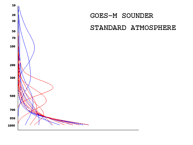
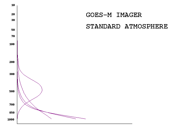
Here are the GOES-12 sounder and
imager weighting functions.
Here is the output from the weighting function program:
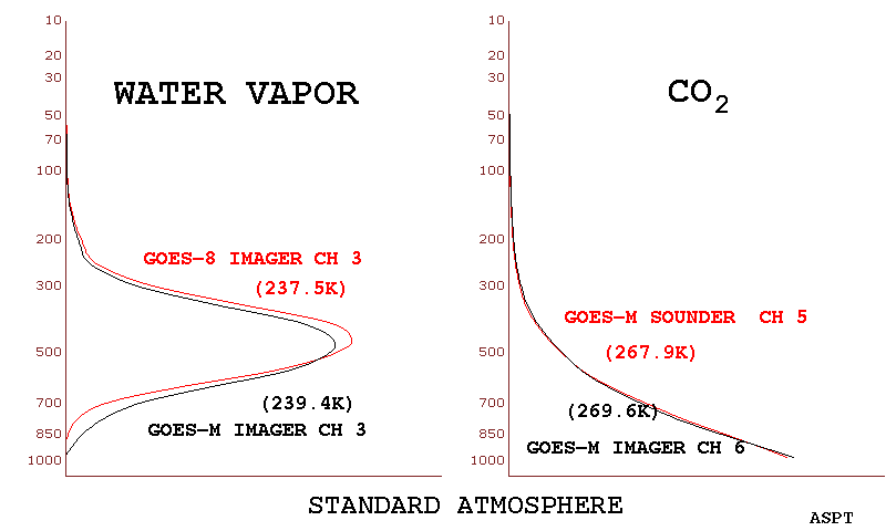
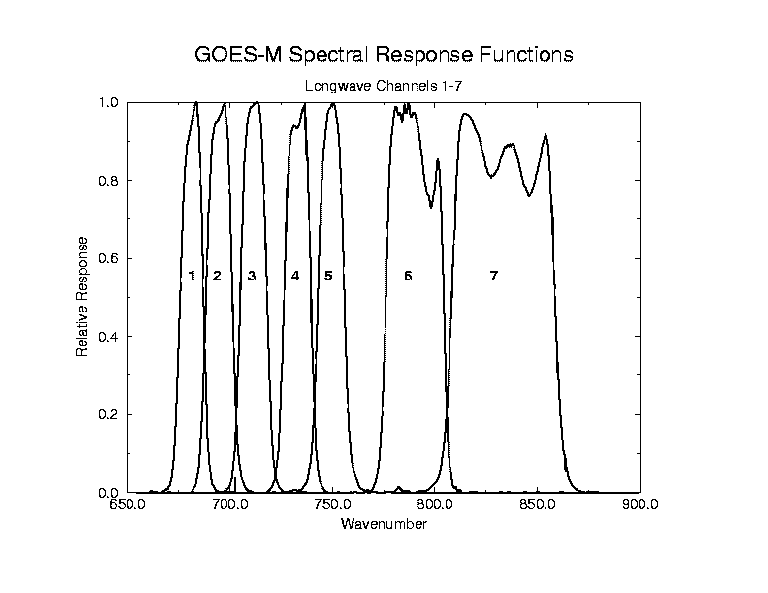
The GOES-M imager will be the first in its series with a 13.3 micron
channel (although it will not carry the 12 micron channel) and a
spectrally
wider water vapor channel (with an increased resolution in the north-south
direction). The plot of
weighting functions shows
that for the same atmosphere, the water vapor channel on GOES-M will sense
a warmer temperature (two degrees for the standard atmosphere); the new
13.3 micron channel is similar to that of channel 5 on the current sounders
(although the new imager channel again will sense warmer, due to its
increased spectral width).
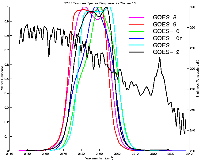
The GOES-8/9/10/10n/11/12 Channel
13 spectral response functions with
the calculated HIS brightness temperature spectrum. Note that GOES-10n represents the updated spectral
response function for GOES-10.
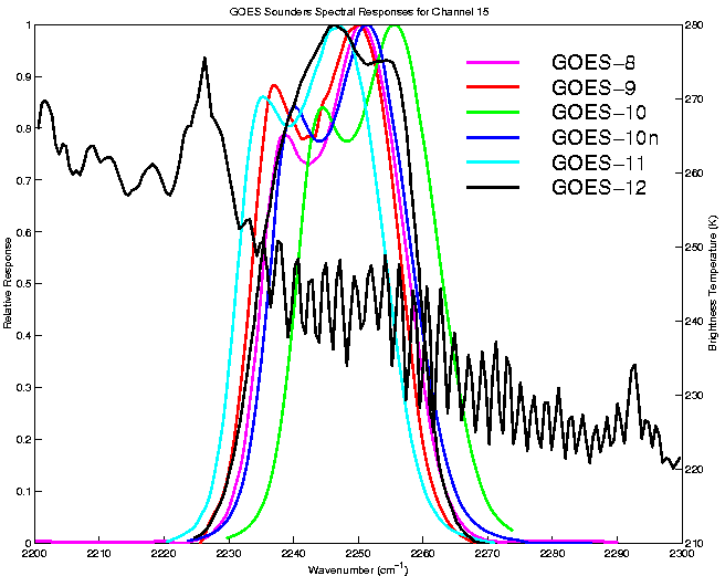
The GOES-8/9/10/10n/11/12 Channel
15 spectral response functions with
the calculated HIS brightness temperature spectrum.
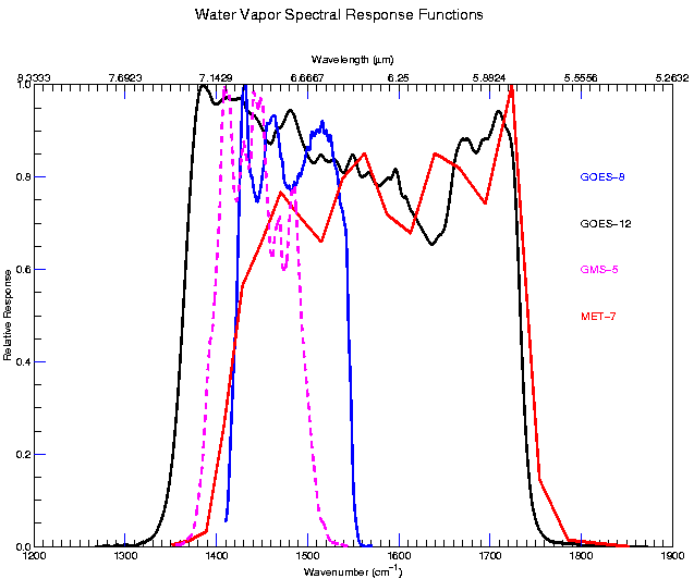
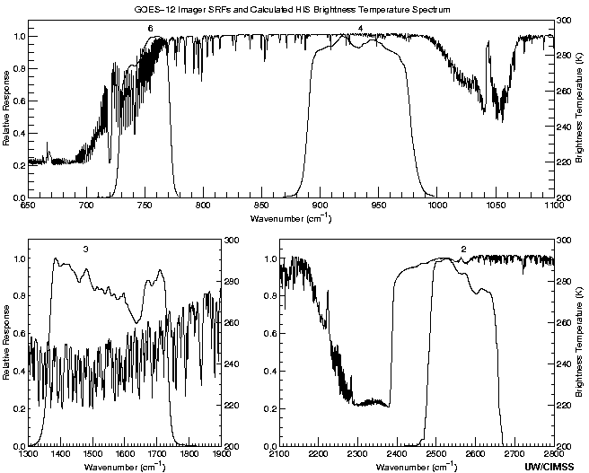
The
GOES-12 SRF for the water vapor channel (channel 3) covers a broader band than previous
GOES instruments. Note the coverage is more similar to that of the European's METEOSAT-7.
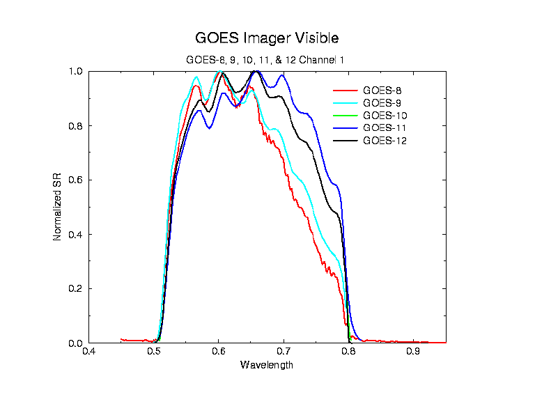
The GOES-/8/9/10/11/12
imager spectral response functions for channel 1 (visible). Note that GOES-11 continued
the trend that has the spectral response moving toward higher wavelengths; however, GOES-12 is
nearly identical to GOES-10.
Note the addition of Channel 6 - previous GOES imagers had a Channel 5, however this instrument does not.
|
The CIMSS Sounder Tutorial
Back to the CIMSS Home Page
Revised - June 18, 1999.
URL: http://cimss.ssec.wisc.edu/goes12_blog