


Contributors: Scott Bachmeier, Mathew Gunshor, Jim Nelson, Tim Schmit, Tony Schreiner, Dave Stettner, & Gary Wade.
1. Preamble [ Back To Top ]
At the Cooperative Institute for Meteorological Satellite Studies (CIMSS) and Advanced Satellite Products Team (ASPT), there were two main goals for the GOES-11 science test. First, the quality of the GOES-11 data was investigated. This was accomplished by comparing to other satellite measurements or by calculating the signal-to-noise ratio. The second goal was to produce products from the GOES-11 data stream and compare to those produced from other satellites. These products include: temperature/moisture retrievals, total precipitable water, lifted index, cloud-top pressure, sea surface temperatures, and satellite derived winds. The Science Test is scheduled to be completed on August 15, 2000.
2. Executive Summary [ Back To Top ]
The science test for GOES-11 produced several conclusions:
- Overall, the sounder satellite data from GOES-11 is slightly better than from GOES-8. GOES-11 shows both less noise and less striping.
- Retrievals of Total Precipitable Water from the GOES-11 are improved over those from GOES-8 (for co-located radiosonde observations).
- Derived Product Images of Lifted Index from the GOES-11 sounder correctly showed a large region of instability on the 24th and 25 of July where severe weather subsequently developed.
3. First Images [ Back To Top ]
The first visible channel image for the Imager occurred on 17 May 2000 at 19:00 UTC. The first visible channel image for the Sounder occurred on 22 May 2000 at 17:31 UTC. These images were compared to GOES-8 and GOES-10 visible images from approximately the same times. Degradation in the GOES-8 and GOES-10 Imagers was apparent. These images can be seen here for the Imager and Sounder. (Use the back button on your browser to return to this page).
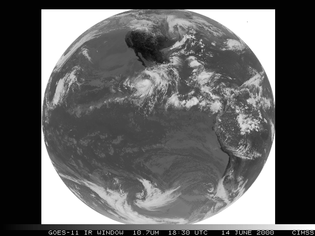
The first full disk infrared images for the Imager occurred on 14 June 2000 at 18:02 and 18:30 UTC. The most prominent meteorological phenomenon that day was Tropical Storm Bud. Full disk images for the infrared window channel (ch 4, 10.7um) and the water vapor channel (ch 3, 6.8um) are available. Additionally there are images comparing T.S. Bud in all imager infrared channels for GOES-8, GOES-10, and GOES-11. There is also a five image java loop of the full disk imager which shows all 5 bands.
4. Products [ Back To Top ]
Many of these products are being produced in real-time mode and can be seen on the GOES-11 Realtime Page. GOES-11 is not on an operational schedule, however. Therefore these products may not appear as they should at times and currently should not be used as, or considered to be, operational products.
The CIMSS Realtime GOES Page contains operational satellite products for GOES-8 and GOES-10. When GOES-11 becomes operational it will be used to create these products as well.
A preliminary comparison of GOES-11 and GOES-8 Sounder cloud top pressure derived product image from June 13, 2000 at 15:46 UTC shows good agreement. GOES-11 radiances are not as noisy as GOES-8 radiances.
A preliminary real-time product (Cloud Top Pressure). This display of the cloud top pressure (CTP) as derived from the GOES-11 Sounder is provided each hour, being similar to displays from the "operational" GOES-8 and GOES-10 Sounders. For more description of the GOES Sounder CTP DPI, see the CTP section of the CIMSS Realtime GOES Page.
Shorter 4-hour animation
Comparison of GOES-11 CTP DPI with GOES-8/10 for last hour
4.2 - Total Precipitable Water
A preliminary real-time product (precipitable water DPI).
This display of the total precipitable water vapor (PW) as
derived from the GOES-11 Sounder is provided each hour, matching the similar
display from the "operational" GOES-8 and GOES-10 Sounders. For more
description of the GOES Sounder PW DPI as well as longer animations from
GOES-8 and GOES-10, see the
PW section
of the CIMSS Realtime GOES Page (use the back button on your browser to return).
Shorter 4-hour animation
Comparison of GOES-11 PW DPI with GOES-8/10 for last hour
GOES-11 sounder moisture retrievals are better than those from GOES-8: Given the lower noise of the GOES-11 sounder radiances, the retrieval quality (compared to radiosondes) was improved over that from GOES-8. This was borne out by comparisons to co-located radiosondes (where both sounders made a retrieval). For the 50 matches, the first guess (numerical model forecast) root-mean-square error was 6.7 mm for Total Precipitable Water (TPW), while the GOES-8 retrievals were improved to 6.1 mm. Significantly, the GOES-11 retrievals improved to 5.3 mm. (View Results)
A preliminary real-time product (lifted index). This display of the lifted index (LI) stability as derived from the GOES-11 Sounder is provided each hour, matching the similar display from the "operational" GOES-8 and GOES-10 Sounders. For more description of the GOES Sounder LI DPI as well as longer animations from GOES-8 and GOES-10, see the LI section of the CIMSS Realtime GOES Page.
Shorter 4-hour animation
Comparison of GOES-11 LI DPI with GOES-8/10 for last hour
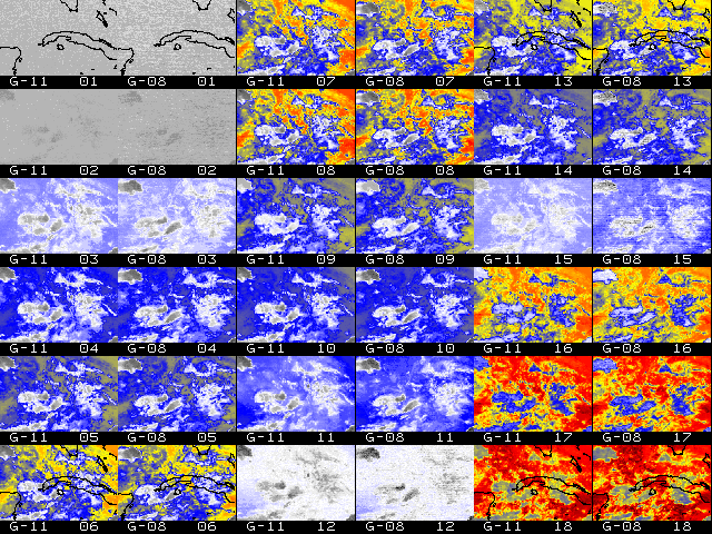
4.4 - Multi-Panel Display Of All 19 Channels From The GOES-11 Sounder
A preliminary real-time product (Sounder Radiances). Each of the 19 different spectral channels from the GOES-11 Sounder is presented in a multi-panel format. Channel 1 is shown in panel 1, starting in the upper left, with subsequently numbered channels following across rows and then down columns. The domain covers only the central and eastern US as seen from GOES-11 (a map has been added to panel 1). A single color enhancement is applied to all the 18 infrared channels, while the visible (channel 19) is shown in shades of gray. Diurnal (24 hour) animation loops further provide the viewer with the temporal nature of the everchanging atmosphere, enhancing the spatial and spectral characteristics presented in the imagery from any individual time period.
Note that the imagery has been re-mapped to a Mercator projection which permits the exact comparison with a similarly re-mapped set of all channels from the GOES-8 Sounder (for the last available hour). For more detailed information on the GOES Sounder spectral characteristics as well as the current displays of all channels from GOES-8, see the all Sounder bands section of the CIMSS Realtime GOES Page.
Shorter 4-hour animation
Interactive animation of all bands, toggling between GOES-11 and GOES-8
Winds are derived using a sequence of three images. Features targeted in the first image (cirrus cloud edges, gradients in water vapor, small cumulus clouds, etc.) are tracked within the second and third images yielding two displacement vectors. These vectors are averaged to give the final wind vector. For more information on satellite-derived winds please visit the CIMSS Tropical Cyclones Satellite-Derived Winds FAQ.
An example of GOES-11 derived winds for 19 UTC on July 31, 2000. For this example, winds were derived from a three image series of GOES-11 Imager Band 4 (11um) data. GOES-11 was in a rapid scan mode at this time and subsequently images used in this case had a five minute time interval. 31 July was chosen because of the interesting closed circulation feature centered over Lake Michigan. The distinct cloud patterns provide ample tracking targets for generating wind products. The circulation is apparent in the Band 1 (Visible) image and perhaps only slightly less so in the Band 4 (IR Window) image. Other satellite bands can be used for this same purpose, providing winds at varying heights.
The GOES-11 imager was checked for consistent image registration between bands. The process is somewhat subjective; cloud features and distinct land/water boundaries are identified and images for each band displayed at appropriate coordinates. Lake shores and rivers, and distinct cloud formations all provide sufficient detail. Movement of land features from one image to the next would indicate inconsistent image registration between bands. It was concluded that poor image registration does not appear to be a problem for GOES-11.
The Tropical Cyclones team at CIMSS currently produces Satellite-Derived Winds from GOES-8, GOES-10, METEOSAT-5, METEOSAT-7, and GMS-5 in real-time. This data can be viewed at the CIMSS Tropical Cyclones page.
4.6 - Satellite-Detected Fires
Basic fire detection relies primarily on the 3.9um (band 2) data from the GOES Imager. This provides the basis for locating the fire and other information aids in estimating the sub-pixel fire size and temperature. The number of fires that can be successfully detected and characterized is related to the calibration of the 3.9um band. The saturation temperature of the 3.9um band limits the number of fires that can be detected and processed. The higher the saturation temperature, the greater the opportunity to identify and estimate sub-pixel fire size and temperature. Low saturation temperatures can result in the inability to distinguish fires from the background in places where the observed brightness temperature meets or exceeds the saturation temperature.
A comparison of GOES-8 and GOES-11 3.9um imagery can be found here. When comparing GOES-8 and GOES-11 for fire detection it is important to note the sub-satellite points for GOES-8 (Equator, 75W) and GOES-11 (Equator, 105W). Several fires are shown within the region near the Brazil/Bolivia border on July 18, 2000 at 17:45 UTC. Fire A is saturated in both GOES-8 and GOES-11 imagery, with temperatures of 338.1K and 335.3K and satellite viewing angles of 19 deg and 49 deg, respectively. GOES-11 appears to have a comparable saturation temperature to GOES-8, and is much better suited to fire detection than GOES-10, which has a 3.9um saturation temperature of approximately 320K. Fire B is a cooler fire, reading 317.1K on GOES-8 and 308.6K on GOES-11. The difference in observed brightness temperature is due to several factors, most notably, viewing geometry. GOES-11 is viewing the fire from a more oblique angle than GOES-8 (46 deg and 17 deg, respectively) and through a different atmosphere. Furthermore, a greater number of heat signatures observed by GOES-8 in central Bolivia (location C) are due in part to closer proximity of GOES-8 to this region allowing for detection of smaller sub-pixel fires. The satellite viewing angles for GOES-8 and GOES-11 are approximately 19 deg and 49 deg, respectively.
Preliminary indications are that GOES-11 will perform comparably to GOES-8 and much better than GOES-10 insofar as fire detection is concerned.
The Biomass Burning team at CIMSS currently produces fire products for GOES-8/10 covering North and South America. This data can be viewed at the Wildfire Automated Biomass Burning Algorithm page.
5. Case Studies [ Back To Top ]
5.1 - 11 July 2000 | Severe Convection Across South Dakota
-
GOES-11 Imager and Sounder products are used to show an outbreak of severe convection across eastern South Dakota on 11 July, which produced several tornadoes, large hail (up to 4 inches in diameter), and damaging winds (60-70 mph gusts).
5.2 - 13 July 2000 | Severe Convection Across Northern Wisconsin
-
A comparison between GOES-11 and GOES-8 Sounder Lifted Index (LI). GOES-11 appears to be detecting more instability, most noticeably for this case in the vicinity of Wisconsin's Door County peninsula extending into northern Lake Michigan (note the only instance of LI requiring the red section of the color scale).
5.3 - 24-25 July 2000 | Tornado Outbreak in Nebraska
-
On July 24 GOES-11 detected high instability in Nebraska prior to a tornado outbreak.
Use the back button on your browser to return to this page.
5.4 - 31 July 2000 | Snapshot of GOES-11 Realtime Page
-
A snapshot of the GOES-11 Realtime page. There were areas of instability in the Gulf of Mexico which moved into Florida later
in the day.
Use the back button on your browser to return to this page.
6. Calibration [ Back To Top ]
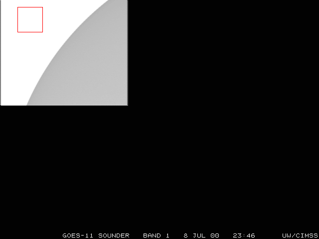
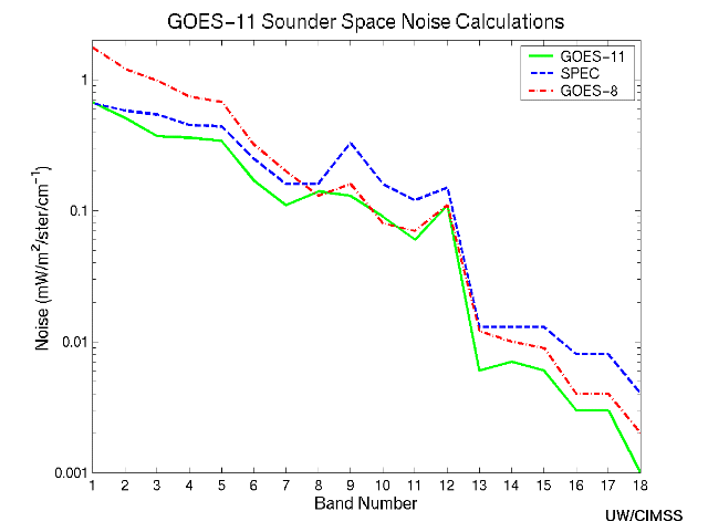
Special GOES-11 Sounder sectors which include space views allow noise values to be determined by the scatter of radiance values looking at uniform space. Preliminary indications from July 8 at 23:46 UTC show that GOES-11 appears to be within specification for most bands. This plot comparing GOES-8 & GOES-11 to specs illustrates the improvement over GOES-8 noise values in the shortwave and longwave infrared. The GOES-11 signal to noise values (mW/m2/ster/cm-1) compared well to those from other satellites:
Wavelength  Channel  GOES-8   GOES-9   GOES-10   GOES-11   SPEC
  14.70        1       1.76    1.16      0.71      0.67    0.66
  14.40	       2       1.21    0.80      0.51      0.51    0.58
  14.10	       3       0.98    0.56      0.41      0.37    0.54
  13.90	       4       0.74    0.46      0.41      0.36    0.45
  13.40	       5       0.68    0.45      0.36      0.34    0.44
  12.70	       6       0.32    0.19      0.16   05-Dec-2008.09      0.11    0.16
  11.00	       8       0.13    0.09      0.12      0.14    0.16
   9.70	       9       0.16    0.11      0.10      0.13    0.33
   7.40	      10       0.08    0.08      0.07      0.09    0.16
   7.00	      11       0.07    0.05      0.04      0.06    0.12
   6.50	      12       0.11    0.09      0.07      0.11    0.15
   4.57	      13       0.012   0.008     0.007     0.006   0.013
   4.52	      14       0.010   0.007     0.005     0.007   0.013
   4.45	      15       0.009   0.006     0.005     0.006   0.013
   4.13	      16       0.004   0.003     0.003     0.003   0.008
   3.98	      17       0.004   0.003     0.002     0.003   0.008
   3.70	      18       0.002   0.001     0.001     0.001   0.004
A detailed table of the GOES-11 Sounder noise calculations shows the program output.
Full disk images of the Imager also provide space views and allow noise values to be determined using the same methodology described for the sounder above. Preliminary noise values (mW/m2/ster/cm-1) for the imager from July 19 at 12:00Z are:
Wavelength  Channel  GOES-11
    3.9        2       0.005
    6.8        3       0.03
   10.7        4       0.12
   12.0        5       0.31
A detailed table of the GOES-11 Imager noise calculations shows the
program output.
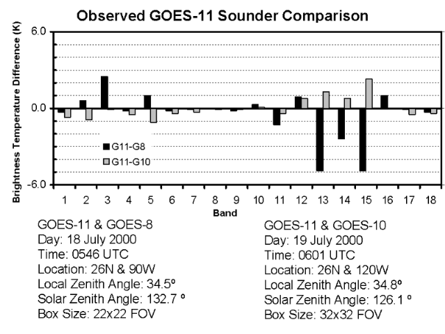
Intercomparison of the GOES Sounders: The brightness temperatures for all 18 infrared channels from the three Geostationary Operational Environmental Satellite (GOES) sounders were compared for one night-time period. Only values of similar look angles were compared. As expected, the GOES-11 sounder brightness temperatures more closely matches those from GOES-10, than the GOES-11 and GOES-8 comparisons.
A side by side preliminary comparison of sounder bands 1-18 from 13 June 2000 between GOES-8 (15:20 UTC) and GOES-11 (15:46 UTC) shows GOES-11 channels are relatively clean in this 36 panel display.
On Friday 30 June (14:42 UTC), GOES-11 sounder normalization software was installed by SOCC. As a result, less striping was evident in the sounder visible imagery (during most times of the day).
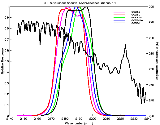
Another preliminary comparison is available in an animated format, showing all 19 bands from both the GOES-11 and GOES-8 Sounders at 2046 UTC on 14 June 2000. Favorable overlap in coverage between the satellites is considerable, following re-mapping of the imagery to a common projection (Mercator). Although patterns and overall ranges match reasonably well, some differences are obvious. As noted in the previous comparison, GOES-11 Sounder data appear markedly less noisy (than GOES-8 data). GOES-11 Sounder visible data appear brighter. And, although fine tuning of calibration may continue through the check out and test period, some initial differences between the observed radiances from the two satellites result from known differences in the respective spectral response functions (see examples below, as for bands 13 or 15). As further confirmation that the GOES-11 Sounder is performing in a stable fashion, note the consistency evident in a longer animation of GOES-11 and GOES-8 over a two day period. (Note that the java controls allow one to turn (click) off all frames but one selected pair of interest, for ease of individual comparison).
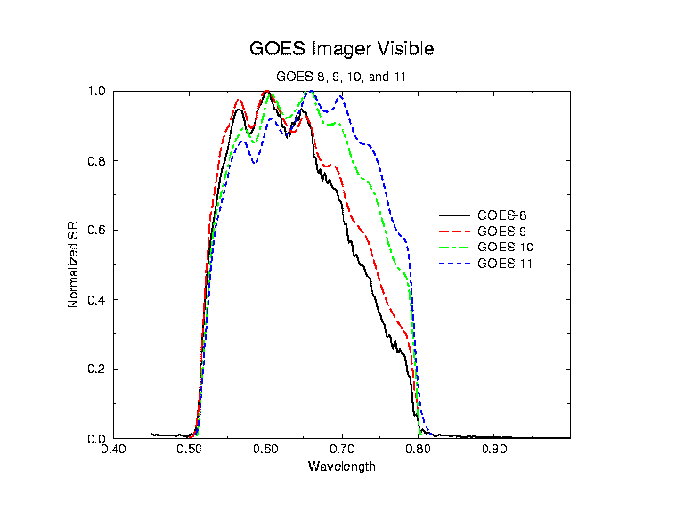
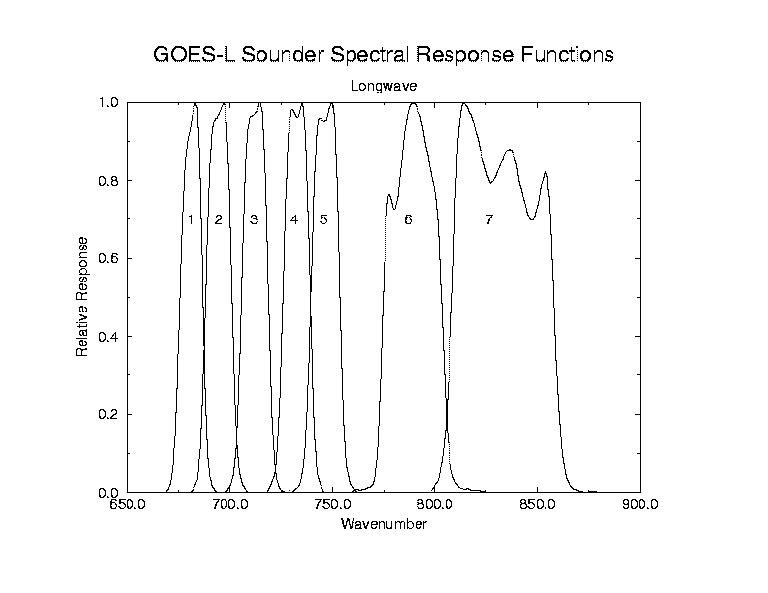
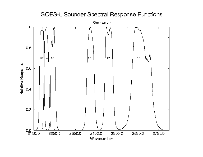
6.4 - Spectral Response Functions
The normalized Spectral Responses give indications of the expected radiance differences between sensors or instruments.
Imager:
- Imager Visible Spectral Responses for GOES-8, 9, 10, and 11
- Imager Spectral Responses for GOES-11 compared to Calculated HIS Spectrum
Sounder:
- Sounder Spectral Responses for GOES-11 (Longwave Bands 1-7)
- Sounder Spectral Responses for GOES-11 (Midwave Bands 8-12)
- Sounder Spectral Responses for GOES-11 (Shortwave Bands 13-18)
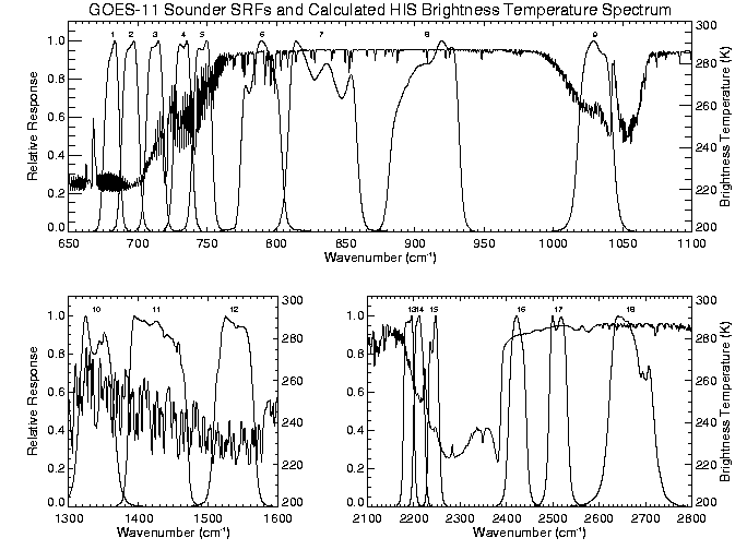
- Sounder Spectral Responses for GOES-11 compared to Calculated HIS Spectrum
- Sounder Spectral Responses for GOES-8, 9, 10 and 11 (Band 13)
- Sounder Spectral Responses for GOES-8, 9, 10 and 11 (Band 15)
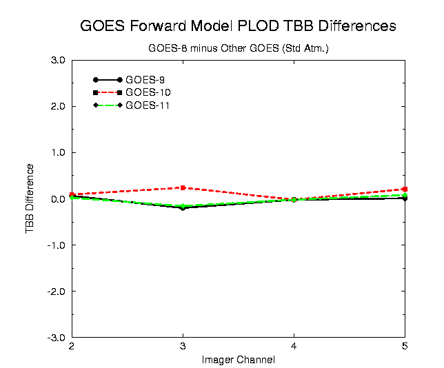
Forward Model Brightness Temperature Differences:
- Sounder Brightness Temperature Difference Plot. Note channels 13 and 15.
- Imager Brightness Temperature Difference Plot.
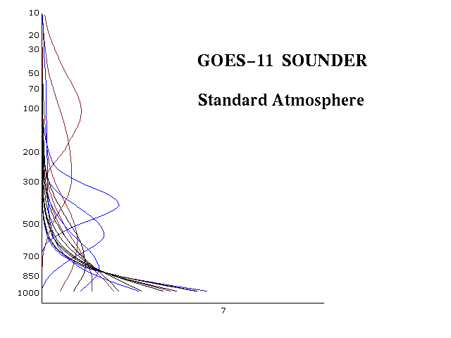
Weighting Functions:
6.5 - Sounder Calibration Mode
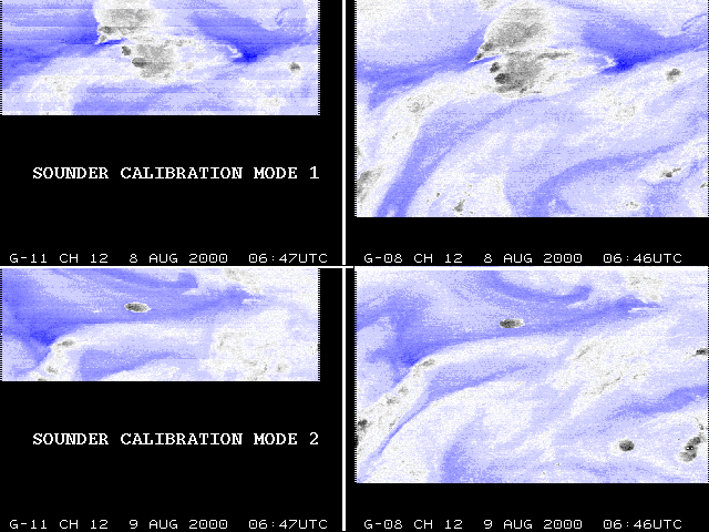
There was a change to the GOES-11 Sounder calibration mode (from Mode 1 to Mode 2) on 8/8/2000 at 13:00Z. The goal was to observe reduced striping of the observed radiances as a result of this change. Prior to the change there was striping evident in bands 12 and 15, and to a lesser extent in the shortwave bands 16-18. The striping was most evident at approximately 7:00 UTC. Switching to Mode 2 appears to have reduced striping in band 12 but not as much in band 15. The shortwave channels appeared to have reduced striping as well. A comparison for channel 12 between 7:00 UTC on August 8 and 7:00 UTC on August 9 reveals reduced striping after switching to Mode 2 (GOES-8 images are included only as a visual reference to the status of the current operational sensor).
The effect on all channels can be seen in this animation which shows all 18 bands of the GOES-11 Sounder for 7:00 UTC on August 8 (Mode 1) and 24 hours later at 7:00 UTC on August 9 (Mode 2).
GOES-11 and NOAA-14 HIRS and AVHRR Infrared Window Channels were inter-compared for two cases. The results were favorable and comparable to the results seen when comparing GOES-8 and GOES-10 to NOAA-14. The two cases were 15 July 200 at 10:45 UTC and 17 July 2000 at 10:45 UTC. For more information on intercalibration techniques, see the Intercalibration Homepage.
7. Calendar of Scheduled Events [ Back To Top ]
May 2000 June 2000 July 2000 August 2000
8. Links [ Back To Top ]
Use your browser's "back" button to return to this page:
- NOAA GOES Calibration Page
- CIMSS GOES-11 Blog (Archive)
- CIRA RAMSDIS Online with links to their GOES-11 Science Test page
- Back to the CIMSS Home Page
Unless otherwise noted, all satellite data are provided by the Data Center at the Space Science and Engineering Center (SSEC) of the University of Wisconsin - Madison and are displayed using McIDAS, the Man computer Interactive Data Access System.
Last Updated: 08 January 2001 Disclaimer.
URL: http://cimss.ssec.wisc.edu/goes/g11_report