The CIMSS Realtime GOES Page

(Animate this!)
 Processing status: 18Feb2008, 1743Z: NORMAL PRODUCTION (JPN).
Credits. Unless otherwise noted, all satellite data are provided by the
Data Center at the
Space Science and Engineering Center (SSEC) of the
University of Wisconsin - Madison and are displayed using
McIDAS, the Man computer Interactive Data Access System.
[For those using McIDAS to gain ADDE access to the satellite data used in these displays, use the "CIMSSP" server, set with: DATALOC ADD CIMSSP VERN.SSEC.WISC.EDU .]
Disclaimer. The products from GOES (Geostationary Operational Environmental Satellite) shown here are
experimental. These are generated and maintained within a research
environment (here at CIMSS (Cooperative Institute for Meteorological Satellite Studies)) and are not intended to be considered operational. Timeliness,
availability, and accuracy are sought but not guaranteed.
GOES Sounder Derived Products: Precipitable Water
| Lifted Index/CAPE | Cloud Top Pressure
| Ozone
GOES Imager Derived Products: Clear Sky Brightness Temperature
| GOES-12 Cloud Information
 Higher resolution displays of GOES Sounder DPI for the Wisconsin region
Interactive selection for time series plots of DPI values
Difference of GOES PW and other parameters from their first-guess values
Latest Derived Product GIF Images
| Derived Product GIF Archive
Individual GOES Sounder Bands:
Multi-Panel Display (East or West)
| Composites of Selected Bands
|
Toggle between Bands
List current number of GOES Sounder retrievals generated hourly
Recent Changes (31-Mar-2006)
For the latest status of the operational GOES satellites, please check the NOAA Satellite Information System web page (NOAASIS). Outages may be predictable, as scheduled during eclipse situations and for maneuvers; or, they may be impromptu, as during periods of hardware or software abnormalities. Also, please be aware that hourly GOES Sounder coverage is typically rather limited in geographical coverage (emphasizing the regional US view versus the more hemispheric view routinely made with the GOES Imager).
False color enhancement schemes for satellite derived product images have remained reasonably consistent since the mid 1980s, with modification and evolution as needed.
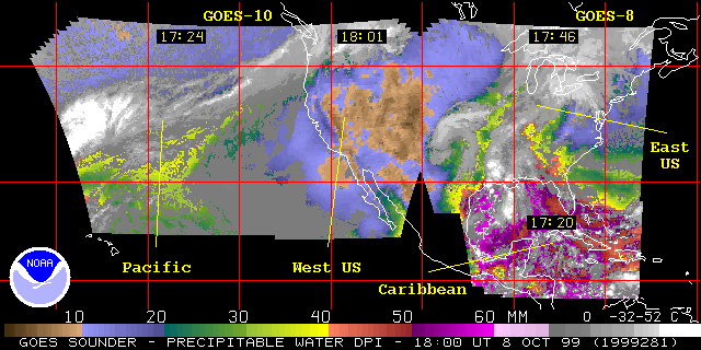
These images of derived products
have been generated from the GOES-East and GOES-West sounder
data using the physical retrieval method. The product
displayed is the total atmospheric precipitable water vapor value.
(Precipitable water is the amount of liquid water, in millimeters,
if all the atmospheric water vapor in the column is condensed.)
The value is color-coded with browns being the driest and
reds being the most moist. Clouds are represented
as a gray color (see the color bar at the bottom of the
image). A time sequence of the images is the best way to
monitor drying and moistening trends.
The images are displayed in a Mercator projection at
an effective resolution of 14 km (at the sub-satellite point,
over the equator, a field-of-view is sampled every 10 km).
The product is generated every hour.
The images are calculated using radiance measurements from
most of the longwave channels (2-8), the
water vapor channels (10-12) and most of the shortwave channels
(13-14, 16). More detailed information on the
sounder is available.
The algorithm for Derived Product Imagery (DPI) was originally developed at the CIMSS
by the NESDIS/STAR Advanced Satellite Products Branch
(ASPB), formerly
the NESDIS/ORA Systems Design and Applications Branch (SDAB).
 Combined GOES-East/West Coverage
24-hour java animation of GOES Sounder PW DPI
Shorter 4-hour animation
A closer look at the total precipitable water vapor (PW) as
derived from the GOES-East and GOES-West Sounders is provided each hour. This DPI display is
purposely shown at full resolution for viewing of smaller scale features. The nominal GOES
Sounder field-of-view (fov) is 10 km at the satellite sub-point.
The color
enhancement table uses the same color order as that used in the large scale
PW view as shown above in the GOES-East/West composites. In spring, the central US
region is frequented with return flow moisture situations; moist air
available for later convective storms over the central US often originates
from the Gulf of Mexico. During mid to late summer, moisture from the Gulf
of California region likewise is frequently available for convection over the southwestern US (the "Southwest Monsoon").
24-hour java animation of GOES Sounder SFOV PW DPI
Shorter 4-hour animation
 GIF Images for 13 Sep 2008
GIF Images for 12 Sep 2008
GIF Images for 13 Sep 2008
GIF Images for 12 Sep 2008
Three water vapor sensitive spectral bands on the Sounder (at 7.5, 7.0, and 6.5 um) provide sufficient information content to justify a display of the vertical distribution of moisture by comparing the precipitable water content within three layers of the troposphere.
These layers, for surface to 0.9 sigma ("low"), 0.9 to 0.7 sigma ("mid"), and, 0.7 to 0.3 sigma ("high"), approximately correspond to layer tops at 900 mb (1 km or 3000 ft), 700 mb (3 km or 10,000 ft), and 300 mb (9 km or 30,000 ft).
The following animation of layered PW
allows one to compare the total precipitable water with that from each of the three layers, for the last available 12 hours (with interactive selection of the layers or total).
Thus, for two separate areas with equal total precipitable water, one can determine if and how that equal total is distributed differently in the vertical for the two locations.
(The PW DPI shown are at SFOV resolution.)
The most recent 00 and 12 UTC GOES PW DPI, as described above,
are shown here with their corresponding
00
and
12
UTC radiosonde values of total precipitable water vapor (in mm) and 850 mb
wind flags. The winds have been included to provide a sense of the mean
lower level flow pattern which strongly impacts the transport of the PW.
These comparison displays are typically updated at about 05 and 17 UTC.
(Displays from previous days are also available.)
Preliminary severe weather reports over the last 24 hours (12 UTC yesterday to 12 UTC today), as available from the Storm Prediction Center , have been plotted over a representative GOES Sounder PW DPI from last evening (00 UTC).
This combination provides a simple, quick look at the level of correlation that exists between the GOES derived atmospheric moisture field and subsequent severe weather.
(Displays from previous days are also available.)
GOES Sounder precipitable water listings in text format
Simple hourly "ascii" text listings of
parameters
derived from the GOES vertical sounding profiles, including
total and layered precipitable water, are made available
on-line to be downloaded.
The files available for about the last week are labeled
by: date, time (UT), satellite (12-East, 10-West, 9-far Pacific),
and data type ("tpw") and region (a-Atlantic; c-CONUS; p-Pacific).
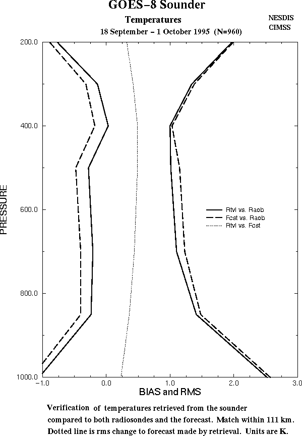
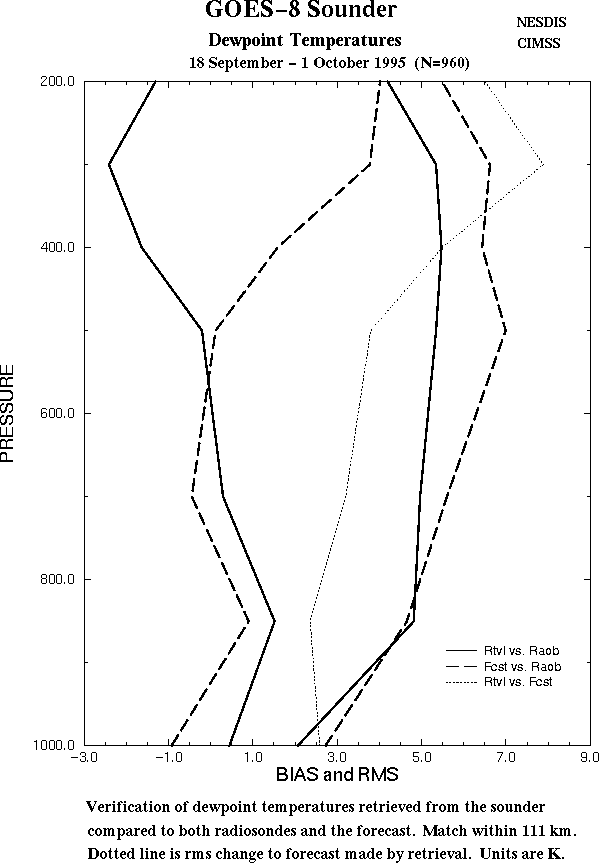
GOES Sounder verification statistics
Daily comparisons are made between the full GOES retrievals
and the radiosonde profiles of temperature and dewpoint temperatures.
These comparsions are made both at 00 and 12 UTC whenever a retrieval
is with 111 km of the radiosonde location. Similar comparisons are made between the National Environmental Prediction Center regional forecast (which serves as the first guess for the retrieval) and the radiosonde. Plots of
total precipitable water,
temperature, and
dewpoint temperature statistics are available. In general,
the GOES retrievals add information to that of the first guess
for both moisture and temperature, though more so for moisture.
A closer look at the lifted index (LI) as
derived from the GOES-East and GOES-West Sounders is provided each hour. This DPI display is
purposely shown at full resolution for viewing of smaller scale features. The nominal GOES
Sounder field-of-view (fov) is 10 km at the satellite sub-point.
This image is derived from the full physical retrieval algorithm.
The LI product displayed is an atmospheric stability
parameter which estimates the tendency of a low-level parcel of
air (lowest 100 hPa) to continue to rise if it was 'lifted'
to the middle of the atmosphere (500 hPa). The units are in degrees C.
A negative value
indicates an unstable air mass, while a positive value implies a
stable air mass.
The value is color-coded with
reds and yellows being the most unstable and blues and beiges more
stable; clouds are represented
as a gray color. (See the color bar at the bottom of the
image. The right-hand edge of each number matches the color
directly beneath it. For example, the brightest yellow
corresponds to an LI of -7C; while the brightest red, to -8C.)
A time sequence of the images is the best way to
monitor stability trends.
24-hour java animation of GOES Sounder SFOV LI DPI
Shorter 4-hour animation
GIF Images for 13 Sep 2008
GIF Images for 12 Sep 2008
The most recent 00 UT GOES LI DPI, described in the preceding text, is
shown here with corresponding
00 UTC
radiosonde values of the lifted index
stability parameter (in deg-C) and 300 mb wind flags. The winds have been
included to show the upper level flow pattern; upward vertical motions,
favorable for convective development, are often associated with the left
front and right rear quadrants of upper level jets (or wind maxima). This
comparison is typically updated around 05 UTC.
(Displays from previous days are also available.)
Preliminary severe weather reports over the last 24 hours (12 UTC yesterday to 12 UTC today), as available from the Storm Prediction Center , have been plotted over a representative GOES Sounder LI DPI from yesterday afternoon (22 UTC).
This combination provides a simple, quick look at the level of correlation that exists between the GOES derived atmospheric stability field and subsequent severe weather.
(Displays from previous days are also available.)
Combined GOES-East and GOES-West Cloud Top Pressure
Cloud top pressure (CTP) is derived from GOES-East and GOES-West Sounder
radiance information routinely at hourly intervals. Calculations,
using the CO2 Absorption Technique, are made at each field of view.
The image is then color enhanced to display 50 hPa intervals where
clouds have been identified. Due to the low-level atmospheric signal
being dominated by surface emissions, this technique is less reliable
for near surface clouds. For a more detailed explanation of this
technique, see the CIMSS GOES Automated
Service Observing System (ASOS) page.
A wider view of the CTP DPI is obtained using all available sectors observed from both the GOES-East and GOES-West Sounders.
24-hour java animation of GOES Sounder CTP DPI
Shorter 4-hour animation
GIF Images for 12 Jan 2016
GIF Images for 11 Jan 2016
23:00 UTC
, 22:00 UTC
, 21:00 UTC
, 20:00 UTC
, 19:00 UTC
, 18:00 UTC
, 17:00 UTC
, 16:00 UTC
, 15:00 UTC
, 14:00 UTC
, 13:00 UTC
, 12:00 UTC
, 11:00 UTC
, 10:00 UTC
, 9:00 UTC
, 8:00 UTC
, 7:00 UTC
, 6:00 UTC
, 5:00 UTC
, 4:00 UTC
, 3:00 UTC
, 2:00 UTC
A closer look at the CTP DPI is also provided below, with an emphasis on the 48 conterminous US states and their immediate environs.
24-hour java animation of GOES Sounder CTP DPI
Shorter 4-hour animation
GIF Images for 20 Jun 2007
15:00 UTC
, 14:00 UTC
, 13:00 UTC
, 12:00 UTC
, 10:00 UTC
, 9:00 UTC
, 8:00 UTC
, 7:00 UTC
, 6:00 UTC
, 1:00 UTC
, 0:00 UTC
GIF Images for 19 Jun 2007
A closer look is also provided for the effective cloud amount (ECA) DPI as well, again with an emphasis on the 48 conterminous US states and their immediate environs.
The ECA is a measure of the "radiative thickness" or the opacity of the cloud: an ECA of 100% allows no radiation from below to pass through, while an ECA of 10% allows considerable radiation from below to pass through the cloud, to the satellite sensor.
24-hour java animation of GOES Sounder ECA DPI
Shorter 4-hour animation
GIF Images for 20 Jun 2007
15:00 UTC
, 14:00 UTC
, 13:00 UTC
, 12:00 UTC
, 10:00 UTC
, 9:00 UTC
, 8:00 UTC
, 7:00 UTC
, 6:00 UTC
, 1:00 UTC
, 0:00 UTC
GIF Images for 19 Jun 2007
GOES Sounder cloud top pressure listings in text format
Simple hourly "ascii" text listings of cloud
parameters derived with the GOES vertical sounding data, including cloud
top pressure and temperature and effective cloud amount, are made available
on-line to be downloaded.
The files available for about the last week are labeled
by: date, time (UT), satellite (12-East, 10-West, 9-far Pacific),
and data type ("cld") and region (a-Atlantic; c-CONUS; p-Pacific).
Total column ozone is estimated every hour using GOES Sounder data. The
ozone retrieval is generated by application of a regression guess as described in Li et al. 2001. Estimates
are currently limited to cloud-free and partly cloudy regions of the GOES-8 & 10 Sounder sectors.
Each image is a "pseudo" DPI (Derived Product Image) that is generated outside of the retrieval program
by centering a colored square
(3x3 field of view box) at the estimate location. Band-8 (11.0um) is used for the image
background. Total column ozone is measured in Dobson Units (100 DU = 1 mm of
thickness at STP). Features such as upper level low pressure systems and
frontal boundaries can often be identified in the total column ozone imagery. Note to users: old
retrievals are used when the current hour's retrievals do not run. This problem will be solved shortly.
Li, J., C. C. Schmidt, J. P. Nelson, T. J. Schmit, and W. P. Menzel,
2001: Estimation of total atmospheric ozone from GOES sounder radiances
with high temporal resolution, Journal of Atmospheric and Oceanic
Technology, 18, 157-168
24-hour java animation of GOES Sounder Ozone DPI
Shorter 4-hour animation
GIF Images for 20 Oct 2010
16:00 UTC
, 15:00 UTC
, 14:00 UTC
, 13:00 UTC
, 12:00 UTC
, 11:00 UTC
, 10:00 UTC
, 9:00 UTC
, 8:00 UTC
, 4:48 UTC
, 3:84 UTC
, 3:20 UTC
, 2:56 UTC
, 1:92 UTC
, 1:28 UTC
, 0:64 UTC
, 0:00 UTC
GIF Images for 19 Oct 2010
All available sectors from the GOES-East and GOES-West Sounders are spatially combined each hour for a few select representative infrared spectral bands. The four pieces (two in the east; two in the west) typically cover the western Atlantic, eastern US, western US, and eastern Pacific; however, schedule variations do occur, as do omissions during eclipse situations. For display, these images from GOES-East and GOES-West have been re-mapped to a common projection (mercator) at an effective resolution of 14 km; the nominal resolution of a field-of-view at the sub-satellite point for a GOES Sounder is 10 km. The color scheme, from warm reds to cool blues, is maintained for each band, but the range enhanced does vary with band (to emphasize gradients in each). Note the equivalent blackbody temperature scale at the bottom of each image. The current band selection follows:
Band
Number |
Wavelength
(um) |
Principal
Gas |
Sounding
Purpose |
| 3 |
14.1 |
CO2 |
upper-level temperature |
| 5 |
13.4 |
CO2 |
lower-level temperature |
| 8 |
11.0 |
window |
surface/cloud top temperature |
| 10 |
7.5 |
H2O |
lower-level moisture |
| 11 |
7.0 |
H2O |
midlevel moisture |
| 12 |
6.5 |
H2O |
upper-level moisture |
| 15 |
4.45 |
CO2 |
upper-level temperature |
| 17 |
4.0 |
window |
surface temperature |
Note the following characteristics while comparing the different bands. Window bands 8 and 17 have the same color enhancement applied; band 17 is more transparent, but is also sensitive to reflected solar radiation (contributing energy during the daytime). Windows range widely from warm surface values to cold cloud tops. Bands 3 and 12 both sense upper portions of the troposphere; note the smaller range of temperatures. Band 3 is sensitive to the thermal energy of that region, while band 12 is sensitive to the moisture content as well. Thus, in band 3, look for the large scale thermal pattern (cool troughs and warm ridges); in band 12, look for moist ("cool") plumes and dry ("warm") slots, often clearly indicative of dynamic features ranging from jet streams to mesoscale vorticity circulations. Note that band 11 provides a look at moisture at levels lower in the atmosphere than that from band 12 (temperature values are warmer in band 11, in agreeement with the general lapse of temperature with height in the troposphere). Also notice how "clean" the radiometric signal is from band 11 (versus the noisier bands 3 or 12). Of all the water vapor channels, band 10 is influenced the most by radiation emitted from the surface. Band 15 has been included for monitoring purposes, with respect to the appropriateness of radiometric coefficients applied to the specific GOES Sounder instruments (especially historically with GOES-8); otherwise, band 15 is similar to band 3, but is within the shortwave rather than longwave CO2 absorption region.
To toggle between any pair (or more) of the images from the individual bands from the GOES Sounder at the last available hour, use the interactive "click-off/click-on" function of the following java animation applet to display only the desired bands. For example, noting that the images are loaded by increasing band number (3,5,8,10,11,12,15,17), if one wished to visually intercompare just the available water vapor bands, one would set the pattern to be: "n n n y y y n n". (Or "y n n n n y n n" for comparing the most sensitive upper level temperature and moisture bands, and so forth.)
Selectable comparison between any available GOES Sounder bands at the last hour
24-hour java animation of Band 3 from the GOES Sounder
Shorter 4-hour animation
GIF Images for 09 Jul 2008
14:00 UTC
, 13:00 UTC
, 12:00 UTC
, 11:00 UTC
, 10:00 UTC
, 9:00 UTC
, 8:00 UTC
, 7:00 UTC
, 6:00 UTC
, 5:00 UTC
, 4:00 UTC
, 3:00 UTC
, 2:00 UTC
, 1:00 UTC
, 0:00 UTC
GIF Images for 08 Jul 2008
24-hour java animation of Band 5 from the GOES Sounder
Shorter 4-hour animation
GIF Images for 09 Jul 2008
14:00 UTC
, 13:00 UTC
, 12:00 UTC
, 11:00 UTC
, 10:00 UTC
, 9:00 UTC
, 8:00 UTC
, 7:00 UTC
, 6:00 UTC
, 5:00 UTC
, 4:00 UTC
, 3:00 UTC
, 2:00 UTC
, 1:00 UTC
, 0:00 UTC
GIF Images for 08 Jul 2008
24-hour java animation of Band 8 from the GOES Sounder
Shorter 4-hour animation
GIF Images for 09 Jul 2008
14:00 UTC
, 13:00 UTC
, 12:00 UTC
, 11:00 UTC
, 10:00 UTC
, 9:00 UTC
, 8:00 UTC
, 7:00 UTC
, 6:00 UTC
, 5:00 UTC
, 4:00 UTC
, 3:00 UTC
, 2:00 UTC
, 1:00 UTC
, 0:00 UTC
GIF Images for 08 Jul 2008
24-hour java animation of Band 10 from the GOES Sounder
Shorter 4-hour animation
GIF Images for 09 Jul 2008
14:00 UTC
, 13:00 UTC
, 12:00 UTC
, 11:00 UTC
, 10:00 UTC
, 9:00 UTC
, 8:00 UTC
, 7:00 UTC
, 6:00 UTC
, 5:00 UTC
, 4:00 UTC
, 3:00 UTC
, 2:00 UTC
, 1:00 UTC
, 0:00 UTC
GIF Images for 08 Jul 2008
24-hour java animation of Band 11 from the GOES Sounder
Shorter 4-hour animation
GIF Images for 09 Jul 2008
14:00 UTC
, 13:00 UTC
, 12:00 UTC
, 11:00 UTC
, 10:00 UTC
, 9:00 UTC
, 8:00 UTC
, 7:00 UTC
, 6:00 UTC
, 5:00 UTC
, 4:00 UTC
, 3:00 UTC
, 2:00 UTC
, 1:00 UTC
, 0:00 UTC
GIF Images for 08 Jul 2008
24-hour java animation of Band 12 from the GOES Sounder
Shorter 4-hour animation
GIF Images for 09 Jul 2008
14:00 UTC
, 13:00 UTC
, 12:00 UTC
, 11:00 UTC
, 10:00 UTC
, 9:00 UTC
, 8:00 UTC
, 7:00 UTC
, 6:00 UTC
, 5:00 UTC
, 4:00 UTC
, 3:00 UTC
, 2:00 UTC
, 1:00 UTC
, 0:00 UTC
GIF Images for 08 Jul 2008
24-hour java animation of Band 15 from the GOES Sounder
Shorter 4-hour animation
GIF Images for 09 Jul 2008
14:00 UTC
, 13:00 UTC
, 12:00 UTC
, 11:00 UTC
, 10:00 UTC
, 9:00 UTC
, 8:00 UTC
, 7:00 UTC
, 6:00 UTC
, 5:00 UTC
, 4:00 UTC
, 3:00 UTC
, 2:00 UTC
, 1:00 UTC
, 0:00 UTC
GIF Images for 08 Jul 2008
24-hour java animation of Band 17 from the GOES Sounder
Shorter 4-hour animation
GIF Images for 09 Jul 2008
14:00 UTC
, 13:00 UTC
, 12:00 UTC
, 11:00 UTC
, 10:00 UTC
, 9:00 UTC
, 8:00 UTC
, 7:00 UTC
, 6:00 UTC
, 5:00 UTC
, 4:00 UTC
, 3:00 UTC
, 2:00 UTC
, 1:00 UTC
, 0:00 UTC
GIF Images for 08 Jul 2008
Since November 2001, CIMSS has been determining Clear Sky Brightness Temperature (CSBT)
information from the GOES Eastern and Western Imagers. These observed data are provided to the
National Center for Environmental Prediction (NCEP) in Washington D.C. and the
European Centre for Medium-range Weather Forecasts (ECMWF) in England for assimilation
into global weather prediction models. Processing is hourly and hemispheric with
respect to temporal and spatial coverage, respectively.
Coverage for the CSBT extends from roughly 67S to 67N and 30W to 165E. The
resolution is averaged over boxes of approximately 50 km. Each box consists of
187 (11 rows by 17 columns) fields-of-view (fovs). For a given box, a cloud
detection algorithm (Schreiner et al, 2001) is used. This clear/cloudy
determination is based on brightness temperature comparisons with neighbors
as well as surface information provided by hourly observations where available and
numerical forecasts and remotely sensed sea surface temperatures over the
oceans. For each 50 km box, the average brightness temperature for each infrared
(IR) band and the albedo for the visible band are calculated along with the
average clear and cloudy brightness temperatures. Additional parameters are the
number of clear and cloudy fovs, center latitude and longitude of the box,
central local zenith and solar zenith angles of the box, land/sea flag,
standard deviation of the average clear and cloudy brightness temperatures, and
two quality indicator flags. The processing is performed using the McIDAS system
and the output information is then transferred from a McIDAS Meteorological Data (MD)
file into a Binary Universal FoRm (BUFR) file. Full hemispheric images are produced
every 3 hours for the 24 hour loops below. Notes: The displayed CSBT product below is
of the GOES Imager water vapor channel brightness temperature. The infrared and
visible overlay images have been enhanced.
Menzel, W.P., Schmit, T.J., and Schreiner, A.J., 2001: Observations and Trends of Clouds
Based on GOES Sounder Data, Journal of Geophysical Research - Atmospheres, 106
, 20,349-20,363
Article from 2003 AMS Conf.
24-hour java animation of GOES-11 Imager Clear Sky Brightness Temperature DPI
9-hour java animation of GOES-11 Experimental Imager high res CSBT DPI
24-hour java animation of GOES-12 Imager Clear Sky Brightness Temperature DPI
** N.B. GOES-13 has indefinitely replaced GOES-12, as GOES-East - valid 15 Dec 2008 **
By adding a 13.3 um ("CO2 absorption") band to the Imager suite of radiances, cloud products can be derived by using the CO2 Absorption Technique (CAT) for determining cloud information for semi-transparent high clouds. Now, full resolution estimates of Cloud Top Pressure and Effective Cloud Amount can be calculated for hourly, half hourly, or even 15 minute intervals. Currently, data are being processed only every three hours.
Note: The infrared and
visible overlay images have been enhanced.
Schreiner, A.J., and T.J. Schmit, 2002:
Derived Cloud Products from the GOES-M Imager. Preprints,
11th Conference on Satellite Meteorology and Oceanography,
Madison, WI, American Meteorological Society, 420-423.
24-hour java animation of GOES-12 Imager Cloud Information
GIF Images for 14 Dec 2008
GIF Images for 13 Dec 2008
By adding a 13.3 um ("CO2 absorption") band to the Imager suite of radiances, cloud products can be derived by using the CO2 Absorption Technique (CAT) for determining cloud information for semi-transparent high clouds. Now, full resolution estimates of Cloud Top Pressure and Effective Cloud Amount can be calculated for hourly, half hourly, or even 15 minute intervals. Currently, data are being processed only every three hours.
Note: The infrared and
visible overlay images have been enhanced.
Schreiner, A.J., and T.J. Schmit, 2002:
Derived Cloud Products from the GOES-M Imager. Preprints,
11th Conference on Satellite Meteorology and Oceanography,
Madison, WI, American Meteorological Society, 420-423.
24-hour java animation of GOES-12 Imager Cloud Information
GIF Images for 12 Jan 2016
GIF Images for 11 Jan 2016
By adding a 13.3 um ("CO2 absorption") band to the Imager suite of radiances, cloud products can be derived by using the CO2 Absorption Technique (CAT) for determining cloud information for semi-transparent high clouds. Now, full resolution estimates of Cloud Top Pressure and Effective Cloud Amount can be calculated for hourly, half hourly, or even 15 minute intervals. Currently, data are being processed every hour.
Schreiner, A.J., and T.J. Schmit, 2002:
Derived Cloud Products from the GOES-M Imager. Preprints,
11th Conference on Satellite Meteorology and Oceanography,
Madison, WI, American Meteorological Society, 420-423.
9-hour java animation of GOES-12 Imager or Sounder Cloud CTP
GIF Images for 12 Jan 2016
GIF Images for 11 Jan 2016
23:00 UTC
, 22:00 UTC
, 21:00 UTC
, 20:00 UTC
, 19:00 UTC
, 18:00 UTC
, 17:00 UTC
, 16:00 UTC
, 15:00 UTC
, 14:00 UTC
, 13:00 UTC
, 12:00 UTC
, 11:00 UTC
, 10:00 UTC
, 9:00 UTC
, 8:00 UTC
, 7:00 UTC
, 6:00 UTC
, 5:00 UTC
, 4:00 UTC
, 3:00 UTC
, 2:00 UTC
The majority of routine GOES products derived at CIMSS, and the displays
thereof, (including vertical atmospheric profiles and cloud information from
the GOES Sounder data) are generated on unix server workstations named
"rets2, rets3...",
which are Dell PowerEdge 2850 computers.
The GOES Gallery at CIMSS
The CIMSS GOES Page
The CIMSS GOES Sounder FAQ Page
Historical (static) examples from older GOES satellite test periods:
-
GOES-15 check-out (late summer 2010)
-
GOES-14 check-out (early winter 2009)
-
GOES-13 check-out (early winter 2006)
-
GOES-12 check-out (fall 2001)
-
GOES-11 check-out (summer 2000)
-
GOES-10 check-out (spring 1998)
-
GOES-9 Pacific duty starting in spring 2003
Contribution highlights from the 9 years of GOES-8 service (1994-2003)
NOAA/NESDIS/ORA Operational Products Development Branch
NOAA/NESDIS/OSDPD Satellite Services Division
Imagery from RAMSDIS Online at CIRA/CSU
The CIMSS Tropical Research Page
Comparisons of real-time GOES Sounder TPW with other sensors:
- GOES and
MODIS comparisons of TPW from CIMSS.
- GOES and
GPS comparisons of TPW from FSL.
Real-time examples of experimental developments with GOES Sounder data:
- Comparing GOES observed versus CRAS forecast imagery (
N cen US IR or
NE Pac WV).
- Comparing TPW, LI, and CTP DPI from different versions of GOES Sounder processing
(for larger scale
US East of Rockies, or zoom to
Central Plains or
Western US).
- Comparing TPW, LI, and CTP DPI from an overview perspective of 'research-to-operations',
including the GFS first-guess (for larger scale
US East of Rockies
, or zoom to
Central Plains ).
- Or, comparing (as with the previous overview)
including MODIS DPI (in place of the OPDB DPI).
- Comparing TPW and CTP DPI between versions, including DPI image differences
(for larger scale
US East of Rockies, or zoom to greater
Wisconsin region).
- Comparing CIMSS DPI versions, and ancillaries, of
TPW,
LI, or
other images zoomed over
North Cen US.
- Comparing CIMSS DPI versions, and ancillaries, of
TPW,
LI, or
other images zoomed over
South Cen US.
- Comparing CIMSS DPI versions, and ancillaries, of
TPW,
LI, or
other images zoomed over
SouthWest US.
Please refer questions to the GOES Webmasters
Return to:
CIMSS (University of Wisconsin) or
ASPB (NOAA/NESDIS/STAR/CoRP).
Last update was 19 May 2011.
