Large-scale blowing dust event
![GOES-16 Split Window (10.3-12.3 µm) images [click to play animation | MP4]](https://cimss.ssec.wisc.edu/satellite-blog/wp-content/uploads/sites/5/2019/04/190410_goes16_splitWindow_Plains_blowing_dust_anim.gif)
GOES-16 Split Window (10.3-12.3 µm) images [click to play animation | MP4]
![GOES-16 Split Window (10.3-12.3 µm) images, with hourly plots of surface winds and gusts [click to play animation | MP4]](https://cimss.ssec.wisc.edu/satellite-blog/wp-content/uploads/sites/5/2019/04/190410_goes16_splitWindow_AZ_NM_TX_blowing_dust_anim.gif)
GOES-16 Split Window (10.3-12.3 µm) images, with hourly plots of surface wind barbs and gusts [click to play animation | MP4]
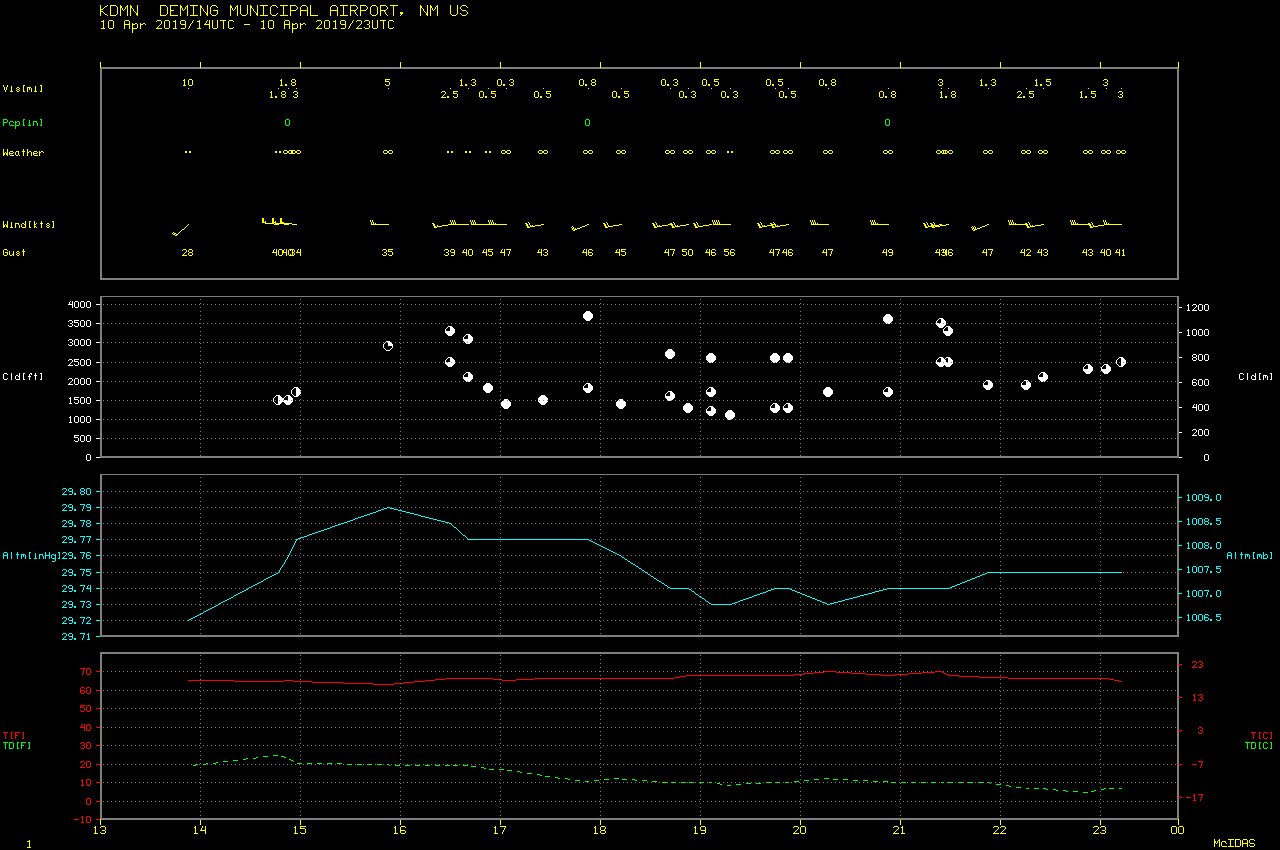
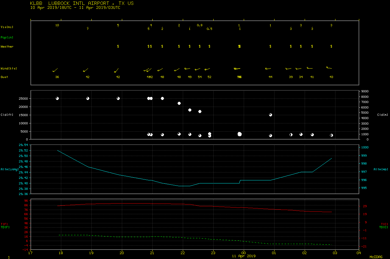
![GOES-16 Split Window (10.3-12.3 µm) images, with hourly plots of surface visibility [click to play animation | MP4]](https://cimss.ssec.wisc.edu/satellite-blog/wp-content/uploads/sites/5/2019/04/190410_goes16_splitWindow_visibility_AZ_NM_TX_blowing_dust_anim.gif)
GOES-16 Split Window (10.3-12.3 µm) images, with hourly plots of surface visibility [click to play animation | MP4]
![GOES-16 True Color RGB images [click to play animation | MP4]](https://cimss.ssec.wisc.edu/satellite-blog/wp-content/uploads/sites/5/2019/04/190410_goes16_truecolor_blowing_dust_anim.gif)
GOES-16 True Color RGB images [click to play animation | MP4]
![MODIS True Color RGB images from Terra and Aqua [click to enlarge]](https://cimss.ssec.wisc.edu/satellite-blog/wp-content/uploads/sites/5/2019/04/190410_terra_aqua_modis_truecolor_White_Sands_NM_anim.gif)
MODIS True Color RGB images from Terra and Aqua [click to enlarge]
![NOAA-20 True Color RGB image at 1928 UTC [click to enlarge]](https://cimss.ssec.wisc.edu/satellite-blog/wp-content/uploads/sites/5/2019/04/190410_1928utc_noaa20_viirs_truecolor_metars_anim.gif)
NOAA-20 True Color RGB image at 1928 UTC [click to enlarge]
Dust and sandstorms create conditions of reduced visibility near the surface and like volcanic ash can create a hazard when ingested into engine intakes. In this case, the dust storm was widespread so the @NWSAWC issued a SIGMET for IFR conditions as a warning to pilots. pic.twitter.com/QOpe1pIs9b
— Scott Dennstaedt (@AvWxWorkshops) April 11, 2019
===== 11 April Update =====
In a larger-scale view of GOES-16 Split Window images (below), the yellow dust signature could be followed during the subsequent overnight hours and into the following day on 11 April, as the aerosols were being transported northeastward across the Upper Midwest. There were widespread reports and photos of dust residue on vehicles and tan/brown-colored snow in parts of Nebraska, Iowa, Minnesota and Wisconsin.
![GOES-16 Split Window (10.3-12.3 µm) images [click to play animation | MP4]](https://cimss.ssec.wisc.edu/satellite-blog/wp-content/uploads/sites/5/2019/04/190410_190411_goes16_splitWindow_Central_US_blowing_dust_anim.gif)
GOES-16 Split Window (10.3-12.3 µm) images [click to play animation | MP4]
![IDEA forward trajectories initialized from a cluster of elevated Aqua MODIS Aerosol Optical Depth points over NM/TX [click to play animation]](https://cimss.ssec.wisc.edu/satellite-blog/wp-content/uploads/sites/5/2019/04/190410_aqua_modis_aod_trajectories_anim.gif)
IDEA forward trajectories initialized from a cluster of elevated Aqua MODIS Aerosol Optical Depth points over NM/TX [click to play animation]
![HYSPLIT model forward trajectories initialized at El Paso, Lubbock and Amarillo, Texas [click to enlarge]](https://cimss.ssec.wisc.edu/satellite-blog/wp-content/uploads/sites/5/2019/04/190411_00utc_dust_trajectories_2.png)
HYSPLIT model 24-hour forward trajectories initialized at El Paso, Lubbock and Amarillo, Texas [click to enlarge]
![GOES-16 True Color RGB images [click to play animation | MP4]](https://cimss.ssec.wisc.edu/satellite-blog/wp-content/uploads/sites/5/2019/04/190411_goes16_truecolor_Midwest_blowing_dust_anim.gif)
GOES-16 True Color RGB images [click to play animation | MP4]
===== 12 April Update =====
![GOES-16 Split Window (10.3-12.3 µm) images [click to play animation | MP4]](https://cimss.ssec.wisc.edu/satellite-blog/wp-content/uploads/sites/5/2019/04/190412_goes16_splitWindow_Central_US_blowing_dust_anim.gif)
GOES-16 Split Window (10.3-12.3 µm) images [click to play animation | MP4]
Ground-based lidar at the University of Wisconsin – Madison confirmed the presence of elevated levels of aerosol loading between the surface and 6 km.
![Lidar aerosol class [click to enlarge]](https://cimss.ssec.wisc.edu/satellite-blog/wp-content/uploads/sites/5/2019/04/category_20190412T0000_1200_15_am.jpg)
Lidar aerosol class [click to enlarge]