")
MODIS true color and false color RGB images (11 September)
")
MODIS true color and false color RGB images (12 September)
250-meter resolution MODIS true color and false color Red/Green/Blue (RGB) images from the SSEC MODIS Today site (above) showed the very large pyrocumulus and smoke plume from the Pagami Creek wildfire that was burning in the Boundary Waters Canoe Area Wilderness region of northeastern Minnesota on 11 September 2011 and 12 September 2011. The wildfire “hot spot” appears as the large red-colored feature on the false color images. Other options for viewing this MODIS imagery include the SSEC Web Mapping Service and WisconsinView sites: WMS MODIS image | WisconsinView: Terra and Aqua MODIS images.
A comparison of AWIPS images of 1-km resolution MODIS 0.65 µm visible channel, 3.7 µm shortwave IR channel, and 11.0 µm IR window channel data (below) revealed the very large fire “hot spot” on the shortwave IR image (red to yellow to black color enhancement) — and also note that the resulting pyrocumulus cloud just east of the fire hot spot exhibited a cloud top 11.0 µm IR window brightness temperature of -70º C (black color enhancement), which was just as cold as that associated with the thunderstorms farther to the north in Ontario, Canada!

MODIS 0.65 µm visible, 3.7 µm shortwave IR, and 11.0 µm IR images
AWIPS images of GOES-13 3.9 µm shortwave IR data (below) showed the diurnal changes to the size and intensity of the fire hot spot. Early in the animation during the overnight and morning hours, the hot spot was smaller and less intense as the wind speeds became very light– however, once strong southwesterly winds began to increase during the afternoon hours in advance of an approaching cold front, the hot spot was seen to dramatically increase in size as the fire quickly grew.
")
GOES-13 3.9 µm shortwave IR images (click image to play animation)
A comparison of the 4-km resolution GOES-13 3.9 µm and the 1-km resolution MODIS 3.7 µm shortwave IR images (below) demonstrated the advantage of better spatial resolution for more accurate location of the fire hot spot boundaries. In addition, the MODIS image revealed another small fire hot spot could be seen to the north, just across the Minnesota/Ontario border — this small fire was not seen on the GOES-13 image.

MODIS 3.7 µm and GOES-13 3.9 µm shortwave IR images
===== 13 September Update =====
A significant amount of smoke was transported southeastward across Wisconsin on 13 September 2011, as seen on GOES-13 0.63 µm visible channel images (below). The surface visibility was reduced to 2 miles at Milwaukee (station identifier KMKE), and 3 miles at Chicago O’Hare (station identifier KORD). Special Weather Statements were issued by the National Weather Service forecast offices at Milwaukee/Sullivan and Chicago/Romeoville to advise the public about the potential harmful effects of the smoke.
")
GOES-13 0.63 µm visible images (click image to play animation)
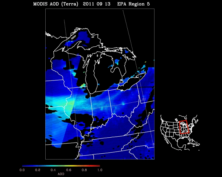
The smoke feature was even more apparent on the afternoon MODIS true color Red/Green/Blue (RGB) image (below), and this smoke produced an elevated signal on the MODIS Aerosol Optical Depth (AOD) product from the IDEA site.
 image")
MODIS true color Red/Green/Blue (RGB) image
CIMSS participation in GOES-R Proving Ground activities includes making a variety of MODIS images and products available for National Weather Service offices to add to their local AWIPS workstations. Currently there are 49 NWS offices receiving MODIS imagery and products from CIMSS.
View only this post Read Less


")
 and 07 September MODIS SST (right)")


")
")
