A comparison of AWIPS images of MODIS 0.65 µm visible channel data with the corresponding MODIS false-color Red/Green/Blue (RGB) image (above) showed a large swath of snow on the ground on 20 February 2012, in the wake of a winter storm that moved... Read More
 false color image")
MODIS 0.65 µm visible image + MODIS Red/Green/Blue (RGB) false color image
A comparison of AWIPS images of MODIS 0.65 µm visible channel data with the corresponding MODIS false-color Red/Green/Blue (RGB) image (above) showed a large swath of snow on the ground on 20 February 2012, in the wake of a winter storm that moved across the Mid-Atlantic region the previous day. The snow cover appears as shades of red on the false-color image, in contrast to the patches of supercooled water droplet clouds that persisted over the western half of the snow swath.
Farther to the west, strong winds (gusting to 60-70 mph) behind a cold front were causing an outbreak of blowing dust across parts of far eastern New Mexico and the Texas Panhandle. A comparison of a MODIS 0.65 µm visible channel image with the corresponding 1.3 µm “cirrus detection channel” image (below) demonstrated how the near-IR cirrus channel can be used to better identify the areal extent of the blowing dust (which might not be apparent on the visible channel imagery). The cirrus detection channel is sensitive to particles that are good scatterers of light, such as ice crystals, dust, volcanic ash, and smoke/haze.

MODIS 0.65 µm visible channel + MODIS 1.3 µm "cirrus detection channel" images
A comparison of the MODIS 0.65 µm visible channel image with the corresponding MODIS 11-12 µm IR difference product (below) demonstrates how 11-12 µm difference values of 1-2 degrees C (yellow color enhancement) highlighted areas where the dust concentration was highest. Airborne dust particles have different emissivities at the 11 µm and 12 µm wavelengths, which allows such an IR difference product to be used to locate and track blowing dust. Recall that the older series of GOES satellites (GOES-8 through GOES-11) had a 12.0 µm IR channel that allowed the creation of a similar IR difference product — but on the latest satellites (GOES-13 through GOES-15) the 12.0 µm IR channel was replaced with a 13.3 µm channel.

MODIS 0.65 µm visible channel image + MODIS 11-12 µm IR difference image
A closer view of the blowing dust cloud can be seen using 250-meter resolution MODIS true-color RGB images from the SSEC MODIS Today site (below). Some of the primary source regions of the blowing dust (located in New Mexico) can be seen on the earlier Terra image at 17:56 UTC.
 images")
Terra and Aqua MODIS true color Red/Green/Blue (RGB) images
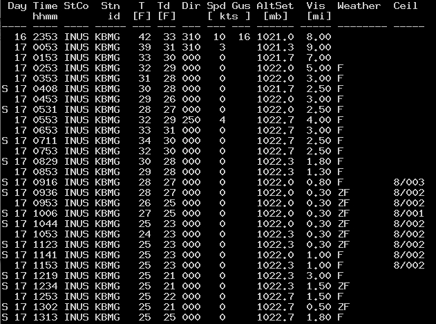
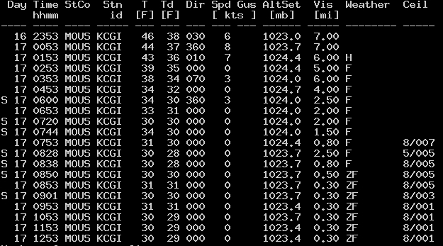
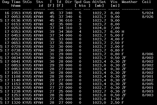
In the southeastern Texas Panhandle, a multiple-vehicle accident occurred along Highway 287 around 20:00 UTC (3:00 pm local time), causing a closure of that section of highway between Memphis and Childress (station identifier KCDS). McIDAS images of 1-km resolution GOES-13 0.63 µm visible channel data (below; click image to play animation) showed that an optically thick band of blowing dust was moving through the region between Memphis and Childress around the time of the accident.
")
GOES-13 0.63 µm visible channel images (click image to play animation)
View only this post
Read Less
")

")

 image (viewed using Google Earth)")
 images")
")


")
")
