
GOES-13 3.9 µm shortwave IR channel images
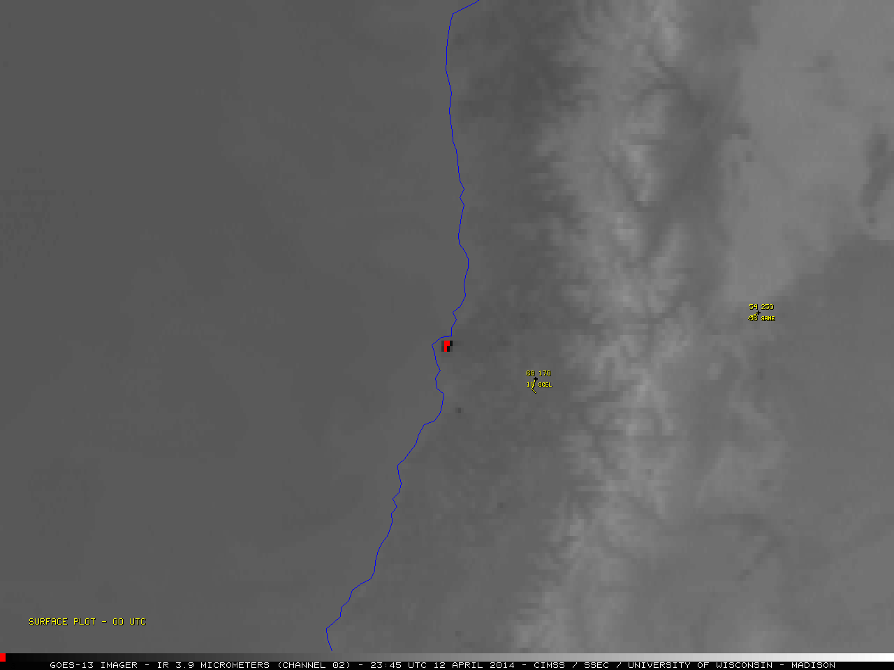
Strong winds helped a wildfire to spread very quickly through a portion of the city of ValparaÃso, Chile — this fire forced large-scale evacuations, destroyed around 2000 homes, and was responsible for 12 fatalities. McIDAS images of 4-km resolution GOES-13 3.9 µm shortwave IR channel data (above) showed the fire “hot spot” (black to red color enhancement), which began late in the day on 12 April 2014, and burned through the night and into the day on 13 April. The hottest 3.9 µm IR brightness temperatures were 339.6 K (66.45º C) at 20:45 UTC and 340.8 K (67.65º C) at 23:45 UTC on 12 April.
Since the GOES-13 satellite only performs one full-disk scan (hence imaging the Southern Hemisphere) every 3 hours, the temporal behavior of this fire cannot be well ascertained. The ABI instrument on the future GOES-R satellite will perform a full-disk scan every 5 minutes.
Comparisons of 1-km resolution GOES-13 visible channel images and 4-km resolution GOES-13 3.9 µm shortwave IR images (below) showed that the narrow fire smoke plume spread rapidly to the northwest.
 and 3.9 µm shortwave channel images (right)")
GOES-13 0.63 µm visible channel (left) and 3.9 µm shortwave channel images (right)
——————————————————————————————————–

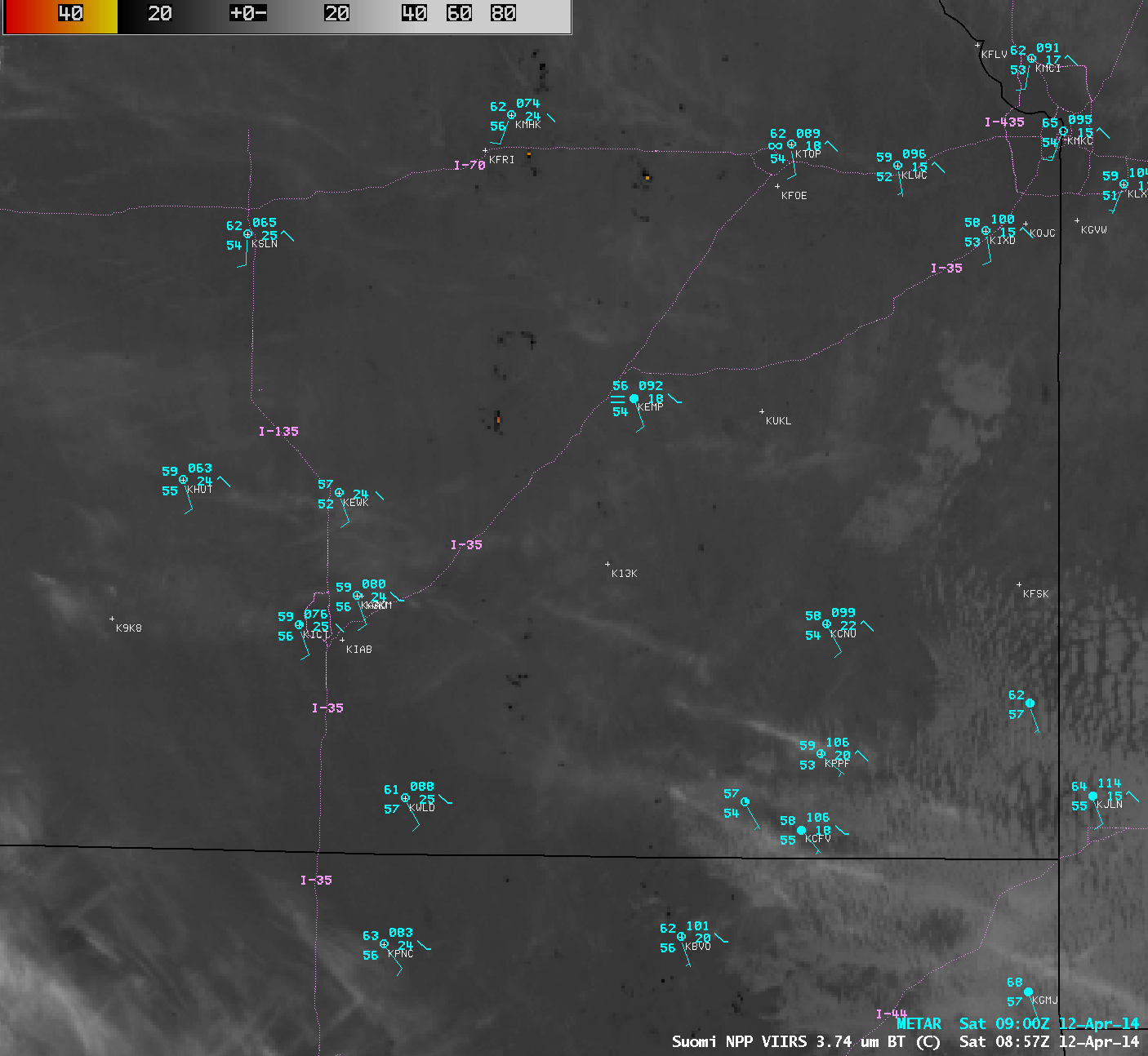
Suomi NPP VIIRS 3.74 µm shortwave IR image
A 375-meter resolution Suomi NPP VIIRS 3.74 µm (Band I4) shortwave IR image at 05:41 UTC (above) showed greater detail of the wildfire hot spot, which exhibited a maximum IR brightness temperature of 367.0 K (93.85º C). 367 K is actually the saturation temperature for the VIIRS Band I4 detectors, indicating that this was a very hot fire. Valparaiso is located about 112 km or 70 miles west-northwest of Santiago, Chile (station identifier SCEL).
By comparison, the 4-km resolution GOES-13 3.9 µm shortwave IR image close to that time (below) indicated that the maximum IR brightness temperature of the wildfire hot spot was only 316.5 K (43.35º C).
 and GOES-13 3.9 µm shortwave IR channel image (right)")
Suomi NPP VIIRS 3.74 µm shortwave IR channel image (left) and GOES-13 3.9 µm shortwave IR channel image (right)
McIDAS-V images of VIIRS 3.9 µm (Band M15) shortwave IR and 0.7 µm Day/Night Band (DNB) data (below; courtesy of William Straka, CIMSS/SSEC) revealed that the large fire hot spot (yellow to red color enhancement on the shortwave IR image) was adjacent to and encroaching upon the bright night-time city lights of the Valparaiso area (as seen on the Day/Night Band image). In addition, ample illumination from a nearly-full Moon allowed the smoke plume to be seen on the DNB image, as it drifted northwestward over the adjacent waters of the Pacific Ocean.

Suomi NPP VIIRS 3.9 µm shortwave IR and 0.7 µm Day/Night Band images
Fires had been burning in parts of Chile since January 2014. Additional information on this ValparaÃso fire can be found on the Wildfire Today site.
View only this post Read Less
")


")


")

")

")
