

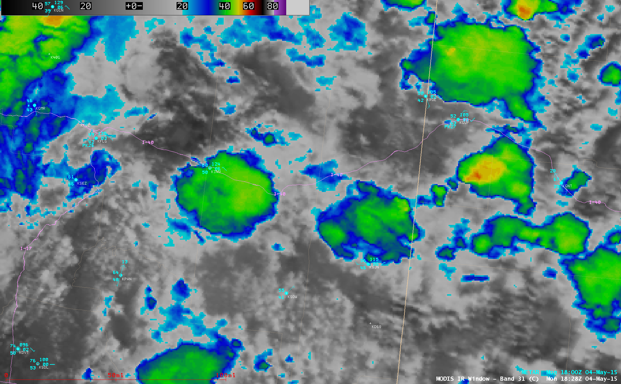
GOES-13 10.7 µm IR images (click to play animation)
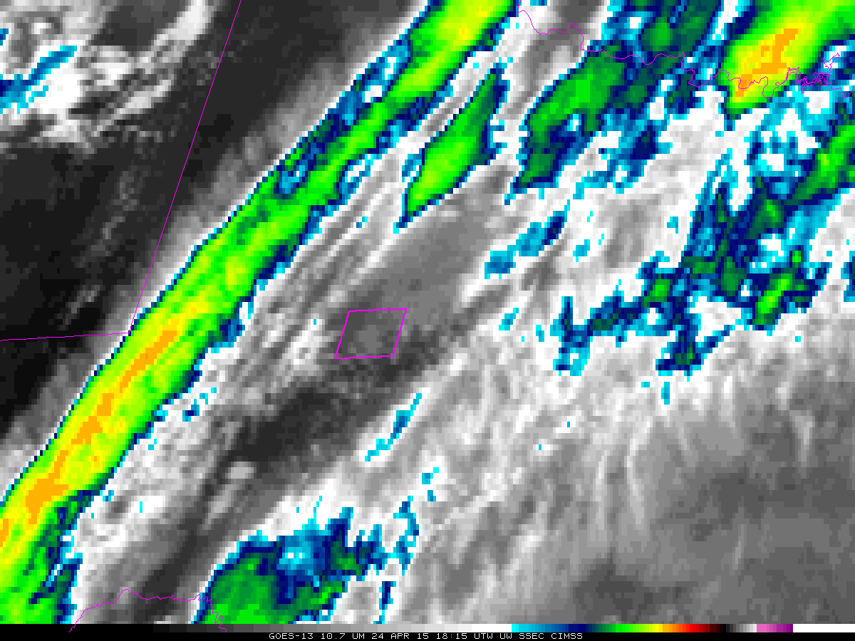
4-km resolution GOES-13 (GOES-East) 10.7 µm IR channel images (above; click image to play animation) showed the development and northward propagation of clusters of thunderstorms across Arizona on 04 May 2015. The coldest cloud-top IR brightness temperature was -49º C (darker red color enhancement). As the storms later organized into a mesoscale convective system, cloud-to-ground lightning strikes were seen to exceed 100 per 15-minute period.
A higher resolution view could be seen in a comparison of Suomi NPP VIIRS 0.7 µm Day/Night Band (DNB) and 11.45 µm IR channel images at 0940 UTC or 2:40 AM local time (below). Since the Moon was in the Waning Gibbous phase at 99% of full, this served as a good example of the “visible image at night” capability of the VIIRS Day/Night Band.
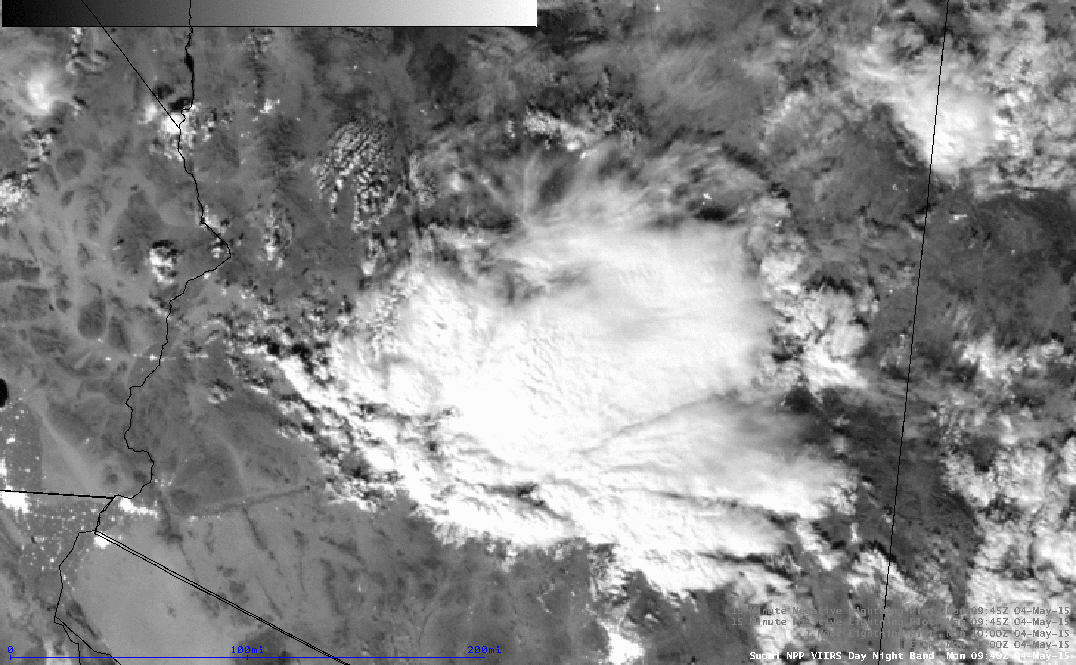
Suomi NPP VIIRS 0.7 µm Day/Night Band and 11.45 µm IR images, with METAR surface reports and 1-hour cloud-to-ground lightning strikes
One ingredient that aided in the thunderstorm development was rich moisture, as was noted in this excerpt from a NWS Phoenix forecast discussion:
AREA FORECAST DISCUSSION
NATIONAL WEATHER SERVICE PHOENIX AZ
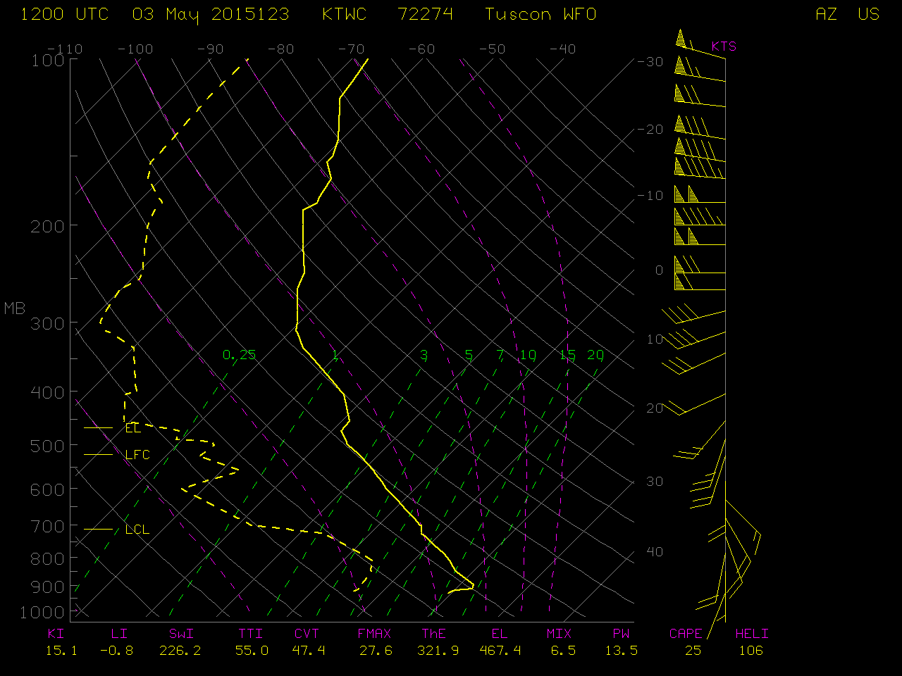
840 AM MST MON MAY 4 2015HOWEVER WHAT WAS NOT SO OBVIOUS…AND A MODEL FAILURE…WAS THE AMOUNT OF BOUNDARY LAYER MOISTURE ADVECTED INTO SOUTHERN AZ FROM MEXICO LATE YESTERDAY AFTERNOON AND NIGHT. JUST LOOK AT THIS MORNINGS TUCSON BALLOON SOUNDING. IT SHOWED AN 800 MB DEWPOINT OF 9 DEG C WHICH LOOKS MONSOONISH. IN OTHER WORDS THE BOUNDARY LAYER MOISTURE THROUGH 700 MB WAS IMPRESSIVE.
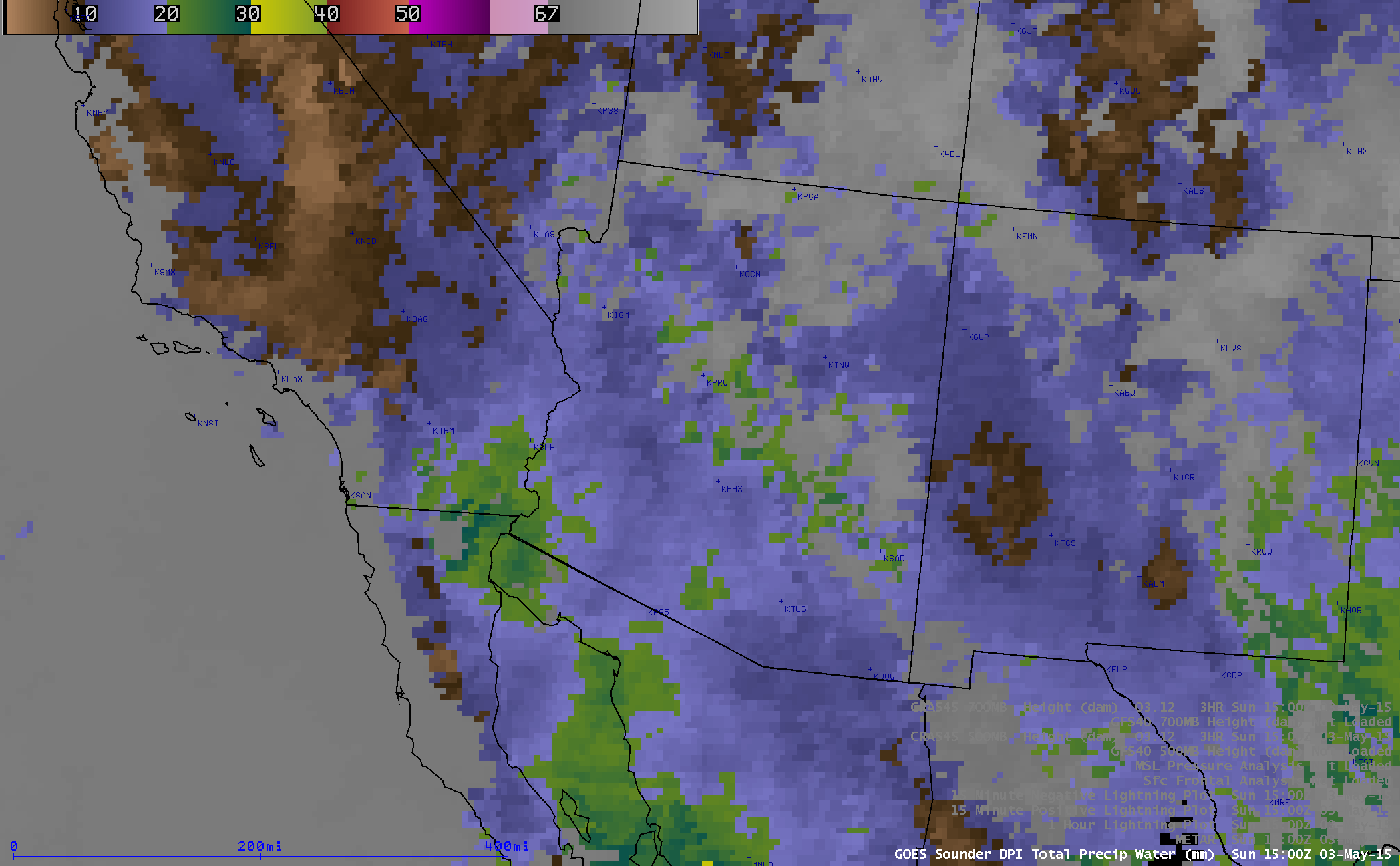
This northward transport of moisture could be seen on GOES-15 sounder Total Precipitatble Water (TPW) derived product images (below; click image to play animation); TPW values even exceeded 30 mm or 1.18 inches (yellow color enhancement) as early as 02 UTC on 04 May, reaching a peak of 33.4 mm or 1.3 inches at 04 UTC. A comparison of the Tucson rawinsonde data profiles from 12 UTC on 03 May and 00/12 UTC on 04 May can be seen here — TPW values at that location increased from 13.5 mm (0.53 inch) to 22.3 mm (0.88 inch) during that 24-hour period.
GOES-15 sounder Total Precipitable Water derived product images (click to play animation)
Later in the day on 04 May, as thunderstorms moved northward across the Interstate 40 corridor in northeastern Arizona, swaths of rain-cooled wet ground appeared as lighter-gray areas on the Aqua MODIS 11.0 µm IR image at 2008 UTC (below). These swaths of wet soil exhibited IR brightness temperatures that were as much as 10º C cooler than the adjacent dry soil surfaces which were heating up quickly during the early afternoon hours.
Terra (1828 UTC) and Aqua (2008 UTC) MODIS 11.0 µm IR images
The corresponding 2008 UTC Aqua MODIS Land Surface Temperature (LST) product (below) made it easier to discriminate between the cooler swaths of wet ground (LST values between 70 and 85º F, shades of green) and the adjacent areas of dry soil (LST values as warm as 100-116º F, darker shades of orange).

Aqua MODIS Land Surface Temperature product
View only this post Read Less

![MTSAT-2 10.8 µm (top) and Himawari-8 10.4 µm (bottom) IR images [click to play animation]](https://cimss.ssec.wisc.edu/satellite-blog/wp-content/uploads/sites/5/2015/04/150429_mtsat2_himawari8_ir_Cyclone_Quang_anim.gif)


