A storage facility in Tianjin, China exploded shortly after 1500 UTC on 12 August 2015 (media story). Himawari-8, MTSAT-2 and COMS-1 all viewed the explosion that generated a strong thermal signature in the shortwave infrared band (3.75 µm – 3.9 µm). The animation above shows the benefit of Himawari-8’s speedier scanning... Read More
![Himawari-8 (3.9 µm, top), MTSAT-2 (3.75 µm, middle) and COMS-1 (3.75 µm, bottom) shortwave infrared imagery, times as indicated [click to animate]](https://cimss.ssec.wisc.edu/satellite-blog/wp-content/uploads/sites/5/2015/08/HIMAWARI3PAN_NOMAP_12AUGUST2015_1630.GIF)
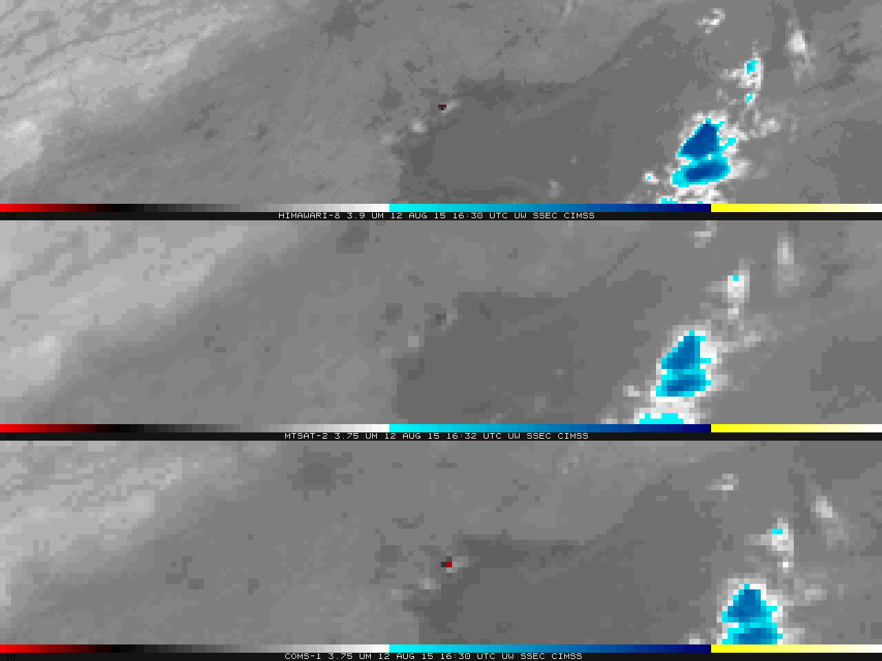
Himawari-8 (3.9 µm, top), MTSAT-2 (3.75 µm, middle) and COMS-1 (3.75 µm, bottom) shortwave infrared imagery, times as indicated [click to animate]
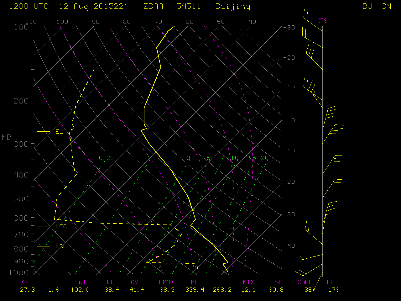
A storage facility in Tianjin, China exploded shortly after 1500 UTC on 12 August 2015 (
media story). Himawari-8, MTSAT-2 and COMS-1 all viewed the explosion that generated a strong thermal signature in the shortwave infrared band (3.75 µm – 3.9 µm). The animation above shows the benefit of Himawari-8’s speedier scanning mode: the smoke clouds that emanate from the explosion are easily traced, and data gaps when Full Disk images are being scanned (around 1800 UTC) are not present. Superior spatial resolution of Himawari-8 infrared channels (2-km, compared to 4-km for COMS-1 and MTSAT-2) means hotter brightness temperatures are sensed as well. The fact that smoke resulting from the explosion was seen spreading northeastward, southeastward, and southwestward was due to a marked shift in wind direction with height, as seen in the nearby
Beijing rawinsonde report.
The explosion exhibted a signal in other Himawari-8 AHI bands as well. Band 5, at 1.6 µm and Band 6, at 2.3 µm are shown below (animations courtesy of William Straka, CIMSS); Similar animations are available for 3.9 µm, 6.2 µm (very faintly visible in this upper tropospheric water vapor channel), 7.0 µm, 7.3 µm and 8.6 µm and 10.35 µm.
![Himawari-8 1.6 µm near-Infrared Imagery, times as indicated [click to enlarge]](https://cimss.ssec.wisc.edu/satellite-blog/wp-content/uploads/sites/5/2015/08/China_explosion_B05.gif)
Himawari-8 1.6 µm near-Infrared Imagery, times as indicated [click to animate]
![Himawari-8 1.6 µm near-Infrared Imagery, times as indicated [click to animate]](https://cimss.ssec.wisc.edu/satellite-blog/wp-content/uploads/sites/5/2015/08/China_explosion_B06.gif)
Himawari-8 1.6 µm near-Infrared Imagery, times as indicated [click to animate]
A view of Himawari-8 shortwave IR imagery using the
SSEC RealEarth web map server is shown below. In addition, an animation of Himawari-8 true-color images showing the dark smoke plume can be seen
here.
![Himawari-8 shortwave IR (3.9 um) images, displayed using RealEarth [click to enlarge]](https://cimss.ssec.wisc.edu/satellite-blog/wp-content/uploads/sites/5/2015/08/150812_himawari8_shortwaveIR_Tianjin_China_explosion_RealEarth_anim.gif)
Himawari-8 shortwave IR (3.9 um) images, displayed using RealEarth [click to enlarge]
========================== Added 14 August 2015 ===================
![Suomi NPP VIIRS Day/Night Band (0.70 um) visible images on 9 August (before explosion) and 13 August (after explosion) [click to enlarge]](https://cimss.ssec.wisc.edu/satellite-blog/wp-content/uploads/sites/5/2015/08/150809-150813_suomi_npp_viirs_dnb_Tianjin_explosion_power_outages_anim.gif)
Suomi NPP VIIRS Day/Night Band (0.70 um) visible images on 9 August (before explosion) and 13 August (after explosion) [click to enlarge]
The Suomi NPP satellite overflew Tianjin before and after the explosion; VIIRS Day/Night Band images afford views that suggest power outages around the explosion site.
View only this post
Read Less
![Himawari-8 10.35 µm IR images [click to play animated GIF]](https://cimss.ssec.wisc.edu/satellite-blog/wp-content/uploads/sites/5/2015/08/1200x1600_AHIM08_B13_TWINTYPHOON_animated_2015229_120000_86_2015229_235000_86_IR4AVHRR4.gif)
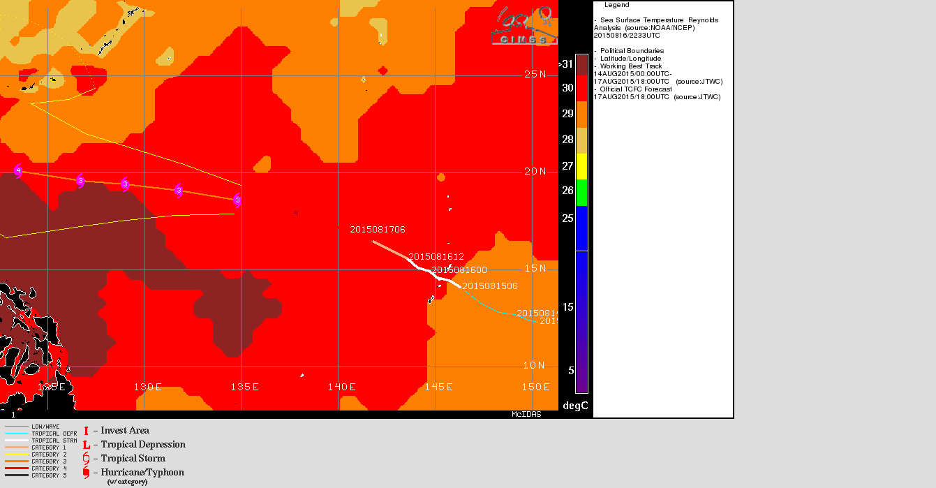
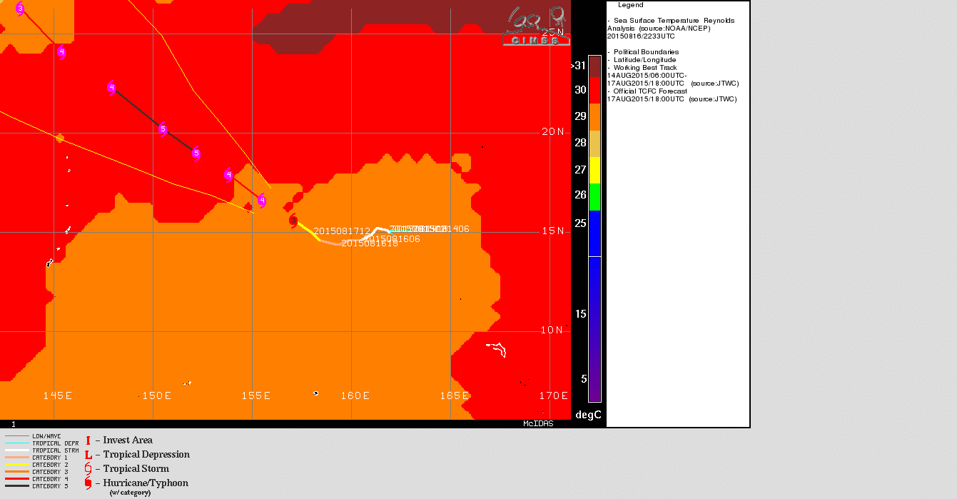
![Satellite-derived Wind Shear over the Pacific Ocean, 1800 UTC 17 August 2015 [click to enlarge]](https://cimss.ssec.wisc.edu/satellite-blog/wp-content/uploads/sites/5/2015/08/GONI_ATSANI_wgmsshr.GIF)
![MTSAT-2 infrared (10.8 µm) and DMSP SSMIS microwave (85 GHz) images of Typhoon Atsani [click to enlarge]](https://cimss.ssec.wisc.edu/satellite-blog/wp-content/uploads/sites/5/2015/08/150817_2032utc_mtsat_ir_ssmis_mw_Atsani_anim.gif)
![MIMIC-TC product for Typhoon Atsani [click to enlarge]](https://cimss.ssec.wisc.edu/satellite-blog/wp-content/uploads/sites/5/2015/08/150816-17_MIMIC_Atsani_erc_anim.gif)
![MIMIC-TC product for Typhoon Goni [click to enlarge]](https://cimss.ssec.wisc.edu/satellite-blog/wp-content/uploads/sites/5/2015/08/150816-17_MIMIC_Goni_erc_anim.gif)
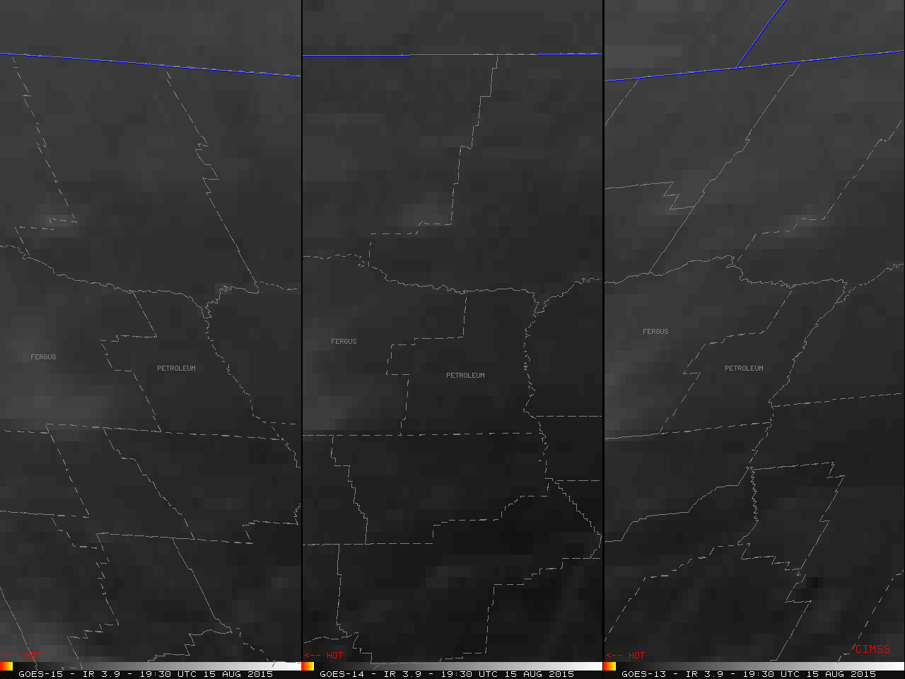
![GOES-15 (left), GOES-14 (center), and GOES-13 (right) 3.9 µm shortwave IR images [click to play MP4 animation]](https://cimss.ssec.wisc.edu/satellite-blog/wp-content/uploads/sites/5/2015/08/150815_G15_G14_G13_MT_FIRE_049.GIF)
![Terra/Aqua MODIS and Suomi NPP VIIRS 3.7 µm shortwave IR images [click to enlarge]](https://cimss.ssec.wisc.edu/satellite-blog/wp-content/uploads/sites/5/2015/08/150815_modis_viirs_shortwaveIR_MT_wildfire_anim.gif)
![GOES-13 visible (0.63 µm) images [click to play animation]](https://cimss.ssec.wisc.edu/satellite-blog/wp-content/uploads/sites/5/2015/08/150814_goes13_visible_Cotopaxi_volcano_anim.gif)
![GOES-13 infrared (10.7 µm) images [click to play animation]](https://cimss.ssec.wisc.edu/satellite-blog/wp-content/uploads/sites/5/2015/08/150814_goes13_ir_Cotopaxi_volcano_anim.gif)
![GOES-13 water vapor (6.5 µm) images [click to play animation]](https://cimss.ssec.wisc.edu/satellite-blog/wp-content/uploads/sites/5/2015/08/150814_goes13_water_vapor_Cotopaxi_volcano_anim.gif)
![Aqua MODIS true-color images [click to enlarge]](https://cimss.ssec.wisc.edu/satellite-blog/wp-content/uploads/sites/5/2015/08/150814_aqua_modis_truecolor_Cotopaxi_anim.gif)
![Suomi NPP VIIRS true-color image [click to enlarge]](https://cimss.ssec.wisc.edu/satellite-blog/wp-content/uploads/sites/5/2015/08/150814_1858utc_viirs_truecolor_Cotopaxi_google.png)
![Suomi NPP VIIRS visible (0.64 µm) and infrared (11.45 µm) images [click to enlarge]](https://cimss.ssec.wisc.edu/satellite-blog/wp-content/uploads/sites/5/2015/08/150814_1858utc_suomi_npp_viirs_visible_ir_Cotopaxi_anim.gif)
![Himawari-8 (3.9 µm, top), MTSAT-2 (3.75 µm, middle) and COMS-1 (3.75 µm, bottom) shortwave infrared imagery, times as indicated [click to animate]](https://cimss.ssec.wisc.edu/satellite-blog/wp-content/uploads/sites/5/2015/08/HIMAWARI3PAN_NOMAP_12AUGUST2015_1500_1900anim.gif)
