The first tropical storm of the season in the eastern Atlantic (Ana, Bill and Claudette all formed over the western Atlantic) has formed from a cluster of thunderstorms that emerged from Africa. The multi-day animation, above, from GOES-13, shows the steady progress of the disorganized system across the eastern Atlantic... Read More
![GOES-13 10.7 µm IR images [click to play animated GIF]](https://cimss.ssec.wisc.edu/satellite-blog/wp-content/uploads/sites/5/2015/08/800x1600_AGOES13_B4_DANNY_2015231_114500.GIF)
GOES-13 10.7 µm IR images [click to play animated GIF]
The first tropical storm of the season in the eastern Atlantic (Ana, Bill and Claudette all formed over the western Atlantic) has formed from a cluster of thunderstorms that emerged from Africa. The multi-day animation, above, from GOES-13, shows the steady progress of the disorganized system across the eastern Atlantic basin. Visible Imagery from GOES-13 and Meteosat-10, below, from the morning of 19 August, show the system near 40 W. The cyclonic curvature to the clouds is apparent; identification of the center in infrared imagery, below, is more difficult. Convection to the east of Danny has colder cloud top temperatures.
![Meteosat-10 0.6 µm Visible Image (Top, 1200 UTC) and GOES-13 0.63 µm Visible image (Bottom, 1145 UTC) on 19 August 2015 [click to enlarge]](https://cimss.ssec.wisc.edu/satellite-blog/wp-content/uploads/sites/5/2015/08/DANNY_VIS_1200_19AUG2015.GIF)
“Meteosat-10 0.6 µm Visible Image (Top, 1200 UTC) and GOES-13 0.63 µm Visible image (Bottom, 1145 UTC) on 19 August 2015 [click to enlarge]
![Meteosat-10 10.8 µm Infrared Image (Top, 1200 UTC) and GOES-13 10.7 µm Infrared image (Bottom, 1145 UTC) on 19 August 2015 [click to enlarge]](https://cimss.ssec.wisc.edu/satellite-blog/wp-content/uploads/sites/5/2015/08/DANNY_IR4_1200_19AUG2015.GIF)
“Meteosat-10 10.8 µm Infrared Image (Top, 1200 UTC) and GOES-13 10.7 µm Infrared image (Bottom, 1145 UTC) on 19 August 2015 [click to enlarge]
![ASCAT Winds with GOES-13 Water Vapor Imagery (6.5 µm), 0100 UTC 19 August 2015 [click to enlarge]](https://cimss.ssec.wisc.edu/satellite-blog/wp-content/uploads/sites/5/2015/08/ASCATWinds_0106_19Aug2015.png)
“ASCAT Winds with GOES-13 Water Vapor Imagery (6.5 µm), 0100 UTC 19 August 2015 [click to enlarge]
ASCAT winds from 0100 UTC on 19 August 2015 (above) show a compact circulation center with winds of 40 knots just north of 10 N and east of 40 W.
![Saharan Air Layer Tracking Product [click to play animated GIF]](https://cimss.ssec.wisc.edu/satellite-blog/wp-content/uploads/sites/5/2015/08/18August_1200.splitE.jpg)
Saharan Air Layer Tracking Product [click to play animated GIF]
A persistent impediment to Tropical Cyclone initiation in the eastern Atlantic this year has been widespread Saharan Air Layer dust. The one-day animation, above (taken from
this website), shows the SAL persists over the Atlantic; Danny has formed just to the south. Wind shear over Danny at present is weak (see below [
source]), and slow strenghtening is expected as Danny approaches the Caribbean.
![Mid-level Wind Shear [click to enlarge]](https://cimss.ssec.wisc.edu/satellite-blog/wp-content/uploads/sites/5/2015/08/1200UTC_19Aug_Danny_wg8midshr.GIF)
Mid-level Wind Shear [click to enlarge]
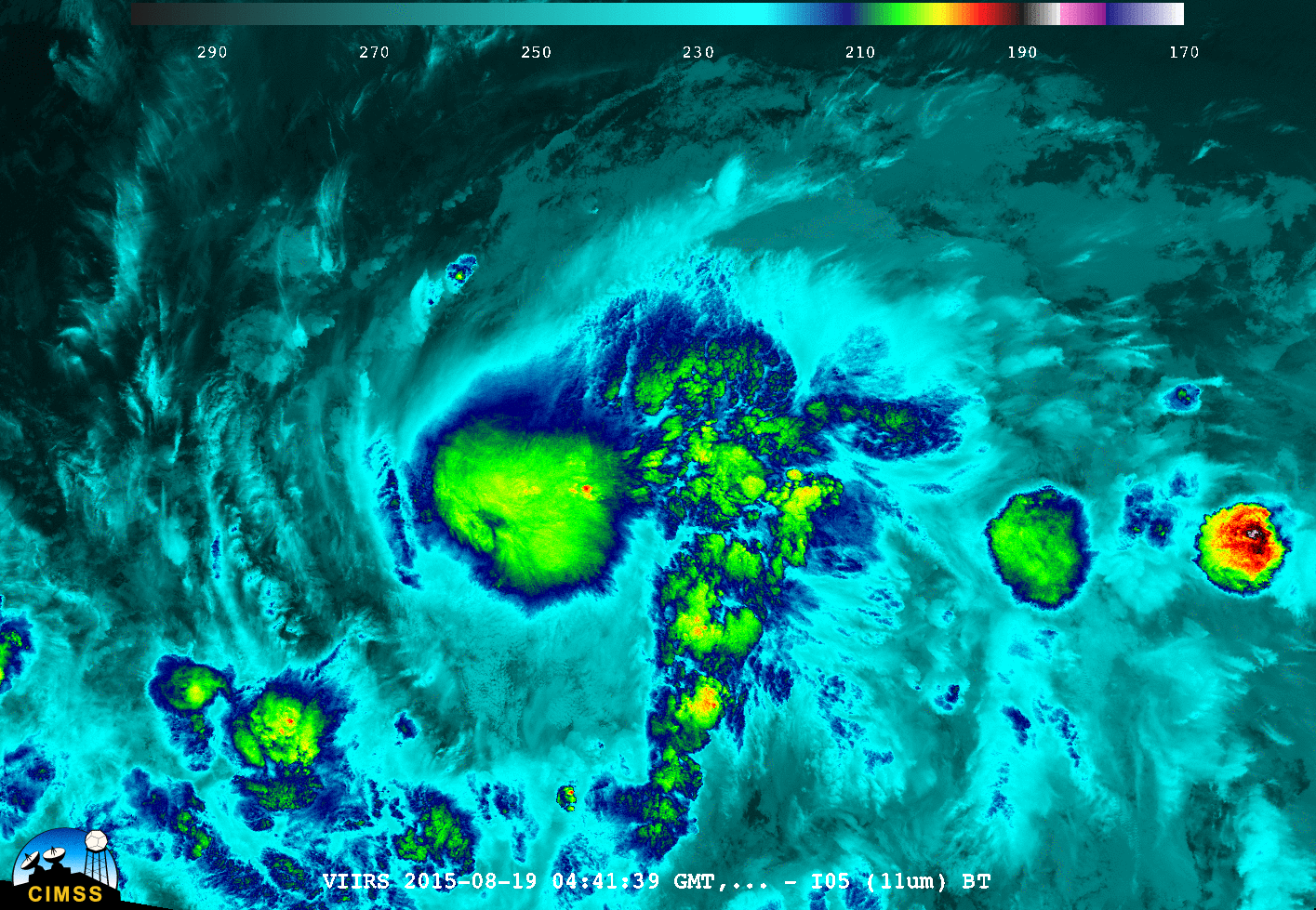
included this phrase: “The center is difficult to locate on infrared images,…” The Day Night Band from VIIRS on Suomi NPP can sometimes be used to locate low-level circulation centers of tropical systems. This relies on the presence of moonlight, however, and when Suomi NPP overflew Danny just before 0500 UTC on 19 August, the moon was below the horizon. Thus, the Day Night Band, below (Courtesy of William Straka) gave very little information.
![VIIRS 10.35 µm Infrared Imagery and 0.70 µm Visible Imagery, 0441 UTC 19 August 2015 [click to enlarge]](https://cimss.ssec.wisc.edu/satellite-blog/wp-content/uploads/sites/5/2015/08/I05_DNB_081915_0441_3E-10_TSDannytoggle.gif)
VIIRS 10.35 µm Infrared Imagery and 0.70 µm Visible Imagery, 0441 UTC 19 August 2015 [click to enlarge]
More information on Danny is available at the
CIMSS Tropical Weather Website. Consult the
National Hurricane Center for the latest updates and official forecasts.
View only this post
Read Less
![GOES-14 visible (0.63 um) images [click to play MP4 animation]](https://cimss.ssec.wisc.edu/satellite-blog/wp-content/uploads/sites/5/2015/08/960x1280_AGOES14_B1_DANNY_VIS_2015233_140000.GIF)
![Meteosat-10 Saharan Air Layer (SAL) product [click to play animation]](https://cimss.ssec.wisc.edu/satellite-blog/wp-content/uploads/sites/5/2015/08/150820-21_Danny_SAL_anim.gif)
![MIMIC Total Precipitable Water product [click to enlarge]](https://cimss.ssec.wisc.edu/satellite-blog/wp-content/uploads/sites/5/2015/08/150818-21_mimic_tpw_anim.gif)
![GOES-14 visible (0.63 µm) images [click to play MP4 animation]](https://cimss.ssec.wisc.edu/satellite-blog/wp-content/uploads/sites/5/2015/08/960x1280_AGOES14_B1_DANNY_VIS_zoom_2015233_200800.GIF)
![GOES-13 10.7 µm IR images [click to play animated GIF]](https://cimss.ssec.wisc.edu/satellite-blog/wp-content/uploads/sites/5/2015/08/800x1600_AGOES13_B4_DANNY_animated_2015227_114500_180_2015231_114500_180_IR4AVHRR4.gif)
![Meteosat-10 10.8 µm Infrared Image (Top, 1200 UTC) and GOES-13 10.7 µm Infrared image (Bottom, 1145 UTC) on 19 August 2015 [click to enlarge]](https://cimss.ssec.wisc.edu/satellite-blog/wp-content/uploads/sites/5/2015/08/DANNY_VIS_IR4_19AUG2015.GIF)
![Saharan Air Layer Tracking Product [click to play animated GIF]](https://cimss.ssec.wisc.edu/satellite-blog/wp-content/uploads/sites/5/2015/08/18-19August_1200.splitE.anim.gif)
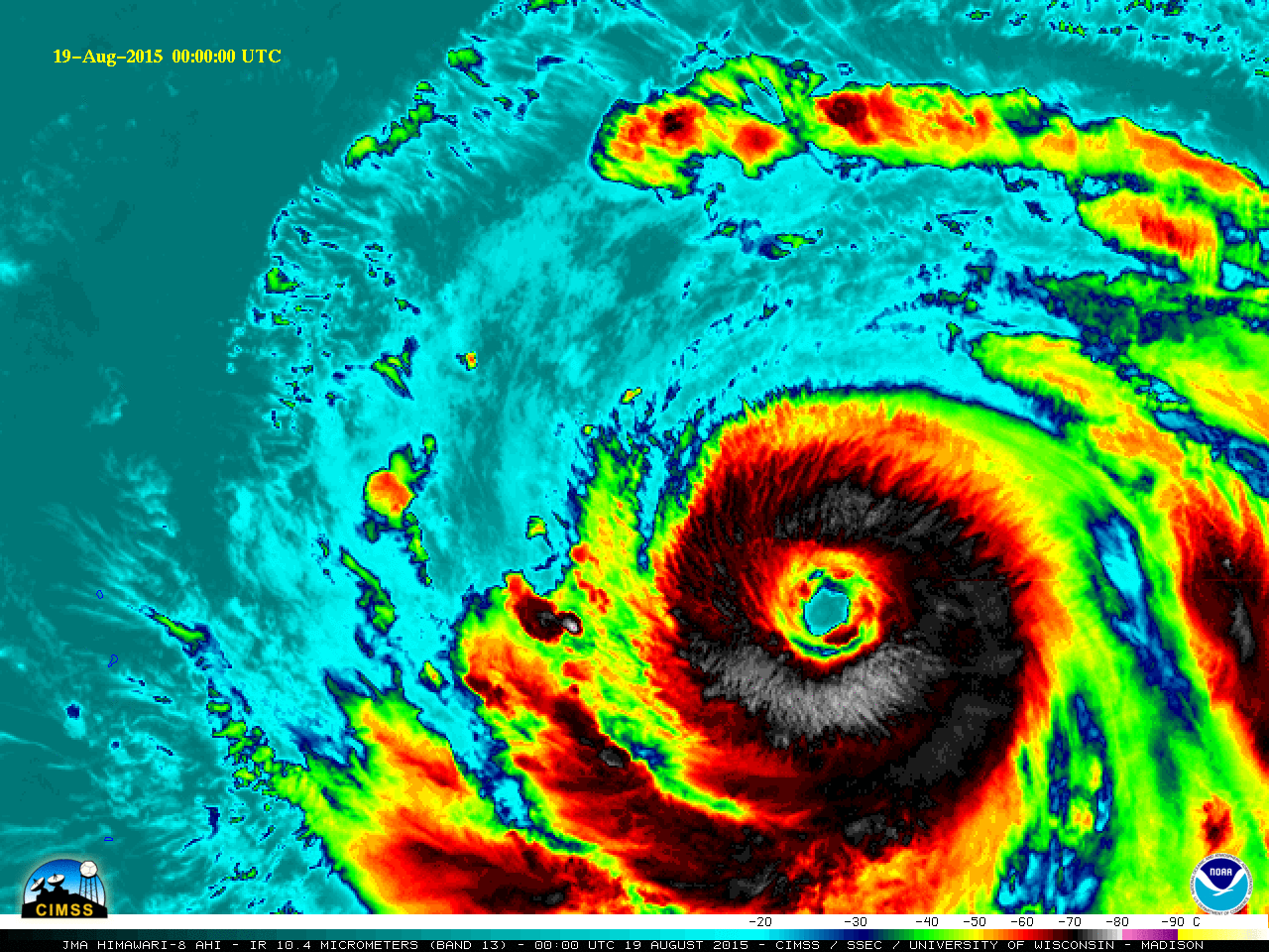
![Himawari-8 infrared (10.4 µm) imagery [click to play MP4 animation]](https://cimss.ssec.wisc.edu/satellite-blog/wp-content/uploads/sites/5/2015/08/960x1280_HIMAWARI_B13_ATSANI_IR_2015231_153000.GIF)
![DMSP SSMIS microwave (85 GHz) image and MTSAT-2 infrared (10.8 µm) image [click to enlarge]](https://cimss.ssec.wisc.edu/satellite-blog/wp-content/uploads/sites/5/2015/08/150819_20utc_ssmis_microwave_mtsat_ir_STY_Atsani_anim.gif)
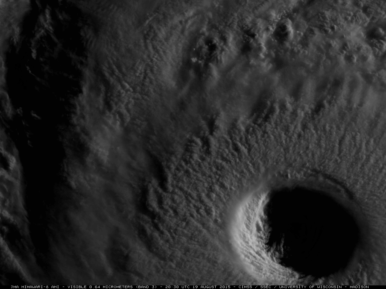
![Himawari-8 visible (0.64 um) images [click to play MP4 animation]](https://cimss.ssec.wisc.edu/satellite-blog/wp-content/uploads/sites/5/2015/08/150819_HIMAWARI8_VISIBLE_STY_ATSANI_017.GIF)
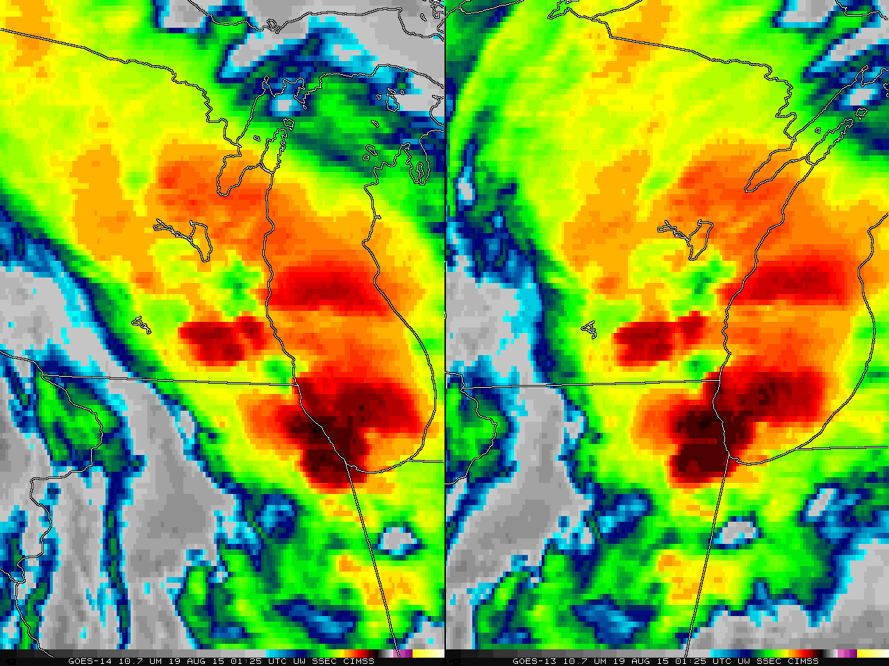
![GOES-14 (left) and GOES-13 (right) 10.7 µm IR images. Lake Geneva Wisconsin is indicated by the small white box [click to play animated GIF]](https://cimss.ssec.wisc.edu/satellite-blog/wp-content/uploads/sites/5/2015/08/GOES14GOES13_LAKEGENEVA_19AUGUST2015_0125-0230anim.gif)
![GOES-14 (left) and GOES-13 (right) 10.7 µm IR images, 0158 UTC 19 August 2015. Lake Geneva Wisconsin is indicated by the small white box [click to enlarge]](https://cimss.ssec.wisc.edu/satellite-blog/wp-content/uploads/sites/5/2015/08/GOES14GOES13_LAKEGENEVA_19AUGUST2015_0158.GIF)
![GOES-13 Automated Detection of Overshooting Tops (blue) and Thermal Couplets (Red) 2330 UTC 18 August 2015 - 0225 19 August 2015 [click to enlarge]](https://cimss.ssec.wisc.edu/satellite-blog/wp-content/uploads/sites/5/2015/08/overtop_east_20150818_2330_20150819_0215UTCanim.gif)
