This website works best with a newer web browser such as Chrome, Firefox, Safari or Microsoft Edge. Internet Explorer is not supported by this website.

GOES-16 water vapor imagery over far northern Canada

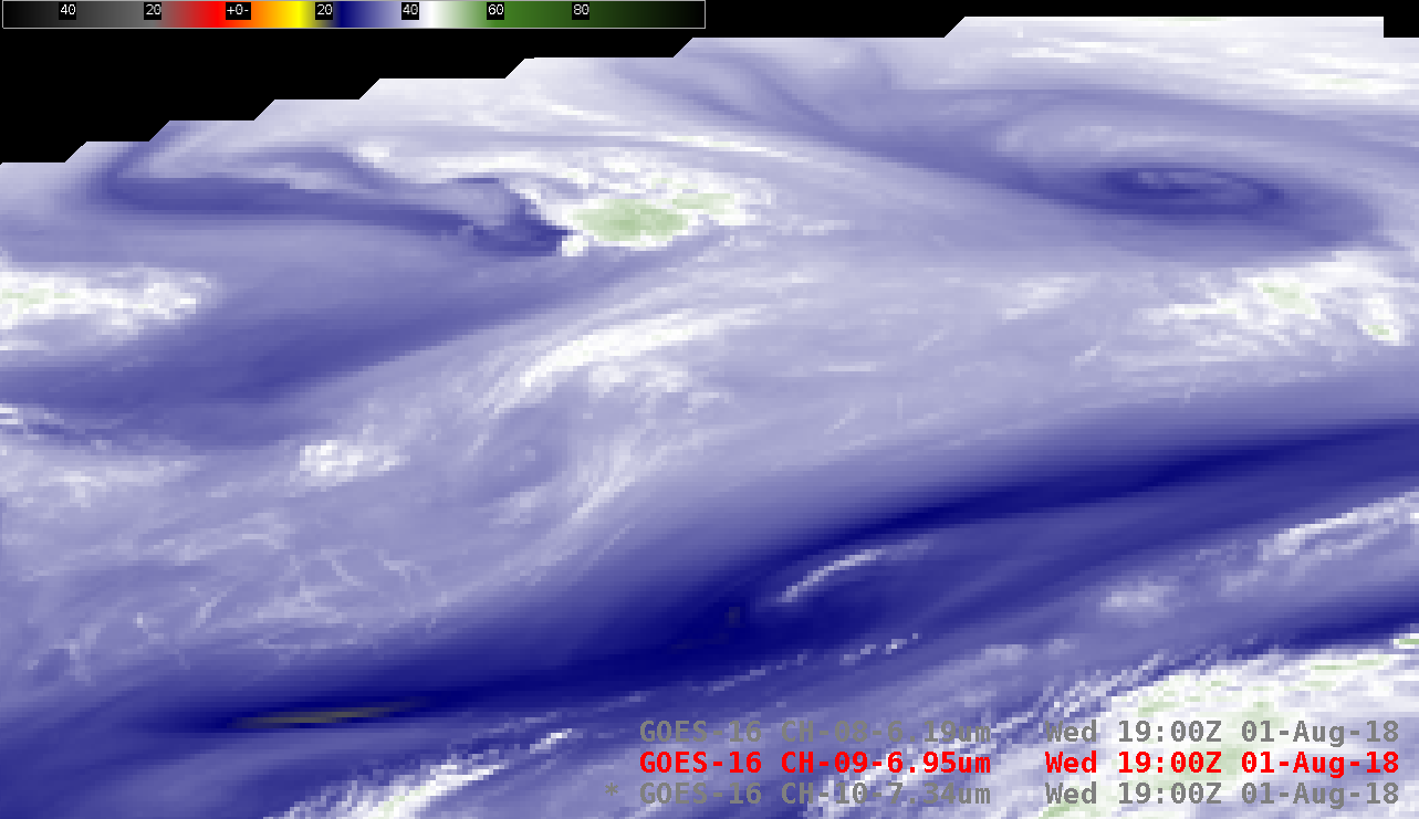
Animations of GOES-16 (GOES-East) Low-level (7.3 µm), Mid-level (6.9 µm) and Upper-level (6.2 µm) Water Vapor images (above) showed features moving eastward across Nunavut in northern Canada on 01 August 2018. These images covered the far northern portion of the GOES-16 Full Disk view in AWIPS, and depicted frontal wave disturbances within the polar jet stream... Read More

GOES-16 Low-level (7.3 µm), Mid-level (6.9 µm) and Upper-level (6.2 µm) Water Vapor images [click to play animation | MP4]

GOES-16 Low-level (7.3 µm), Mid-level (6.9 µm) and Upper-level (6.2 µm) Water Vapor images [click to play animation | MP4]

Animations of GOES-16 (GOES-East) Low-level (7.3 µm), Mid-level (6.9 µm) and Upper-level (6.2 µm) Water Vapor images (above) showed features moving eastward across Nunavut in northern Canada on 01 August 2018. These images covered the far northern portion of the GOES-16 Full Disk view in AWIPS, and depicted frontal wave disturbances within the polar jet stream over that region.

Due to the large satellite viewing angle or “zenith angle”, the 2 km water vapor image pixel dimension (at satellite sub-point) increased to around 6.4 km or 4 miles (below).

Magnified view of GOES-16 Mid-level (6.9 µm) Water Vapor image, showing the pixel dimension over Nunavut, Canada [click to enlarge]

Magnified view of a GOES-16 Mid-level (6.9 µm) Water Vapor image, showing the pixel dimension over Nunavut, Canada [click to enlarge]

Another effect of the large satellite view angle was a shift of the Water Vapor weighting functions to higher altitudes — plots of the 7.3 µm, 6.9 µm and 6.2 µm weighting functions calculated using 12 UTC rawinsonde data from Baker Lake, Nunavut are shown below. These plots depict the layers of the atmosphere from which emitted radiation was detected by each of the 3 Water Vapor spectral bands on the ABI instrument.

GOES-16 Water Vapor weighting function plots calculated using 12 UTC rawinsonde data from Baker Lake, Nunavut [click to enlarge]

GOES-16 Water Vapor weighting function plots calculated using 12 UTC rawinsonde data from Baker Lake, Nunavut [click to enlarge]

View only this post Read Less

Severe weather in southeastern Wyoming and eastern Colorado

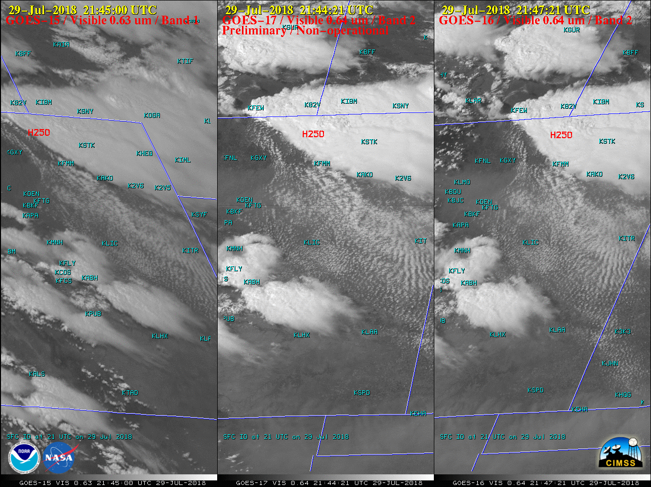
* GOES-17 images shown here are preliminary and non-operational *A comparison of GOES-15 (GOES-West), GOES-17 and GOES-16 (GOES-East) Visible images (above) showed thunderstorms which produced tornadoes, large hail and damaging winds (SPC storm reports) from southeastern Wyoming to eastern Colorado on 29 July 2018. The images are displayed in the native projections of each... Read More

Visible images from GOES-15 (0.63 µm, left), GOES-17 (0.64 µm, center) and GOES-16 (0.64 µm, right) [click to play MP4 animation]

Visible images from GOES-15 (0.63 µm, left), GOES-17 (0.64 µm, center) and GOES-16 (0.64 µm, right), with SPC storm reports plotted in red [click to play MP4 animation]

* GOES-17 images shown here are preliminary and non-operational *

A comparison of GOES-15 (GOES-West), GOES-17 and GOES-16 (GOES-East) Visible images (above) showed thunderstorms which produced tornadoes, large hail and damaging winds (SPC storm reports) from southeastern Wyoming to eastern Colorado on 29 July 2018. The images are displayed in the native projections of each satellite; images from GOES 16/17 are at 5-minute intervals, while those from GOES-15 are at intervals ranging from 4 to 30 minutes (depending on the operational scan schedule for that GOES-West satellite).

The first infrared images (NOAA/NESDIS News) from GOES-17 (below) also showed the development of these severe thunderstorms. The coldest cloud-top Infrared Window (11.2 µm) brightness temperatures over eastern Colorado were around -70ºC (dark black enhancement) after about 2200 UTC.

GOES-17 Infrared (11.2 µm) images [click to play animation | MP4]

GOES-17 Infrared (11.2 µm) images [click to play animation | MP4]

Images from all 16 spectral bands of the GOES-17 ABI are shown below. Prior to the development of convective storms, mountain waves could be seen over Wyoming and Colorado on Water Vapor bands 8 (6.17 µm), 9 (6.93 µm) and 10 (7.34 µm).

All 16 bands of the GOES-17 ABI [click to play animation | MP4]

Images from all 16 bands of the GOES-17 ABI [click to play animation | MP4]

View only this post Read Less

Tornadoes in Wyoming

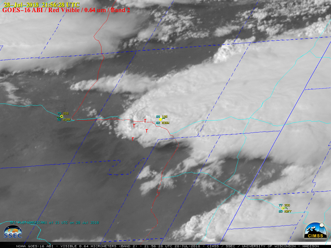
1-minute Mesoscale Domain Sector GOES-16 (GOES-East) “Red” Visible (0.64 µm) images (above) showed the development of a supercell thunderstorm that produced tornadoes, large hail and damaging winds (SPC storm reports) across parts of eastern Wyoming on 28 July 2018. A distinct above-anvil cirrus plume could be seen with this storm.The corresponding GOES-16 “Clean” Infrared Window (10.3 µm) images (below) revealed... Read More

GOES-16

GOES-16 “Red” Visible (0.64 µm) images, with hourly plots of surface observations (cyan/yellow) along with SPC storm reports and Interstate Highways (red) and State Highways (cyan) [click to play MP4 animation]

1-minute Mesoscale Domain Sector GOES-16 (GOES-East) “Red” Visible (0.64 µm) images (above) showed the development of a supercell thunderstorm that produced tornadoes, large hail and damaging winds (SPC storm reports) across parts of eastern Wyoming on 28 July 2018. A distinct above-anvil cirrus plume could be seen with this storm.

The corresponding GOES-16 “Clean” Infrared Window (10.3 µm) images (below) revealed that the dominant northern storm began to exhibit a well-defined enhanced-V signature (2051 UTC image) about an hour before it began to produce tornadoes. Minimum cloud-top infrared brightness temperatures were in the -60 to -65ºC range (darker shades of red) with the stronger pulses of overshooting tops.

GOES-16 "Clean" Infrared Window (10.3 µm) images, with hourly plots of surface observations (yellow) along with SPC storm reports (cyan) Interstate Highways (violet) and State Highways (cyan) [click to play MP4 animation]

GOES-16 “Clean” Infrared Window (10.3 µm) images, with hourly plots of surface observations (yellow) along with SPC storm reports (cyan) Interstate Highways (violet) and State Highways (cyan) [click to play MP4 animation]

A sequence of Infrared Window images from Suomi VIIRS (11.45 µm) and Aqua MODIS (11.0 µm) (below) showed minimum cloud-top infrared brightness temperatures rapidly cooling from the -40s to -72ºC as the dominant storm crossed Interstate 25.

Suomi NPP VIIRS and Aqua MODIS Infrared Window images [click to enlarge]

Infrared Window images from Suomi NPP VIIRS (11.45 µm) and Aqua MODIS (11.0 µm) [click to enlarge]

A comparison of the Terra and Aqua MODIS Total Precipitable Water product (below) indicated that TPW values increased from the 10-20 mm range to the 20-30 mm range in less than 2 hours.

Terra and Aqua MODIS Total Precipitable Water product [click to enlarge]

Terra and Aqua MODIS Total Precipitable Water product [click to enlarge]

View only this post Read Less

Carr Fire pyrocumulonimbus in California

1-minute Mesoscale Domain Sector GOES-16 (GOES-East) “Red” Visible (0.64 µm) and Shortwave Infrared (3.9 µm) images (above) showed the large thermal anomaly or “hot spot” (cluster of red pixels) associated with the Carr Fire in northern California as it produced a pyrocumulonimbus (pyroCb) cloud during the afternoon hours on 27 July 2018. A 30-meter resolution Landsat-8 False Color image from... Read More
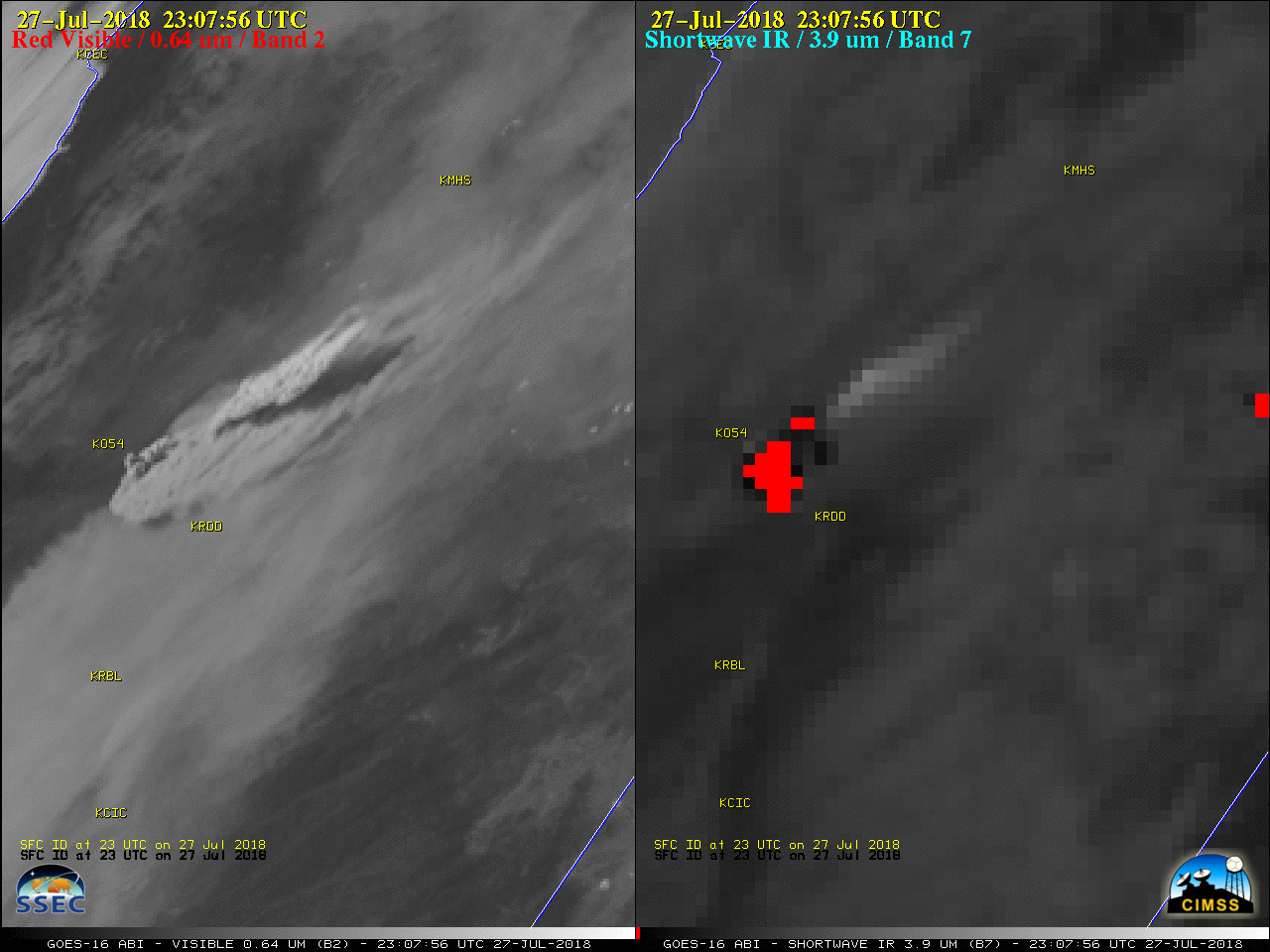
GOES-16

GOES-16 “Red” Visible (0.64 µm, left) and Shortwave Infrared (3.9 µm, right) images [click to play MP4 animation]

1-minute Mesoscale Domain Sector GOES-16 (GOES-East) “Red” Visible (0.64 µm) and Shortwave Infrared (3.9 µm) images (above) showed the large thermal anomaly or “hot spot” (cluster of red pixels) associated with the Carr Fire in northern California as it produced a pyrocumulonimbus (pyroCb) cloud during the afternoon hours on 27 July 2018. A 30-meter resolution Landsat-8 False Color image from the previous day showed the large size of the burn scar; extreme fire behavior on 27 July caused the Carr Fire to quickly increase in size and move closer to Redding CA, and also produce the pyroCb.

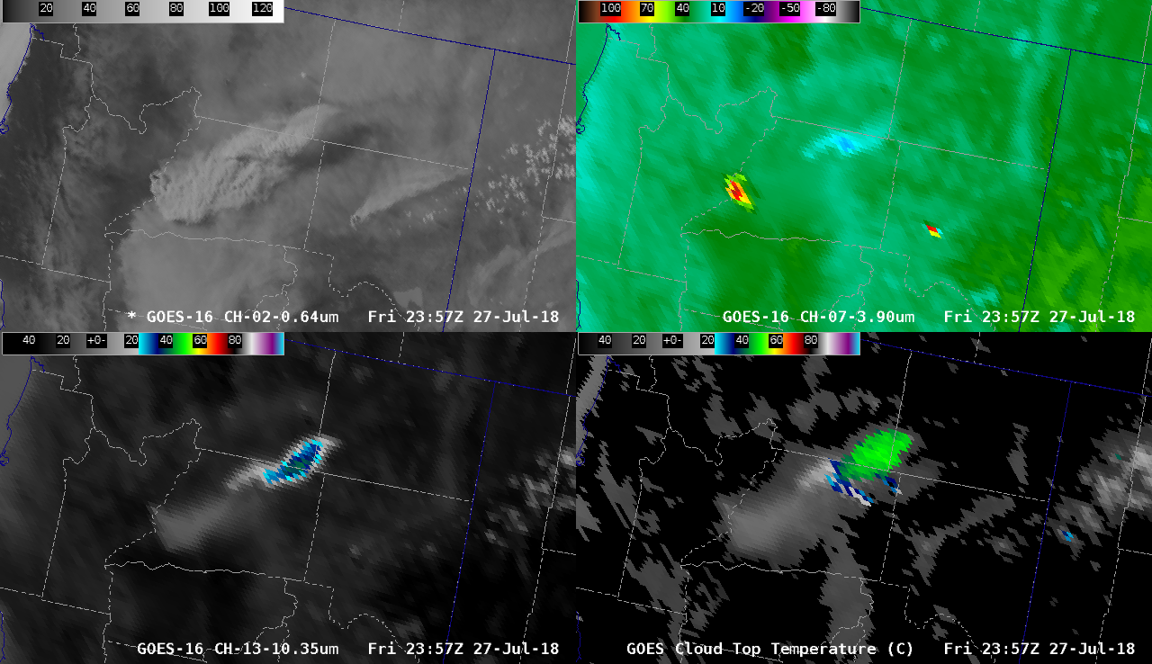
Another view using GOES-16 “Red” Visible, Shortwave Infrared, “Clean” Infrared Window (10.3 µm) and the Cloud Top Temperature product (below) showed the pyroCb cloud as it drifted rapidly northeast over Nevada and Oregon, along with a second (albeit smaller) pyroCb cloud which developed around 0130 UTC. One standard parameter used for defining a pyroCb cloud is a minimum cloud-top longwave infrared brightness temperature of -40ºC (ensuring complete glaciation) — and in this case with 1-minute imagery, the multi-spectral Cloud Top Temperature (CTT) product (FAQ) indicated that the pyroCb cloud reached the -40ºC threshold 19 minutes earlier than the 10.3 µm infrared imagery. From that point forward, the CTT product was consistently at least 5-10ºC colder than the 10.3 µm brightness temperature; the CTT product eventually displayed a minimum value of -53.9ºC over northeastern California. Even as the 10.3 µm brightness temperature began to rapidly warm after about 0100 UTC, the CTT product continued to display values in the -45 to -50ºC range (shades of green) which allowed for unambiguous tracking of the pyroCb.

GOES-16 "Red" Visible (0.64 µm, top left), Shortwave Infrared (3.9 µm, top right), "Clean" Infrared Window (10.3 µm, bottom left) and Cloud Top Temperature product (bottom right) [click to play MP4 animation]

GOES-16 “Red” Visible (0.64 µm, top left), Shortwave Infrared (3.9 µm, top right), “Clean” Infrared Window (10.3 µm, bottom left) and Cloud Top Temperature product (bottom right) [click to play MP4 animation]

In the case of the second (smaller) pyroCb cloud that formed from the Carr Fire after 0130 UTC, the 10.3 µm brightness temperature failed to reach the -40ºC threshold, while the CTT product again displayed values in the -45 to -50ºC range. The coldest CTT value of -53.9ºC (seen with the initial pyroCb) roughly corresponded to an altitude of 12.5 km or 41,000 feet according to 00 UTC rawinsonde data from Reno, Nevada (below). Strong upper-tropospheric winds of 80-90 knots rapidly transported the pyroCb anvil northeastward.

Plot of 00 UTC rawinsonde data from Reno, Nevada [click to enlarge]

Plot of 00 UTC rawinsonde data from Reno, Nevada [click to enlarge]

View only this post Read Less