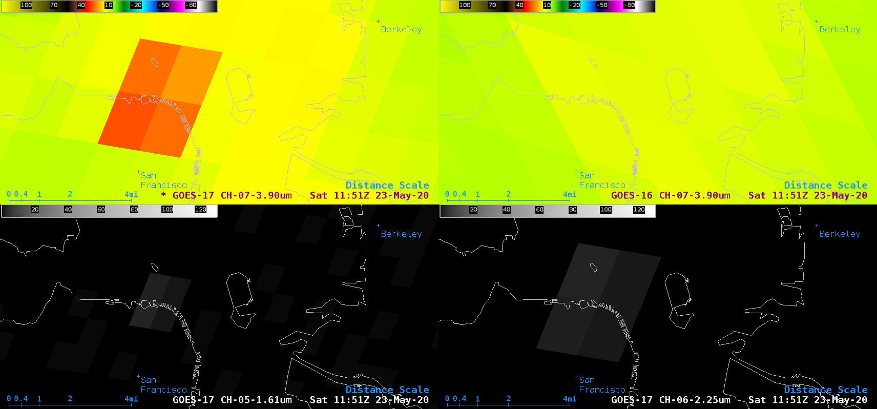
The thermal signature of a large nighttime fire at Pier 45 in San Francisco (media report) was evident in Shortwave Infrared (3.9 µm) images from GOES-17 (GOES-West) and GOES-16 (GOES-East) — the warmest 3.9 µm brightness temperature sensed by GOES-17 was 27.8ºC (at 1151 UTC), while the warmest temperature sensed by GOES-16 was... Read More
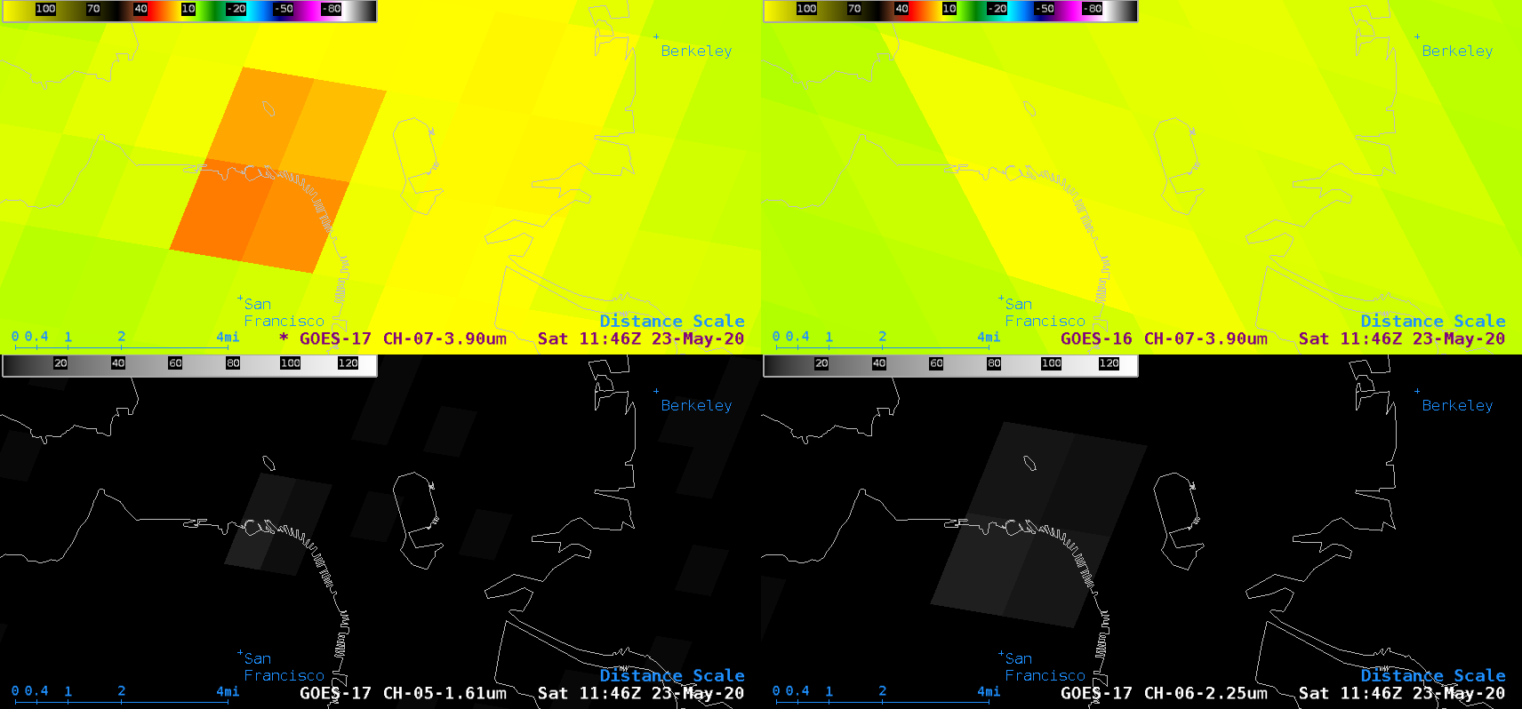
![GOES-17 Shortwave Infrared (3.9 µm, top left), GOES-16 Shortwave Infrared (3.9 µm, top right), GOES-17 Near-Infrared "Snow/Ice" (1.61 µm, bottom left) and GOES-17 Near-Infrared "Cloud Particle Size" (2.24 µm, bottom right) [click to enlarge]](https://cimss.ssec.wisc.edu/satellite-blog/images/2020/05/200523_goes17_goes16_shortwaveInfrared_nearInfrared_SFO_fire_anim.gif)
GOES-17 Shortwave Infrared (3.9 µm, top left), GOES-16 Shortwave Infrared (3.9 µm, top right), GOES-17 Near-Infrared “Snow/Ice” (1.61 µm, bottom left) and GOES-17 Near-Infrared “Cloud Particle Size” (2.24 µm, bottom right) [click to enlarge]
The thermal signature of a large nighttime fire at Pier 45 in San Francisco (
media report) was evident in Shortwave Infrared (
3.9 µm) images from GOES-17
(GOES-West) and GOES-16
(GOES-East) — the warmest 3.9 µm brightness temperature sensed by GOES-17 was 27.8ºC (at
1151 UTC), while the warmest temperature sensed by GOES-16 was only 14.2ºC (at
1146 UTC).
Note that a faint thermal signature of the fire (pixels exhibiting dim shades of white) was also apparent in GOES-17 Near-Infrared “Snow/Ice” (1.61 µm) and GOES-17 Near-Infrared “Cloud Particle Size” (2.24 µm) images. This is because those two ABI spectral bands are located close to the peak emitted radiance of very hot features such as volcanic eruptions or large fires (below).
![Plots of Spectral Response Functions for ABI Bands 5, 6 and 7 [click to enlarge]](https://cimss.ssec.wisc.edu/satellite-blog/wp-content/uploads/sites/5/2018/08/ABI_Band_5_6_7_Spectral_Response_Functions_Fires.png)
Plots of Spectral Response Functions for ABI Bands 5, 6 and 7 [click to enlarge]
Just after sunrise, the northward meandering of smoke could be seen in GOES-17 “Red” Visible (0.64 µm) images (below).
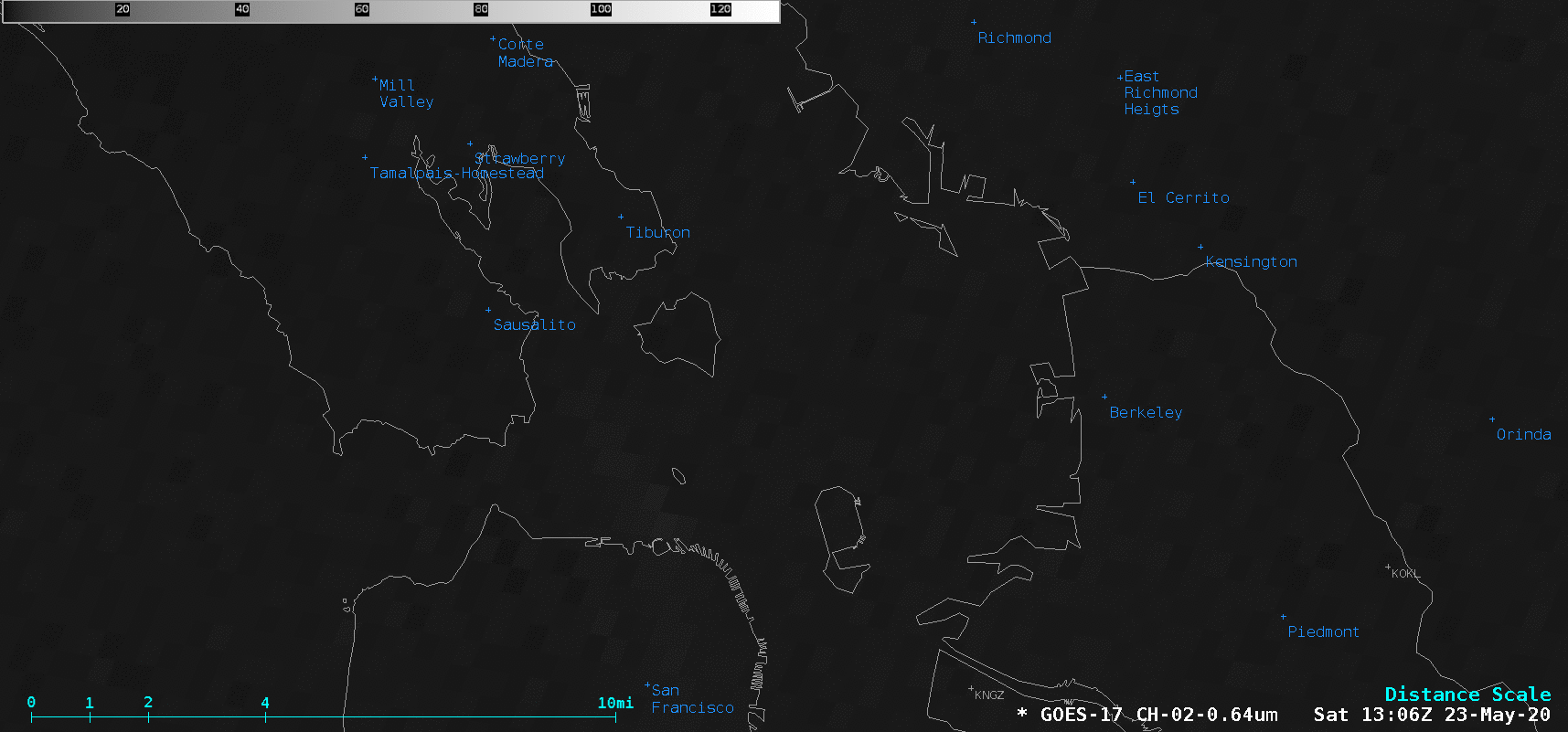
GOES-17 “Red” Visible (0.64 µm) images [click to enlarge]
However, a larger-scale view of GOES-17 True Color Red-Green-Blue (RGB) images created using
Geo2Grid (below) revealed that filaments of higher-altitude smoke were drifting southward, while the aforementioned low-latitude smoke was drifting more slowly northward.
![GOES-17 True Color RGB images [click to play animation | MP4]](https://cimss.ssec.wisc.edu/satellite-blog/images/2020/05/GOES-17_ABI_RadC_true_color_2020144_133117Z.png)
GOES-17 True Color RGB images [click to play animation | MP4]
A profile of 12 UTC rawinsonde data from Oakland
(below) explained these differences in smoke transport — winds at higher altitudes were stronger, and had a northerly component.
![Plot of 12 UTC rawinsonde data from Oakland, California [click to enlarge]](https://cimss.ssec.wisc.edu/satellite-blog/images/2020/05/200523_12UTC_KOAK_RAOB.GIF)
Plot of 12 UTC rawinsonde data from Oakland, California [click to enlarge]
View only this post
Read Less

![GOES-16 Total Precipitable Water product [click to play animation | MP4]](https://cimss.ssec.wisc.edu/satellite-blog/images/2020/05/200526_goes16_totalPrecipitableWater_South_Florida_anim.gif)
![MIMIC Total Precipitable Water product [click to enlarge]](https://cimss.ssec.wisc.edu/satellite-blog/images/2020/05/200526_mimicTPW_anim.gif)


![GOES-17 True Color RGB images [click to play animation | MP4]](https://cimss.ssec.wisc.edu/satellite-blog/images/2020/05/200523_goes17_trueColorRGB_SFO_fire_smoke_anim.gif)
